Browse Listings
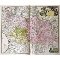
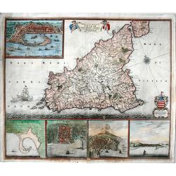
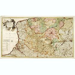
Tabula comitatus Artesiae emendata...
A large-scale map of Nord-Pas-de-Calais, packed with incredible detail. Even the smallest villages are shown, including a network of roads, rivers, forests, etc. With Cal...
Date: Amsterdam, ca 1680
Selling price: ????
Please login to see price!
Sold in 2016
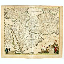
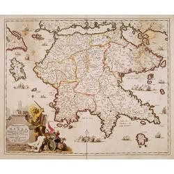
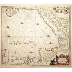
Nova Persiae Armeniae Natoliae et Arabiae.
East from Cyprus to Iran with numerous place names and ornamental cartouches below. There are vignettes of sailing ships in sea areas and the land divisions of the time a...
Date: Amsterdam, 1680
Selling price: ????
Please login to see price!
Sold in 2016
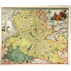
Comitatus Hannonia et Episcopatus Cambresis Descriptio Auctore
A pleasing map of the Belgian region of Hannonia. Adorned with a cartouche including a coat of arms with soldiers on horses surrounding. Also has an interesting vertical ...
Date: Amsterdam, 1680
Selling price: ????
Please login to see price!
Sold in 2016
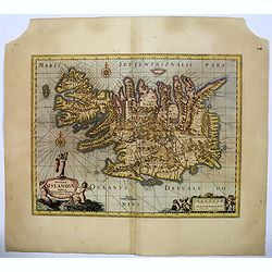
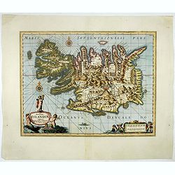
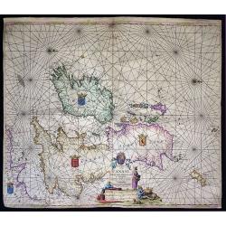
Novissima Islandiae Tabula.
A beautiful map of Iceland, embellished with cartouches, compass roses, rhumb lines, and many other decorative features - all done in the style of Blaeu and Jansson by Mo...
Date: Oxford, 1680
Selling price: ????
Please login to see price!
Sold in 2016
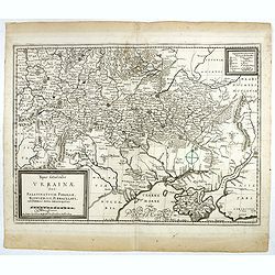
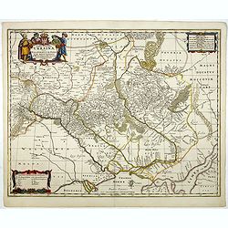
Typus Generalis Ukrainae sive Palatinatuum Podoliae, Kioviensis et Braczlaviensis terras nova delineatione exhibens. . .
Key map based on Guillaume La Vasseur de Beauplan's map of the region published in "Description d'Ukraine". The work described Ukraine as several provinces of t...
Date: Nuremberg, ca. 1680
Selling price: ????
Please login to see price!
Sold in 2016
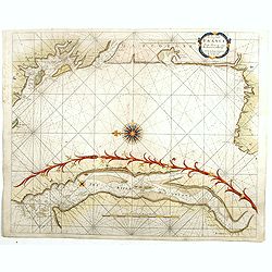
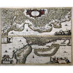
The Sea Coasts of France from Olone to Cape Machiacaca in Biscay.
Detailed chart of Biscay Bay, showing the Coast of Southwestern France and Northwestern Spain, originally engraved by John Seller, here with the address "Sold by Ri....
Date: London, ca. 1680
Selling price: ????
Please login to see price!
Sold
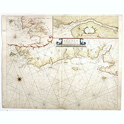
The Sea Coasts of France from Ufhent to Olone . . .
Detailed chart of Biscay Bay, showing the Coast of Brittany. The chart is oriented with north-east at the top and includes two large insets of the Loire River with Nantes...
Date: London, ca. 1680
Selling price: ????
Please login to see price!
Sold
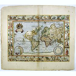
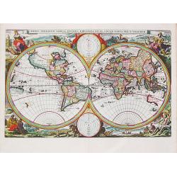
Nova Totius Terrarum Orbis Geographica...
A beautifully decorative world map taken from the 'English Atlas' by Moses Pitt and Steven Swart, based on an earlier engraved world map by Pieter van den Keere ca. 1630,...
Date: Oxford, 1680
Selling price: ????
Please login to see price!
Sold in 2016
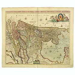
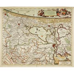
Comitatus Hollandiae. . .
Scarce Danckerts edition of this decorative map of the Netherlands. It includes decorative cartouche, compass rose, coat of arms, sailing ships, etc. Orientated west to t...
Date: Amsterdam, 1680
Selling price: ????
Please login to see price!
Sold in 2017
Novissima Islandiae Tabula. Sumptibus Janssonio - Waesbergiorum, Mosis Pitt et Stephani Swart.
A beautiful map of Iceland, embellished with cartouches, compass roses, rhumb lines, and many other decorative features. Moses Pitt and Steven Swart used the copper plate...
Date: Oxford, 1680
Selling price: ????
Please login to see price!
Sold in 2017
Typus Generalis Ukrainae sive Palatinatuum Podoliae, Kioviensis et Braczlaviensis terras nova delineatione exhibens. . .
Keymap based on Guillaume La Vasseur de Beauplan's map of the region published in "Description d'Ukraine." The work described Ukraine as several provinces of th...
Date: Oxford, 1680
Selling price: ????
Please login to see price!
Sold in 2020
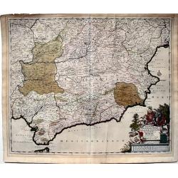
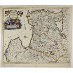
Regnorum Castellae, Novae, Andalujsae, Granadae, Valentae, et Murciae Accurata Tabula, in Episcopatus etc. divisa edita par Fredericum De Wit...
A very decorative, large, and accurate map of Southern Spain. It extends from Salamanca and Segovia in the north to the Gulfs of Valentia, Alicante and Cartgena in the ea...
Date: Amsterdam, 1680
Selling price: ????
Please login to see price!
Sold in 2023
Insula sive regnum Siciliae.
Extremely decorative, fine old color example of De Wit's rare map of Sicily. It shows in details the cities of Messina, Milazzo, Palermo, Catania and Trapani.It is consid...
Date: Amsterdam, 1680
Selling price: ????
Please login to see price!
Sold in 2017
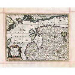
Nova Totius Livoniae accurata Descriptio.
Antique map of the Baltic States Estonia & Latvia
Date: Oxford, 1680
Selling price: ????
Please login to see price!
Sold in 2017
Orbis Terrarum Tabula Recens Emendata per N. Visscher.
The second state of the second map of the world in two hemispheres by Nicolas Visscher I in the series of world maps in Dutch bibles. Published by Nicolaes Visscher II (d...
Date: Amsterdam, 1680
Selling price: ????
Please login to see price!
Sold in 2018
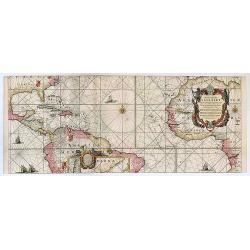
West-Indische Paskaert waer in de graden der breedde over weder zijden vande middellijn wassende so vergrooten dat die geproportioneert sijn tegen hunne nevenstaende graden de lengde.
This is the second state of Goos' version of the West Indische Paskaert, published by Johannes Van Keulen, first published circa 1680.This second state was issued both as...
Date: Amsterdam, 1680
Selling price: ????
Please login to see price!
Sold in 2017
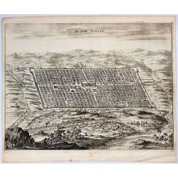
De Stadt Ninive.
A striking copper engraving providing a bird’s-eye view of the city and surrounding countryside of Ninive in Iraq. It is from Olfert Dapper's "De Stadt Ninive"...
Date: Amsterdam, 1680
Selling price: ????
Please login to see price!
Sold in 2019
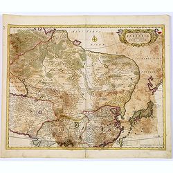
Tabula Tartariae et majoris partis regni Chinae.
Stretching from the Caspian Sea in the west to Formosa in the south-east. Including the peninsula of Korea, Japan, Taiwan and the east coast of Yedso. Decorated with fine...
Date: Amsterdam, 1680
Selling price: ????
Please login to see price!
Sold in 2018
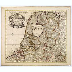
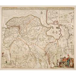
Belgium Foederatum emenate auctum et novissime editum.
A beautiful detailed map of the area of the modern Netherlands less the southern part of Limburg. The map is enhanced by a title cartouche representing the commerce, the ...
Date: Amsterdam, 1680
Selling price: ????
Please login to see price!
Sold in 2018
Insula sive regnum Siciliae.
An extremely decorative, large, fine old color example of De Wit's rare map of Sicily. It shows in detail the cities of Messina, Milazzo, Palermo, Catania and Trapani.It ...
Date: Amsterdam, 1680
Selling price: ????
Please login to see price!
Sold in 2019
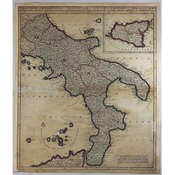
Regnum Neapolis Sisiliae et Lipariae Insulae.
A detailed map of the southern part of Italy, with a large inset of Sicily. Extends north to include Aprutium Ulterius (Aquila). Some major cities shown include; Napoli, ...
Date: Amsterdam, 1680
Selling price: ????
Please login to see price!
Sold in 2018
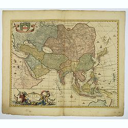
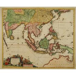
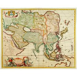
Asiae Nova Delineatio.
A superb map of the whole of Asia and the East Indies. The discoveries of Tasman, Janszoon and Cartensz are reflected in Australia and New Guinea.The delineation of Japan...
Date: Amsterdam, 1680
Selling price: ????
Please login to see price!
Sold in 2018
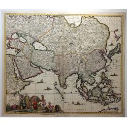
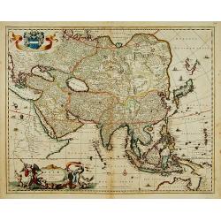
Accuratissima Totius Asiae Tabula. . .
A fine example of De Wit's map of Asia, featuring ornate cartouche with eight traders, two parrots, a camel and a monkey, together with five sailing ships, a compass rose...
Date: Amsterdam, ca. 1680
Selling price: ????
Please login to see price!
Sold in 2018
Ducatuum Lovoniae et Curlandiae Novissima Tabula in Quibus sunt Estonia ...
A rare and decorative map of Estonia, part of Latvia, Lithuania and Russia.
Date: Amsterdam, 1680
Selling price: ????
Please login to see price!
Sold in 2018
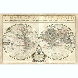
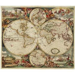
A Mapp of All The World.
An exceptional example of this very rare, separately published, beautifully adjusted map, highlighted with gold coloring. A fine engraved double-hemisphere map of the wor...
Date: London, 1680
Selling price: ????
Please login to see price!
Sold in 2019
![[Two title pages] Atlas Contractus sive Mapparum Geographicarum. . . / The English Atlas.](/uploads/cache/41703-250x250.jpg)
[Two title pages] Atlas Contractus sive Mapparum Geographicarum. . . / The English Atlas.
A pair of charming and decorative title pages. The first is from Schenk's Atlas Contractus sive Mapparum Geographicarum Sansoniarum auctarum et correctarum Nova Congeries...
Date: Amsterdam, 1700 / Oxford, 1680
Selling price: ????
Please login to see price!
Sold in 2018
Prussia Accurate Descripta.
As indicated in the title cartouche, the map was prepared by the German cartographer Gaspher Henneberg of Erlich. In a second cartouche it is dedicated to Dr.Nicolao van ...
Date: Oxford, ca 1680
Selling price: ????
Please login to see price!
Sold in 2020
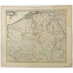
Belgii Regii Accuratissima Tabula Pluribus Locis. . .
Covering present-day Belgium, Luxembourg, Noord Brabant an Limburg in the Netherlands, and northern part of France.
Date: Amsterdam, 1680
Selling price: ????
Please login to see price!
Sold in 2023
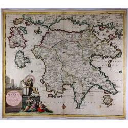
Peloponnesus Hodie Moreae Regnum.
A lovely map of the southern part of Greece / Peloponnese (Pelopónnisos) by Danckerts. With a beautifully colored cartouche with a Venetian Lion fighting against the Tur...
Date: Amsterdam, 1680
Selling price: ????
Please login to see price!
Sold in 2018
![[Lot of 3 maps] Uplandia, plus a map of the island of Ruegen by W, Blaeu and the General map of Scandinavia by Reinier & Joshua Ottens.](/uploads/cache/82017-250x250.jpg)
[Lot of 3 maps] Uplandia, plus a map of the island of Ruegen by W, Blaeu and the General map of Scandinavia by Reinier & Joshua Ottens.
An attractive map of Upland with Stockholm. With two nice cartouches. Moses Pitt (d.London,1696), planned to publish together with Janssonius' son-in-law, Janssonius van ...
Date: London, 1680
Selling price: ????
Please login to see price!
Sold in 2022
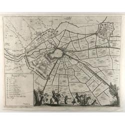
Bergue Ste. Vinox.
An interesting city map of Bergues, France by Bouttats in 1690. Featuring an aerial plan with its fortifications and surrounding landscape. A military-themed scene and a ...
Date: Antwerp, 1680
Selling price: ????
Please login to see price!
Sold in 2019
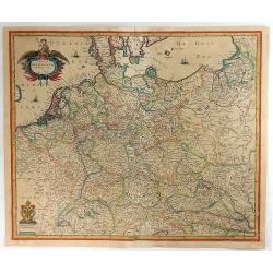
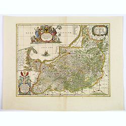
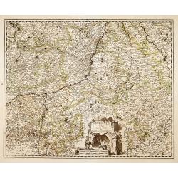
Tabula Germaniae Emendata Recens.
A lovely, detailed 1680 map of Germany, by Hugo Allard. The map covers present-day Germany, Netherlands, Luxembourg, Belgium, part of France, Austria, southern Denmark, ...
Date: Amsterdam, 1680
Selling price: ????
Please login to see price!
Sold in 2021
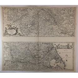
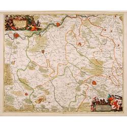
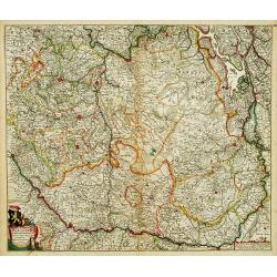
Totius Fluminis Rheni Novissima Descriptio. . .
Two maps on one sheet, one above the other, charting the course of the Rhine River., beginning on the top map, from its source at the Bodensee in Switzerland, through the...
Date: Amsterdam, 1680
Selling price: ????
Please login to see price!
Sold in 2018
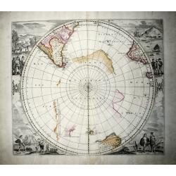
Polus Antarcticus (rare IV State).
A nice example of the rare De Wit edition of the famous, large hemispherical map of the Antarctic region, originally published by Hondius. In this edition the discoveries...
Date: Amsterdam, 1680
Selling price: ????
Please login to see price!
Sold in 2020
Pascaart vande Canaal, Engeland, Schotland, en Yrland.
A large nautical map of the complete British Isles, beautifully decorated with an elaborate title cartouche, coats of arms and compass roses. Lacking van Keulen’s privi...
Date: Amsterdam, before 1680
Selling price: ????
Please login to see price!
Sold in 2019
Route d' Osacca à Iedo / Route de Nangasacqui a Osacca.
A rare folio-sized copper engraving of Japan with the route from Osaka to Jedo (Tokyo) and the route from Nagasaki to Osaka. On the top map the details of the route from ...
Date: Amsterdam, 1680
Selling price: ????
Please login to see price!
Sold in 2021
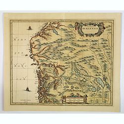
Episcopatus Bergensis.
An uncommon issue of Janssonius' map of the area around Bergen, in Norway, first issued in 1658. After Jansson's death in 1664 the plate came into the possession of his s...
Date: Oxford, ca 1680
Selling price: ????
Please login to see price!
Sold in 2019
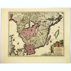
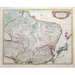
Regni Gothiae Tabula Generalis, in qua sont. . .
A striking map of southern Sweden, the islands of Gotland and Oland, a portion of northern Denmark, and Norway as far as Oslo by the Dutch cartographer and artist, Freder...
Date: Amsterdam, ca 1680
Selling price: ????
Please login to see price!
Sold in 2019
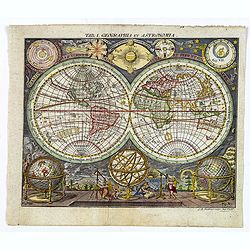
Tab. 1. Geographia et Astronomia.
A scarce first state map by L.M. Steinberger that was originally published in 1680, this wonderful double hemisphere map of the World shows California as an island, and a...
Date: Augsberg, ca 1680
Selling price: ????
Please login to see price!
Sold in 2019
![[No title] Spitzbergen.](/uploads/cache/02427-250x250.jpg)
[No title] Spitzbergen.
Greenland split in two and Wiches Lande at the edge of the map, complete with compass-rose, galleon and monsters. Surrounded by eleven scenes of whaling from capture to b...
Date: London 1680
Selling price: ????
Please login to see price!
Sold in 2020
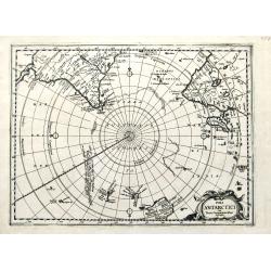
Poli Antarctici cum Terris Circumajacentibus descriptio.
A very rare map of the South Pole, showing outlines of the Antarctic continent, also parts of Australia and New Zealand. Some dates and notes of discoveries. A very unusu...
Date: ca 1680
Selling price: ????
Please login to see price!
Sold in 2019
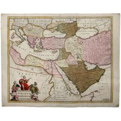
TURCICUM IMPERIUM.
A detailed map of the Turkish Empire by Holland's leading mapmaker at the end of the seventeenth century. The cartouche shows an Ottoman administrator ,or possibly the S...
Date: Amsterdam, 1680
Selling price: ????
Please login to see price!
Sold in 2019
LA FLORIDE
Map of Florida, from the atlas L'Amérique en plusieurs cartes, et en divers traittés de Géographie, et d'Histoire.Nicolas Sanson was to bring about the rise of French ...
Date: Paris 1680
Selling price: ????
Please login to see price!
Sold in 2019
Insula Matanino vulgo Martanico in lucem edita / per Nicolaum Visscher cum Priviliegio Ordin: General Belgii Faederati.
Uncommon map, showing the portion of the island which had been taken from the Caribs up to that time. In lower left corner a title cartouche with fruit, tobacco, sugar.
Date: Amsterdam, ca. 1680
Selling price: ????
Please login to see price!
Sold in 2019
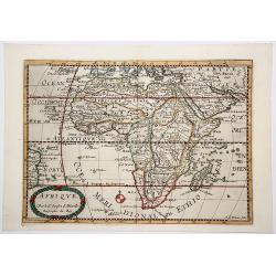
AFRIQUE.
Decorative, engraved map of Africa that includes Arabia and the Canary and Cape Verde Islands as well as several other Atlantic islands and the coastline of Brazil. Also ...
Date: Paris, ca. 1680
Selling price: ????
Please login to see price!
Sold in 2019
Tabula Tartariae et majoris partis Regnis Chinae.
A very decorative early map extending from the Caspian Sea until Japan, including China and Formosa. With a curious shape of eastern Russia without Kamchatka. Yedso is sh...
Date: Amsterdam, ca 1680
Selling price: ????
Please login to see price!
Sold in 2019
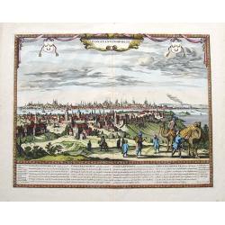
Constantinopolis.
An extremely rare panoramic town-view of Constantinople in Turkey, published by Frederick de Wit. In stunning colors and condition! Text in Latin, French, German, and Eng...
Date: Amsterdam, ca 1680
Selling price: ????
Please login to see price!
Sold in 2020
![[Title page] Atlas Tot Amsterdam Bij Iustus Danckers in de Calverstraet inde Damcbaerhrijt.](/uploads/cache/47920-250x250.jpg)
[Title page] Atlas Tot Amsterdam Bij Iustus Danckers in de Calverstraet inde Damcbaerhrijt.
Decorative title page with the figure of Atlas, standing on a globe of the Old World. The left and bottom right corners have animals and people from different parts of th...
Date: Amsterdam, ca. 1680
Selling price: ????
Please login to see price!
Sold in 2024
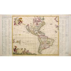
Novissima et Accuratissima Totius Americae descriptio..
One of the classic Dutch maps of the Americas and one of the most often copied.On either side of the map are tables listing the Cities, keyed to the map. Lower right hand...
Date: Amsterdam 1680
Selling price: ????
Please login to see price!
Sold
Lovaniensis Tetrarchia una cum Arscotano Ducatu. . .
Decorative map centred on Tienen and Leuven. Also including the towns of Mechelen, Namen, Landen, Leeuw, Aarschot, etc.
Date: Amsterdam, 1680
Selling price: ????
Please login to see price!
Sold in 2018
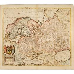
Novissima Russiae Tabula.
Detailed map of Russia including Scandinavia. Very decorative title cartouche with Russian coat-of-arms. Prepared by Isaac Masso.
Date: Amsterdam 1680
Selling price: ????
Please login to see price!
Sold
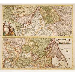
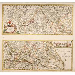
Totius Fluminis Rheni Novissima Descriptio..
Two maps on one sheet each map measuring 230x515mm. Showing the river Rhine from Boden See till the Netherlands.Two very fine cartouches.
Date: Amsterdam 1680
Selling price: ????
Please login to see price!
Sold
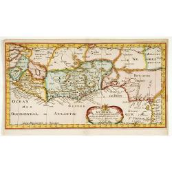
Guinee en de omliggende Landen.
A map of the lands along the Gulf of Guinea.
Date: Utrecht, 1680
Selling price: ????
Please login to see price!
Sold in 2022
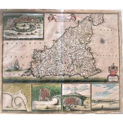
Limburgi Ducatus et Comitatus Valkenburgi. . .
The map describes the southern part of Limburg and reaches into Belgium (Liege, Verviers) and Germany (Aachen). It has two very decorative cartouches.
Date: Amsterdam, 1680
Selling price: ????
Please login to see price!
Sold in 2018
Leodiensis episcopatus..
Map centred on Liege. Covering the area between Antwerp, Turnhout, Roermond, Cologne, Trier and Dinant.
Date: Amsterdam 1680
Selling price: ????
Please login to see price!
Sold
![[Untitled manuscript chart of the South China Sea]](/uploads/cache/15747-250x250.jpg)
[Untitled manuscript chart of the South China Sea]
A rare example of a manuscript sea chart from the Thames School, with intriguing early annotations. The chart shows southern Formosa, the south coast of China, Indochina,...
Date: England, circa1680
Selling price: ????
Please login to see price!
Sold
Totius Fluminis Rheni.
Two maps on one sheet each map measuring 230x530mm.
Date: Amsterdam 1680
Selling price: ????
Please login to see price!
Sold
Rhenolandia, Amstelandia..
West to the top. Including towns of Amsterdam, Weesp, Gouda, Den Haag and Leiden. Very decorative title cartouche with dedication to Johan Hudde, senator of Amsterdam.
Date: Amsterdam 1680
Selling price: ????
Please login to see price!
Sold
Tabulae Dominii Groeningae..Partem Drentiae..
A fine engraved 17th century map of Groningen. Decorative title cartouche surmounted by coat of arms and two figures. Title cartouche with putti, figure and animals. Comp...
Date: Amsterdam 1680
Selling price: ????
Please login to see price!
Sold
Nova Totius Terrarum Orbis Tabula..
Sometime after 1684, when a privilege was granted to the Danckerts firm, a new plate was engraved to replace the single-sheet world map of 1680. The outer decoration is v...
Date: Amsterdam 1680
Selling price: ????
Please login to see price!
Sold
Indiae Orientalis nec non Insularum adiacentium.
Decorative map extending from India in the west, southern Japan in the north and the north coast of Australia is shown at bottom right with some coastal names till Cape Y...
Date: Amsterdam 1680
Selling price: ????
Please login to see price!
Sold
Peloponnesus Hodie Moreae regnum..
Decorative map of the Greece island Peloponnesus.Unfortunately with some holes and browning. Can be restored.Sold as is.
Date: Amsterdam 1680
Selling price: ????
Please login to see price!
Sold
"Le Comté d'Artois et des Environs ou l'on voit le.."
Including the towns of d'Abbeville, Arras, Bapaume, Douai, Valenciennes, Mons, etc.
Date: Amsterdam 1680
Selling price: ????
Please login to see price!
Sold
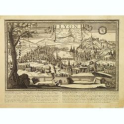
Lyon.
Very rare panoramic view of the town of Lyon. Underneath an historical description of the town in French and Latin. In top a inset map of the region.
Date: Paris, 1680
Selling price: ????
Please login to see price!
Sold in 2009
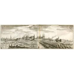
Chur. Fürstl. Resi. St. Berlin v Cöln.
Panorama view of Berlin.
Date: Frankfurt, 1680
Selling price: ????
Please login to see price!
Sold in 2010
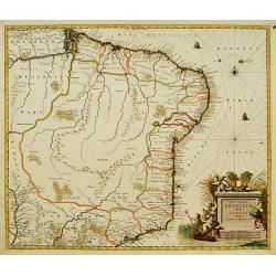
Nova et Accurata Brasiliae totius tabula.
The map Nova Brasiliae Typus was published by Willem Blaeu in his atlas Appendix in 1630. In 1642 a new, updated map Nova et Accurata Brasiliae with a much more detailed ...
Date: Amsterdam 1680
Selling price: ????
Please login to see price!
Sold
Ducatus Brabantiae Continens Marchionatum Sacri Imperii..
Shows present-day Belgium and Dutch province of Brabant. Including the Maas and Waal rivers. Shows Antwerp, Brussels, Namur, Liege and Venlo among other towns and cities....
Date: Amsterdam 1680
Selling price: ????
Please login to see price!
Sold
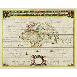
Orbis Terrarum Veteribus Cogniti Typus Geographicus
A classic map of the ancient world based on Ortelius. Europe, Asia and Africa as far south as Madagascar are placed at the center of a much larger oval frame. The Climati...
Date: Amsterdam 1680
Selling price: ????
Please login to see price!
Sold
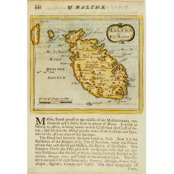
Maltha by Rob. Morden.
Fine map of Maltha and Gozo.
Date: London, 1680
Selling price: ????
Please login to see price!
Sold
Asiae nova delineato.
A detailed map of Asia. Very decorative title cartouche on the lower left corner. With dedication to Hendrik de Winter.
Date: Amsterdam 1680
Selling price: ????
Please login to see price!
Sold
Asiae nova delineato.
A detailed map of Asia. Very decorative title cartouche on the lower left corner. With privilege.
Date: Amsterdam 1680
Selling price: ????
Please login to see price!
Sold
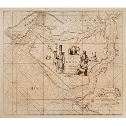
Paskaart van de Rivier de Dwina of Archangel..
Very decorative sea-chart of the River Dwina. Decorated with two large title-cartouches. Number 35 in lower right corner.
Date: Amsterdam 1680
Selling price: ????
Please login to see price!
Sold
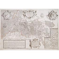
Romani Imperii Imago.
Copied after a map by Ortelius but much rarer.The medallion portraits are of Romulus and Remus -the genealogical 'tree' describes the lineage of the Roman emperors while ...
Date: Paris 1680
Selling price: ????
Please login to see price!
Sold
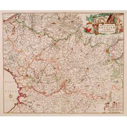
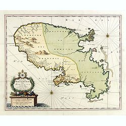
Tabula comitatus ARTESIAE emendata. A. Frederico de Wit.
A fine early engraved map of the region, embellished with two decorative cartouches.
Date: Amsterdam , ca. 1680
Selling price: ????
Please login to see price!
Sold
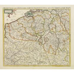
Belgii Regii Accuratissima Tabula Pluribus Locis...
Covering present-day Belgium, Luxembourg, Noord Brabant an Limburg in the Netherlands, and northern part of France.
Date: Amsterdam 1680
Selling price: ????
Please login to see price!
Sold in 2022
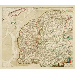
Tabula Comitatus Frisiae.
The map was prepared by B.Schotanus à Steringa.
Date: Amsterdam 1680
Selling price: ????
Please login to see price!
Sold
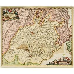
Ultraiectini Dominii Tabula..
Orientated south to the top. With two very decorative cartouches etched by Mr. Romeijn de Hooghe.
Date: Amsterdam, 1680
Selling price: ????
Please login to see price!
Sold in 2008
Sinus Gangeticus vulgo Golfo de Bengala Nova descriptio.
Showing the east coast of India and Sri Lanka. West to the top.
Date: Amsterdam 1680
Selling price: ????
Please login to see price!
Sold
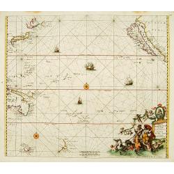
Magnum Mare del Zur.
Based on Goos' 1666 map, California depicted with an indented northern coastline following the second Sanson model. Tasmania, NW Australia and Carpentaria appear, as does...
Date: Amsterdam 1680
Selling price: ????
Please login to see price!
Sold
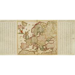
Nova et Accurate.. Europae descriptio..
One of the classic Dutch maps of Europe.On either side of the map are tables listing the Cities, keyed to the map. Lower right hand corner t' Amsterdam, By Frederick de W...
Date: Amsterdam 1680
Selling price: ????
Please login to see price!
Sold