Browse Listings
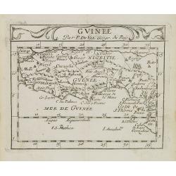
Guinee.
Uncommon miniature map of Guinea and Africa's Gold coast from Pierre Duval's La Geographie Universeille dated 1676. Following his Cartes de geographie in 1657, Pierre Duv...
Date: Paris, 1676
Selling price: ????
Please login to see price!
Sold in 2009
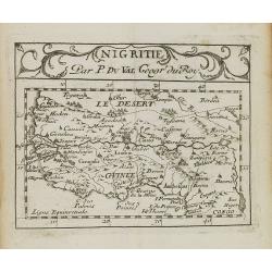
Nigritie.
Uncommon miniature map of Guinea and Africa's Gold Coast, from Pierre Duval's La Geographie Universeille dated 1676. Following his Cartes de geographie in 1657, Pierre Du...
Date: Paris, 1676
Selling price: ????
Please login to see price!
Sold in 2009
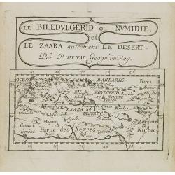
Le Biledulgerid ou Numidie et le Zaara autrement le Desert.
Uncommon miniature map of Sahara Dessert and Algeria, from Pierre Duval's La Geographie Universeille dated 1676. Following his Cartes de geographie in 1657, Pierre Duval ...
Date: Paris, 1676
Selling price: ????
Please login to see price!
Sold in 2009
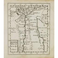
Egypte.
Uncommon miniature map of Egypt, from Pierre Duval's La Geographie Universeille dated 1676. Following his Cartes de geographie in 1657, Pierre Duval published this smalle...
Date: Paris, 1676
Selling price: ????
Please login to see price!
Sold in 2010
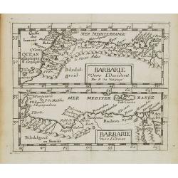
Barbarie vers L'Occident/Barbarie Vers L'Orient.
Two uncommon miniature maps of the western and eastern African coast from Morocco till Egypt from Pierre Duval's La Geographie Universeille dated 1676. Following his Cart...
Date: Paris, 1676
Selling price: ????
Please login to see price!
Sold in 2009
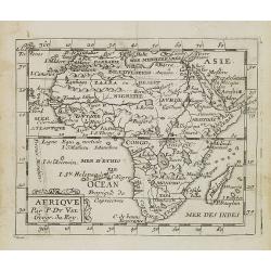
Afrique.
Uncommon miniature map of Africa from Pierre Duval's La Geographie Universeille dated 1676. Following his Cartes de geographie in 1657, Pierre Duval published this smalle...
Date: Paris, 1676
Selling price: ????
Please login to see price!
Sold in 2008
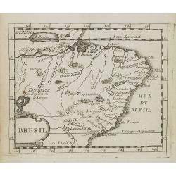
Bresil.
Uncommon miniature map of Brazil from Pierre Duval's La Geographie Universeille dated 1676. Following his Cartes de geographie in 1657, Pierre Duval published this smalle...
Date: Paris, 1676
Selling price: ????
Please login to see price!
Sold in 2008
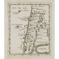
Chili.
Uncommon miniature map of Chile from Pierre Duval's La Geographie Universeille dated 1676. Following his Cartes de geographie in 1657, Pierre Duval published this smaller...
Date: Paris, 1676
Selling price: ????
Please login to see price!
Sold in 2008
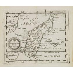
Isle de Madagascar dite de St.Laurens et aujourd'hui Isle Dauphine.
Uncommon miniature map of Madagascar from Pierre Duval's La Geographie Universeille dated 1676. Following his Cartes de geographie in 1657, Pierre Duval published this sm...
Date: Paris, 1676
Selling price: ????
Please login to see price!
Sold in 2008
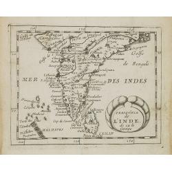
Presqu''isle de L'Inde de ça le Gange.
Uncommon miniature map of India from Pierre Duval's La Geographie Universeille dated 1676. Following his Cartes de geographie in 1657, Pierre Duval published this smaller...
Date: Paris, 1676
Selling price: ????
Please login to see price!
Sold in 2008
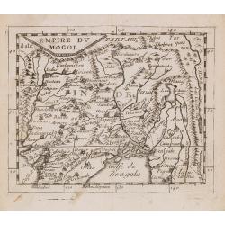
Empire du Mogol.
Uncommon miniature map of the Mongol empire from Pierre Duval's La Geographie Universeille dated 1676. Following his Cartes de geographie in 1657, Pierre Duval published ...
Date: Paris, 1676
Selling price: ????
Please login to see price!
Sold in 2008
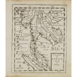
Presqu''isle de L'Inde de ça le Gange.
Uncommon miniature map of India from Pierre Duval's La Geographie Universeille dated 1676. Following his Cartes de geographie in 1657, Pierre Duval published this smaller...
Date: Paris, 1676
Selling price: ????
Please login to see price!
Sold in 2008
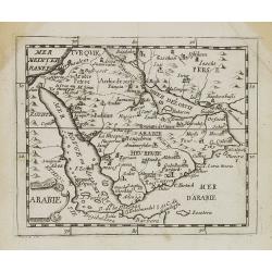
Arabie.
Uncommon miniature map of the Arabian peninsular, from Pierre Duval's La Geographie Universeille dated 1676. Following his Cartes de géographie in 1657, Pierre Duval pub...
Date: Paris, 1676
Selling price: ????
Please login to see price!
Sold in 2008
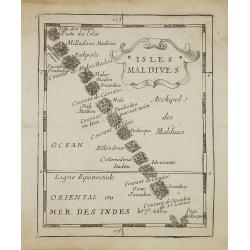
Isles Maldives.
Uncommon miniature map of the Maldives Islands from Pierre Duval\'s La Geographie Universeille dated 1676. Following his Cartes de géographie in 1657, Pierre Duval publi...
Date: Paris, 1676
Selling price: ????
Please login to see price!
Sold in 2008
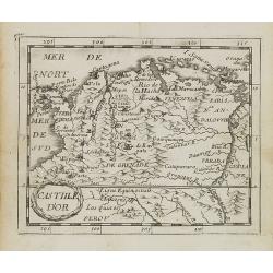
Castille d\'Or.
Uncommon miniature map of Columbia from Pierre Duval\'s La Geographie Universeille dated 1676. Following his Cartes de géographie in 1657, Pierre Duval published this sm...
Date: Paris, 1676
Selling price: ????
Please login to see price!
Sold in 2008

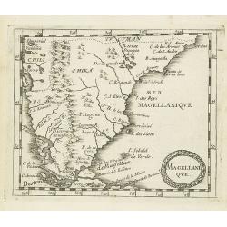
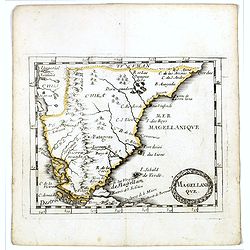
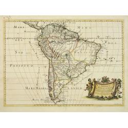
Magellanique.
Uncommon miniature map of Magellan strait and the southern tip of Latin America from Pierre Duval's La Geographie Universeille. Ferdinand Magellan sailed through the stra...
Date: Paris, 1676
Selling price: ????
Please login to see price!
Sold in 2008
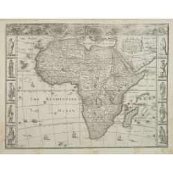
Africae, Described. The manners of their Habits and buildings newly done into English?
A third state of the first English map of the continent of Africa. From the first world atlas produced in England, Speed\'s map of the whole continent is a typically deco...
Date: London, 1627 -1676
Selling price: ????
Please login to see price!
Sold in 2009
Magellanique.
Uncommon miniature map of Magellan strait and the southern tip of Latin America from Pierre Duval's La Geographie Universeille. Ferdinand Magellan sailed through the stra...
Date: Paris, 1676
Selling price: ????
Please login to see price!
Sold in 2011
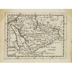
Arabie.
Uncommon miniature map of the Arabian peninsula, from Pierre Duval's La Geographie Universeille dated 1676. Following his Cartes de géographie in 1657, Pierre Duval publ...
Date: Paris, 1676
Selling price: ????
Please login to see price!
Sold in 2017
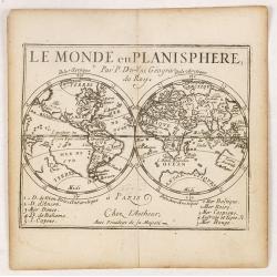
Le Monde en Planisphere. . .
Uncommon miniature map of the World showing California as an island, from Pierre Duval's La Geographie Universeille dated 1676. Following his Cartes de geographie in 1657...
Date: Paris, 1676
Selling price: ????
Please login to see price!
Sold in 2020
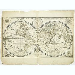
Planisphere, ou Carte Generale du Monde.
Third State, dated 1676. Engraved by Louis Cordier. The two hemispheres generally follow Sanson's latest world map of 1660 except for the unusual, and less accurate, repr...
Date: Paris, 1676
Selling price: ????
Please login to see price!
Sold
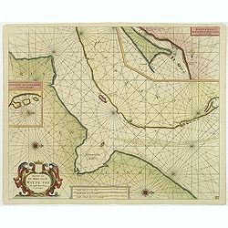
Pascaerte van de Mont van de Witte Zee tot aen de Rivier van Archangel..
Beautiful and rare chart from Nieuw en Groote Loots-Man Zee Spiegel, Ofte lichtende Colomme. Showing the mount of the White Sea. In upper right hand corner inset map of &...
Date: Amsterdam, 1676
Selling price: ????
Please login to see price!
Sold in 2011
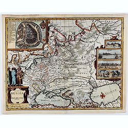
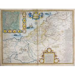
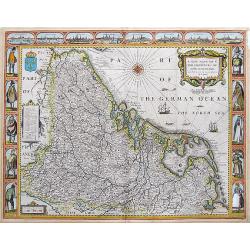
A map of RUSSIA.
A good impression from an early edition of this famous and decorative cartes-a-figures of Russia from the first world atlas produced by an Englishman - John Speed’s Pro...
Date: London 1676
Selling price: ????
Please login to see price!
Sold in 2021
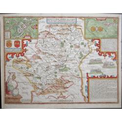
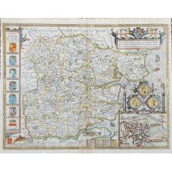
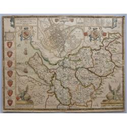
'Hartford Shire described, The situations of Hartford and the most ancient towne S.Albons with such memorable actions as have happened'
Full title as it appears at the top of the map: 'Hartford Shire described, The situations of Hartford and the most ancient towne S.Albons with such memorable actions as h...
Date: London, 1676
Selling price: ????
Please login to see price!
Sold in 2020
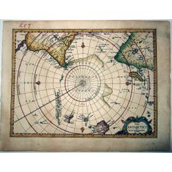
POLI ANTARCTICI Cum Terris Circumjacentibus Descriptio.
An extremely rare map of the Antarctic region, including most of (then known) Australia and New Zealand, from the last, enlarged, edition of the Mercator / Cloppenburgh A...
Date: Amsterdam, 1676
Selling price: ????
Please login to see price!
Sold in 2021
![IAPONIA, Petrus Kaerius Coelavit [Korea as an Island].](/uploads/cache/85228-250x250.jpg)
IAPONIA, Petrus Kaerius Coelavit [Korea as an Island].
An extremely rare variant of the map of Japan and Korea, based on Jodocus Hondius' folio map of Japan. The map follows the Ortelius/Teixeira type for Japan, with Korea sh...
Date: Amsterdam,1676
Selling price: ????
Please login to see price!
Sold in 2021
![MAGELLAN STRAIT, TERRA DEL FUOGO [without title].](/uploads/cache/85229-250x250.jpg)
MAGELLAN STRAIT, TERRA DEL FUOGO [without title].
An extremely rare variant of the map of the Magellan Strait and Tierra del Fuego. Here erased are the jagged oceans and no text is printed on the verso. From the updated ...
Date: Amsterdam, 1676
Selling price: ????
Please login to see price!
Sold in 2021
![[Portrait of ] Theodorus de Bry Leodinensis . . .](/uploads/cache/47700-250x250.jpg)
[Portrait of ] Theodorus de Bry Leodinensis . . .
Half-length portrait of Theodorus de Bry standing and looking to right.Born in Liège in 1528, Théodore de Bry learned the art of printmaking from Albert Dürer. Protest...
Date: Germany, 1676
Selling price: ????
Please login to see price!
Sold in 2022
Essex, devided into Hundreds...
Speed's famous map of Essex. From London until Harwich. With an inset plan of Colchester. Richly decorated with coats of arms and seals, sailing ships, a sea-monster, and...
Date: London, 1676
Selling price: ????
Please login to see price!
Sold in 2023
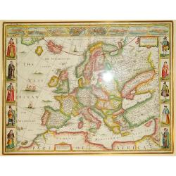
Europ, and the chiefe Cities contayned yjerin, described; with the habits of most Kingdoms now in use. By Jo. Speed Ano Dom 1626
An exceptional example of John Speed's sought-after map of Europe, bordered by images of various European ethnicities in traditional 17th century dress. Along the top por...
Date: London, ca. 1676
Selling price: ????
Please login to see price!
Sold in 2012
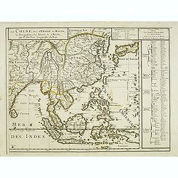
La Chine vaec l'Empire du Mogol. . .
Uncommon map the Far East including China, Korea, Japan, Indonesia with Philippines, etc.
Date: Paris, 1676
Selling price: ????
Please login to see price!
Sold in 2012
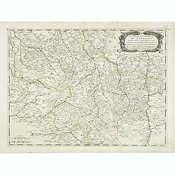
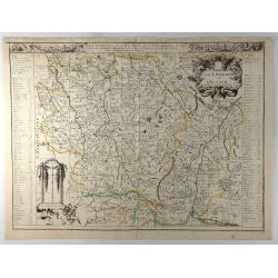
Gouvernement général du Lyonnois suivant les derniers Estats generaux ou sont le Lyonnois . . .
Fine map of central part of France centered on Clermont-Ferrand and with Lyon in the most eastern part of the map.This edition has no date and carries the address of Pier...
Date: Paris, 1676
Selling price: ????
Please login to see price!
Sold
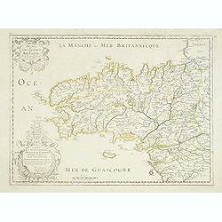
Duche et Gouvernement de Bretagne.
Fine map of Bretagne, including the cities of Nantes, Rennes, Belle-Île, etc. engraved by R. Cordier d'Abbauil. The map is still dated 1650. In the dedicational cartouch...
Date: Paris, 1676
Selling price: ????
Please login to see price!
Sold in 2012
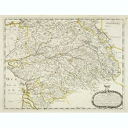
Gouvernement General d'Orleans . . .
Fine map of south eastern part of France, centered on the river Loire, including Isle d'Ré, S.Malo and Paris in the upper right corner. This edition carries the date 165...
Date: Paris, 1676
Selling price: ????
Please login to see price!
Sold in 2012
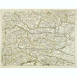
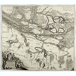
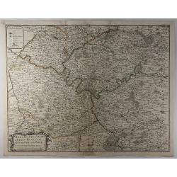
Le Cours du Danube ou sont la Baviere, l'Austriche et la Boheme. . .
A detailed and scarce map showing the river Danube from Hungary until its source in Germany. In lower part the Gulf of Trieste with Venice.
Date: Paris, 1676
Selling price: ????
Please login to see price!
Sold in 2013
![L'Italie par P. Du-Val. . . [4 sheet wall map]](/uploads/cache/31972-250x250.jpg)
L'Italie par P. Du-Val. . . [4 sheet wall map]
One of Du Vals magnificent wall maps included in his atlas "Cartes de Geographie" and could be mounted and used as a wall map.Dated 1675. Engraved by Francois C...
Date: Paris, 1675-1676
Selling price: ????
Please login to see price!
Sold
![[Title page] Cartes de geographie les plus nouvelles et les plus fideles, Avecque leurs divisions regulieres, par P. Du Val Géographe Ordinaire du Roy.](/uploads/cache/31992-250x250.jpg)
[Title page] Cartes de geographie les plus nouvelles et les plus fideles, Avecque leurs divisions regulieres, par P. Du Val Géographe Ordinaire du Roy.
Title page with un until yet unknown date "1676" from the atlas "Cartes de geographie les plus nouvelles et les plus fideles, Avecque leurs divisions regul...
Date: Paris, 1676
Selling price: ????
Please login to see price!
Sold in 2012
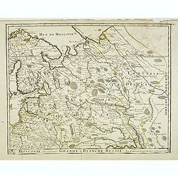
Moscovie dîte autrement la Grande Blanche Russie . . .
Detailed map by Pierre du Val of the European part of Russia including Finland, Poland and the Baltics with title along the bottom.This is the uncommon early edition with...
Date: Paris, 1676
Selling price: ????
Please login to see price!
Sold in 2014
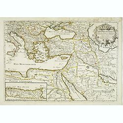
L'empire des Turcs, en Europe, en Asie, et en Afrique, avec les principales routes qu'y tiennent les Caravanes . . .
Scarce map of Turkey widened to the Mediterranean basin with fine title cartouche upper right. Insert map of African coasts (85x193) with a descriptions of caravans main ...
Date: Paris, 1676
Selling price: ????
Please login to see price!
Sold in 2016
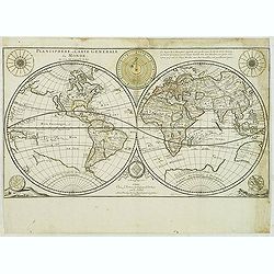
Planisphere, ou Carte Generale du Monde.
Third State, dated 1676. Engraved by Louis Cordier. The two hemispheres generally follow Sanson's latest world map of 1660 except for the unusual, and less accurate, repr...
Date: Paris, 1676
Selling price: ????
Please login to see price!
Sold
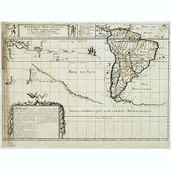
Amerique Meridionale, Par P. Du Val . . .
Map of the Southern Hemisphere showing South America, New Zealand, the southern coasts of Australia, and route of Le Maire across the Pacific. Published by P. Du-Val betw...
Date: Paris, 1676
Selling price: ????
Please login to see price!
Sold
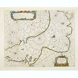
Pascaarte van de Witte Zee begrypende de custen van Laplant..
Beautiful chart of the White Sea from Nieuw en Groote Loots-Man Zee Spiegel, Ofte lichtende Colomme. Showing the White Sea.The family name of the Lootsman brothers is The...
Date: Amsterdam, 1676
Selling price: ????
Please login to see price!
Sold in 2012
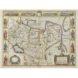
A newe map of Tartary.
One of the most decorative "carte à figures"- maps of Tartary, known for its figured borders with costume figures, while above are vignettes of the cities of A...
Date: London, 1626-1676
Selling price: ????
Please login to see price!
Sold in 2013
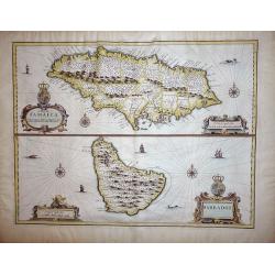
A Map of Jamaica & Barbados.
A Map of Jamaica and Barbados on one sheet,both with elaborate strapwork cartouches and mileage scales, compass roses and numerous rhumb lines. This is one of the new map...
Date: London, 1676
Selling price: ????
Please login to see price!
Sold in 2012
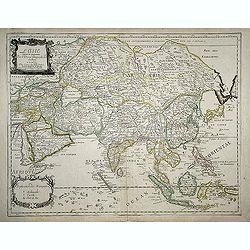
L\'Asie reueuë et augmenteé. Par P.Duval. . .
Scarce map of Asia. A handsome production: title with finely engraved ornamentation. This map reflects the extent of European missionary activity in Asia: the key at the ...
Date: Paris, 1676
Selling price: ????
Please login to see price!
Sold in 2013
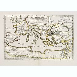
Patriarchatus, Romanus, Constantinopolitanus, Alexandrinus, Antiochenus, et Hierosolimitanus. . .
Map of the Roman Empire with large territorial holdings around the Mediterranean in Europe, Africa, and Asia. The first two centuries of the Empire were a period of unpre...
Date: Paris, 1675-1676
Selling price: ????
Please login to see price!
Sold in 2017
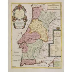
Royaume de Portugal.
From his first edition of his only folio atlas. Engraved by N.Michu.Uncommon map of Portugal, with fine title cartouche upper left and to the right a list of the Portugue...
Date: Paris 1676
Selling price: ????
Please login to see price!
Sold in 2013
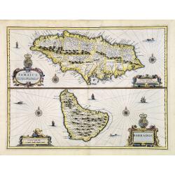
A Map of Jamaica & Barbados.
A Map of Jamaica and Barbados on one sheet, both with elaborate strapwork cartouches and mileage scales, compass roses and numerous rhumb lines. This is one of the new ma...
Date: London, 1676
Selling price: ????
Please login to see price!
Sold in 2013
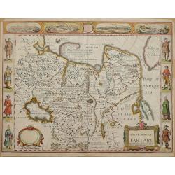
A Newe Mape of Tartary by John Speed.
Map of the Russian Empire, engraved by Dirck Gryp for Speed's 'Prospect of the… World'Carte-a-figure map of Asia from Moscow in the west to the Pacific Ocean in the eas...
Date: London, Basset & Chiswell, 1676
Selling price: ????
Please login to see price!
Sold in 2014
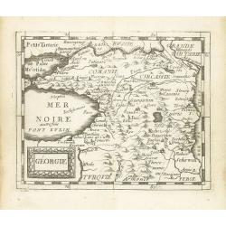
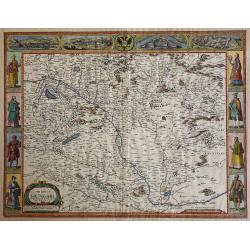
Géorgie.
Scarce miniature map of Georgia from Pierre Duval's La Geographie Universeille dated 1676. Following his Cartes de geographie in 1657, Pierre Duval published this smaller...
Date: Paris, 1676
Selling price: ????
Please login to see price!
Sold in 2015
Canaan - Jerusalem Anno Domini 1651.
Shows part of Egypt, the Sinai Peninsula, and Palestine on both sides of the Jordan, divided among the Tribes of Israel. The shore line runs from "Biblus" in th...
Date: London, Basset & Chriswell, 1651-1676
Selling price: ????
Please login to see price!
Sold in 2014
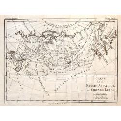
Carte de la Russie Asiatique ou Tartarie Russe.
Fine copper engraved engraving featuring the Eastern part of Russia. Engraved by Brion de la Tour and published in "HISTOIRE UNIVERSELL" by Chez Moutard in 1676...
Date: Paris, 1676
Selling price: ????
Please login to see price!
Sold in 2014
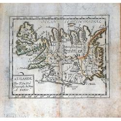
L'Islande par P. Du Val Geographe du Roy a Paris.
A nice, rare miniature map of Iceland from Pierre Duval's "La Geographie Universeille". Duval published a very small sized atlas containing a large number of ma...
Date: Paris, 1676
Selling price: ????
Please login to see price!
Sold in 2016
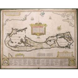
Aestivarum Insularum alias Bermudas...
This beautiful map was compiled in 1622 by Richard Norwood. It’s the first English printed map published in an atlas to show Bermuda divided into Tribes and Shares. The...
Date: London, 1676
Selling price: ????
Please login to see price!
Sold in 2016
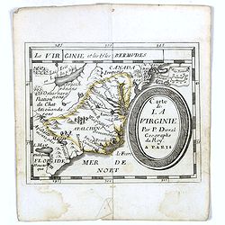
Carte de La Virginie.
Uncommon miniature map of Virginia from Pierre Duval's La Geographie Universeille dated 1676. It depicts the now defeated Swedish colony, and the inactive French claim of...
Date: Paris, 1676
Selling price: ????
Please login to see price!
Sold
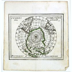
Terres Antarctiques .. Australes et Inconnues.
Uncommon miniature map of the South Pole, including Australia, New Zealand, southern tips of Africa and America. From Pierre Duval's La Geographie Universeille dated 1676...
Date: Paris, 1676
Selling price: ????
Please login to see price!
Sold in 2016
Magellanique.
Uncommon miniature map of Magellan strait and the southern tip of Latin America from Pierre Duval's La Geographie Universeille. Ferdinand Magellan sailed through the stra...
Date: Paris, 1676
Selling price: ????
Please login to see price!
Sold in 2016
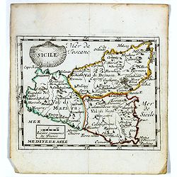
Sicile.
Scarce miniature map of Sicily from Pierre Duval's La Geographie Universeille. Following his Cartes de géographie in 1657, Pierre Duval published this smaller size atlas...
Date: Paris, 1676
Selling price: ????
Please login to see price!
Sold in 2020
Delineationem Liberae in silesia dynastiae Drachenberg . . .
Scarce map by Johann Christian Berger, of the Barony of Żmigród (=Drachenberg) with nearby fortress and sizable baroque garden, both surrounded by waters of Bar...
Date: Amsterdam, 1676
Selling price: ????
Please login to see price!
Sold in 2017
![[untitled] Sicily.](/uploads/cache/98041-250x250.jpg)
[untitled] Sicily.
Rare map of ancient Sicily from Raleigh's History of the World. The double page map shows the island in a large scale and good detail. Shows a number of towns, rivers and...
Date: London, 1614-1676
Selling price: ????
Please login to see price!
Sold in 2017
A New Mape of ye XVII Provinces of Low Germanie, mended a New in manie places.
Fantastic and important Carte-à-figures map of the Low Countries. With eight city views showing Amsterdam, Antwerp, Ghent, Middelburg, Groeningen, Zutphen, Utrectht and ...
Date: London, 1676
Selling price: ????
Please login to see price!
Sold in 2017
The Countye Palatine with the most ancient citie described.
The excellent county map of Cheshire, first published in Speed's “Theatre of Empire” in 1611, this is the 1676 edition with the Bassett & Chiswell imprint. The ma...
Date: London, 1676
Selling price: ????
Please login to see price!
Sold in 2020
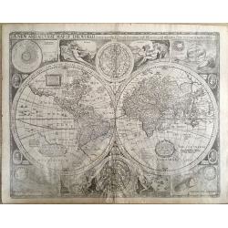
A New and Accurat Map of the World Drawne According to ye Truest Descriptions Latest Discoveries & Best Observations yt Have Beene Made by English or Strangers
This desirable and beautiful double-hemispheric world map carries the imprint of Bassett & Chiswell. The map is dated 1651 but it was known to be published in 1676 wi...
Date: London, 1676
Selling price: ????
Please login to see price!
Sold in 2018
La Lorraine et l'Alsace.
A detailed 1676 copper engraved map of the French wine-making region of Lorraine and Alsace by Du Val. It covers the northeast portion of France along with parts of neigh...
Date: Paris, 1676
Selling price: ????
Please login to see price!
Sold in 2020
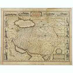
The Kingdome of Persia with the cheef Citties and Habites described.
John Speed's wonderful copperplate map of the Persian Kingdom, as it was towards the end of the seventeenth century. With a title cartouche, and eight side vignettes incl...
Date: London, 1676
Selling price: ????
Please login to see price!
Sold in 2019
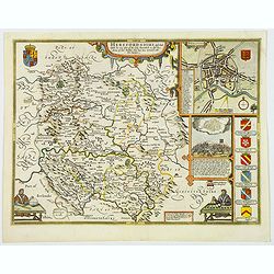
Herefordshire described. . .
The 1676 edition map of Herefordshire by John Speed, and published by Bassett & Chiswell in London. A decorative English county map, embellished with strapwork title ...
Date: London, 1676
Selling price: ????
Please login to see price!
Sold in 2020
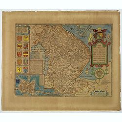
The Countie and Citie of Lyncolne. . .
John Speed's attractive map of Lincolnshire. Published at the back end of the seventeenth century by Basset & Chiswell in London. The left of the map features a town ...
Date: London, 1676
Selling price: ????
Please login to see price!
Sold in 2021
The Mape of Hungari newly augmented by John Speede.
A wonderful map of Hungary. Incorporated into Speed's 'Prospect Of The Most Famous Parts Of The World'. Showing 2 sets of 4 costumed figures on each side of the map and v...
Date: London, 1676
Selling price: ????
Please login to see price!
Sold in 2019
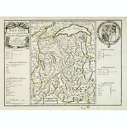
La Savoye divisée en ses Grandes Parties . . .
Detailed map of the province Savoie with fine title cartouche left and coat of arms to the right. Detailed key notions and fine arms right. More about [+]
Date: Paris, 1677
Selling price: ????
Please login to see price!
Sold
L'America Meridionale Nuovamente corretta et accresciuta . . .
Giacomo Giovanni Rossi's map of South America, based upon Sanson's map, but with revised Italian nomenclature. From his 'Mercurio Geografico'. The engraver was Giorgio Wi...
Date: Rome, 1677
Selling price: ????
Please login to see price!
Sold in 2012
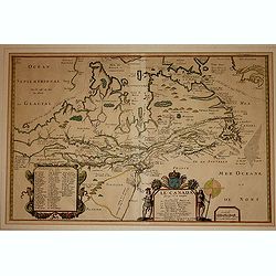
Le Canada faict par le St. de Champlain..
The fourth printed state of Champlain's 1616 plate of Canada. According to Wroth, Du Val somehow came into possession of the Champlain plate, printed a proof state, then ...
Date: Paris, 1677
Selling price: ????
Please login to see price!
Sold in 2012
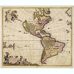
Novissima et Accuratissima Totius Americae Descriptio.
Second state of Visscher's map of the Americas, this decorative map greatly influenced the cartography of the Americas both geographically and artistically.Although it di...
Date: Amsterdam, 1677
Selling price: ????
Please login to see price!
Sold in 2013
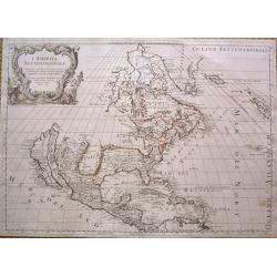
L'America Settentrionale.
Full title: 'L' America Settentrionale. Nuouamente corretta, et accresciuta secondo le relationi piu moderne, da GVGLIELMO SANSONE Geografe di S M Chrisftianis. E data in...
Date: Rome, 1677
Selling price: ????
Please login to see price!
Sold in 2015
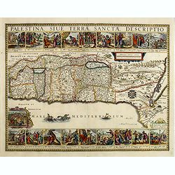
Palestina, Sive Terrae Sanctae Descriptio.
Oriented to the east, divided into the Tribes on both sides of the Jordan, the shoreline from Sidon to Alexandria. Along the top and the bottom 18 vignettes showing the E...
Date: Amsterdam, 1653-1677
Selling price: ????
Please login to see price!
Sold in 2014
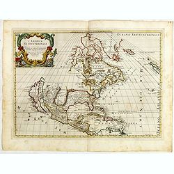
L' America Settentrionale. Nuouamente corretta, et accresciuta secondo le relationi piu moderne, da GVGLIELMO SANSONE. . .
Rossi's map of North America, based upon Sanson's seminal map, but with revised Italian nomenclature. Includes a detailed California as an Island on Sanson's model, and e...
Date: Rome, 1677
Selling price: ????
Please login to see price!
Sold in 2015
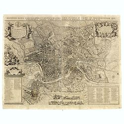
Recentis romae ichnographia et hypsographia. . .
A very rare bird's-eye-view of Rome, cartouches, inset illustrations of important churches and basilicas at foot. Engraved by Johan Meyer and published by Johannes Sandra...
Date: Nurenberg, 1677
Selling price: ????
Please login to see price!
Sold in 2016
Le Canada faict par le St. De Champlain. . .
This is the sixth and final printed state of Champlain’s 1616 plate of Canada issued by Pierre Du Val. The original 1616 Champlain map was never published, and only one...
Date: Paris, 1677
Selling price: ????
Please login to see price!
Sold in 2016
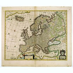
Europa Delineata et Recens Edita.
This map of Europe is particularly attractive: finely engraved with discreet decorative sailing ships, monsters and compass roses adorning the seas. Map is filled with pl...
Date: Amsterdam, 1677
Selling price: ????
Please login to see price!
Sold in 2017
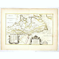
Duche D'Aiguillon.
A striking, unusual 1677 copper engraved regional map of France. Centred on the town of Aiguillon, the map covers the region of Lot-et-Garonne. The map provides excellent...
Date: Paris, 1677
Selling price: ????
Please login to see price!
Sold in 2019
L'Isle de France, le Valois, le Vexin-Francois, le Hurepoix et le Brie.
A highly detailed copper engraved map of the Île-de-France region of France. Centred on Paris, the map is filled with topographic details including cities, towns, villag...
Date: Paris, 1677
Selling price: ????
Please login to see price!
Sold in 2019