Browse Listings
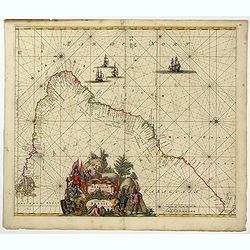
Littoria Brasiliae / Pascaert van Brasil.
A truly superb Dutch sea chart of Brazil, with north orientated to the left, published by Frederik de Wit, a man who was rightly famous for his accurate, detailed and hig...
Date: Amsterdam, ca 1675
Selling price: ????
Please login to see price!
Sold in 2022
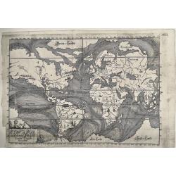
Die Ebbe und Fluth auff einer Flachen Landt-Karten Furgestelt
A very rare example of one of the first maps devoted to illustrate the world’s ocean currents, produced by Eberhard Werner Happel. The map also depicts volcanoes. It ...
Date: Ulm, 1675
Selling price: ????
Please login to see price!
Sold in 2022
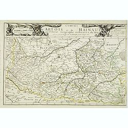
Comtes d'Artois et de Hainaut . . .
Detailed map of the northern part of France including the regions of Artois and Hainaut with the title along the top. Lille, Douai and Arras in the center.Dated 1675.More...
Date: Paris, 1675
Selling price: ????
Please login to see price!
Sold
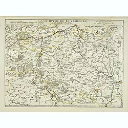
Le duche de Luxembourg et le comte de Namur . . .
The 1675 edition of the copperplate first issued in 1668. Detailed map of the duchy of Luxembourg and including the Belgium region Namur, with the title along the top.Dat...
Date: Paris, 1675
Selling price: ????
Please login to see price!
Sold in 2013
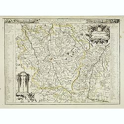
La lorraine et L'Alsace . . .
Detailed map of the French provinces Lorraine and Alsace with fine title cartouche upper right . To the left and right a key to the towns.More about [+]
Date: Paris, 1675
Selling price: ????
Please login to see price!
Sold
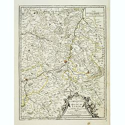
Le duché de Limbourg et l'Eveché de Liege . . .
Detailed map of the duchy of Limburg and diocese of Liege. With fine title cartouche lower right. Dated 1675.More about [+]
Date: Paris, 1675
Selling price: ????
Please login to see price!
Sold in 2019
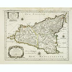
La Sicile, avec les anciens noms de presque toutes ses Places, Rivières, Chateaux &c. et diverses observations nouvelles . . .
Uncommon map of Sicily with fine title cartouche lower right . Dated 1675.More about [+]
Date: Paris, 1675
Selling price: ????
Please login to see price!
Sold in 2012
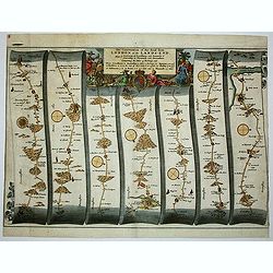
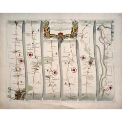
The Continuation of the Road from London to the Lands-end
This map is from John Ogilby's 'Britannia', published between 1675 and 1698. It is a landmark in the mapping of England and Wales. Its unique format constituted the first...
Date: London, 1675
Selling price: ????
Please login to see price!
Sold in 2012
![Orientaliora Indiarum Orientalium cum Insulis Adjacentibus a Promontorio C. Comorin ad Iapan. [together with] Occidentalior Tractus Indiarum Orientalium.](/uploads/cache/33091-250x250.jpg)
Orientaliora Indiarum Orientalium cum Insulis Adjacentibus a Promontorio C. Comorin ad Iapan. [together with] Occidentalior Tractus Indiarum Orientalium.
A matching set of two splendid sea charts covering the trading area of the Dutch V.O.C. and lavishly colored and hightened with gold by the Orientaliora Indiarum Oriental...
Date: Amsterdam, 1675
Selling price: ????
Please login to see price!
Sold
The Road from London to Harwich .
First edition. This strip map is from the "Britannia" by John Ogilby, published in 1675 identified by no sheet number. It is entitled " The Road from Londo...
Date: London, 1675
Selling price: ????
Please login to see price!
Sold in 2014
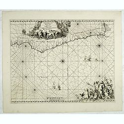
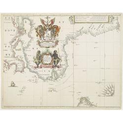
Cimbebas et Caffariae Littora a Catenbela ad Promontorium. . .
The coast of Angola, South-West Africa and South Africa up to Port Elizabeth. Classic sea of Dutch school with excellent baroque embellishment. North oriented to the lef...
Date: Amsterdam, 1675
Selling price: ????
Please login to see price!
Sold in 2014
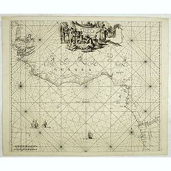
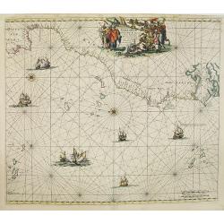
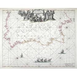
Tractus Littorales Guineae a Promontorio Verde. . .
The West coast of Africa from Mauritania up to Angola. Classic sea of Dutch school with excellent baroque embellishment. In top center a very decorative title cartouche.
Date: Amsterdam, 1675
Selling price: ????
Please login to see price!
Sold in 2014
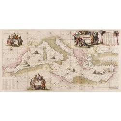
Orientalior tractus Maris Mediterranei. / Orientalior districtus Maris Mediterranei. . .
A fine copy of this beautiful of the Mediterranean lovely color. Centered on Italy, the north coast of Africa and part of the Black Sea. The entire sheet is covered with...
Date: Amsterdam, 1675
Selling price: ????
Please login to see price!
Sold in 2017
.Russiae et Novae Zemblae Maritimae.
This beautifully, large-scale chart, oriented with east at the top, displays the coastline from northern Russia. Covering the coast from Lapland till the west coast of No...
Date: Amsterdam, 1675
Selling price: ????
Please login to see price!
Sold in 2015
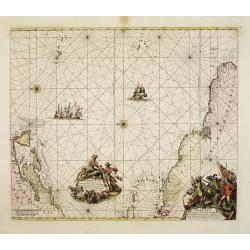
Occidentalior Tractus Indiarum Orientalium.
Decorative chart showing the coastlines of the Arabian peninsula with both the Red Sea and Persian Gulf shown in full. Africa from the Cape of Good Hope to Cape Comorin i...
Date: Amsterdam, 1675
Selling price: ????
Please login to see price!
Sold in 2018
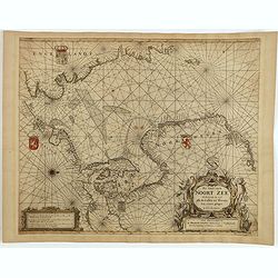
Pas Caart van de Noort Zee Verthoonende in zich alle de Custen en Havens daer rontom gelegen.
An eye-catching chart of the entirety of North Europe's coastline, extending from the Mouth of the Thames and the English Channel and Calais and Dunkirk to Stetin and Chr...
Date: Amsterdam, 1675
Selling price: ????
Please login to see price!
Sold in 2025
Collegium Orlielence (Oriel College)
From ”Oxonia Illustrata”, the first illustrated book on Oxford, and one of the major works of the 17th century.The book was the product of several years of devoted an...
Date: Oxford, 1675
Selling price: ????
Please login to see price!
Sold in 2019
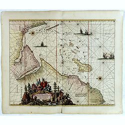
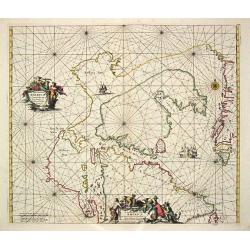
Terra Nova, ac Maris Tractus circa Novam Franciam, Angliam, Belgium, Venezuelam Novam Andalusiam, Guianam et Brasiliam...
A fantastic sea-chart showing the coastlines of North America, the West Indies, and the northern parts of Brazil. The chart extends from Newfoundland and the St Lawrence ...
Date: Amsterdam, 1675
Selling price: ????
Please login to see price!
Sold in 2019
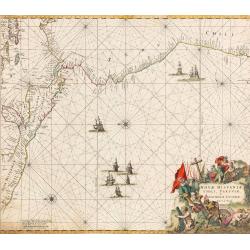
Nova Hispaniae, Chili, Peruviae, et Guatimalae Littorae...
An early edition of this superb chart of the Pacific Ocean, oriented with north to the left of the sheet, showing the coasts of Peru, Chili, Ecuador, Colombia, Honduras, ...
Date: Amsterdam, 1675
Selling price: ????
Please login to see price!
Sold in 2022
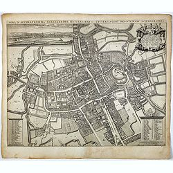
Nova & Accuratissima Celeberrimae Universitatis Civitatisque Oxoniensis Scenographia.
The most prominent historical map of Oxford by David Loggan (1634 - 1692), and has the added cache of having been printed in that city, drafted by a local resident. The m...
Date: Oxford, 1675
Selling price: ????
Please login to see price!
Sold in 2017
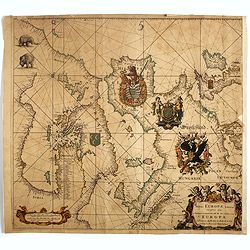
Totius Europae Littora Novissimè edita Pascaert vertoonende alle de See-custen van EUROPA. . .
This beautifully colored, large-scale , oriented with east at the top, displays Europe's coastline from northern Denmark, England to Yugoslavia in the south. A cleverly p...
Date: Amsterdam, 1675
Selling price: ????
Please login to see price!
Sold in 2017
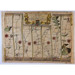
The Road from London To Montgomery North Wales. . .
A sheet showing part of the route from London to Montgomery in Worcestershire that includes the towns of Evesham, Worcester, Ludlow and Montgomery. Taken from John Ogilby...
Date: London, 1675
Selling price: ????
Please login to see price!
Sold in 2017
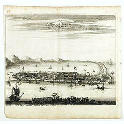
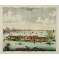
Vile et le chateu de Zélandia dans l' isle de Tayovan.
This important copperplate engraving is one of the earliest European views of Taiwan, depicting the Dutch fortifications and trading settlement on the West coast of the i...
Date: Amsterdam, 1675
Selling price: ????
Please login to see price!
Sold in 2020
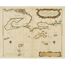
Paskaerte van 'T Eylandt Trinidad ..
An extremely rare and attractive chart of the islands of Trinidad, Margarieta, Granada, Tobago and The Dragon's Mouth between the islands and Venezuela. Upper left the mo...
Date: Amsterdam 1675
Selling price: ????
Please login to see price!
Sold
Carte vande Cust van Florida tot de Verginis streckende van Cabo de Carnaveral tot Baya de la Madalena.
An extremely rare and attractive chart of the coast of Florida extending from Cape Canaveral in Florida and following the coasts from South and North Carolina up to Cape ...
Date: Amsterdam 1675
Selling price: ????
Please login to see price!
Sold
The citie and Castle Zelandia in the Island of Taywan. / Stadt en casteel Zelandia op 't Eilant Taywan.
This important copperplate engraving is one of the earliest European views of Taiwan, depicting the Dutch fortifications and trading settlement on the West coast of the i...
Date: Amsterdam 1675
Selling price: ????
Please login to see price!
Sold
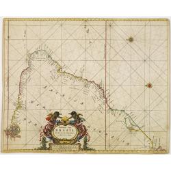
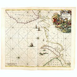
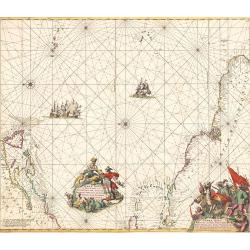
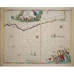
Paskaart van BRASIL van Rio de los Amazones, tot Rio de la Plata.
An eye-catching chart of Brazil. Including 2 compass roses along with a title cartouche.Pieter Goos (ca. 1616-1675) was one of the most important cartographer, engraver, ...
Date: Amsterdam 1675
Selling price: ????
Please login to see price!
Sold
Septentrionaliora Americae e Groenlandia per Fretus Davidis et Hudson, ad Terrum Novam.
The first state of Frederick de Wit's fine chart of Hudson Bay and Arctic Canada.Frederick de Wit (1610-1698) became after the closing of the Blaeu firm one of the most i...
Date: Amsterdam, 1675
Selling price: ????
Please login to see price!
Sold in 2020
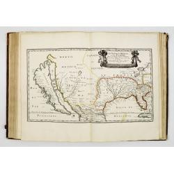
Cartes generales de la geographie ancienne et nouvelle ou les empires, monarchies, royaumes? Par les Sr. SANSON Geographes ordinaires de sa Majestè. TOME I. & II
The atlas has two printed title pages and two index sheets (the contents of the atlas does not correspond with the contents of the index sheets)Cartes generales de la geo...
Date: Paris Pierre Mariette, 1675
Selling price: ????
Please login to see price!
Sold
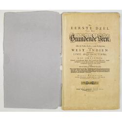
Het eerste deel van het Brandende Veen. . .
The text body of the extremely rare sea atlas by Arent Roggeveen, describing the American waters. The text pages have numerous figures of coastlines, plans, small town vi...
Date: Amsterdam, Pieter Goos, n.d. 1675 Amsterdam, Pieter Goos, n.d. 1675
Selling price: ????
Please login to see price!
Sold in 2008
Terra nova, ac maris tractus circa Novam Franciam. . .
Chart of the Atlantic Ocean, showing the east coast of North America from New Foundland till Long Island and the West Indies from Hispaniol to the most eastern tip of Bra...
Date: Amsterdam, 1675
Selling price: ????
Please login to see price!
Sold in 2014
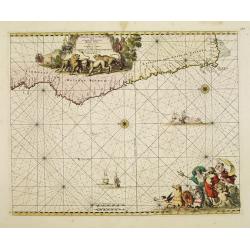
Cimbebas et Caffariae Littora a Catenbela ad Promontorium..
The coast of Angola, South-West Africa and South Africa up to Port Elizabeth. Classic sea chart of Dutch school with excellent baroque embellishment. North oriented to th...
Date: Amsterdam, 1675
Selling price: ????
Please login to see price!
Sold in 2008
Barbariae et Guineae Maritimi. . .
A highly decorative sea chart of the northwest coast of Africa, including from Spain, across the Straits of Gibraltar to Gambia. The various islands groups in the Atlant...
Date: Amsterdam, 1675
Selling price: ????
Please login to see price!
Sold in 2008
Cimbebas et Caffariae Littora a Catenbela ad Promontorium..
The coast of Angola, South-West Africa and South Africa up to Port Elizabeth. Classic sea chart of Dutch school with excellent baroque embellishment. North oriented to th...
Date: Amsterdam, 1675
Selling price: ????
Please login to see price!
Sold in 2010
A chart of the Seacoasts from the landsend of England to Cape Bonna Esperanca.
This rare "slave-trade" sea chart depicts the West coast of Africa from Egypt along to the Cape of Good Hope. In upper right corner scales in English, French, D...
Date: London, 1675
Selling price: ????
Please login to see price!
Sold in 2009
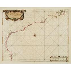
Hispaniae, et Portugalliae, Maritimi Tractus a S. Andero ad Malagam. Pascaert van Spangie en Portugal.
Chart of the Atlantic Ocean and the region of Portugal, Gilbralter and southwestern Spain from Frederick de Wit's Zee Atlas. Coastal cities, bodies of water and islands a...
Date: Amsterdam, 1675
Selling price: ????
Please login to see price!
Sold in 2010

Carte de la Hongarie a l'Autriche. .
A detailed and scarce map showing Hungary and Austria engraved by de François Lapointe (Lépine). Dated 1664.With a dedication to Ferdinand-Ernest Comte d'Abensperg-Trau...
Date: Paris, 1676
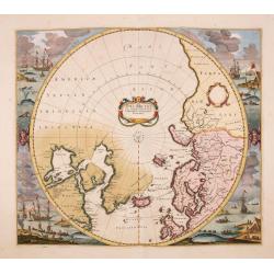
Poli Arctici, et circumiacentium terrarum descriptio novissima. . .
A re-issue of the Hondius' plate, but without the signature. A particularly decorative map of the North Pole. Several Dutch names in Labrador. The toponymy in Canada refl...
Date: Amsterdam, ca.1676
Selling price: ????
Please login to see price!
Sold in 2016
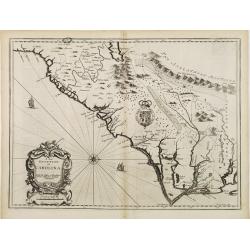
A new description of Carolina.
A wonderful map of Carolina. Incorporated into a 1676 reissue of Speed's 'Prospect Of The Most Famous Parts Of The World'. The map is (in)famous for its depiction of the ...
Date: London, 1676
Selling price: ????
Please login to see price!
Sold in 2021
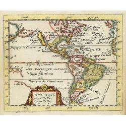
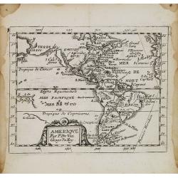
Amerique.
Uncommon miniature map of North and South America, showing California as an island with flat northern coast. Suggestion of D.d'Anien to north of California. Large Terre d...
Date: Paris, 1676
Selling price: ????
Please login to see price!
Sold in 2021
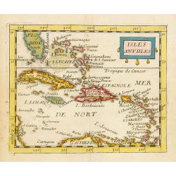
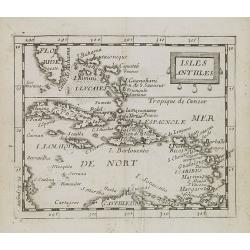
Isles Antilles.
Uncommon miniature map of the Caribbean, including the southern tip of Florida. From Pierre Duval's La Geographie Universeille dated 1676. Following his Cartes de geogr...
Date: Paris, 1676
Selling price: ????
Please login to see price!
Sold in 2014
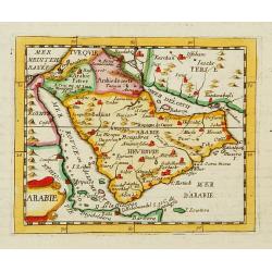
Arabie.
Uncommon miniature map of the Arabian peninsular, from Pierre Duval's La Geographie Universeille dated 1676. Following his Cartes de geographie in 1657, Pierre Duval publ...
Date: Paris 1676
Selling price: ????
Please login to see price!
Sold
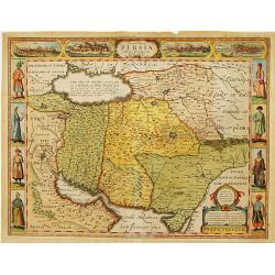
The Kingdom of Persia ..
One of the most decorative maps of the old Kingdom of Persia, including Iran, Iraq, Pakistan, known for its figured borders with people in local dress, among them a Turki...
Date: London 1676
Selling price: ????
Please login to see price!
Sold
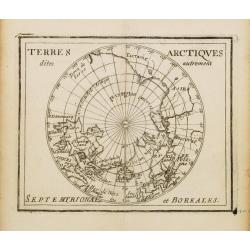
Terres Arctiques.. Septemtrional et Boreales.
Uncommon miniature map of the North Pole, including Iceland, the coast of Russia, Greenland, etc, from Pierre Duval's La Geographie Universeille dated 1676. Following his...
Date: Paris, 1676
Selling price: ????
Please login to see price!
Sold
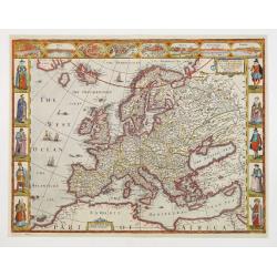
EUROP, and the cheife Cities contayned therin described..
A good impression from an early edition of this famous and decorative cartes-a-figures from the first world atlas produced by an Englishman - John Speed?s Prospect Of The...
Date: London 1676
Selling price: ????
Please login to see price!
Sold
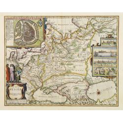
A map of Russia.
One of the most decorative maps of Russia, known for its figured borders with people in local dress, among them a Turkish woman and man. Upper panel of town panoramas of ...
Date: London 1676
Selling price: ????
Please login to see price!
Sold
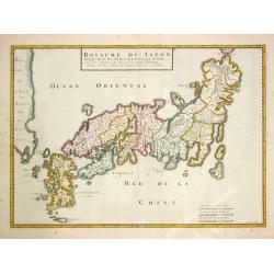
Royaume de Japon.
The second state of Père Philippe's map of Japan.
Date: Paris, N. Sanson,1676
Selling price: ????
Please login to see price!
Sold in 2015
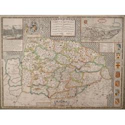
NORFOLK A COUNTIE FLORISHING & POPULOUS DESCRIBED AND DEVIDED WITH THE ARMES OF SUCH NOBLE FAMILIES AS HAVE BORNE THE TITLES THEREOF.
John Speed's fine map of county published in London by Bassett & Chiswell 1676. The map is embellished with an inset town plan of Norwich, the royal arms with support...
Date: London 1676
Selling price: ????
Please login to see price!
Sold in 2013
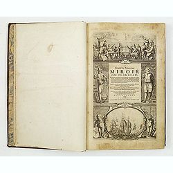
Le Grand & Nouveau Miroir ou Flambeau de la Mer.
Unrecorded french text edition. Engraved title-page, 32 double-page charts, 1 engraved text-chart of St.MALO, numerous woodcuts of astronomical diagrams, compass, geometr...
Date: Amsterdam, 1676
Selling price: ????
Please login to see price!
Sold
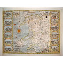
Wales
This is a spectacular and sought after map of Wales by John Speed. Considered to be the most decorative map of the country ever published. The work contains twelve large ...
Date: London, ca. 1676
Selling price: ????
Please login to see price!
Sold
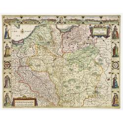
A Newe mape of Poland Done into English by I.Speede.
A wonderful map of Poland. Incorporated into Speed's 'Prospect Of The Most Famous Parts Of The World'. Includes birds-eye views of Cracow, Dantzick, Posna, Crossen, Sando...
Date: London 1676
Selling price: ????
Please login to see price!
Sold
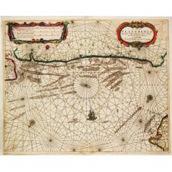
De Custen van Laplant tusschen de Rivier van Kola en de eylande van Swetenoes / het eylant Kilduyn met de rede / De Rivier van Kola in 't groot besteck.
Theunis Jacobsz, Amsterdam-based maritime publisher added Lootsman (pilot) to his name. After his death in 1650, his sons Jacob Theunisz and Casparus continued the firm. ...
Date: Amsterdam, 1676
Selling price: ????
Please login to see price!
Sold
Cust van Hollant Tusschen de Maes ende Texel.
A sea-chart of the coast of Holland with the "Bree Veertien", the large shallow which lays before the coast. Embellished with two cartouches, a ship and two com...
Date: Amsterdam, 1676
Selling price: ????
Please login to see price!
Sold in 2019
De Cust van Zeeland.
Theunis Jacobsz, Amsterdam-based maritime publisher added Lootsman (pilot) to his name. After his death in 1650, his sons Jacob Theunisz and Casparus continued the firm. ...
Date: Amsterdam, 1676
Selling price: ????
Please login to see price!
Sold
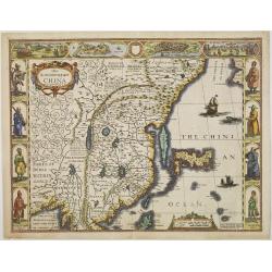
The Kingdome of China.
A most sought-after "carte à figures" map of China. Decorative border vignettes including views of the cities of Quinzay and Macao along the top border with th...
Date: London, 1627-1676
Selling price: ????
Please login to see price!
Sold in 2009
De Cust van Vlaenderen, vande Wielingen to aenden Hoofde.
Theunis Jacobsz, Amsterdam-based maritime publisher added Lootsman (pilot) to his name. After his death in 1650, his sons Jacob Theunisz and Casparus continued the firm. ...
Date: Amsterdam, 1676
Selling price: ????
Please login to see price!
Sold in 2008
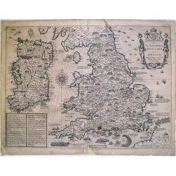
The Invasions of England and Ireland ...
A finely engraved map with an attractive title cartouche that is surmounted by royal arms, a compass rose and rhumb lines. The content of this map features the invasions ...
Date: London, 1676
Selling price: ????
Please login to see price!
Sold in 2009
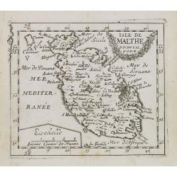
Isle de Malthe.
Uncommon miniature map of Malta from Pierre Duval's La Geographie Universeille dated 1676. Following his Cartes de geographie in 1657, Pierre Duval published this smaller...
Date: Paris, 1676
Selling price: ????
Please login to see price!
Sold in 2008
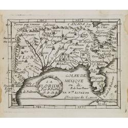
La Floride.
Uncommon miniature map of Florida from Pierre Duval\'s La Geographie Universeille dated 1676. Following his Cartes de geographie in 1657, Pierre Duval published this smal...
Date: Paris, 1676
Selling price: ????
Please login to see price!
Sold in 2008
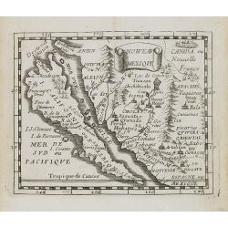
Noweau Mexique.
Uncommon miniature map of New Mexico from Pierre Duval\'s La Geographie Universeille. Following his Cartes de geographie in 1657, Pierre Duval published this smaller size...
Date: Paris, 1676
Selling price: ????
Please login to see price!
Sold in 2008
Isles Antlles.
Uncommon miniature map of the Caribbean islands from Pierre Duval's La Geographie Universeille dated 1676. Following his Cartes de geographie in 1657, Pierre Duval publis...
Date: Paris, 1676
Selling price: ????
Please login to see price!
Sold in 2008
Amérique.
Uncommon miniature map of the Americas from Pierre Duval\'s La Geographie Universeille dated 1676. Following his Cartes de geographie in 1657, Pierre Duval published this...
Date: Paris, 1676
Selling price: ????
Please login to see price!
Sold in 2008
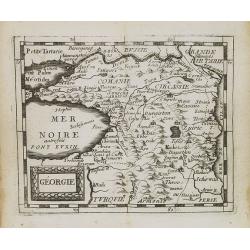
Géorgie.
Uncommon miniature map of Georgia from Pierre Duval's La Geographie Universeille dated 1676. Following his Cartes de geographie in 1657, Pierre Duval published this small...
Date: Paris, 1676
Selling price: ????
Please login to see price!
Sold in 2008
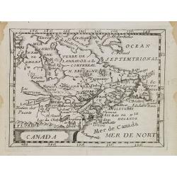
Canada.
Uncommon miniature map of Canada, Great Lakes and the east coast of the United States far south till Chesapeake Bay. Derived from his uncle, Nicolas Sanson\'s map of Le C...
Date: Paris, 1676
Selling price: ????
Please login to see price!
Sold in 2008
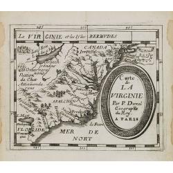
Carte de La Virginie.
Uncommon miniature map of Virginia from Pierre Duval\'s La Geographie Universeille dated 1676. It depicts the now defeated Swedish colony, and the inactive French claim o...
Date: Paris, 1676
Selling price: ????
Please login to see price!
Sold in 2008
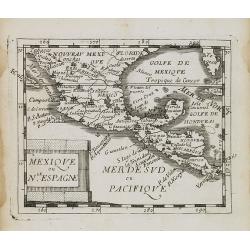
Mexique ou le Nll. Espagne.
Uncommon miniature map of Mexico, central America and the Gulf of Mexico. From Pierre Duval\'s La Geographie Universeille dated 1676. Following his Cartes de geographie i...
Date: Paris, 1676
Selling price: ????
Please login to see price!
Sold in 2008
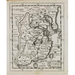
Chine.
Uncommon miniature map of China, Taiwan and Korea as an island, from Pierre Duval's La Geographie Universeille. Following his Cartes de geographie in 1657, Pierre Duval p...
Date: Paris, 1676
Selling price: ????
Please login to see price!
Sold in 2008
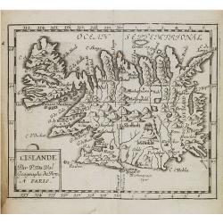
L'Islande.
Uncommon miniature map of Iceland from Pierre Duval's La Geographie Universeille. Following his Cartes de geographie in 1657, Pierre Duval published this smaller size atl...
Date: Paris, 1676
Selling price: ????
Please login to see price!
Sold in 2008
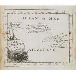
Isles Terceres dites Acores.
Uncommon miniature map of Azores from Pierre Duval's La Geographie Universeille dated 1676. Following his Cartes de geographie in 1657, Pierre Duval published this smalle...
Date: Paris, 1676
Selling price: ????
Please login to see price!
Sold in 2008
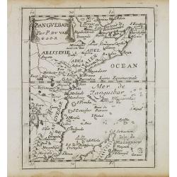
Zanguebar.
Uncommon miniature map of East Africa including Northern tip of Madagascar, from Pierre Duval's La Geographie Universeille. Following his Cartes de geographie in 1657, Pi...
Date: Paris, 1676
Selling price: ????
Please login to see price!
Sold in 2008
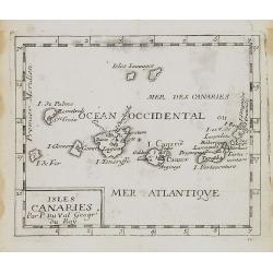
Isles Canaries.
Uncommon miniature map of Canary Islands from Pierre Duval's La Geographie Universeille dated 1676. Following his Cartes de geographie in 1657, Pierre Duval published thi...
Date: Paris, 1676
Selling price: ????
Please login to see price!
Sold in 2008
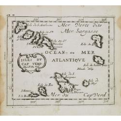
Isles du Cap Verd.
Uncommon miniature map of Cape Verde Islands from Pierre Duval's La Geographie Universeille dated 1676. Following his Cartes de geographie in 1657, Pierre Duval published...
Date: Paris, 1676
Selling price: ????
Please login to see price!
Sold in 2008
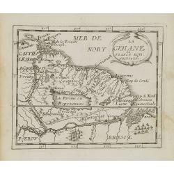
La Guaiane.
Uncommon miniature map of French Guyana in Latin America from Pierre Duval\'s La Geographie Universeille dated 1676. It is bordered to the east by Suriname, to the south ...
Date: Paris, 1676
Selling price: ????
Please login to see price!
Sold in 2008
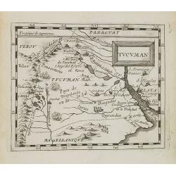
Tucuman.
Uncommon miniature map of part of Argentina, centered on Buenos Aires and Rio La Plata, from Pierre Duval's La Geographie Universeille dated 1676. Following his Cartes de...
Date: Paris, 1676
Selling price: ????
Please login to see price!
Sold in 2008
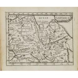
Tartarie.
Uncommon miniature map of Tartary and Tibet, from Pierre Duval's La Geographie Universeille dated 1676. Following his Cartes de geographie in 1657, Pierre Duval published...
Date: Paris, 1676
Selling price: ????
Please login to see price!
Sold in 2009
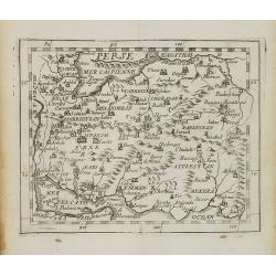
Perse.
Uncommon miniature map of Persia from Pierre Duval's La Geographie Universeille dated 1676. Following his Cartes de Géographie in 1657, Pierre Duval published this small...
Date: Paris, 1676
Selling price: ????
Please login to see price!
Sold in 2009
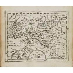
La Turquie en Asie.
Uncommon miniature map of Turkey, Cyprus, Palestine, Iran and Iraq. From Pierre Duval's La Geographie Universeille dated 1676. Following his Cartes de geographie in 1657,...
Date: Paris, 1676
Selling price: ????
Please login to see price!
Sold in 2008
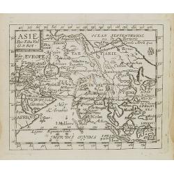
Asie.
Uncommon miniature map of Asia from Pierre Duval's La Geographie Universeille dated 1676. Following his Cartes de geographie in 1657, Pierre Duval published this smaller ...
Date: Paris, 1676
Selling price: ????
Please login to see price!
Sold in 2008
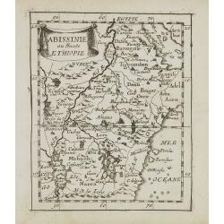
Abissinie ou Haute Ethiopie.
Uncommon miniature map of Ethiopia from Pierre Duval's La Geographie Universeille dated 1676. Following his Cartes de geographie in 1657, Pierre Duval published this smal...
Date: Paris, 1676
Selling price: ????
Please login to see price!
Sold in 2008
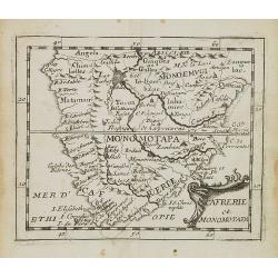
Cafrerie et Monomotapa.
Uncommon miniature map of South Africa from Pierre Duval's "La Geographie Universeille" dated 1676. Following his Cartes de geographie in 1657, Pierre Duval pub...
Date: Paris, 1676
Selling price: ????
Please login to see price!
Sold in 2008