Browse Listings
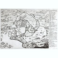
Siege de La Rochelle.
Rare battle plan of the seaport town of LA ROCHELLE illustrating the Siege of La Rochelle between the French Calvinist Huguenots with support of the English and the Catho...
Date: Vienna, 1672
Selling price: ????
Please login to see price!
Sold in 2023
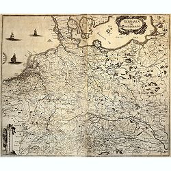
GERMANIA vulgo Teutschlandt.
A rare map of Germania by Gualdo Priorato (1606-1678), who entered military service at a very young age and served in Flanders under the Prince of Orange. During his vari...
Date: Vienna, 1672
Selling price: ????
Please login to see price!
Sold in 2018
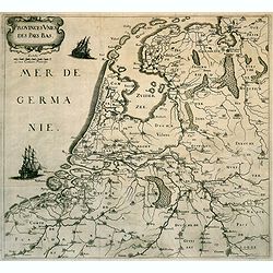
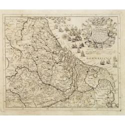
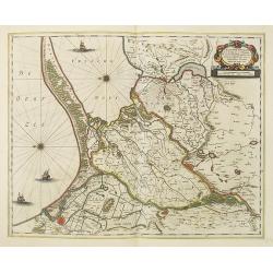
Provinces des Pays-Bas. (The Low Countries)
Rare map of the Low Countries, published by Gualdo Priorato (1606-1678), who entered military service at a very young age and served in Flanders under the Prince of Orang...
Date: Vienna, 1672
Selling price: ????
Please login to see price!
Sold in 2018
![Noweav Mexiqve. [California as an Island]](/uploads/cache/07724-250x250.jpg)
Noweav Mexiqve. [California as an Island]
Uncommon miniature map of California as a island, from Pierre Duval's La Géographie Universelle dated 1676. The map is derived from Audience de Guadalajara , 1657, by hi...
Date: Paris, 1672
Selling price: ????
Please login to see price!
Sold in 2016
![[Acadie-Québec].](/uploads/cache/64901-250x250.jpg)
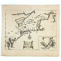
[Acadie-Québec].
A very rare map published in "Description Géographique et Historique des Costes de l'Amérique Septentrionale...". The map carries 92 place names. On it Denys ...
Date: Paris, 1672
Selling price: ????
Please login to see price!
Sold
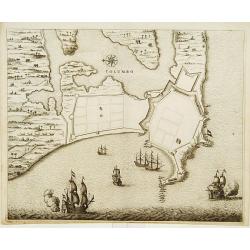
COLOMBO.
Fine plan of Colombo and surroundings, from Naauwkeurige beschryvinge van Malabar en Choromandel...
Date: Amsterdam 1672
Selling price: ????
Please login to see price!
Sold
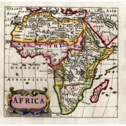
Africa (heightened with gold leaf)
From a copy of "Introductionis in Universam Geographicam". Published by Bertius in Amsterdam and printed on the Elzevier press. Beautiful map in period correct ...
Date: Amsterdam, ca. 1672
Selling price: ????
Please login to see price!
Sold
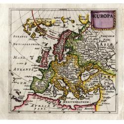
Europa (heightened with gold leaf)
From a copy of "Introductionis in Universam Geographicam". Published by Bertius in Amsterdam and printed on the Elzevier press. Beautiful map in period correct ...
Date: Amsterdam, ca. 1672
Selling price: ????
Please login to see price!
Sold
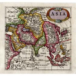
Asia (heightened with gold leaf)
From a copy of "Introductionis in Universam Geographicam". Published by Bertius in Amsterdam and printed on the Elzevier press. Beautiful map in period correct ...
Date: Amsterdam, ca. 1672
Selling price: ????
Please login to see price!
Sold
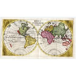
Orbis Terrarum Typus (heightened with gold leaf)
From a copy of "Introductionis in Universam Geographicam". Published by Bertius in Amsterdam and printed on the Elzevier press. This double-hemisphere world ma...
Date: Amsterdam, ca. 1672
Selling price: ????
Please login to see price!
Sold
Belgii seu XVII Provincia inferioris Germanie ex optimus quibusq. . .
Very rare map of the present-day Netherlands, Belgium and Luxembourg.François Collignon, originating from Nancy, is reckoned among the great engravers of his day. He lea...
Date: Rome, dated 1672
Selling price: ????
Please login to see price!
Sold in 2008

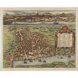
Goa.
A combined panoramic and bird's eye-town-plan of Goa, the main Portuguese trading post in India. From Philippus Baldaeus "Naauwkeurige Beschryvinge Van Malabar en Ch...
Date: Amsterdam, 1672
Selling price: ????
Please login to see price!
Sold in 2008
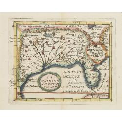
La Floride.
Uncommon miniature map of Florida and Louisiana from Pierre Duval's La Geographie Universeille dated 1676.
Date: Paris, 1672
Selling price: ????
Please login to see price!
Sold in 2013
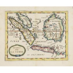
Isles de la Sonde.
Uncommon miniature map of the Indonesian islands (Java, Sumatra and Borneo) from Pierre Duval's La Geographie Universeille dated 1676. With "Sincapura" and &quo...
Date: Paris, 1672
Selling price: ????
Please login to see price!
Sold in 2022
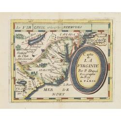
Carte de La Virginie.
Uncommon miniature map of Virginia, from Pierre Duval's La Geographie Universeille . It depicts the now defeated Swedish colony, and the inactive French claim of FLORIDE ...
Date: Paris, 1672
Selling price: ????
Please login to see price!
Sold in 2012
Goa.
A combined panoramic and bird's eye-town-plan of Goa, the main Portuguese trading post in India. From Philippus Baldaeus "Naauwkeurige Beschryvinge Van Malabar en Ch...
Date: Amsterdam, 1672
Selling price: ????
Please login to see price!
Sold in 2011
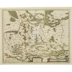
Ducatus Oswieczensis et Zatoriensis.
Showing part of Southern Poland above the Carpathian Mountains.The atlas Major was printed only in small numbers, the Spanish text edition is extremely rare. The Spanish ...
Date: Amsterdam, 1659-1672
Selling price: ????
Please login to see price!
Sold in 2015
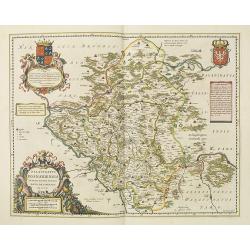
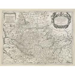
Palatinatus posnaniensis in Maiori Polonia Primarii nova delineatio.
Rare map published by Joan Blaeu in his Major Atlas. With decorative cartouches, The cartouche upper left with a dedication to Georg Freudenhammer, who was a doctor and m...
Date: Amsterdam, 1659-1672
Selling price: ????
Please login to see price!
Sold in 2015
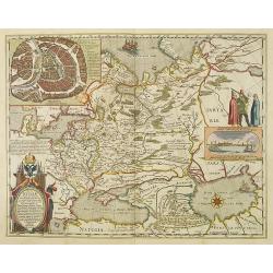
Tabula Russiae ex autographo, quod delineandum curavit Foedor filius Tzaris Boris desums... - Domino regionum Iueriae Kartalinie et Groefiniae Tzari etc: dedicata ab Heselo Gerardo M.DC.XIIII
re-issue, by Willem Blaeu, of Hessel Gerritsz' rare and influential map of Russia. Dutch text on verso, extending west to east from Emden to Aspachan and north to south f...
Date: Amsterdam, 1659-1672
Selling price: ????
Please login to see price!
Sold in 2010
Tractuum Borussiae, circa Gedanum et Elbingam..
A decorative map from Blaeu's Atlas Major, including the region where the Nogat and Wista Rivers flow into the Gulf of Gdansk. The map includes incredible detail of the r...
Date: Amsterdam, 1659-1672
Selling price: ????
Please login to see price!
Sold in 2020
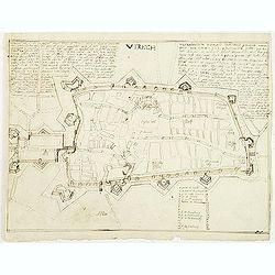
Utrech (Utrecht)
Manuscript fortification town-plan of Utrecht, as it was at about 1672. With a numbered key (1-34) pointing to the important buildings, streets and canals in town. Only 1...
Date: France, ca. 1672
Selling price: ????
Please login to see price!
Sold in 2011
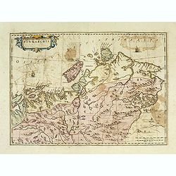
Finmarchia.
The map of Finnmark and northernmost Lapland based on the Great Scandinavian Atlas of Anders Bure (1626). This map was published in a Spanish text edition of the multi-vo...
Date: Amsterdam, 1672
Selling price: ????
Please login to see price!
Sold in 2014

Nazareth.
Decorative view of Nazareth, below a decorative cartouche with numbered key and surrounded by 2 cherubins. Taken from a very rare travel book by Anthonius Gonsales, "...
Date: Antwerpen, Michiel Cnobbaert, 1673
![Rama. [Ramah]](/uploads/cache/30789-250x250.jpg)
Rama. [Ramah]
Town plan of Ramah, about 5 miles (8 km) from Jerusalem and near to Gibeah. Below a decorative cartouche with numbered key and surrounded by 2 cherubins.Taken from a very...
Date: Antwerpen, Michiel Cnobbaert, 1673
![Via Bethleem. [The route from Jerusalem to Bethlehem ]](/uploads/cache/30800-250x250.jpg)
Via Bethleem. [The route from Jerusalem to Bethlehem ]
The route from Jerusalem to Bethlehem. Below a lettered key. Taken from a very rare travel book by Anthonius Gonsales, "Hierusalemsche Reyse". The book describe...
Date: Antwerpen, Michiel Cnobbaert, 1673
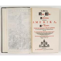
Die Unbekante Neue Welt oder Beschreibung des Welt-teils America
German text edition of the greatest illustrated book on America of the seventeenth century. Included are a large folding map of the western hemisphere as well as maps of ...
Date: Amsterdam 1673
Selling price: ????
Please login to see price!
Sold
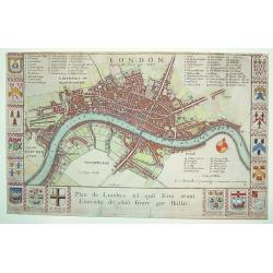
LONDON BEFORE THE FIRE IN 1666
A rare, sought after 17th century plan of London prior to the Great Fire. The work is beautifully engraved and elaborately decorated with the arms of major London merchan...
Date: London, ca. 1673
Selling price: ????
Please login to see price!
Sold
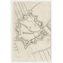
Woerden.
Plan of the Dutch town Woerden in the now-a-days province "Zuid Holland". From Priorato's book "Schauplatz dess Niderlands", printed and edited in Vi...
Date: Vienna 1673
Selling price: ????
Please login to see price!
Sold
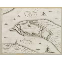
Schenkenschans.
Plan of the Dutch bastion/town Schenkenschans in the nowadays province Gelders. From Prirato's book "Schauplatz dess Niderlands", printed and edited in Vienna ...
Date: Vienna 1673
Selling price: ????
Please login to see price!
Sold in 2008
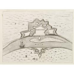
Ravestein.
Plan of the Dutch town Ravestein in the nowadays province Brabant. From Priorato's book "Schauplatz dess Niderlands" printed and edited in Vienna 1673.
Date: Vienna 1673
Selling price: ????
Please login to see price!
Sold
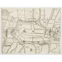
Alkmaar.
Plan of the Dutch town Alkmaar in the now-a-days province Nord Holland. From Priorato's book "Schauplatz dess Niderlands", printed and edited in Vienna 1673.
Date: Vienna 1673
Selling price: ????
Please login to see price!
Sold

Den Brielle.
Plan of the Dutch town Brielle in the now-a-days province of South Holland. From Priorato's book "Schauplatz dess Niderlands", printed and edited in Vienna 167...
Date: Vienna 1673
Selling price: ????
Please login to see price!
Sold
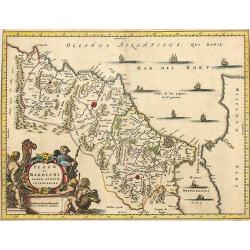
Fezzae et Marochi.
Decorative map of Morocco based on Blaeu's map of the same title. It is oriented with north on the right and includes the Strait of Gibraltar. The sea is filled with seve...
Date: Amsterdam, 1673
Selling price: ????
Please login to see price!
Sold in 2015
Barbaria, Biledulgerid, Libye et pars Nigritarum terra.
A map from Olfert Dapper's Africa. It depicts Algeria, Tunesia and western Libya. Embellished with a very decorative cartouche.
Date: Amsterdam, 1673
Selling price: ????
Please login to see price!
Sold in 2020
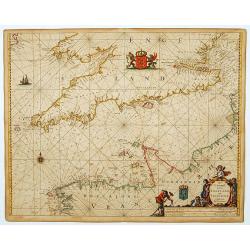
Het Canaal tusschen Engeland en Vranciick.
An eye-catching of the Channel.Pieter Goos (ca. 1616-1675) was one of the most important cartographer, engraver, publisher and print seller of Amsterdam. His widow conti...
Date: Amsterdam, 1673
Selling price: ????
Please login to see price!
Sold in 2015
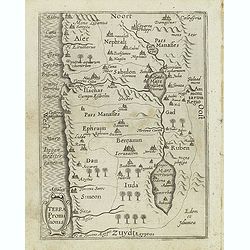
Terra promihonis.
Map of the Holy Land, included in a very rare travel book by Anthonius Gonsales, "Hierusalemsche Reyse". The book describes his pilgrimage from Antwerp to Jerus...
Date: Antwerpen, Michiel Cnobbaert, 1673
Selling price: ????
Please login to see price!
Sold in 2011
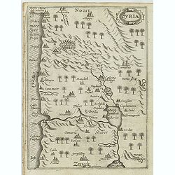
Syria.
Decorative and rare map of Syria, showing the cities of Nazareth, Jerusalem, Masaloth. Taken from a very rare travel book by Anthonius Gonsales, "Hierusalemsche Reys...
Date: Antwerpen, Michiel Cnobbaert, 1673
Selling price: ????
Please login to see price!
Sold in 2011
![Vallis Therebinthi. [valley of Terebinthus]](/uploads/cache/30791-250x250.jpg)
Vallis Therebinthi. [valley of Terebinthus]
Valley of Terebinthus, below a decorative cartouche with lettered key and surrounded by 2 cherubins.From a very rare travel book by Anthonius Gonsales, "Hierusalemsc...
Date: Antwerpen, Michiel Cnobbaert, 1673
Selling price: ????
Please login to see price!
Sold in 2011
![Domue. Boni. Latronis. [with Jacob's Well ]](/uploads/cache/30792-250x250.jpg)
Domue. Boni. Latronis. [with Jacob's Well ]
View with Jacob's Well. Below a decorative cartouche with lettered key and surrounded by 2 cherubins.Taken from a very rare travel book by Anthonius Gonsales, "Hieru...
Date: Antwerpen, Michiel Cnobbaert, 1673
Selling price: ????
Please login to see price!
Sold in 2011

No tittle.
Decorative view of a cave where Adam's head was found. Below is a decorative cartouche with numbered key and surrounded by 2 cherubins.Taken from a very rare travel book ...
Date: Antwerpen, Michiel Cnobbaert, 1673
Selling price: ????
Please login to see price!
Sold in 2023
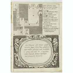
De plante ost Vloer vande Kercke daer Chritus. . .
Decorative print showing a plan of the Church of Nativity, below a decorative cartouche with "De plante ost Vloer vande Kercke daer chritus...", surrounded by 2...
Date: Antwerpen, Michiel Cnobbaert, 1673
Selling price: ????
Please login to see price!
Sold in 2018
![Mons Carnelus. [Mount Carmel]](/uploads/cache/31006-250x250.jpg)
Mons Carnelus. [Mount Carmel]
One of the mountains of spiritual realm mentioned in the Bible. The Mount Carmel Range and the Mediterranean Sea near modern Haifa. The modern town of Haifa sits partiall...
Date: Antwerpen, Michiel Cnobbaert, 1673
Selling price: ????
Please login to see price!
Sold in 2011
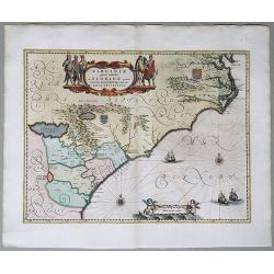
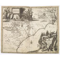
Virginiae partis australis, et Floridae partis orientalis. . . Nova Descriptio.
A map of the East Coast of North America, showing the cost from Chesapeake Bay to the northern part of Florida. The full title in a cartouche at the top reads: Virginiae ...
Date: Amsterdam, 1673
Selling price: ????
Please login to see price!
Sold in 2020
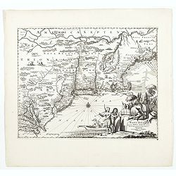
Novi Belgii, quod nunc Novi Jorck vocatur, Novaeque Angliae & Partis Virginiae Accuratissima et Novissima Delineatio.
A beautifully engraved map of the Northeast, extending from the St. Laurence and New England to the Chesapeake and centered on Long Island, which is still shown as an isl...
Date: Amsterdam, 1673
Selling price: ????
Please login to see price!
Sold in 2022
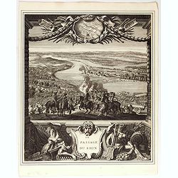
Le passage du Rhin.
Splendid engraving by Juan Dolivar van der Meulen showing the army of Louis XIV crossing the river Rhine and arriving into the Netherlands at Lobith. From the series &quo...
Date: Paris, 1673
Selling price: ????
Please login to see price!
Sold in 2020
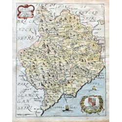
A Mapp of ye County of Mounmouthshire with Hundreds.
A very attractive map of Monmouthshire in Wales, which appeared in Richard Blome's 'Britannia'. Detailed with place names, rivers, and hills. Decorated with the title car...
Date: London, 1673
Selling price: ????
Please login to see price!
Sold in 2020
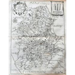
A Mapp of Staffordshire with its hundreds.
An early and attractive map of Staffordshire, published in Richard Blome's 'Britannia'. Very detailed with many place names, rivers, and hills. Decorated with the title c...
Date: London, 1673
Selling price: ????
Please login to see price!
Sold in 2020
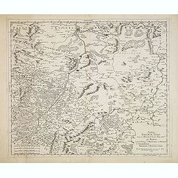
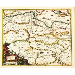
Nemetes Evesché de Spire partie de l'Eslectorat et Palatinat du Rhein. . .
Detailed and rare map of Speyer, including the towns of Mannheim, Heidelberg, Heilbronn, Bad Bergzabern and Sindelfingen by Nicolas Sanson d' Abbeville in Paris. Dated 16...
Date: Paris, 1673
Selling price: ????
Please login to see price!
Sold in 2021
London.
An attractive early map of pre-fire London , decorated with the coats of arms of the City of London, fifteen of the great Livery and Merchant Companies, and those of Sir ...
Date: London, 1673
Selling price: ????
Please login to see price!
Sold in 2013
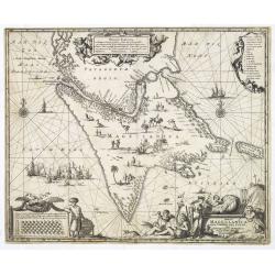
Tabula Magellanica qua tierrae del Fuego. . .
One of the most decorative maps of the extremity of South America, with Patagonia, the Straight of Magellan, Terra del Fuego and the discoveries made by LeMaire and Schou...
Date: Amsterdam, 1673
Selling price: ????
Please login to see price!
Sold in 2013
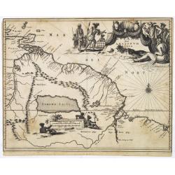
Guiana sive Amazonum Regio.
Map of Guiana and Amazon extending westwards to Trinidad and Margarita Island, dominated by a huge inland sea north of the Amazon.Embellished with decorative title and sc...
Date: Amsterdam, 1673
Selling price: ????
Please login to see price!
Sold in 2025
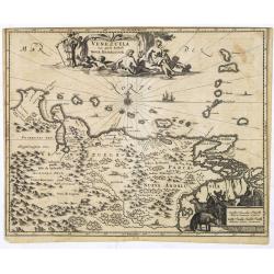
Venezuela cum parte Australi Novae Andalusiae.
Most decorative map with two large cartouches and compass-rose, large group of islands at the mouth of the Orinoco, other islands off Venezuela coast: Margarita, Aruba, C...
Date: Amsterdam, 1673
Selling price: ????
Please login to see price!
Sold in 2025
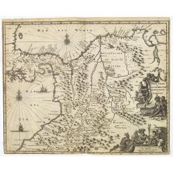
Terra Firma et Novum Regnum Granatense et Popayan.
Detailed map of Panama and northwestern South America derived from the Blaeu/Jansson map of the regionFeaturing ships at sea, two compass roses, and two cartouches depict...
Date: Amsterdam, 1673
Selling price: ????
Please login to see price!
Sold in 2025
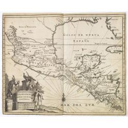
Nova Hispania Nova Galicia Guatimala
A fine map based on the cartography of Hessel Gerritsz. The map includes Mexico through Costa Rica with nice detail.Large pictorial cartouche depicting Native Americans l...
Date: Amsterdam, 1673
Selling price: ????
Please login to see price!
Sold in 2013
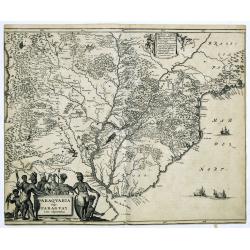
Paraquaria vulgo Paraguay cum adjacentibus.
Detailed map extending from Rio de Janeiro to the Rio de la Plata basin in what is today Argentina.The title cartouche of this highly decorative map features Indians and ...
Date: Amsterdam, 1673
Selling price: ????
Please login to see price!
Sold in 2022
Virginiae partis australis, et Floridae partis orientalis. . .
A beautifully engraved map, derived from the highly influential maps by Mercator and later Blaeu, covering the area from the lower Chesapeake Bay to northern Florida. The...
Date: Amsterdam, 1673
Selling price: ????
Please login to see price!
Sold in 2015
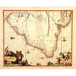
Brasila.
Map of Brazil extending from C. Nasou and Parime Lago to the Mouth of the Rio de la Plata. Oriented with West on top.The cartography of the region is quite primitive. The...
Date: Amsterdam, 1673
Selling price: ????
Please login to see price!
Sold in 2014
![[Illustration from Hierusalemsche Reyse.] Fons. S. Philippi, et Dessertum. S. IOANNIS](/uploads/cache/30787-250x250.jpg)
[Illustration from Hierusalemsche Reyse.] Fons. S. Philippi, et Dessertum. S. IOANNIS
Taken from a very rare travel book by Anthonius Gonsales, "Hierusalemsche Reyse". The book describes his pilgrimage from Antwerp to Jerusalem and back. Giving a...
Date: Antwerpen, Michiel Cnobbaert, 1673
Selling price: ????
Please login to see price!
Sold in 2014
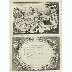
S. Jeremias.
Taken from a very rare travel book by Anthonius Gonsales, "Hierusalemsche Reyse". The book describes his pilgrimage from Antwerp to Jerusalem and back. Giving a...
Date: Antwerpen, Michiel Cnobbaert, 1673
Selling price: ????
Please login to see price!
Sold in 2019
![[Illustration from Hierusalemsche Reyse.] Planta sancticce naculi.](/uploads/cache/30793-250x250.jpg)
[Illustration from Hierusalemsche Reyse.] Planta sancticce naculi.
Taken from a very rare travel book by Anthonius Gonsales, "Hierusalemsche Reyse". The book describes his pilgrimage from Antwerp to Jerusalem and back. Giving a...
Date: Antwerpen, Michiel Cnobbaert, 1673
Selling price: ????
Please login to see price!
Sold in 2020
![[Illustration from Hierusalemsche Reyse.] No tittle.](/uploads/cache/30794-250x250.jpg)
[Illustration from Hierusalemsche Reyse.] No tittle.
Taken from a very rare travel book by Anthonius Gonsales, "Hierusalemsche Reyse". The book describes his pilgrimage from Antwerp to Jerusalem and back. Giving a...
Date: Antwerpen, Michiel Cnobbaert, 1673
Selling price: ????
Please login to see price!
Sold in 2016
![[Illustration from Hierusalemsche Reyse.] Monst Olivettii](/uploads/cache/30795-250x250.jpg)
[Illustration from Hierusalemsche Reyse.] Monst Olivettii
Taken from a very rare travel book by Anthonius Gonsales, "Hierusalemsche Reyse". The book describes his pilgrimage from Antwerp to Jerusalem and back. Giving a...
Date: Antwerpen, Michiel Cnobbaert, 1673
Selling price: ????
Please login to see price!
Sold in 2014
![[Illustration from Hierusalemsche Reyse.] S. Sepulchrum. Christi.](/uploads/cache/30798-250x250.jpg)
[Illustration from Hierusalemsche Reyse.] S. Sepulchrum. Christi.
Taken from a very rare travel book by Anthonius Gonsales, "Hierusalemsche Reyse". The book describes his pilgrimage from Antwerp to Jerusalem and back. Giving a...
Date: Antwerpen, Michiel Cnobbaert, 1673
Selling price: ????
Please login to see price!
Sold in 2014
![[Illustration from Hierusalemsche Reyse.] No tittle](/uploads/cache/30802-250x250.jpg)
[Illustration from Hierusalemsche Reyse.] No tittle
Taken from a very rare travel book by Anthonius Gonsales, "Hierusalemsche Reyse". The book describes his pilgrimage from Antwerp to Jerusalem and back. Giving a...
Date: Antwerpen, Michiel Cnobbaert, 1673
Selling price: ????
Please login to see price!
Sold in 2015

MICHAEL WISNOWETZKI D.G. REX POLONIAE.
Engraving of Michal Korybut Wisniowiecki, King of Poland. Half length with curled hair, moustache, tie, doublet, and mantle edged in ermine, holding a sceptre.Michael I (...
Date: 1669-1673
Selling price: ????
Please login to see price!
Sold in 2018
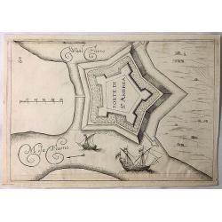
Forte di St. Andrea. (Sint Andre)
A simple copper engraving of the Sint Andre Fort build on the island of Bommel in Gelderland. The illustration is from a Italian edition of the book "Teatro del Belg...
Date: Frankfurt, 1673
Selling price: ????
Please login to see price!
Sold in 2018
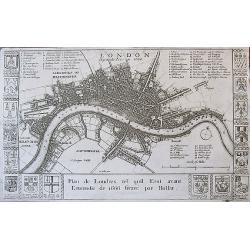
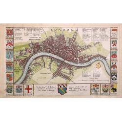
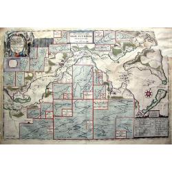
London before the Fire in 1666 / Plan de Londres tel quil Etoi avant L'incendie de 1666 Gravé par Hollar.
A rare 17th century plan of London. Richly decorated with the arms of some 16 London merchant houses. Three legend keys identify 69 points of interest on the map. The Tha...
Date: London, ca. 1673
Selling price: ????
Please login to see price!
Sold in 2017
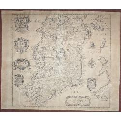
A Mapp of the Kingdome of Ireland.
From 'Britannia', first published in 1673. The map is based on John Speed's map. The map has five Coats of Arms. In this much rarer edition Boyle's Coat of Arms at the to...
Date: London, 1673
Selling price: ????
Please login to see price!
Sold in 2018
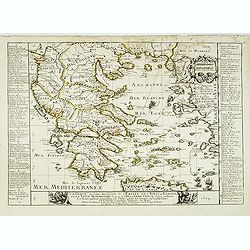
La Grece, ou partie Meridionale de l'Empire des Turcs en Europe, avec le Table Alphabetique des lieux de l'ancienne Grece célèbres en l'Histoire, les noms qu'ils ont aujourd'hui et le chiffre qui les fait trouver . . .
Uncommon map of Greece, widen to Aegean sea with title at bottom. Showing various trade routes from the Dardanelles, Gallipoli and Smyrna through the southern islands and...
Date: Paris, 1674
Selling price: ????
Please login to see price!
Sold
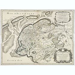
La seigneurie d'ouest-Frise ou Frise Occidentale
Fine map of the Friesland with a decorative title and scale cartouche.Alexis-Hubert Jaillot (1632-1712), was a French cartographer. He joined the Sanson heirs and redrew ...
Date: Paris, 1674
Selling price: ????
Please login to see price!
Sold in 2013
Costes et Rivieres de Virginie, de Mariland et de Nouvelle Angletere. . .
A scarce map that includes the Chesapeake to New England, St. Johns, and Port Royal, showing a single Great Lake "Lake of Herekoys ou Lac des Iroquois." With an...
Date: Paris, Louis Billaine, 1674
Selling price: ????
Please login to see price!
Sold in 2016
Concilia Oeucumenica Nationalia Provincialia ..
A fine map of Europe, depicting a geographic representations of Church history.This edition has the original address of the publisher Apud Petrum Mariette Via Jacoba sub ...
Date: Paris, after 1674
Selling price: ????
Please login to see price!
Sold
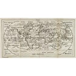
Terraquei Orbis Typ.us In R.P.Dan Bartoli S.J. Geographiam Politico-Moralem. . .
Charming world map included in Daniello Bartoli rare work Geographia. Nikolaus Hautt was a "cartographer, engraver and printer of Constance" his maps appeared D...
Date: Constance, 1674
Selling price: ????
Please login to see price!
Sold in 2008
Le Comte d'Artois suivant qui est presentement divise en Francois et Espagnol . . .
Attractive and very detailed copper engraving with decorative (uncolored) title cartouche and scale. Includes the cities of Abbeville, Arras, Valenciennes and Boulogne in...
Date: Paris, 1674
Selling price: ????
Please login to see price!
Sold
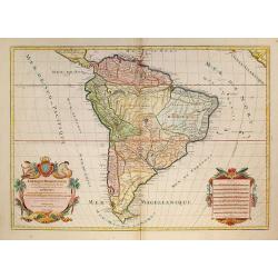
Amérique Méridionale divisée en ses principales Parties.
A very impressive large-scale map. The large decorative title cartouche is balanced by an equally large cartouche around the scale bars, surrounded by Indian figures and ...
Date: Paris, 1674
Selling price: ????
Please login to see price!
Sold in 2009
Accuratissima Sliae Fluminis Descriptio.
Rare map of Schlei Inlet of southern Jutland, Denmark. Highly detailed map, gives depth, tidal and channel information never before seen on a published map of the area. ...
Date: Amsterdam, 1674
Selling price: ????
Please login to see price!
Sold in 2011
Landrecy, Henault .
Striking and highly detailed, fine unusual 1674 Sébastien Pontault de Beaulieu's panoramic view of Landrecies, France, with its buildings, churches, town walls and surr...
Date: Paris, 1674
Selling price: ????
Please login to see price!
Sold in 2020
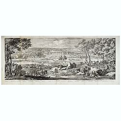
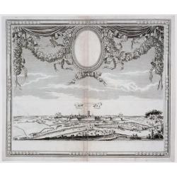
Veüe du Chasteau de Fontainebleau, du costé du Jardin.
Two joined sheets with a landscape with a deer hunting scene in the foreground, beyond cavalry troops, and the gardens and palace of Fontainebleau in the distance.Engrave...
Date: Paris, 1674
Selling price: ????
Please login to see price!
Sold in 2021
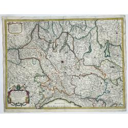
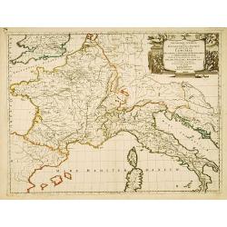
[Lot of 10 maps and prints of ITALY, the Milan States and Italy.
A detailed map of the duchy of Milan and its surrounding states. Alexis-Hubert Jaillot (1632-1712), French cartographer who joined the Sanson heirs. He redrew Nicolas San...
Date: Paris, 1674
Selling price: ????
Please login to see price!
Sold in 2022
![[Engraved Gores for a pair of 20 cm diameter Globes.]](/uploads/cache/46379-250x250.jpg)
[Engraved Gores for a pair of 20 cm diameter Globes.]
Rare engraved globe gores for a pair of 20 cm (8 inch) diameter globes published in Nuremberg, and engraved by J.C. Weigel. Two sets of 12 globe gores on 4 sheets, togeth...
Date: Nuremberg, ca 1675
Selling price: ????
Please login to see price!
Sold in 2020