Please login to see price!.
Subscribe to be notified if similar examples become available.
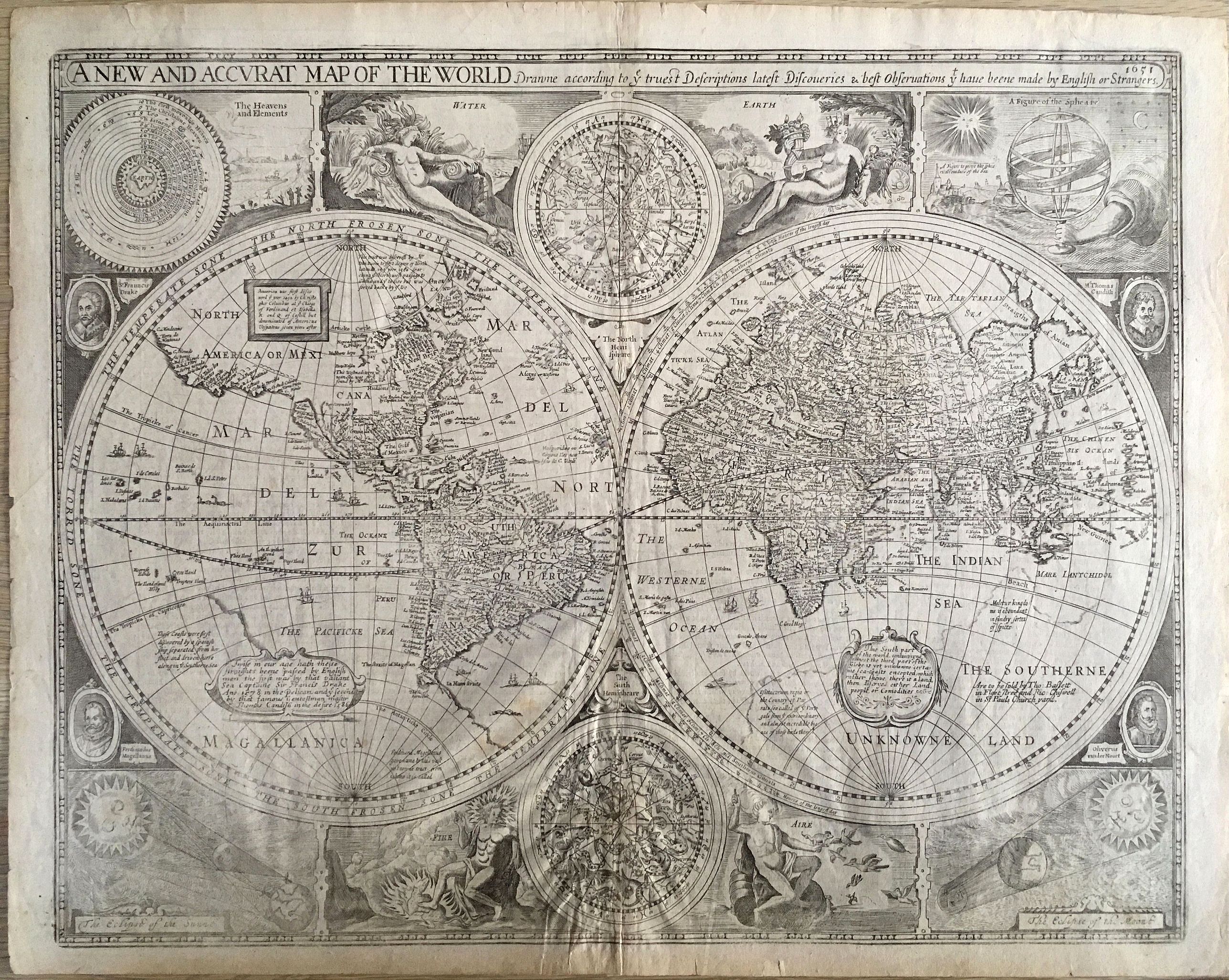
A New and Accurat Map of the World Drawne According to ye Truest Descriptions Latest Discoveries & Best Observations yt Have Beene Made by English or Strangers |
||||||||||||||||||||
|
||||||||||||||||||||
|
|
||||||||||||||||||||
|
Selling price: $...
Please login to see price! Sold in 2018 Missed this item! Be the first to get notified about our newly added listings. Add your name to our mailing list. Feel free to contact us if you have a question about this item. |
Virtual Collection - Save and collect this or any of your favorite items in one place.
If you want to save the items permanently, please sign in or create account first. |
|||||||||||||||||||
Description
This desirable and beautiful double-hemispheric world map carries the imprint of Bassett & Chiswell. The map is dated 1651 but it was known to be published in 1676 with this imprint.
This map is based on William Grent's rare, separately issued map of 1625 (Shirley #313). It is considered one of the earliest published world maps to be printed in English, and is the first atlas map to show the cartographic curiosity of California as an island, which persisted for nearly 100 years. It was also one of the first to show the settlement of New Plymouth.
The coastline in North America is blank east of California and swings wildly to the west in the northern regions of Canada and Alaska. The Straits of Magellan are inaccurately shown and Tierra de Fuego is left open to the west. The "Southerne Unknowne Land" shows the large conjectured continent covering much of the southern hemisphere. The map is beautifully engraved and highly detailed throughout.
The engraver is unknown, but Shirley acknowledges it was most likely Abraham Goos. This highly decorative production is surrounded by two celestial hemispheres, figural allegorical representations of Water, Earth, Air and Fire, plus portraits of Ferdinand Magellan, Oliver vander Noort, Thomas Cavendish and Sir Francis Drake.
The corners are filled with an astronomical table, an armillary sphere, and eclipses of the sun and moon. With several lengthy notes including comments on the South Pole and the Straits of Magellan, Sir Francis Drake and others. Related English text on verso is "The generall Description of the World."
Shirley says this map was not as widely disseminated as those from contemporary Dutch cartographers, and was uncommon outside the UK. Consequently its "rarity value" continues to increase.
Reference: Shirley, World #317; Shirley (BL Atlases) T.SPE-2f.
FAQ - Guarantee - Shipping
Buying in the BuyNow Gallery
This item is available for immediate purchase when a "Add to Cart" or "Inquire Now" button is shown.
Items are sold in the EU margin scheme
Payments are accepted in Euros or US Dollars.
Authenticity Guarantee
 We provide professional descriptions, condition report (based on 45 years experience in the map business)
Paulus Swaen warrants the authenticity of our items and a certificate of authenticity is provided for each acquired lot.
Condition and Coloring
We indicate the condition of each item and use our unnique HiBCoR grading system in which four key items determine a map's value: Historical Importance, Beauty, Condition/Coloring and Rarity.
Color Key
We offer many maps in their original black and white condition. We do not systematically color-up maps to make them more sellable to the general public or buyer.
Copper engraved or wood block maps are always hand colored. Maps were initially colored for aesthetic reasons and to improve readability. Nowadays, it is becoming a challenge to find maps in their original colors and are therefor more valuable.
We use the following color keys in our catalog:
Original colors; mean that the colors have been applied around the time the map was issued.
Original o/l colors; means the map has only the borders colored at the time of publication.
Colored; If the colors are applied recently or at the end of the 20th century.
Read more about coloring of maps [+]
Shipping fee
A flat shipping fee of $ 30 is added to each shipment by DHL within Europe and North America. This covers : International Priority shipping, Packing and Insurance (up to the invoice amount).
Shipments to Asia are $ 40 and rest of the world $50
We charge only one shipping fee when you have been successful on multiple items or when you want to combine gallery and auction purchases.
Read more about invoicing and shipping
FAQ
Please have a look for more information about buying in the BuyNow gallery
Many answers are likely to find in the general help section.
Virtual Collection
![]()
With Virtual Collection you can collect all your favorite items in one place. It is free, and anyone can create his or her Virtual map collection.
Unless you are logged in, the item is only saved for this session. You have to be registed and logged-in if you want to save this item permanently to your Virtual Collection.
Read More[+]
Register here, it is free and you do not need a credit card.
Add this item to
Virtual Collection
or click the following link to see my Virtual Collection.
| Digital Image Download | |
|
Paulus Swaen maintains an archive of most of our high-resolution rare maps, prints, posters and medieval manuscript scans. We make them freely available for download and study. Read more about free image download |
Click the image for a free small image download. |
In accordance with the EU Consumer Rights Directive and habitually reside in the European Union you have the right to cancel the contract for the purchase of a lot, without giving any reason.
The cancellation period will expire 14 calendar days from the day after the date on which you or a third party (other than the carrier and indicated by you) acquires, physical possession of the lot. To exercise the right to cancel you must inform Paulus Swaen Inc, of your decision to cancel this contract by a clear statement (e.g. a letter sent by post, or e-mail (amsterdam@swaen.com).
To meet the cancellation deadline, it is sufficient for you to send your communication concerning your exercise of the right to cancel before the cancellation period has expired.
