Browse Listings
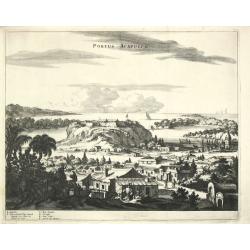
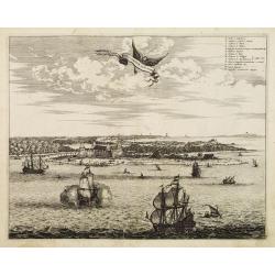
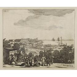
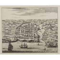
Portus Acapulco.
Arnoldus Montanus, writer of ' De Nieuwe en Onbekende Weereld: of Beschryving van America?, published by Jacob van Meurs.A beautiful, finely etched view of Acapulco.
Date: Amsterdam, 1671
Selling price: ????
Please login to see price!
Sold in 2009
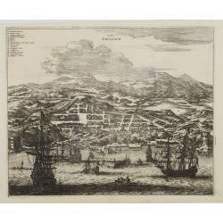
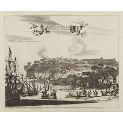
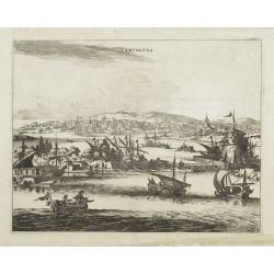
Olinda de Phernambuco.
View of the town of Olinda, north of present-day Recife in Pernambuco with extensive shipping in the foreground.This plate is taken from Ogilby's An Accurate Description ...
Date: London, 1671
Selling price: ????
Please login to see price!
Sold in 2009
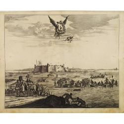
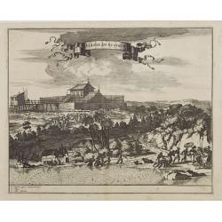
Obsidio et Expugnatio Portus Calvi.
Copper engraving of the Dutch fort at Porto Calvo (Alagoas). The foreground is filled with people, carts, and farmers. Title in banner style cartouche.This print is taken...
Date: London 1671
Selling price: ????
Please login to see price!
Sold
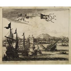
St. Francisco de Campeche.
Large view of St. Francisco de Campeche in the Yucatan with numerous warships fighting in the foreground and firing on the fort. Title ribbon in the sky.This print is tak...
Date: London, 1671
Selling price: ????
Please login to see price!
Sold in 2009
Fluvius Grandis.
A finely engraved view of a heavily armed fort along the Amazon delta. In the foreground soldiers and natives can be seen unloading goods from small boats that have come ...
Date: London 1671
Selling price: ????
Please login to see price!
Sold
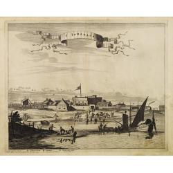
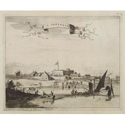
I. Tamaraca.
A superb view of the Dutch Forte Oranje on the Brazilian island of Itamaracá, with small-craft shipping and local products being hauled along the waterfront. A small let...
Date: London, 1671
Selling price: ????
Please login to see price!
Sold in 2008

Christofel Colonus. / Americus Vesputius / Ferdinand Magellanus Francisco Pisarro.
Arnoldus Montanus, writer of ' De Nieuwe en Onbekende Weereld: of Beschryving van America?, published by Jacob van Meurs. A set of 4 portraits of discoverers of America.F...
Date: Amsterdam, 1671
Selling price: ????
Please login to see price!
Sold
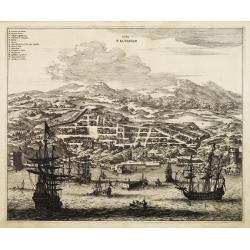
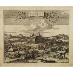
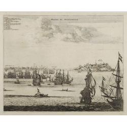
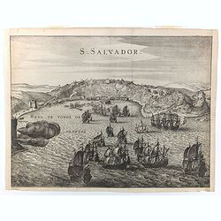
Urbs Salvador.
Fine copper engraving of the walled city of San Salvador, with numbered key at the top. Ships and boats fill the harbor in the foreground.This map is taken from Ogilby's ...
Date: London 1671
Selling price: ????
Please login to see price!
Sold
Arx Principis Guiljelmi.
Uncommon folio sheet 17th-century engraved view of the Dutch Fort William with its central church and strong palisades.Olinda is located on a hill in the background. A de...
Date: London 1671
Selling price: ????
Please login to see price!
Sold
Sinus Omnium Sanctoru.
Fine impression of Ogilby?s dramatic view of the Bay of All Saints in Brazil. Known as Sao Salvador, or Bahia, the town was first founded by the Portuguese in 1549 and wa...
Date: London 1671
Selling price: ????
Please login to see price!
Sold
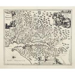
Nova Virginia Tabula.
A beautifully engraved map, derived from the highly influential map by Captain John Smith in 1612, showing Chesapeake Bay and the surrounding area.The decoration of this ...
Date: Amsterdam, 1671
Selling price: ????
Please login to see price!
Sold
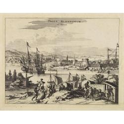
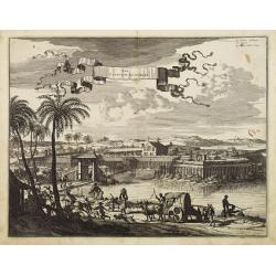
Pagus Hispanorum in Florida.
View of the port of St. Augustine, with ships and boats docked before the walled town, a few slaves and natives tending to their Spanish overlords.
Date: Amsterdam, 1671
Selling price: ????
Please login to see price!
Sold
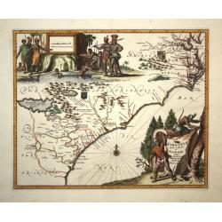
Arx Carolina.
View of the French settlement of Charles Fort, founded 1562 on Parris Island, Carolina, named after their king Charles IX.The garrison was captured three years later by t...
Date: Amsterdam, 1671
Selling price: ????
Please login to see price!
Sold
I. Tamaraca.
A superb view of the Dutch Forte Oranje on the Brazilian island of Itamaracá, with small-craft shipping and local products being hauled along the waterfront.A small lett...
Date: Amsterdam, 1671
Selling price: ????
Please login to see price!
Sold in 2008
Urbs Salvador.
Fine copper engraving of the walled city of San Salvador, with numbered key at the top.Ships and boats fill the harbor in the foreground.
Date: Amsterdam, 1671
Selling price: ????
Please login to see price!
Sold
Obsidio et Expugnatio Portus Calvi.
Copper engraving of the Dutch fort at Porto Calvo (Alagoas), with numbered key in the upper right corner.The foreground is filled with people, carts, and farmers. Title i...
Date: Amsterdam, 1671
Selling price: ????
Please login to see price!
Sold
Alagoa ad Austrum.
Superb view of Alagoa (Maceio) with native fishermen in the foreground and a religious procession in the background. A small letter key at the bottom left identifies majo...
Date: Amsterdam, 1671
Selling price: ????
Please login to see price!
Sold
Ostium Flumines Paraybae.
Fine copper engraving illustrating the entrance to the Paraiba River in Brazil. With small letter key in the upper left corner.In the left background is a large fort (Cas...
Date: Amsterdam, 1671
Selling price: ????
Please login to see price!
Sold in 2008
Castrum Mauritij ad Ripam Fluminis S. Francisci.
Impressing copper engraving depicting Fort Maurice, which controlled the ferry on the Rio Francisco.With small letter key at the bottom.
Date: Amsterdam, 1671
Selling price: ????
Please login to see price!
Sold
Olinda de Phernambuco.
View of the town of Olinda, north of present-day Recife in Pernambuco with extensive shipping in the foreground.With small letter key in the upper left corner.
Date: Amsterdam, 1671
Selling price: ????
Please login to see price!
Sold
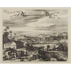
Serinhaim.
Fine view of a fort in Serinhaim, Brazil. With numbered key in the upper left corner and title enclosed in large ribbon banner style cartouche.A procession of Portuguese ...
Date: Amsterdam, 1671
Selling price: ????
Please login to see price!
Sold
Urbs Domingo in Hispaniola.
Attractive bird's eye view of old Santo Domingo with the Cathedral, the Ozama fortress and other monuments clearly identifiable.
Date: Amsterdam, 1671
Selling price: ????
Please login to see price!
Sold
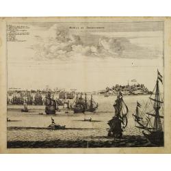
Havana.
Impressing copper engraving depicting the Havana harbour.
Date: Amsterdam, 1671
Selling price: ????
Please login to see price!
Sold
Cartagena.
Attractive view of the treasure port of Cartagena in what is now Colombia.A variety of boats and ships dominate the foreground with the town and its surroundings depicted...
Date: Amsterdam, 1671
Selling price: ????
Please login to see price!
Sold
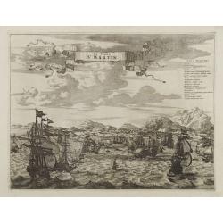
De Stadt St. Martin.
A view of the town of St. Maarten on the island St.-Martin/St. Maarten with a Dutch fleet in the foreground. Title ribbon in the sky, letter key in the upper right corner...
Date: Amsterdam, 1671
Selling price: ????
Please login to see price!
Sold
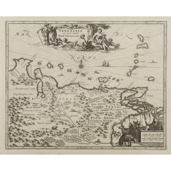
Venezuela cum parte Australi Novae Andalusiae.
Most decorative map with two large cartouches and compass-rose, large group of islands at the mouth of the Orinoco, other islands off Venezuela coast: Margarita, Aruba, C...
Date: Amsterdam, 1671
Selling price: ????
Please login to see price!
Sold
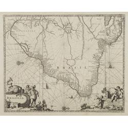
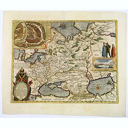
Brasila.
Map of Brazil extending from C. Nasou and Parime Lago to the Mouth of the Rio de la Plata.Oriented with West on top.The cartography of the region is quite primitive. The ...
Date: Amsterdam 1671
Selling price: ????
Please login to see price!
Sold
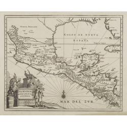
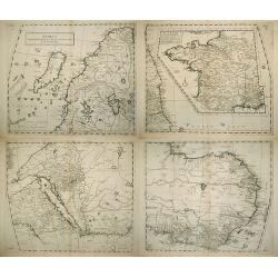
Nova Hispania Nova Galicia Guatimala
A fine map based on the cartography of Hessel Gerritsz. The map includes Mexico through Costa Rica with nice detail.Large pictorial cartouche depicting Native Americans l...
Date: Amsterdam, 1671
Selling price: ????
Please login to see price!
Sold
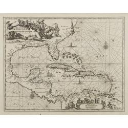
Insulae Americanae in Oceano Septentrionali..
A fine map of the West Indies based on the cartography of Hessel Gerritsz. Encompassing the eastern coast of North America from the Chesapeake through the Gulf of Mexico,...
Date: Amsterdam, 1671
Selling price: ????
Please login to see price!
Sold
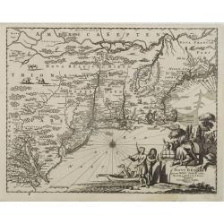
Novi Belgii quod nunc Novi Jorck..
A beautifully engraved map, derived from the highly influential map by Visscher. The decoration of this finely engraved map has in the lower right corner not longer a vie...
Date: Amsterdam, 1671
Selling price: ????
Please login to see price!
Sold
Tabula Magellanica qua tierrae del Fuego..
One of the most decorative maps of the extremity of South America, with Patagonia, the Straight of Magellan, Terra del Fuego and the discoveries made by LeMaire and Schou...
Date: Amsterdam, 1671
Selling price: ????
Please login to see price!
Sold
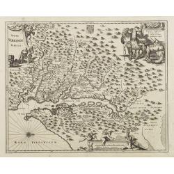
Nova Virginia Tabula.
A beautifully engraved map, derived from the highly influential map by Captain John Smith in 1612, showing Chesapeake Bay and the surrounding area.The decoration of this ...
Date: Amsterdam, 1671
Selling price: ????
Please login to see price!
Sold
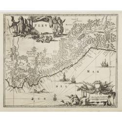
Peru.
Map of Peru from De Nieuwe en onbekende Weereld.. published by Arnold Montanus, which was used by John Ogilby as the basis of his Complete History of America.The map exte...
Date: Amsterdam, 1671
Selling price: ????
Please login to see price!
Sold
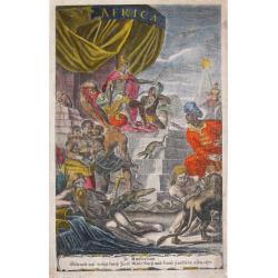
Africa.
The decorative frontispice of Olfert Dapper?s description of Africa.
Date: Amsterdam, 1671
Selling price: ????
Please login to see price!
Sold
Virginiae partis australis, et Floridae partis orientalis..
This striking map of the Southeast shows the French and English claims in the region marked with their respective coats of arms. The cartography in the southern part of t...
Date: London,1671
Selling price: ????
Please login to see price!
Sold in 2008

Americus Vesputius / Francisco Pisarro.
Arnoldus Montanus, writer of "De Nieuwe en Onbekende Weereld: of Beschryving van America", published by Jacob van Meurs. Two portraits of the discoverer of the ...
Date: Amsterdam, 1671
Selling price: ????
Please login to see price!
Sold
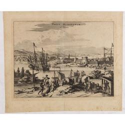
Pagus Hispanorum in Florida.
View of the port of St. Augustine, the oldest city in the United States and the northernmost bastion of the Spanish empire in America (Castillo de San Marcos). With ships...
Date: Amsterdam, 1671
Selling price: ????
Please login to see price!
Sold in 2020
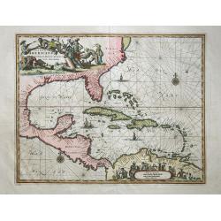
Insulae Americanae in Oceano Septentrionali,
Outstanding map of the West Indies that also incorporates the eastern coast of North America from the Chesapeake through the Gulf of Mexico, Central America and the north...
Date: London,1671
Selling price: ????
Please login to see price!
Sold in 2008
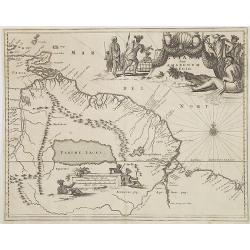
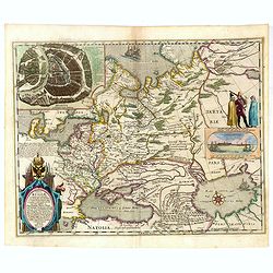
Guiana sive Amazonum Regio.
From : De Nieuwe en Onbekende Weereld published by Jacob van Meurs. Beautiful map of the Guyanas and Brazil, showing the course of the Amazon river and indicates the myth...
Date: Amsterdam, 1671
Selling price: ????
Please login to see price!
Sold in 2008
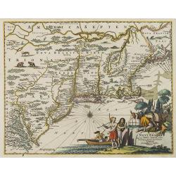
Novi Belgii quod nunc Novi Jorck vocatur, Novae q. Angliae & partis Virginiae . . .
A beautifully engraved map, derived from the highly influential map by Visscher. The decoration of this finely engraved map has in the lower right corner not longer a vie...
Date: Amsterdam, 1671
Selling price: ????
Please login to see price!
Sold in 2008
Africa Ioanne Baptista Nicolosio?
From: Hercules Siculus Sive Studium Geographicum ? Rome, 1670-71. (Second state).In 1652 the Propaganda Fide commissioned Giovanni Battista Nicolosi (1610-70) to produce ...
Date: Rome, 1671
Selling price: ????
Please login to see price!
Sold in 2010
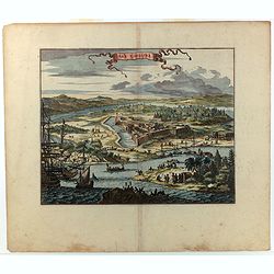
PAGUS HISPANORUM in Florida
Ogilby’s important early view of St. Augustine. With very decorative coloring. This view was originally drawn from Gerrit van Schagen’s work, and depicts a fictional...
Date: London, 1671
Selling price: ????
Please login to see price!
Sold in 2011
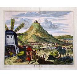
POTOSI
Decorative and highly detailed view of the City of Potosi, now the largest city in the Department of Potosi in Bolivia.Remarkable for its silver mines and the cathedral o...
Date: London, 1671
Selling price: ????
Please login to see price!
Sold in 2011
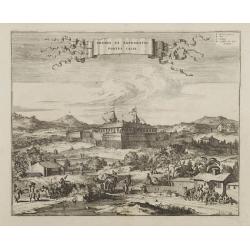
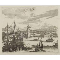
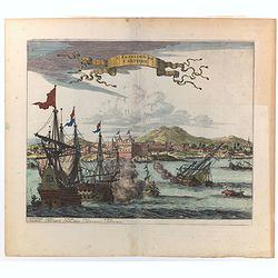
ARX NASSOVII
Early copper engraved view of the Fort Nassau, in Pernambuco, Brazil.Very decorative, with detailed sailing ships in the front, one firing its canons. The fort and villag...
Date: London, 1671
Selling price: ????
Please login to see price!
Sold in 2011
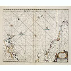
![[sea-chart of the Channel between England and France]](/uploads/cache/85520-250x250.jpg)
[sea-chart of the Channel between England and France]
A rare sea-chart of the Channel between England and France. Extends from Portsmouth until Dover in England, and Calais until Cherbourg in Normandy. A large inset map show...
Date: London, ca 1671
Selling price: ????
Please login to see price!
Sold in 2021
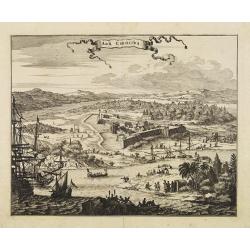
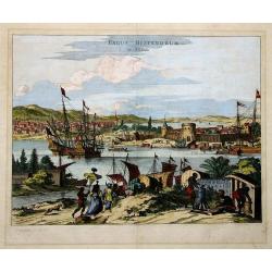
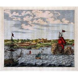
S. Salvador.
A very attractive copperplate engraving of the Brazilian city of San Salvador (Sao Salvador de Bahia de Todos os Santos / The Holy Saviour of the Bay of All Saints), in t...
Date: London, ca 1671
Selling price: ????
Please login to see price!
Sold in 2022
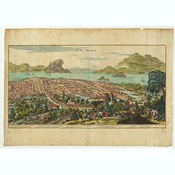
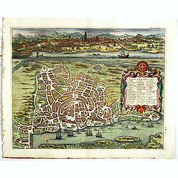
Nova Mexico.
This sweeping panorama of a walled Mexico City was the first published view to identify Tenochtitlan as Mexico City. This is one of the most important views of the great ...
Date: London, ca 1671
Selling price: ????
Please login to see price!
Sold in 2022
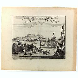
Truxillo.
A lovely copperplate view of Truxillo, situated on the northern coast of Honduras. The engraving shows a number of Spanish ships at anchor in the deep natural harbor, alo...
Date: London, ca 1671
Selling price: ????
Please login to see price!
Sold in 2022
St. Francisco de Campeche.
A delightful view of St. Francesco de Campeche in which a Dutch ship is firing and sinking a ship close by. Other, small craft are seen nearby. In the background a heavil...
Date: London, ca 1671
Selling price: ????
Please login to see price!
Sold in 2022
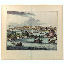
Cartagena.
A richly colored view of what was at the time one of the most important and largest cities in Spanish America. As a result, Cartagena was heavily defended, as is evidence...
Date: London, ca 1671
Selling price: ????
Please login to see price!
Sold in 2022
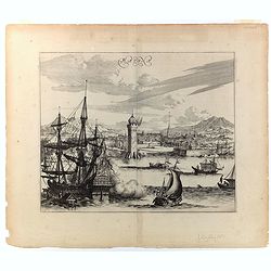
Havana.
This wonderful engraving is a superb example of Ogilby's city views. Although it is a spectacular and lively composition, the image is a little inaccurate in detail. In t...
Date: London, ca 1671
Selling price: ????
Please login to see price!
Sold in 2022
Arx Carolina.
A superb 17th century copperplate engraving displaying Fort Carole and its surrounds on the St. John's River in Florida. It is situated in what today is Jacksonville, in ...
Date: London, ca 1671
Selling price: ????
Please login to see price!
Sold in 2022
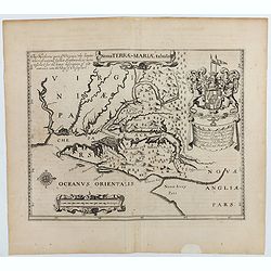
Nova terrae-Mariae tabula.
Double-page engraved map of Chesapeake Bay region, with west oriented at the top, the first printed map of Maryland. Perhaps prepared by Jerome Hawley and John Lewgerand ...
Date: London, ca 1671
Selling price: ????
Please login to see price!
Sold in 2023
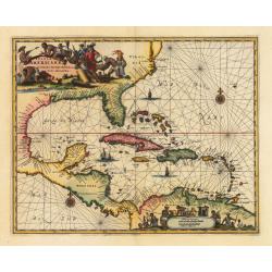
Insulae Americanae in Oceano Septentrionali cum Terris adiacentibus
A fine example of John Ogilby's map of the West Indies, based on Hessel Gerritaz’ chart of 1631 and Blaeu's map of 1635, and Janssons map of 1636. Florida is depicted...
Date: London, 1671
Selling price: ????
Please login to see price!
Sold in 2023
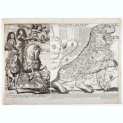
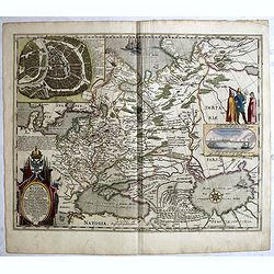
Le Lion Belgique des Pais Bas contenant les XVII Provinces.
The rare third state, of six, ofthis scarce Leo Belgicus map, of which Van der Heijden only lists 2 other examples. With the publisher's name "Lagnet" in lower ...
Date: Paris, between 1668 - 1672
Selling price: ????
Please login to see price!
Sold in 2020
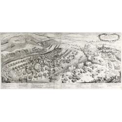
La battaglia di Nordlingen.
Rare, detailed plan of the Battle of Nördlingen (1634). The Battle of Nördlingen took place on 6 September 1634 during the Thirty Years' War. A combined Imperial-Spanis...
Date: Vienna, 1672
Selling price: ????
Please login to see price!
Sold in 2023
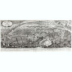
Battaglia di Lutzen
Rare, detailed plan of the Battle of Lützen (6 November 1632) This battle is considered one of the most important battles of the Thirty Years' War. An army led by Swedis...
Date: Vienna, 1672
Selling price: ????
Please login to see price!
Sold in 2023
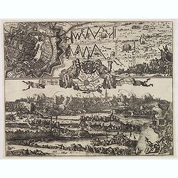
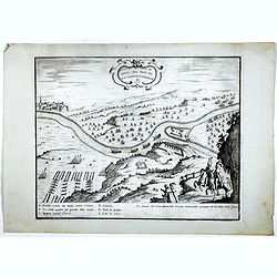
De Belegringh van Groeningen.
Very rare separately issued print of the siege Groningen. Upper left plan of Groningen, in the center a map of the surrounding areas, the city arms above and on each side...
Date: Amsterdam, Marcus Doornik, ca.1672
Selling price: ????
Please login to see price!
Sold in 2013
.Pascaerte vande Vlaemsche, Soute, en Caribesche Eylanden, als mede Terra Nova,. . .
This fine and scarce sea chart covers the central Atlantic and extends to include the Maritime Provinces, Antilles and the northwest coast of South America, east to the A...
Date: Amsterdam, 1672
Selling price: ????
Please login to see price!
Sold in 2013

Pascaerte vande Vlaemsche, Soute, en Caribesche Eylanden, als mede Terra Nova,. . .
This fine and scarce sea chart covers the central Atlantic and extends to include the Maritime Provinces, Antilles and the northwest coast of South America, east to the A...
Date: Amsterdam, 1672
Selling price: ????
Please login to see price!
Sold in 2024
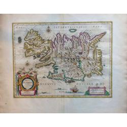
Tabula Islandiae Auctore Georgio Carolo Flandro.
A fascinating and very beautiful map of Iceland by Willem Janszoon Blaeu based on the work of Juris Carolus.Carolus was a Dutch traveler who probably derived his 1620s ma...
Date: Amsterdam, ca. 1672
Selling price: ????
Please login to see price!
Sold in 2015
Vera delineatio civitatis Bassoræ : Nec non Fluviorum, Insularum Oppidorum pagorum et terrarum ei adiacentium, inquibus passim habitant familiæ sabaorum Siue Mendaiorum, qui vulgo vocantur christiani sti. Joannis.
Rare map of the Tigris and Euphrates rivers in the area surrounding modern-day Basra published from 1672 onwards in "Relations de Divers Voyages Curieux" by the...
Date: Paris, 1672
Selling price: ????
Please login to see price!
Sold in 2015
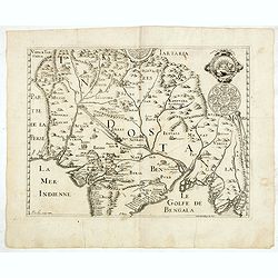
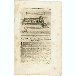
Description de la partie des Indes orientales qui est sous la domination du grand Mogol.
An early map showing the northern part map of part of India, centered on Agra, extending from Afghanistan to Bengal and from Tartary to the Deccan. Published from 1672 on...
Date: Paris, 1672
Selling price: ????
Please login to see price!
Sold in 2015
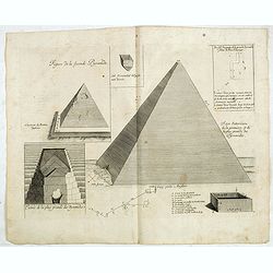
Figure de la seconde Pyramide.
An early print of a pyramid published from 1672 onwards in "Relations de Divers Voyages Curieux" by the French geographer, Melchisédech Thévenot. Thévenot's ...
Date: Paris, 1672
Selling price: ????
Please login to see price!
Sold in 2016
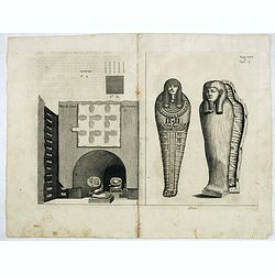
Plan de Caves des mummies.
An early print of mummies in Cairo published from 1672 onwards in "Relations de Divers Voyages Curieux" by the French geographer, Melchisédech Thévenot. Thév...
Date: Paris, 1672
Selling price: ????
Please login to see price!
Sold in 2015
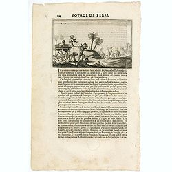
Cette figure represente un Retranchement que sirent les gens d'un Vaisseau Hollandois, qui eschoüa proche Damon, dont Rhoe parle dans ses memoires.
An early print showing Dutch ships arriving at Surat according to the memoirs of the English diplomat Thomas Roe (c. 1581 – 6 November 1644). Published from 1672 onward...
Date: Paris, 1672
Selling price: ????
Please login to see price!
Sold in 2015

Portraits copiees sur les orginaus soits par le Peintre du Mogol.
An early text engraving showing Mogol paintings, published from 1672 onwards in "Relations de Divers Voyages Curieux" by the French geographer, Melchisédech Th...
Date: Paris, 1672
Selling price: ????
Please login to see price!
Sold in 2015
(Scene in India)
An early text engraving published from 1672 onwards in "Relations de Divers Voyages Curieux" by the French geographer, Melchisédech Thévenot. Thévenot's work...
Date: Paris, 1672
Selling price: ????
Please login to see price!
Sold in 2015
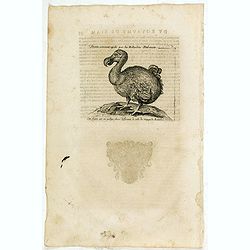
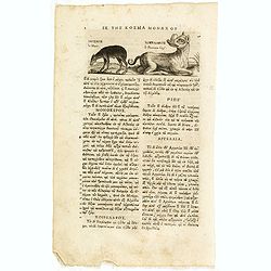
Dronte, autrement appellé par les Hollandois Dod-aers.
An early text engraving of a Dodo who Willem Ysbrandtszoon Bontekoe claimed to have seen on Réunion and published from 1672 onwards in "Relations de Divers Voyages ...
Date: Paris, 1672
Selling price: ????
Please login to see price!
Sold in 2015
Dronte Alijs Dod-Aers.
An early text engraving of a Dodo who Willem Ysbrandtszoon Bontekoe claimed to have seen on Réunion and published from 1672 onwards in "Relations de Divers Voyages ...
Date: Paris, 1672
Selling price: ????
Please login to see price!
Sold in 2015
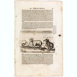
Le Musc. le Pourceau-cerf.
An early text engraving of a musk-deer and a babirusas, also called pig-deer published from 1672 onwards in "Relations de Divers Voyages Curieux" by the French ...
Date: Paris, 1672
Selling price: ????
Please login to see price!
Sold in 2015
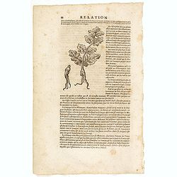
(Wood cut f a ginseng plant)
An early wood block engraving of a ginseng plant with a description by Thévenot citing Martini's explanation that "ginseng" was derived from ren (person). From...
Date: Paris, 1672
Selling price: ????
Please login to see price!
Sold in 2015
Tabula Russiae ex autographo, quod delineandum curavit Foedor filius Tzaris Boris desums... - Domino regionum Iueriae Kartalinie et Groefiniae Tzari etc: dedicata ab Heselo Gerardo M.DC.XIIII
A re-issue, by Willem Blaeu, of Hessel Gerritsz' rare and influential map of Russia. Dutch text on verso, extending west to east from Emden to Aspachan and north to south...
Date: Amsterdam, 1659-1672
Selling price: ????
Please login to see price!
Sold in 2016
Tabula Russiae ex autographo, quod delineandum curavit Foedor filius Tzaris Boris desums... - Domino regionum Iueriae Kartalinie et Groefiniae Tzari etc: dedicata ab Heselo Gerardo M.DC.XIIII
A re-issue, by Willem Blaeu, of Hessel Gerritsz' rare and influential map of Russia. Dutch text on verso, extending west to east from Emden to Aspachan and north to south...
Date: Amsterdam, 1659-1672
Selling price: ????
Please login to see price!
Sold in 2017
DISSEGNO DEL FORTE DI MONTE SPIZ PRESO DAL GRAN MARESCIALLE LUBOMIRSCHI.
An etching shows the Polish military leader and nobleman Jerzy Sebastian Lubomirski (1616–1667) above the fortress Biala Góra (here marked in Italian as Monte Spiz and...
Date: Vienna, J.B. Hacque 1672
Selling price: ????
Please login to see price!
Sold in 2016
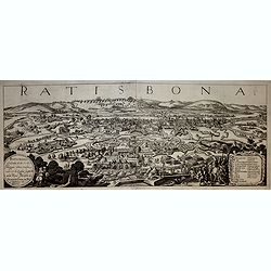
Ratisbona (Regensburg)
A rare and very decorative town-view of Regendsburg showing the siege of 1634.Gualdo Priorato (1606-1678) entered military service at a very young age and served in Fland...
Date: Vienna, 1672
Selling price: ????
Please login to see price!
Sold in 2019
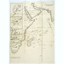
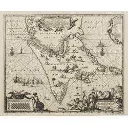
Joao Teixeira Cosographo de sua Magestade.
An early issue of this important map of the Indian Ocean was prepared by Joao Teixeira, a well-known and respected Portuguese chart maker. He produced this wonderful sea ...
Date: Paris ca. 1672
Selling price: ????
Please login to see price!
Sold in 2017
Goa.
A combined panoramic and bird's eye-view of Goa, the main Portuguese trading post in India. From Philippus Baldaeus "Naauwkeurige Beschryvinge Van Malabar en Choroma...
Date: Amsterdam, 1672
Selling price: ????
Please login to see price!
Sold in 2017
Tabula Russiae ex autographo, quod delineandum curavit Foedor filius Tzaris Boris desums... - Domino regionum Iueriae Kartalinie et Groefiniae Tzari etc: dedicata ab Heselo Gerardo M.DC.XIIII
A re-issue, by Willem Blaeu, of Hessel Gerritsz' rare and influential map of Russia.Spanish text on verso, extending west to east from Emden to Aspachan and north to sout...
Date: Amsterdam, 1659-1672
Selling price: ????
Please login to see price!
Sold in 2017

Tabula Russiae ex autographo, quod delineandum curavit Foedor filius Tzaris Boris desums... - Domino regionum Iueriae Kartalinie et Groefiniae Tzari etc: dedicata ab Heselo Gerardo M.DC.XIIII
A re-issue, by Willem Blaeu, of Hessel Gerritsz' rare and influential map of Russia. Dutch text on verso, extending west to east from Emden to Aspachan and north to south...
Date: Amsterdam, 1659-1672
Selling price: ????
Please login to see price!
Sold in 2019