Browse Listings
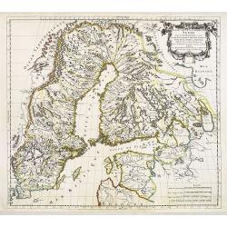
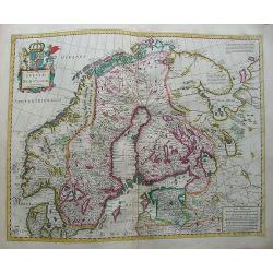
Estats de la Couronne de Suede dans la Scandinavie, ou Sont Suede, Gotlande, Lapponie Suedoise, Finlande, Ingrie et Livonie Subdivisées en leurs Provinces . . .
Attractive map of Sweden, Finland and the Baltic States
Date: Paris, Marriette, 1669
Selling price: ????
Please login to see price!
Sold
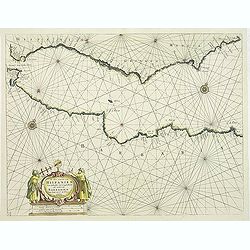
De Zee Custen van Hispanien Van Gibraltar tot Caep S. Martin, als mede van Barbarien Van Seute tot C. de Tenes.
Fine of the Strait of Gibraltar and the westernmost Mediterranean. Large title cartouche featuring two seamen using navigation instruments. Rhumb lines and two compass r...
Date: Amsterdam, 1669
Selling price: ????
Please login to see price!
Sold in 2011
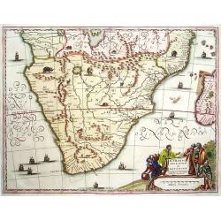
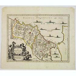
Aethiopia inferior vel Exterior.
The standard map of South Africa throughout the 17th century covering the region from Congo-Zanzibar to the Cape. Based on the map of Portuguese exploration and most deta...
Date: Amsterdam 1670
Selling price: ????
Please login to see price!
Sold
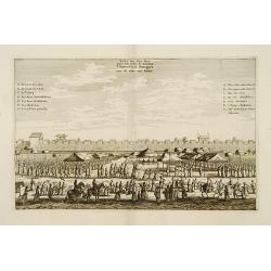
Festin des Vice-rois pres des murs de Kanton.
Decorative print showing the arrival of the Dutch Embassy of the V.O.C. at Canton.From Olfert Dapper mission to China, 1662-1663. Printed by Jacob van Meurs, title of the...
Date: Amsterdam 1670
Selling price: ????
Please login to see price!
Sold
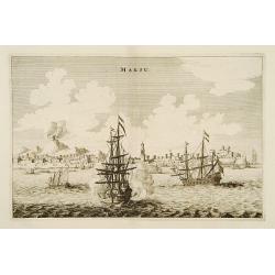
Makou.
From Olfert Dapper mission to China, 1662-1663. Printed by Jacob van Meurs, title of the book: Gedenckwaerdig bedrijf der Nederlandsche Oost-Indische Maetschappye, op de ...
Date: Amsterdam 1670
Selling price: ????
Please login to see price!
Sold
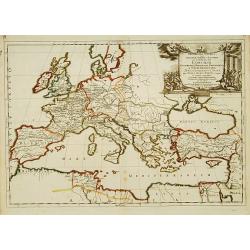
Concilia Oeucumenica Nationalia Provincialia ..
A fine map of Europe and Near East, depicting a geographic representations of Church history.Prepared by Guillaume Sanson (1633-1703), the son of Nicolas Sanson.Published...
Date: Paris 1670
Selling price: ????
Please login to see price!
Sold
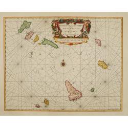
Insulae de Cabo Verde olim Hesperides sive .. Zoute Eylanden.
A beautiful sea chart of these important islands. The map is a re-issue of the map by J.Janssonius. Beautifully embellished with rhumb lines, compass rose and cartouche.
Date: Amsterdam 1670
Selling price: ????
Please login to see price!
Sold
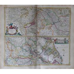
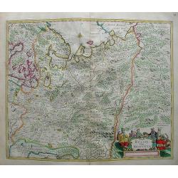
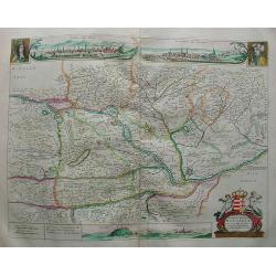
Totius Fluminis Rheni Novissima Descriptio.
Two maps on one sheet of the river Rhine. Original colored map following the river from Germany to the North Sea.
Date: Amsterdam, 1670
Selling price: ????
Please login to see price!
Sold in 2013
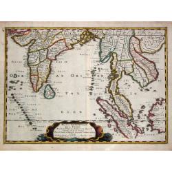
Partie meridionale de l'' Inde En deux Presqu'' Isles l'' une deçà et l'' autre delà Gange. 1654.
Nicolas Sanson?s map of southern Asia with the Indian subcontinent, Indochina, Malaysia, Sumatra and western Borneo.Nicolas Sanson (1600-67), "father of the French c...
Date: Paris, 1658-1670
Selling price: ????
Please login to see price!
Sold in 2016

Regnum Bohemia, eique Annexae provinciae uit Ducatus Silesia, Marchionatus Moravia et Lusatia.
Frederick de Wit (1610-1698) became after the closing of the Blaeu firm one of the most important Amsterdam-based publishers. He published several atlases, Atlas Minor (1...
Date: Amsterdam, c. 1670
Selling price: ????
Please login to see price!
Sold in 2009
Ducatuum Livoniae et Curlandiae.
Nice engraved map of Estonia and Lithuania and parts of Russia. Decorative title cartouche supported by cherubs in the upper left corner.
Date: Amsterdam ca 1670
Selling price: ????
Please login to see price!
Sold
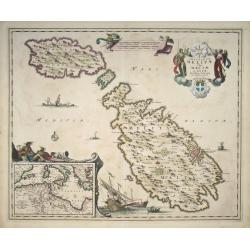
Insularum Melitae vulgo Maltae et Gozae Novissima Delineatio per Nicolaum Visscher
Map of the islands Malta, Comino and Gozo by Nicolas Visscher. Inset map in the bottom left corner shows the Mediterranean. The original coloring is nice and crisp.
Date: Amsterdam, c. 1670
Selling price: ????
Please login to see price!
Sold in 2008
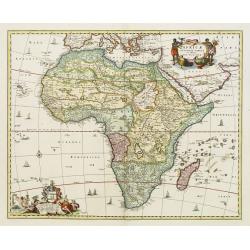
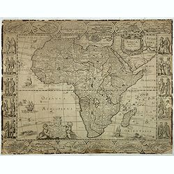
Africae accurata tabula ex officina Nic. Visscher.
Fine map of the continent of Africa filled with mythical towns, rivers, and mountains and continues to reflect the Ptolemaic view of Africa. A title cartouche in upper ig...
Date: Amsterdam, 1670
Selling price: ????
Please login to see price!
Sold in 2018
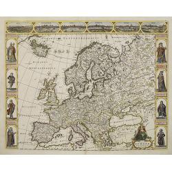
Nova europae descriptio.
An attractive carte à figures map of the European continent. In the top there are six views of : Rome, Amsterdam, Paris, London, Seville and Prague. At both sides there ...
Date: Amsterdam, 1670
Selling price: ????
Please login to see price!
Sold in 2011
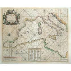
Paskaert van 't Westelycke deel Der Middelandsche Zee . . .
Doncker's map of the Western Mediterranean, from Doncker's rare Nieuw Groot Sturmaans Straets-Book, published in Amsterdam. Doncker's sea charts are among the earliest an...
Date: Amsterdam, 1670
Selling price: ????
Please login to see price!
Sold in 2021

POLOGNE Royaume Electif.
Nice miniature map of Poland.
Date: Paris, 1670
Selling price: ????
Please login to see price!
Sold in 2008
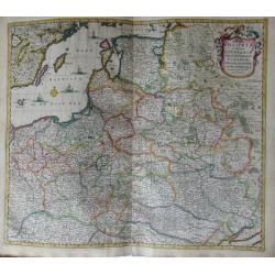
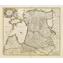
Regni Poloniae et Ducatus Lithuaniae Voliniae, Podoliae Ucraniae Prussiae, Livoniae, et Curlandiae descriptio.
Attractive original hand-colored map of Poland, Belarus, Ukraine, and the Baltic countries. The map is decorated with a cartouche and there are sailing ships in the Balti...
Date: Amsterdam, 1670
Selling price: ????
Please login to see price!
Sold in 2012
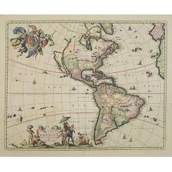
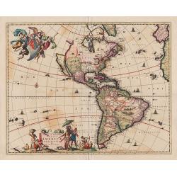
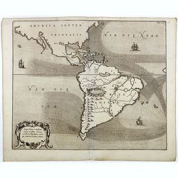
Novissima et Accuratissima Totius Americae Descriptio.
Visscher\'s map of the Americas, this decorative map greatly influenced the cartography of the Americas both geographically and artistically.Although it did not provide m...
Date: Amsterdam, 1670
Selling price: ????
Please login to see price!
Sold in 2009
![[ Set of 2 maps ] Abbregé de la Carte de la Chine du R.P. Martinius Jesuiste / du R.P. Bouyn Jesuiste.](/uploads/cache/90965-250x250.jpg)
[ Set of 2 maps ] Abbregé de la Carte de la Chine du R.P. Martinius Jesuiste / du R.P. Bouyn Jesuiste.
Extremely rare set of maps by Nicolas Sanson. Unlike most mapmakers, who readily adopted Martini’s map of China after it appeared in Blaeu's Novus Atlas Sinensis in 165...
Date: Paris, 1670
Selling price: ????
Please login to see price!
Sold in 2009
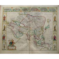
Asiae nova descriptio.
An attracting "carte à figures" map of the Asian continent. In the top there are six views of: Ormus, Aden, Jerusalem, Damasco, Rodus and Famgusta. At both sid...
Date: Amsterdam, 1670
Selling price: ????
Please login to see price!
Sold in 2010
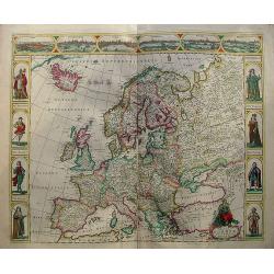
Nova europae descriptio.
An attracting "carte à figures" map of the European continent. In the top there are six views of: Roma, Amsterodamum, Paris, Londinum, Sivilla and Praga. At bo...
Date: Amsterdam, 1670
Selling price: ????
Please login to see price!
Sold in 2010
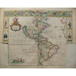
Nova totius americae descriptio.
Very rare continent map of the America's. The map is not dated on the map, but it is from approx 1670.It is a rare map because it has never been issued in a regular atlas...
Date: Amsterdam, 1670
Selling price: ????
Please login to see price!
Sold in 2012
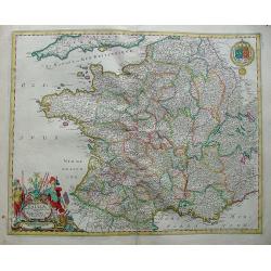
Galliae nova et accurata descriptio vulgo royaume de france.
Standard map of France.
Date: Amsterdam, 1670
Selling price: ????
Please login to see price!
Sold in 2010
Tabula Regnorum Sueciae et Norvegiae.
Map of Sweden and Norway form a composition atlas from ca 1670.
Date: Amsterdam, 1670
Selling price: ????
Please login to see price!
Sold in 2009
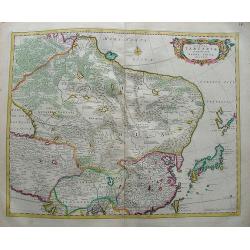
Tabula Russia Vulgo Moscovia.
A detailed map including all western Russia and most of Finland. With very decorative title cartouche.
Date: Amsterdam, 1670
Selling price: ????
Please login to see price!
Sold in 2009
Tabula Tartariae et majoris partis regni Chinae.
Map of China With Japan.
Date: Amsterdam, 1670
Selling price: ????
Please login to see price!
Sold in 2013
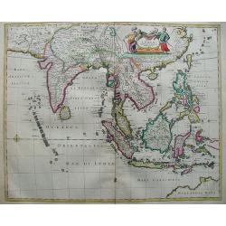
Tabula Indiae Orientalis.
The map shows from southeastern Persia to northwestern Australia. Focus is on India, Southeast Asia, and the East Indies with the Philippines. The many islands are clearl...
Date: Amsterdam, 1670
Selling price: ????
Please login to see price!
Sold in 2012
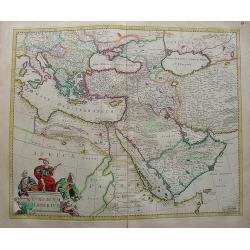
Nova Persiae Armeniae Natoliae et Arabiae.
Decorative map of Persia with Cyprus.
Date: Amsterdam, 1670
Selling price: ????
Please login to see price!
Sold in 2010
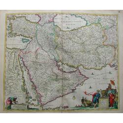
Turicum Imperium.
Attractive map of Turkey, Arabia, Persia and the east Mediterranean region, including Cyprus.
Date: Amsterdam, 1670
Selling price: ????
Please login to see price!
Sold in 2010
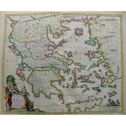
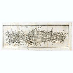
Hellas (in Greek) seu Graecia Universa.
Nice and bright map of Greece with the biggest part of Crete (Candia).
Date: Amsterdam, 1670
Selling price: ????
Please login to see price!
Sold in 2010
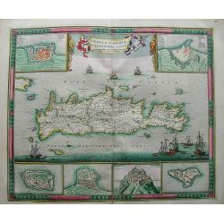
Insula Candia Ejusque Fortificatio.
Nice map of Crete (candia) with inset maps of Canea, Candia, Suda, Thise, Retimo and Spina Longa in an unusual fresh color.The map is in a strictly contemporary coloring ...
Date: Amsterdam, 1670
Selling price: ????
Please login to see price!
Sold in 2013
Novissima et emendata delineatio Hungariae una cum adjacentibus et finitimis regionibus.
Map Hungary with very nice insets of Buda (Buda vulgo Ofen) and Pest (Pesth)(Posoniensis vulgo Presburg) in the top with a portrait on both sides.At the bottom there are ...
Date: Amsterdam, 1670
Selling price: ????
Please login to see price!
Sold in 2009
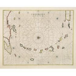
Canibales Insulae.
This is the first Dutch chart to focus on the Lesser Antilles. It covers the Windward and Leeward Isles from Puerto Rico to Trinidad and Margarita. Centered on a compass ...
Date: Amsterdam, 1670
Selling price: ????
Please login to see price!
Sold in 2019

Ibraim Pascia Visiragha di Giannizzari. (Portrait of Ibrahim Pasha)
Fine, decorative and very scarce copper engraved portrait of Ibrahim Pasha, Pargali Ibrahim Pasha (1493 or 1494–1536), also known as Frenk Ibrahim Pasha (the "West...
Date: Vienna, Gio. Battista Hacque, 1670
Selling price: ????
Please login to see price!
Sold in 2010
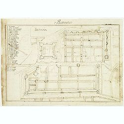
Batavia.
Manuscript town-plan of Batavia, nowadays Jakarta, as it was at about 1639, by which time the part of the town on the western bank of the Ciliwung had already been laid o...
Date: France, 1650- 1670
Selling price: ????
Please login to see price!
Sold in 2011
Fezzae et Marocchi Regna Africae Celeberrima.
A lovely example of John Ogilby's map of Fez and Morocco in north Africa, published in London during the second half of the 17th century. North is orientated to the left,...
Date: London, 1670
Selling price: ????
Please login to see price!
Sold in 2020
Carta del Regno di Candia.
Scarce map of Crete from "Historia di Leopoldo Cesare" by Galeazzo Gualdo Priorato. The map is after a map by Marco Boschini but less detailed in island place-n...
Date: Vienna, 1670
Selling price: ????
Please login to see price!
Sold in 2020
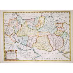
Description de L'Empire du Sophi des Perses. . .
A map of Persia from Sanson's atlas "Cartes générales de toutes les parties du Monde". Including the Middle East and the area between the Black Sea and the Ca...
Date: Paris, 1658-1670
Selling price: ????
Please login to see price!
Sold in 2021

Hercules killing the Hydra.
Hercules killing the Hydra - Hercule tuant m'hydre - From a series of prints with as subject : The Labuors of Hercules. printmaker: Gilles Rousselet (Signed on print show...
Date: 1620-1670
Selling price: ????
Please login to see price!
Sold in 2021
![[Lot of 4 maps] Comitatus Hollandiae Tabula Pluribus Locus Recens Emendata a Nicolao Visscher.](/uploads/cache/18172-250x250.jpg)
[Lot of 4 maps] Comitatus Hollandiae Tabula Pluribus Locus Recens Emendata a Nicolao Visscher.
The fourth state (of 5) of Claes Jansz. Visscher's attractive map of Holland, published by his grand-son Nicolaas II. Embellished with a cartouche with the coat-of-ar...
Date: Amsterdam, ca. 1670
Selling price: ????
Please login to see price!
Sold in 2022
![[Lot of 2 maps] Perigrinatie ofte Veertich-Jarige Reyse der Kinderen Israëls.](/uploads/cache/20401-(2)-250x250.jpg)
[Lot of 2 maps] Perigrinatie ofte Veertich-Jarige Reyse der Kinderen Israëls.
Perigrinatie ofte Veertich-Jarige Reyse der Kinderen Israëls, Uyt Egypten door de Roode Zee, ende Woestyne, tot in 't Beloofde Land Canaan.Middelantsche Zee in den Bijb...
Date: Amsterdam, c. 1670
Selling price: ????
Please login to see price!
Sold in 2023
![[Japan, Imperial Palace Kyoto]](/uploads/cache/86190-250x250.jpg)
[Japan, Imperial Palace Kyoto]
A copper engraved view of a Dutch Embassy at the Japanese Imperial Palace in Kyoto. Rare to be found in fine contempory coloring. From Ogilby's translation of Montanus's ...
Date: London, 1670
Selling price: ????
Please login to see price!
Sold in 2022
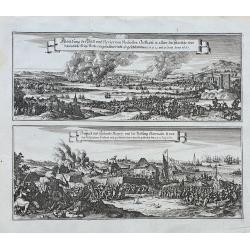
Abbildung der Statt und Revier von Rochester, Chetham...
Two views of the Dutch raid on the Medway in June 1667 during the Second Anglo-Dutch War, published in Merian's monumental Theatrum Europaeum. The scenes are drawn in gr...
Date: Frankfurt, ca. 1670
Selling price: ????
Please login to see price!
Sold in 2022
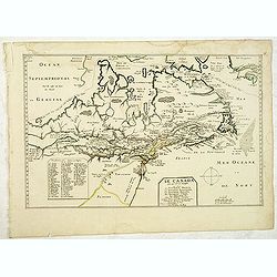
Le Canada faict par le Sr. de Champlain. ou sont La Nouvelle France, La Nouvelle Angleterre, La Nouvelle Holande, La Nouvelle Suede, La Virginie &c. . . .
The very rare 5th state with additional place names as Boston, Manhate (Manhattan), Montreal, Quebec and Port Royal, which are not present in State 4 (circa 1664) and by ...
Date: Paris, 1670
Selling price: ????
Please login to see price!
Sold in 2012
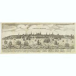
Amstelredam.
Decorative panoramic of Amsterdam, published by Marcus Willemsz. Doornick (1633 - 1703). With extensive shipping on the IJ. Underneath the engraving extensive text : Ams...
Date: Amsterdam, 1670
Selling price: ????
Please login to see price!
Sold in 2012
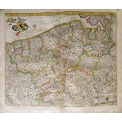
Comitatus Flandria Tabula, in Lucem Edita a Frederico de Wit ...
Attractive map of Flanders.
Date: Amsterdam, 1670
Selling price: ????
Please login to see price!
Sold in 2012
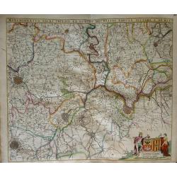
Marchionatus sacri imperii et dominii mechelini tabula...
Map of the belgion region of Mechelen.
Date: Amsterdam, 1670
Selling price: ????
Please login to see price!
Sold in 2012
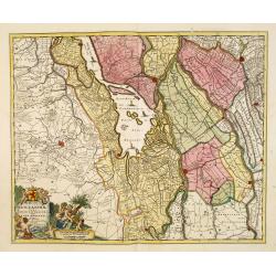
Hollandiae pars Meridionalior vulgo Zuyd-Holland.
Detailed map covering the area around the Biesbos, including Breda, Dordrecht, Gorcum and Gouda.Cartouches with later color addition.
Date: Amsterdam, 1670
Selling price: ????
Please login to see price!
Sold in 2012
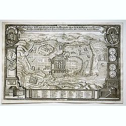
Eigentlicher Situs und Grundt Riss.. Statt Jerusalem...
Scarce bird's-eye imaginary plan of Jerusalem after Juan Bautista Villalpando (1552-1608) . In top left a portrait of King David and upper right a portrait of Salomon. Wi...
Date: Wittenberg, B.C. Wust, 1670
Selling price: ????
Please login to see price!
Sold in 2013
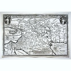
Land Tafel darumumen die Gegendt des Paradijss das Land Canaan. . .
Scarce map of Canaan, which is an early name for what is often called Israel or Palestine. It extends along the coast of the eastern Mediterranean.Georg Andreas Böckler ...
Date: Wittenberg, B.C. Wust, 1670
Selling price: ????
Please login to see price!
Sold in 2015
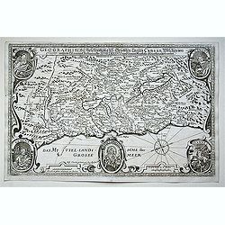
Geographische Beschreibung dess Gelobten Landes Canaan. . .
Scarce map of Canaan, with portraits of the Apostles of Matheaus, S. Marcus, S. Lucas, S. Johannes. With Christ in lower part. The map extends along the coast of the east...
Date: Wittenberg, B.C. Wust, 1670
Selling price: ????
Please login to see price!
Sold in 2013
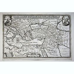
Geographische Beschreibung des Gelobten Landt Schaften welche die Aposteln und sonderlich Paulus durchraiset. . .
Scarce map of the Near East with in top portraits of the Apostles Petrus and Paulus.Georg Andreas Böckler (ca. 1617–1687) was a German architect and engineer.From: Bib...
Date: Wittenberg, B.C. Wust, 1670
Selling price: ????
Please login to see price!
Sold in 2015
Novissima et Accuratissima Totius Americae Descriptio.
Visscher's map of the Americas, this decorative map greatly influenced the cartography of the Americas both geographically and artistically.Although it did not provide mu...
Date: Amsterdam, 1670
Selling price: ????
Please login to see price!
Sold in 2013
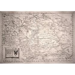
A Mapp of the Estates of the The Great Duke of Russia Blanch, or Moscovia.
A good example of Richard Blome's scarce map of Russia, the earliest folio sized map of the region to be engraved in England. The map has the naïve engraving style chara...
Date: London,1670
Selling price: ????
Please login to see price!
Sold in 2014
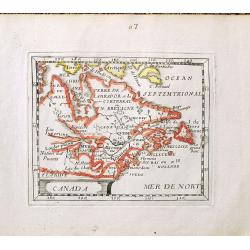
Canada.
The FIRST STATE of an uncommon miniature 17th c map of Canada, the Great Lakes and the east coast of America. Published in La Monde ou la Geographie Universalle in 1670 a...
Date: Paris, 1670
Selling price: ????
Please login to see price!
Sold in 2014
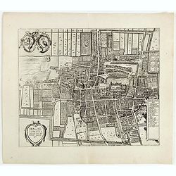
Hagae Comitis celeberrimi totius Europae municipij typus.
The bird's-eye view plan of The Hague from the rare Janssonius edition of his Town book. The city is seen from the southwest and shows an impressive unfortified residenti...
Date: Amsterdam, 1670
Selling price: ????
Please login to see price!
Sold in 2015
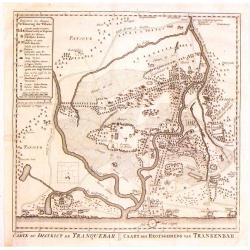
Carte du District de Tranquebar / Caart des Regtsgebieds van Trankenbar.
Fine detailed plan of the area around Trabquebar which is now Tharangambadi, India. This was a Danish trading colony in the state of Tamil Nadu.
Date: Amsterdam, 1670
Selling price: ????
Please login to see price!
Sold in 2016
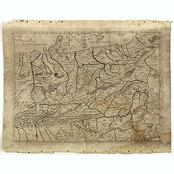
Germaniae Omniumque eius provinciarum, atque Austriae, Boemiae, Ungariae, Carinthiae, Corvatiae, Poloniae, Moraviae, Bossinae, Serviae, Prussiae, Masoviae, Transilvaniae, Lithuaniae, Russiae,. . .
ONLY KNOWN IN ONE OTHER EXAMPLE : Map of Poland and Eastern Europe, originally prepared by Ferrando Bertelli (1491) and was reprinted in 1583 by Donato Bertelli - the onl...
Date: Basano, 1491-1670
Selling price: ????
Please login to see price!
Sold in 2016

Course de Festes et Disposition des Cinq Quadrilles...
An early and intriguing engraving recording one of the most celebrated and spectacular festivals held at Paris by the young Louis XIV. The multi-day tournament took place...
Date: Paris, imprimerie royale, 1670
Selling price: ????
Please login to see price!
Sold in 2017
Mappa Fluxus et reflxurationes in Isthmus America . . .
Very unusual map depicting all of South America and most of North America. The map is total devoid of political detail with the exception that the floating city of Mexico...
Date: Leiden, 1670
Selling price: ????
Please login to see price!
Sold in 2016
Africae nova Tabula Auct. Jud. Hundio.
This very rare map of the African continent contains a dedication to the Marchese Andrea Paleotti and his wife Christine Dudley who was the granddaughter of Sir Robert Du...
Date: Bologna, c. 1670
Selling price: ????
Please login to see price!
Sold in 2017
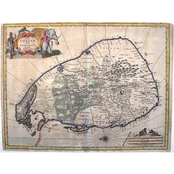
Insula Ceylan olim Taprobana nunc incolis Lankawn.
This rare map by Baldeus is show the island of Ceylon, oriented with east at the top. Two decorative cartousche embellish the map, which -a rarity for the time - shows de...
Date: Amsterdam, ca 1670
Selling price: ????
Please login to see price!
Sold in 2017
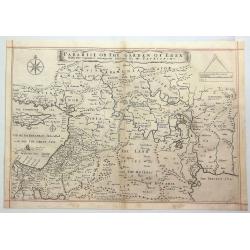
Paradise or the Garden of Eden with the Countries Circumjacent Inhabited by the Patriarchs.
An attractive, detailed map of the middle East region around the Paradise and Garden of Eden, extending from Cyprus to the Persian Sea. The Garden of Eden is located in t...
Date: Amsterdam, ca. 1670
Selling price: ????
Please login to see price!
Sold in 2020
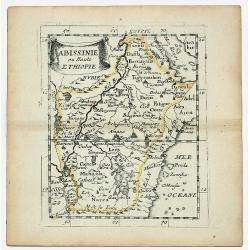
ABISSINIE ou Haute ETHIOPIE.
Nubie old, outlined colored historical miniature map of Abyssinie in north Ethiopia. The map is copperplate engraved with hand coloring and in very good condition and pu...
Date: Paris 1670
Selling price: ????
Please login to see price!
Sold in 2020
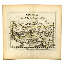
NIGRITIE. Par P. Du VAL Geogr du Roy.
Miniature map of west coast of Africa, showin Guinee, Sahara desert, Congo, Niger, etc.
Date: Paris, c 1670
Selling price: ????
Please login to see price!
Sold in 2020
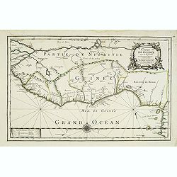
Costes de Guinée avec les Royaumes qui y sont connus des Européens, au-dedans des terres, selonn les relations les plus nouvelles . . .
Uncommon map of the Guinea, with fine title cartouche upper right . Dated 1671 and without the inset map added in 1677.
Date: Paris, 1671
Selling price: ????
Please login to see price!
Sold
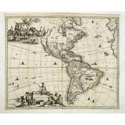
Novissima et Accuratissima Totius Americae Descriptio.
Nice dark impression of John Ogilby's decorative map of America and the Pacific, including New Zealand and California as an island.Engraved by Francis Lamb. Ogilby's map ...
Date: London, 1671
Selling price: ????
Please login to see price!
Sold in 2012
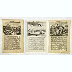
Novum Amsterodamum. . . (together with 2 other scenes in New England)
A good example of one of the earliest available views of New York, from Montanus description of America, taken from a Dutch text edition. Set in a folio page of text desc...
Date: Amsterdam, 1671
Selling price: ????
Please login to see price!
Sold in 2014
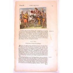
Native Americans Bring Food & Water & Treasure.
Fine Historical hand-colored copperplate engraving featuring Native Americans bringing food and treasure. Arnoldus Montanus (1625–1683) was a Dutch teacher and aut...
Date: Amsterdam. 1671
Selling price: ????
Please login to see price!
Sold in 2013
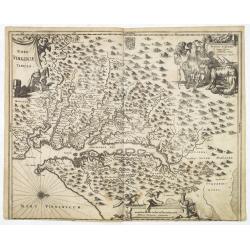
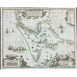
Nova Virginia Tabula.
A beautifully engraved map, derived from the highly influential map by Captain John Smith in 1612, showing Chesapeake Bay and the surrounding area.The decoration of this ...
Date: Amsterdam, 1671
Selling price: ????
Please login to see price!
Sold in 2013
Castrum Mauritij ad Ripam Fluminis S. Francisci.
Impressing copper engraving depicting Fort Maurice, which controlled the ferry on the Rio Francisco.With small letter key at the bottom.
Date: Amsterdam, 1671
Selling price: ????
Please login to see price!
Sold in 2015
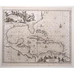
Insulae Americanae in Oceano Septentrionali, cum Terris adiacentibus.
Copper engraved map; overall size 31 x 37 cm by Arnoldus Montanus, from his: 'De Nieuwe en Onbekende Weereld: of Beschryving van America'. Montanus' derivation of Blaeu's...
Date: Amsterdam, 1671
Selling price: ????
Please login to see price!
Sold in 2017
Tabula Magellanica qua tierrae del Fuego. . .
One of the most decorative maps of the extremity of South America, with Patagonia, the Straight of Magellan, Terra del Fuego and the discoveries made by LeMaire and Schou...
Date: Amsterdam, 1671
Selling price: ????
Please login to see price!
Sold in 2016
Tabula Magellanica, qua Tierrae del Fuego, cum Celeberrimis Fretis a F. Magellano et I. Le Maire Detectis Noviss et Accuratissim Descript. Exhibetur
One of the most elaborately decorated maps focusing on the tip of South America with the Strait of Magellan and Le Maire Strait. Several strange creatures are shown in th...
Date: 1671
Selling price: ????
Please login to see price!
Sold in 2020
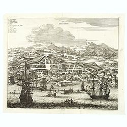
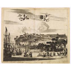
Urbs Salvador.
A handsome copper engraving of the walled city of San Salvador, with a lettered key at the top left corner.Ships and boats fill the harbor in the foreground. From Arnoldu...
Date: Amsterdam, 1671
Selling price: ????
Please login to see price!
Sold in 2017
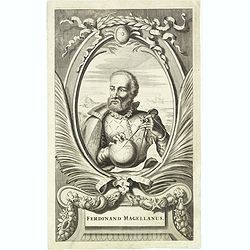
Ferdinand Magellanus.
Copper engraved portrait of Ferdinand Magellan (ca. 1480 – 1521) from Ogilby's 'America', an English edition of Montanus' 'De Nieuwe En Onbekende Weereld', published th...
Date: London, John Ogilby, 1671
Selling price: ????
Please login to see price!
Sold in 2018
The Forty Years Travels of the Children of Israel Out of Egypt. . .
A detailed map of the Palestinian and Lebanese coasts that depicts the Jews passage through the Red Sea and the Sinai Desert. North is oriented to the right. Decorated wi...
Date: London, 1671
Selling price: ????
Please login to see price!
Sold in 2023
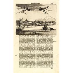
Novum Amsterodamum..
A good example of one of the earliest available views of New York, from Montanus description of America. Set in a folio page of text describing in glowing terms the attra...
Date: Amsterdam, 1671
Selling price: ????
Please login to see price!
Sold in 2011
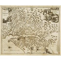
Nova Virginia Tabula.
A beautifully engraved map, derived from the highly influential map by Captain John Smith in 1612, showing Chesapeake Bay and the surrounding area. The decoration of this...
Date: Amsterdam 1671
Selling price: ????
Please login to see price!
Sold
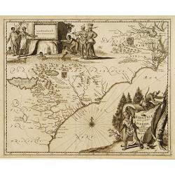
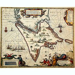
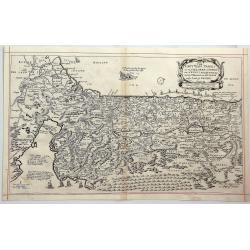
Virginiae partis australis, et Floridae partis orientalis..
A beautifully engraved map, derived from the highly influential maps by Mercator and later Blaeu. The decoration of this finely engraved map has two entirely new cartouch...
Date: Amsterdam 1671
Selling price: ????
Please login to see price!
Sold