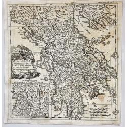
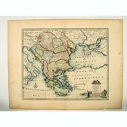
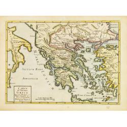
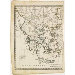
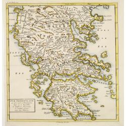
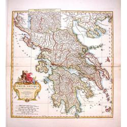
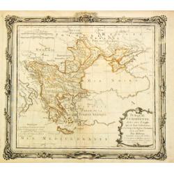
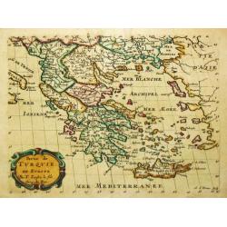
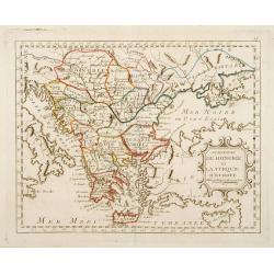
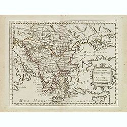
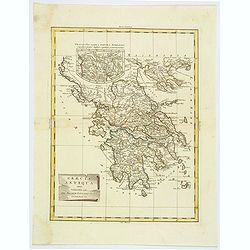
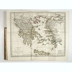
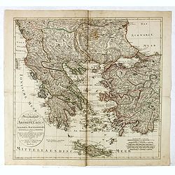
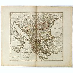
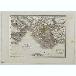
La Grecia Propriamenete Detta per la Storia Romana.
A superb map of the region of present-day Greece. The map which shows Greece under rule by the Roman Empire is well engraved with excellent detail in D'Anville's simple, ...
Date: Paris, 1742
Selling price: ????
Please login to see price!
Sold in 2021
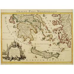
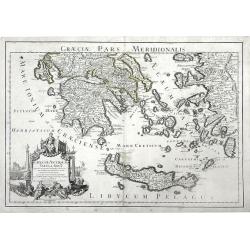
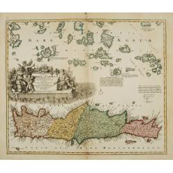
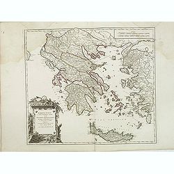
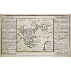
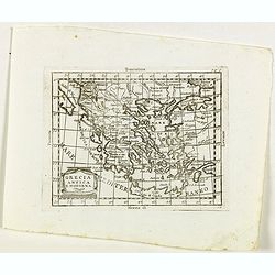
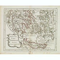
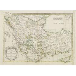
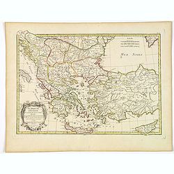
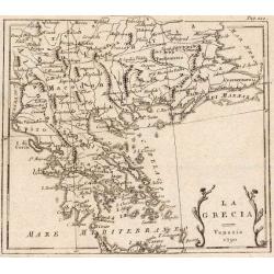
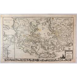
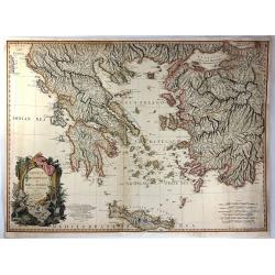
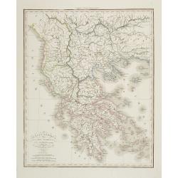
Graeciae Pars Meridionalis..
Very decorative map illustrating the southern part of Greece and a small part of Turkey. It represents the Aegean Islands and Crete as well as some islands in the Ionian ...
Date: Amsterdam c. 1745
Selling price: ????
Please login to see price!
Sold
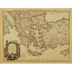
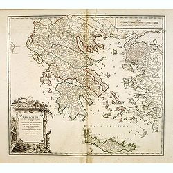
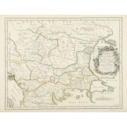
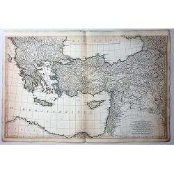
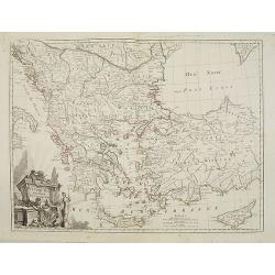
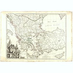
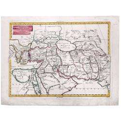
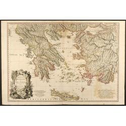
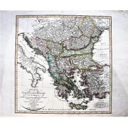
Carte de la Grece dressée sur un grand nombre de memoires..
Detailed copper-engraved map of Greece with its neighbouring countries, including southern Italy and part of Cyprus. Relief shown pictorially. With large decorative title...
Date: Amsterdam c. 1745
Selling price: ????
Please login to see price!
Sold
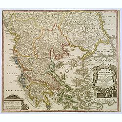
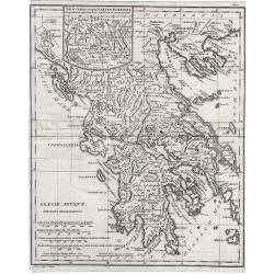
Graeciae Antiquae Tabula Nova . . .
Finely detailed map of Greece, Crete and the southeastern coast of Asia Minor based on a 1707 map by de L'Isle, and later republished by Buache in 1745. Cities, villages,...
Date: Paris, 1745
Selling price: ????
Please login to see price!
Sold in 2010
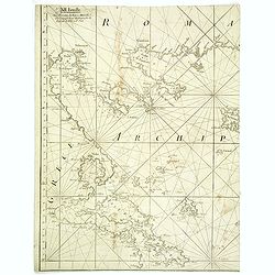
![A Chart of the South part of Cephalonia, with the Islands of Zante and the Coast of Morea ... [on sheet with] A Chart of the South Coast of Morea from Venetica to CS. Angelo](/uploads/cache/97451-250x250.jpg)
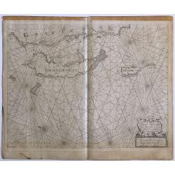
A Chart of the South part of Cephalonia, with the Islands of Zante and the Coast of Morea ... [on sheet with] A Chart of the South Coast of Morea from Venetica to CS. Angelo
This two part sea chart features the island of Zante and Cephanolia on the left side, and Serigo to Candia (Crete) on the right. Engraved by 'J[oel] Gas[coyne]' this plat...
Date: 1747
Selling price: ????
Please login to see price!
Sold in 2016
A Chart of the Islands Corfu, Pachsu and Antipachsu with ye Channel and Roads between the Island of Corfu & ye Graetian Coast
A superb rare sea chart with rhumb lines of Corfu and nearby coastlines. The main town and castle in Corfu is clearly outlined. It is engraved by 'J[oel] Gascoyne' and wa...
Date: 1747
Selling price: ????
Please login to see price!
Sold in 2016
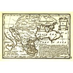
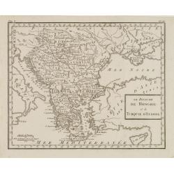
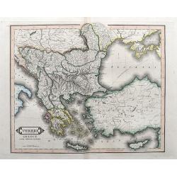
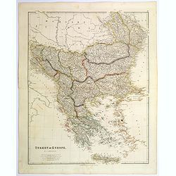
A new & accurate map of Turkey in Europe with the adjacent countries. . .
An excellent mid 18th century map of Greece, including Albania, Macedonia, Romania, Bulgaria, Serbia, Croatia, Hungary etc. the Black Sea and part of Turkey. An early imp...
Date: London, 1747
Selling price: ????
Please login to see price!
Sold in 2023
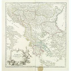
Carte de la Turquie d\'Europe des Isles de la Grece et de l\'Archipel.
Small detailed map encompassing the area between the Adriatic Sea and the Black Sea. Centered on Greece.From Atlas Portatif Universel, by Robert de Vaugondy. Page 63 and ...
Date: Paris, later than 1748
Selling price: ????
Please login to see price!
Sold in 2008
Insula Creta hodie Candia.
Johann Baptist Homann's well-engraved map has a large decorative cartouche. Detailed map of Crete.Johann Baptist Homann (1663-1724) was a German engraver and publisher, w...
Date: Nuremberg 1749
Selling price: ????
Please login to see price!
Sold
Carte de l'Ancienne Grece ..
Uncommon map of ancient Greece. For Introduction à l'Histoire Universelle du Baron de Puffendorf.
Date: Paris c.1750
Selling price: ????
Please login to see price!
Sold
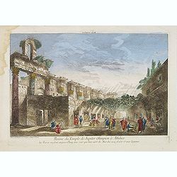
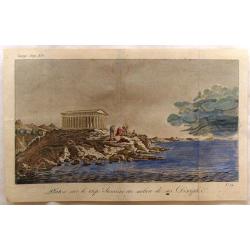
Ruine du Temple de Jupiter Olimpien à Athênes les Turcs en sont aujour d'huy une rue quil leur sert de Marché aux fruits et aux legumes.
Optical print of the ruins of the Temple of Jupiter Olympius in Athenes. This famous temple was build by Antiochus. Published by Jacques Chereau, who was a well-known pub...
Date: Paris, ca. 1750
Selling price: ????
Please login to see price!
Sold in 2016
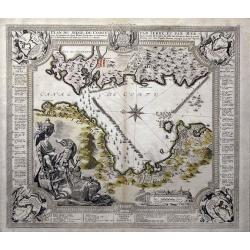
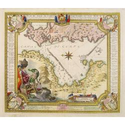
Plan du siege de Corfu par Terre et par Mer...
This uncommon map depicts the western coast of Corfu, including Kérkira at the time of the siege on July 5th, 1716 against the Turkish marine. Part the Greek coast (prov...
Date: Nuremberg, 1750
Selling price: ????
Please login to see price!
Sold in 2015
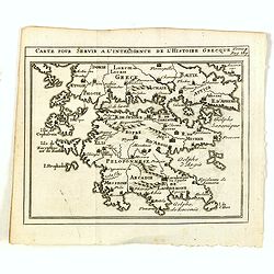
Carte pour servir a l'intelligence de l'histoire Grecque.
Scarce small map of Greece based on cartography of Guillaume Delisle. Published in "Nouveau traité de geographie par M**** ", published by La veuve Lottin &...
Date: Paris, 1752
Selling price: ????
Please login to see price!
Sold in 2020
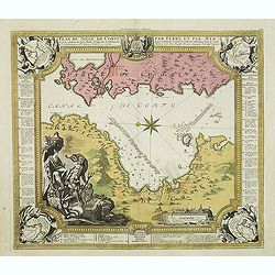
Plan du siege de Corfu par Terre et par Mer.
Uncommon map of the western coast of Corfu, including the town of Kérkira and its siege on July 5th, 1716. Upper part the coast of the Greek province of Sarande. Well-en...
Date: Nuremberg, 1753
Selling price: ????
Please login to see price!
Sold in 2010
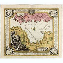
Plan du siege de Corfu par Terre et par Mer.
Uncommon map of the western coast of Corfu, including the town of Kérkira and its siege on July 5th, 1716. Upper part the coast of the Greek province of Sarande. Well-en...
Date: Nuremberg, 1753
Selling price: ????
Please login to see price!
Sold in 2013
Plan du siege de Corfu par Terre et par Mer.
Uncommon map of the western coast of Corfu, including the town of Kérkira and its siege on July 5th, 1716. Upper part the coast of the Greek province of Sarande. Well-en...
Date: Nuremberg, 1753
Selling price: ????
Please login to see price!
Sold in 2021
Neue Vorstellung der Insel Creta. . .
A rare map of the Aegean Sea and its islands. From Chalkidiki until Crete. With parts of the Greek and Turkish coats.After Anville, engraved by Reinhardt, published by th...
Date: Frankfurt & Leipzig, 1753
Selling price: ????
Please login to see price!
Sold in 2017

Plan de la place de Corfu avec ses environs. . .
Uncommon map of the town of Kérkira and its siege in 1716, on the island of Corfu. Johann Baptist Homann's well-engraved map has a large decorative cartouche and in each...
Date: Nuremberg 1753
Selling price: ????
Please login to see price!
Sold in 2023
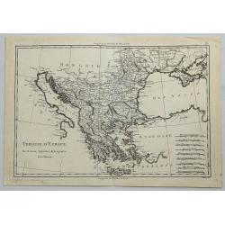
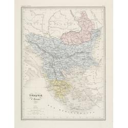
Turquie Européenne.
A beautiful map of Greece, with the coast of Turkey from De Vaugondy’s 1752 Atlas Universal. Depicts the whole of Greece from Bosnia and Croatia east to through Bulgari...
Date: Paris, 1755
Selling price: ????
Please login to see price!
Sold in 2011
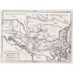
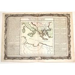
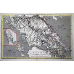
Pannonia Moesia Illyricum & Thracia.
Pannonia Moesia Illyricum & Thracia by Christoph Cellarius c1755 from his Geographia Antiqua. Highly detailed map of ancient Greece.
Date: Leipzig, 1755
Selling price: ????
Please login to see price!
Sold in 2014
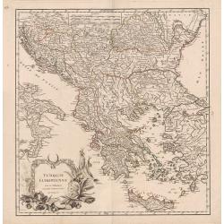
Turquie Européenne.
A beautiful map of Greece, with the coast of Turkey from De Vaugondy’s 1752 Atlas Universal. Depicts the whole of Greece from Bosnia and Croatia east to through Bulgari...
Date: Paris, 1755
Selling price: ????
Please login to see price!
Sold in 2013
La Grece.
Fine map of Greece. George Louis Le Rouge was active from 1740- till 1780 as a publisher, and was appointed engineer for the King of France. From his Atlas Nouveau Portat...
Date: Paris 1756
Selling price: ????
Please login to see price!
Sold
Oud Griekenland zo als 't eerste in Koninkrijken..
Very unusual map of ancient Greece. In upper left margin V. Deel Bladz.275.
Date: Utrecht c.1757
Selling price: ????
Please login to see price!
Sold
Graecia Vetus ex schardis Sansonianis desumpta. . .
Decorative map of ancient Greece and neighboring Islands in the Ionian and Aegean Seas, with a large decorative cartouche. Also shows a fair amount of Turkish Asia, along...
Date: Paris, 1757
Selling price: ????
Please login to see price!
Sold in 2012
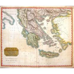
Graecia Nova et Mare Aegeum l'Archipelagus .. Morea..
An attractive map of Greece, with a beautiful title cartouche, and an explanation table and mileage scales filling the lower corners of the map.T.C. Lotter married M. Seu...
Date: Augsburg, 1760
Selling price: ????
Please login to see price!
Sold in 2017
![[Lot of 6 maps of Italy]](/uploads/cache/20941-(1)-250x250.jpg)
[Lot of 6 maps of Italy]
Claude Buy de Mornas (dl 1783), géographe du roi (1764). Atlas Méthodique et Elémentaire de Géographie et d' Histoire, 1761, Atlas Historique et Géographique, 1762.�...
Date: c. 1760
Selling price: ????
Please login to see price!
Sold in 2022
Graeciae Antiquae Specimen Geographicum.
Decorative map of Ancient Greece, with a large, decorative, Rococo, title cartouche. With an inset depicting northern Greece. Jean Baptiste d'Anville (1697-1782) born in...
Date: Paris, 1762
Selling price: ????
Please login to see price!
Sold in 2013
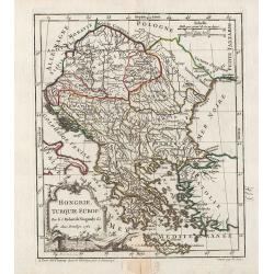
Hongrie, Turquie Europ?
General map of Greece. From Gilles Robert de Vaugondy's Nouvel Atlas Portatif.
Date: Paris, 1762
Selling price: ????
Please login to see price!
Sold in 2011
Suite de L'Histore d'Athens Depuis L'An 3573 Jusqu'a L'An 3581.
Striking map of ancient Athens featuring the territory including current Italy and Greece, north of the Mediterranean Sea. The text in the sides of the map describe the h...
Date: Paris, 1762
Selling price: ????
Please login to see price!
Sold in 2015
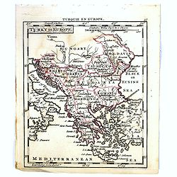
Turky in Europe.
Uncommon miniature map of Greece with the western most coast of Turkey, engraved by Thomas Kitching for "A New General and Universal Atlas Containing Forty five Maps...
Date: London, 1761-1763
Selling price: ????
Please login to see price!
Sold in 2017
![I. Metelin. [53]](/uploads/cache/12273-250x250.jpg)
I. Metelin. [53]
Charming chart of the island of Metelin. Showing town and harbour plans, with soundings, anchorages, rocks, shoals, fortifications, lighthouses.Joseph Roux (1725-1793) wa...
Date: Marseille, 1764
Selling price: ????
Please login to see price!
Sold in 2018
![Plan de la Ville de Candie. [Iráklion]](/uploads/cache/25918-250x250.jpg)
Plan de la Ville de Candie. [Iráklion]
This chart shows the harbour of Iráklion. In lower part a key A-V, 1-12 to the bastions and gates of the town.From Bellin's Petit atlas maritime.Tome IV N119.Jacques Nic...
Date: Paris, 1764
Selling price: ????
Please login to see price!
Sold in 2023
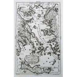
XII Feuille. (Chart of northern part of Greece with Thessaloniki)
Detail of a larger chart of Northern part of Greece, prepared by Bellin and published by J. Roux. The left half of chart XII from Joseph Roux's Carte de La Mer Meriterane...
Date: Marseille, 1764
Selling price: ????
Please login to see price!
Sold in 2013
Turquie Europeenne.
Louis Brion de la Tour (1756-1823), ' Atlas Géneral, Civil et Ecclésiastique', 1766, ' Atlas Général', 1790-98. Louis Charles Desnos (fl.1750-70), Le Rouge's 'Atlas N...
Date: Paris, 1766
Selling price: ????
Please login to see price!
Sold in 2017
Turquie Européenne avec les états qui en sont tributaires.
Louis Brion de la Tour (1756-1823), ' Atlas Géneral, Civil et Ecclésiastique', 1766, ' Atlas Général', 1790-98. Louis Charles Desnos (fl.1750-70), Le Rouge's 'Atlas N...
Date: Paris, 1769
Selling price: ????
Please login to see price!
Sold
Carte de la Grece dressée sur un grand nombre de memoires..
Detailed copper-engraved map of Greece with its neighboring countries, including southern Italy and part of Cyprus. Relief shown pictorially. With large decorative title ...
Date: Paris, 1780
Selling price: ????
Please login to see price!
Sold in 2009
Partie de Turquie en Europe.
Nicolas Sanson (1600-67), ' father of the French cartography' and founder of the Sanson firm. Atlas ' Cartes générales de toutes les parties du Monde', 1658-70 and a po...
Date: Paris, c. 1780
Selling price: ????
Please login to see price!
Sold
Bottom Part Only of Huge Map centering on Greece.
A large bottom portion of a huge map centering on Greece. The original map was about 41" x 32".This section covers the area between Libya and Iraq on the south ...
Date: Anon, ca. 1780
Selling price: ????
Please login to see price!
Sold in 2017
Grecia Antica e Moderna.
Rare map of Greece, from "Atlante Novissimo ad uso Dei Giovani Studiosi Contenuto In Carte XXVII.", published by Giovanni Zempel in Rome, ca. 1780.The map is ba...
Date: Rome, 1780
Selling price: ????
Please login to see price!
Sold in 2020
Graeciae pars meridionalis auctore. . .
Rare map of Greece and the most western coastline of Turkey, prepared by Nolin and published by L.J. Mondhare for his Atlas Général a l'usage des colleges et maisons d'...
Date: Paris, 1781
Selling price: ????
Please login to see price!
Sold in 2017
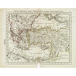
Orbis Romani Pars Orientalis. . .
Unusual map of Ancient Turkey, including a curiously shaped Cyprus, prepared by Nolin and published by L.J. Mondhare for his Atlas Général a l'usage des colleges et mai...
Date: Paris, 1781
Selling price: ????
Please login to see price!
Sold in 2023
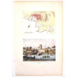
Plan de la ville et des Ports de Rhodes & Vue du Port des Bateaux a Rhodes.
Two detailed steel engraved prints of Rhodes on one sheet. Features an overhead view of the fortification as well as a view of the ships at port. ByCompte de Choiseul-G...
Date: Paris, 1782
Selling price: ????
Please login to see price!
Sold in 2013
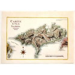
Carte de L\'Ile de Samos.
Fine copper engraved, hand-colored map of the Island of Samos in the Greek Islands. Marie-Gabriel-Florent-Auguste de Choiseul-Gouffier (1752-1817) was a member of the A...
Date: Paris, 1782
Selling price: ????
Please login to see price!
Sold in 2014
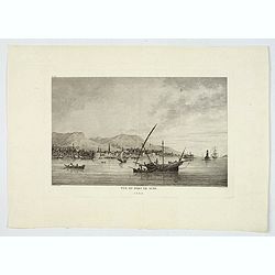
Vue du Port de Scio.
A delightful copperplate view of the port of the Greek island of Chios. It shows fishermen on their boats in the foreground, and the town and surrounding hills in the bac...
Date: Paris, 1782
Selling price: ????
Please login to see price!
Sold in 2019
Le Royaume de Hongrie et la Turquie d'Europe ..
Rare map of Greece and Hungary prepared by J.B.Nolin and published by Monhare for his Atlas Général a l'usage des colleges et maisons d'education.. Louis Joseph Mondhar...
Date: Paris, 1783
Selling price: ????
Please login to see price!
Sold
Turquie d'Europe et partie de celle d'Asie..
Attractive map centered on the Aegean Sea, encompassing the whole Balkan Peninsula and part of Turkey.It includes also Crete and Cyprus. Decorated with a decorative title...
Date: Paris, ca 1783
Selling price: ????
Please login to see price!
Sold in 2011
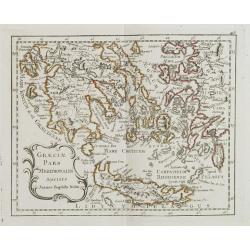
Graeciae Pars Meridionalis. . .
Rare map of Greece prepared by J.B.Nolin and published by Monhare for his Atlas Général a l'usage des colleges et maisons d'education.. Louis Joseph Mondhare was active...
Date: Paris, 1783
Selling price: ????
Please login to see price!
Sold in 2008
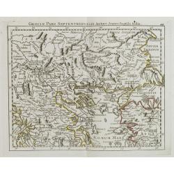
Graeciae Pars Septentrionalis?
Rare map of northern part of Greece, prepared by J.B.Nolin and published by Monhare for his Atlas Général a l'usage des colleges et maisons d'education.. Louis Joseph M...
Date: Paris, 1783
Selling price: ????
Please login to see price!
Sold in 2008
Le Royaume de Hongrie et la Turquie d'Europe. . .
Scarce map of Greece, Romania, Bulgaria and Hungary prepared by Nolin and published by L.J. Mondhare for his Atlas Général a l'usage des colleges et maisons d'education...
Date: Paris, 1783
Selling price: ????
Please login to see price!
Sold in 2017
Turquie d'Europe et partie de celle d'Asie divisee. . .
An attractive map centered on the Aegean Sea, encompassing the whole Balkan Peninsula and part of Turkey.It includes also Crete and Cyprus. Decorated with a pretty title ...
Date: Paris, ca 1783
Selling price: ????
Please login to see price!
Sold in 2021
Turquie d'Europe..
Detailed map encompassing present day Greece and part of Turkey. In the lower right corner a large depiction of Cyprus. Venetian edition of the map by Bellin, to whom San...
Date: Venice, 1776 - 1784
Selling price: ????
Please login to see price!
Sold in 2008
Turquie d'Europe..
Detailed map encompassing present day Greece and part of Turkey. In the lower right corner a large depiction of Cyprus. With ornamental title cartouche and noteworthy top...
Date: Venice, 1776 - 1784
Selling price: ????
Please login to see price!
Sold in 2018
Graecia Antiqua.
A detailed map of Ancient Greece and contiguous Islands and countries. Issued as part of Zatta's Atlante Novissimo. Inset of northern Greece. Pretty title cartouche.
Date: Venice, 1785
Selling price: ????
Please login to see price!
Sold in 2019
ALEXANDER THE GREAT, Imperium ALEXANDRI MAGNI Per Europam, Asiam, et Africam.
A detailed map of the Empire of Alexander the Great, extending from Asia Minor and Greece to the regions around the Black Sea and Capian Sea, reaching the Indus River in ...
Date: Venice, 1785
Selling price: ????
Please login to see price!
Sold in 2022
Turquie D'Europe.
A fine, detailed, antique map of Greece, by Bonne, published in the 1787 “Atlas Encyclopedique”.Rigobert Bonne (1727–1794) was one of the most important cartographe...
Date: Paris, 1787
Selling price: ????
Please login to see price!
Sold in 2018
La Turchia d. Europa.
A small map depicting Greece and the Balkan, from the Italian edition of Claude Buffier's ' Geographie Universelle'.
Date: Venice, 1790
Selling price: ????
Please login to see price!
Sold
Recueil de Cartes Geographiques, Plans, Vues et Medailles de L'Ancienne Grece, Relatifs Au Voyage du Jeune Anacharsis, Precede d'une Analyse Critique des Cartes.
Great atlas of Ancient Greece, including many classical maps and battle plans. 31 copper engraved maps plans and plates with several hand colored in outline, many double ...
Date: Paris, 1790
Selling price: ????
Please login to see price!
Sold in 2017
A Correct Map of Ancient Greece.
A striking, highly detailed copper engraved map of Greece in ancient times. The map provides good topographic details. An inset map of north-eastern Sicily, Italy, adorns...
Date: London, 1790
Selling price: ????
Please login to see price!
Sold in 2019
Greece. Archipelago and Part of Anadoli. By L.S. de la Rochette. MDCCXC. London, Published for Willm. Faden, Geographer to the King. January 1st. 1791
Large Folio engraved map of Greece and Western part of Turkey from W. Faden, engraved by William Palmer. Showing the Peloponnese, Central Greece, southern part of Albania...
Date: London, 1791
Selling price: ????
Please login to see price!
Sold in 2009
Platon Sur le Cap Sunium au Milieu de ses Disciples.
View of the Temple of Poseidon with Plato and Disciples by Bocage. Prepared in 1791 to illustrate the travels of Anacharis.
Date: Paris, 1791
Selling price: ????
Please login to see price!
Sold in 2019
Greece, Archipelago and Part of Anadoli by L.S. De La Rochette
A large folio engraved map of Greece and part of Turkey. Engraved by William Palmer. Showing the Peloponnese, Central Greece, southern part of Albania, Constantinople in ...
Date: London, 1791
Selling price: ????
Please login to see price!
Sold in 2016
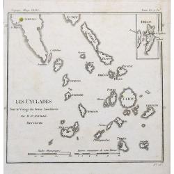
Les Cyclades. . .
A map of Greek islands called the Cyclades in the Aegean Sea. The map extends from Athens to Anafe. Including Andros, Mikonos, Naxos, Ios, Milos, Santorini. An inset map ...
Date: Paris, 1791
Selling price: ????
Please login to see price!
Sold in 2019
Turky in Europe.
Uncommon miniature map from Gibson's "Atlas Minimus, or a New Set of Pocket Maps of the several Empires, Kingdoms and States of the known World".
Date: London, 1792
Selling price: ????
Please login to see price!
Sold in 2011
Graeciae Antiquae.
Graeciae Antiquae 1795 by Samuel John Neele. Published May 10th 1795 by Cadell & Davies of the Strand London.Highly detailed small map.
Date: London, 1795
Selling price: ????
Please login to see price!
Sold in 2012
Griechenland, der Archipelagus, Albanien, Macedonien, Romanien und ein Theil von Anadoli: nach De la Rochette, Le Clerc etc ... Schneider & Weigel, 1796.
Nice map of Greece, Albania, Macedonia and Romania by Weigel.
Date: Augsburg, 1796
Selling price: ????
Please login to see price!
Sold in 2019
Charte vom Türkischen Reiche in Europa / nach den neuesten astronomischen Ortsbestimmungen entworfen. . .
A large, decorative map of central and south Europa showing the possessions of the Ottoman Empire in Europe in the year 1800.
Date: Weimar, 1800
Selling price: ????
Please login to see price!
Sold in 2019
Le Royaume de Hongrie et la Turquie d'Europe.
Map of south eastern Europe centered on Greece and the Aegean Sea. From Atlas de la Géographie de toutes les parties du monde .. Ouvrage destiné pour l'education, et n�...
Date: Paris, Prudhomme, Levrault, Debray, 1806
Selling price: ????
Please login to see price!
Sold in 2020
Hellas sive Graecia propria Thessalia et Epirus...
Interesting map showing a part of Greece during ancient times, extending from Kefalonia and Zakynthos (Zante) Island to Nisos Evvoia. Includes Korfu, parts of Macedonia, ...
Date: London, 1807
Selling price: ????
Please login to see price!
Sold in 2012
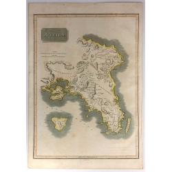
Attica.
This is an attractive 1814 John Thomson map of Attica, Greece. The map features many of the important cities and sites in early Greek History. It shows Athens, the Plain ...
Date: Edinburgh, 1815
Selling price: ????
Please login to see price!
Sold in 2017
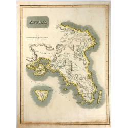
Attica.
An attractive map of Attica, in Greece. It features many of the important cities from early Greek History including: Athens, the Plain of Marathon, Salamis, and the islan...
Date: Edinburgh, 1816
Selling price: ????
Please login to see price!
Sold in 2016
General Charte von der Europaischem Türkey
Nice map of Greece, Albania, etc by Johannes Walch.Johann Walch (1757-1824) was cartographer and map publisher active in Augsburg, he was the son-in-law of Johann Martin ...
Date: Augsburg, 1820
Selling price: ????
Please login to see price!
Sold in 2019
South Part of Turkey in Europe.
A map of Greece, showing Crete, Albania and Turkey. It was drawn & engraved for Thomson's "NEW GENERAL ATLAS" in Edinburgh in 1821.
Date: Edinburgh, 1821
Selling price: ????
Please login to see price!
Sold in 2016
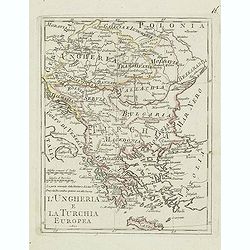
L'ungheria e la turchia Europea. . .
Charming map of Hungary, Macedonia, Bulgaria and Greece from the rare atlas Atlante Tascabile o sia Serie di Num. XXI Cartine Geografiche nelle quali si rappresenta in ri...
Date: Rome, 1823
Selling price: ????
Please login to see price!
Sold in 2011
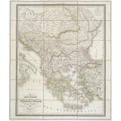
Carte Générale de la Turquie d'Europe et de la Grèce. . .
Map of Greece, including the regions of Romania, Bulgaria, Bosnia, Servia and part of the Black Sea with the western part of Turkey including Constantinople. Published a...
Date: Paris, 1827
Selling price: ????
Please login to see price!
Sold in 2011
Grecia Antiqua . . .
Detailed map of Ancient Greece, prepared by A. H. Basset, rue Saint-Jacques, no. 64, Paris and published in Atlas classique et Universel de Géographie . . . .The engrave...
Date: Paris, A.H. Basset, 1828
Selling price: ????
Please login to see price!
Sold in 2022
Turkey in Europe, Greece & the Ionian Islands.
A scarce and a highly detailed map of Turkey and Greece. Includes the Balkans, Cyprus, Crimea and the Black Sea. An attractive example.
Date: Edinburgh, ca 1835
Selling price: ????
Please login to see price!
Sold in 2020
Turquie d' Europe. (Greece)
Detailed map of Greece.From Malte-Brun's Atlas Géographie Universelle.. ., revised by Jean Jacques Nicolas Huot.This very fine executed map has been printed by Fosset an...
Date: Paris, 1837
Selling price: ????
Please login to see price!
Sold in 2013
Turkey in Europe.
A large steel engraved map of Turkey in Europe, stretching from Croatia and Bosnia in the west across to the countries bordering the Black sea, southwards through mainlan...
Date: London, 1839
Selling price: ????
Please login to see price!
Sold in 2020
La Grèce et ses colonies.
Detailed map of Greece, prepared by Charles V. Monin (fl.1830-1880) a French cartographer of Caen and Paris. Published in Atlas Universel de Géographie Ancienne &c M...
Date: Paris, 1845
Selling price: ????
Please login to see price!
Sold in 2020
