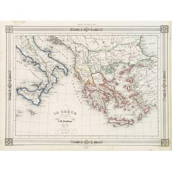
La Gréce et ses colonies.
Decorative map of Greece after A.H.Dufour, prepared by J.G.Barbié du Bocage.Engraved by Ch.Smith, published by Basset who was established in Paris, rue de Seine 33. From...
Date: Paris 1846
Selling price: ????
Please login to see price!
Sold
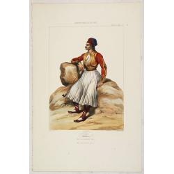
PALICAR. (Iles de l'archipel grec). Costumes Syriens 8.
A beautiful hand colored lithograph of a Palicar published in the French work "Galerie Royale de Costumes peints d´après nature par divers artistes et lithographi�...
Date: Paris, Chez Aubert & Cie., 1842-1848
Selling price: ????
Please login to see price!
Sold in 2017
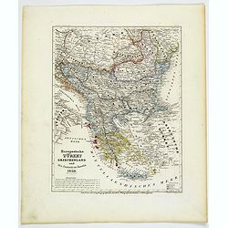
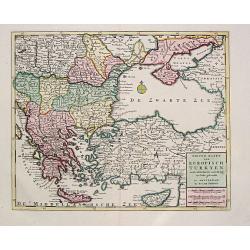
Europaeische Turkey, Griechenland und die Ionischen Inseln.
A steel-engraved outline hand color map Turkey in Europe, color-coded by region, with an explanation box lower right corner. An interesting historical map showing the reg...
Date: Hildburghausen, 1850
Selling price: ????
Please login to see price!
Sold in 2021
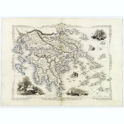
Ionian Islands and Greece.
This is John Tallis’ pretty map of the Ionian Islands and Greece. The map is surrounded by a five delicate steel engraved vignettes, and the whole is surrounded by a de...
Date: London, 1851
Selling price: ????
Please login to see price!
Sold in 2018
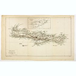
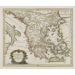
Creta Insula sec. Stadiasmum Maris Magni.
Delicate map of ancient Crete, according to the "Stadiasmus Maris Magni", prepared by Karl Wilhelm Ludwig Muller (1813-1894) and published in "Geographi Gr...
Date: Paris, Ambrosio Firmin Didot, 1855
Selling price: ????
Please login to see price!
Sold in 2017
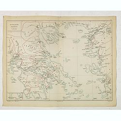
Scylacis Periplus. . .
Delicate map of ancient Greece and the West coast of Turkey according to the "Stadiasmus Maris Magni", prepared by Karl Wilhelm Ludwig Muller (1813-1894) and pu...
Date: Paris, Ambrosio Firmin Didot, 1855
Selling price: ????
Please login to see price!
Sold in 2017
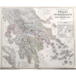
Das Königreich Hellas oder Griechenland und die Republik der sieben Ionischen Inseln (Ephtánisos).
Large and highly detailed map extending from Corfu to Santorini. With Peloponnese, Euboia, Mykonos, Kythira, Zakynthos, and many others. Includes two inset maps of Athens...
Date: Weimar, 1858
Selling price: ????
Please login to see price!
Sold in 2017
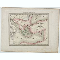
Bacino del Mediterraneo ( Parte orientale) . . .
Uncommon map with the Mediterranean Sea, centered on Greece. With a key to tracks of different streamline routes, prepared by Francesco Costantino Marmocchi. Above the ma...
Date: Genova, Paolo Rivara fu Giacomo, 1858
Selling price: ????
Please login to see price!
Sold in 2021
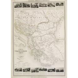
Nouvelle carte Illustrée Turquie d'Europe et de la Grèce . . .
A most decorative mid 19th century map, in upper and lower part 12 vignettes giving a wealth of statistic and commercial information. With a color key . Beside Greeve the...
Date: Paris, Fatout, 1860
Selling price: ????
Please login to see price!
Sold in 2010
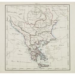
Turquie d'Europe.
Map of Greece, including Serbia, Bulgaria, Albania, Bosnia.
Date: France, ca. 1860
Selling price: ????
Please login to see price!
Sold in 2015
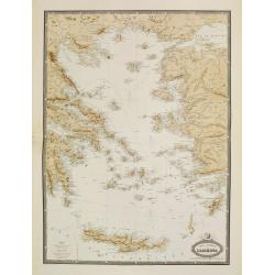
Carte Generale de L'Archipel.
Very detailed map from Atlas Sphéroïdal & Universel de géographie. Prepared by F.A.Garnier and edited by Jules Renouard, rue de Tournon, Paris. Uncommon map with d...
Date: Paris, 1861
Selling price: ????
Please login to see price!
Sold in 2022
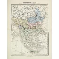
Pèninsule des Balkans.
Decorative map of the Balkan from Géographie Universelle, Atlas Migeon. published by J. Migeon. From one of the last decorative atlases published in the 19th century.
Date: Paris, 1874
Selling price: ????
Please login to see price!
Sold in 2017

Caligula's Palace and Bridge.
Fine hand-colored steel engraving by E. Goodall from a painting by the renowned J.M.W. Turner. It was published in 1875 by Appleton in New York. The engraving features &...
Date: New York, 1875
Selling price: ????
Please login to see price!
Sold in 2015
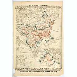
Map of Turkey in Europe. Illustrating the Berlin CongressTtreaty, July 1878.
An unusual map of Turkey, Greece, the Balkans, Austria and a part of the Ukraine, illustrating the nations created under the Berlin Congress Treaty, as well as the lands ...
Date: Philadelphia, 1878
Selling price: ????
Please login to see price!
Sold in 2021
![[Greece].](/uploads/cache/46170-250x250.jpg)
[Greece].
A detailed map of Greece published by the very successful St. Petersburg publisher "Cartographic institution A.Ilina".Alexey Afinogenovich Ilyin was a lieutenan...
Date: St. Petersburg, 1899
Selling price: ????
Please login to see price!
Sold in 2020
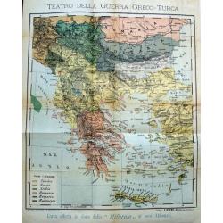
Teatro della guerra Greco-Turca.
Unusual map of South-East Europe with Greece, Romania, Bulgaria, and parts of Turkey. Coloring indicates the countries during the The Greco-Turkish War of 1919–1922. Pu...
Date: Milan, c. 1925
Selling price: ????
Please login to see price!
Sold in 2017
Rodi. Rhodes. Rhodos
Pictorial map of Rhodes, the island of the sun or rose island in Greece. Signed by Egon Huber Rodi 1935 on lower right. On upper right: Rodi, Rhodes, Rhodos, Rhodus. Show...
Date: Italty, 1935
Selling price: ????
Please login to see price!
Sold in 2021
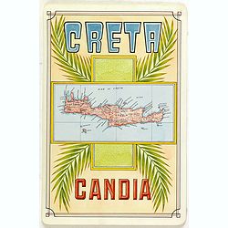
Creta Candia
Unique manuscript map of Crete. Award-winning manuscript card, prepared by Antonio Raggio for the 11th Congreso de la Union Postal Universal (World Postal Congress) Expos...
Date: Buenos Aires, 1939
Selling price: ????
Please login to see price!
Sold in 2023
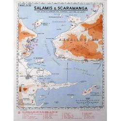
Salamis & Scaramanga.
A "Secret" map was printed by the South African Survey Co, in December 1941, after the German invasion of Greece. Shows a portion of the Saronic Gulf with the S...
Date: South Africa, 1941
Selling price: ????
Please login to see price!
Sold in 2016
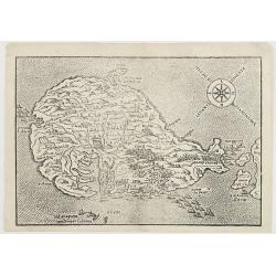
Mandria, Fornoli, Lipso and Cruscia /.(verso) Lango.
Benedetto Bordone (1460-1531), cartographer and engraver. Published in 1528 his islands book, 'Isolario'.Two woodcut maps from Bernadetto Bordone?s ?Isolario?.
Date: Venice, 1532.
Selling price: ????
Please login to see price!
Sold
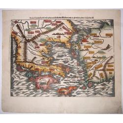
Neuw Griechenlandt, mit andern. . .
A nice full color example of Münster's first map of modern Greece, from Munster's 'Cosmographia', one of the most influential geographical works of the 16th century. Dat...
Date: Basel, ca 1550
Selling price: ????
Please login to see price!
Sold in 2020
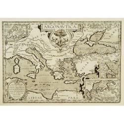
Argonautica.
A very nice map of Greece. Very decorative title cartouche centred in the upper part of the map. Three inset maps in upper left-hand corner and lower-right-hand corner, i...
Date: Antwerp 1603-1618.
Selling price: ????
Please login to see price!
Sold
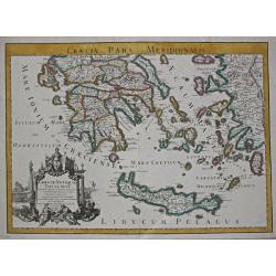
Graecia Antiquae Tabula Nova / Pars Meridionalis.
Guillaume de l' Isle (1675-1724), Royal Geographer, was the most influential cartographer of the first quarter of the 18th century. ' Atlas de Géographie' (1700-12), pos...
Date: Paris, 1707.
Selling price: ????
Please login to see price!
Sold
Nieuwe Kaart van Europisch Turkyen.
Izaak Tirion (d.1769) Amsterdam publisher. His Nieuwe en beknopte handatlas saw 6 editions between before 1740 and after 1784. Also Tegenwoordige staat van alle volkeren,...
Date: Amsterdam, 1733.
Selling price: ????
Please login to see price!
Sold
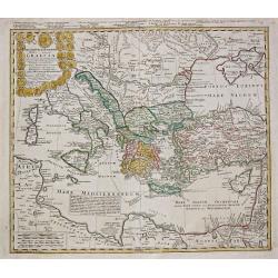
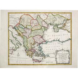
Imperii Turcici Europaei Tera in primis Graeciae.
Homann Heirs (of Johann Baptist and Johann Christof) published: Grosser Atlas, 1731, 1737. Geogr. Maior, 1759, Atlas Homannianus, 1762. A map showing the eastern Mediterr...
Date: Nurnberg, 1741.
Selling price: ????
Please login to see price!
Sold
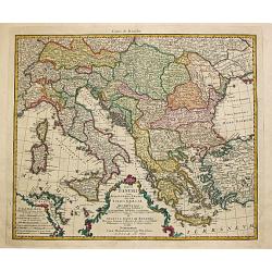
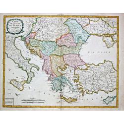
Totius Danubii cum Adjacentibus Regnis nec non totius Graciae et Archipelagi.
Homann Heirs (of Johann Baptist and Johann Christof) published: Grosser Atlas, 1731, 1737. Geogr. Maior, 1759, Atlas Homannianus, 1762.A map depicting southeast Europe wi...
Date: Nurnberg, 1766.
Selling price: ????
Please login to see price!
Sold
Nieuwe en Naauwkeurige Kaart / van / EUROPEËSCH TURKYE / benevens de aangrenzende Landen / Hongaryen, Zevenbergen, / Klein Tartarye enz.
Willem Albert Bachiene (1712-1783), Dutch geographer in Maastricht. Most important work ' Heilige Geographie', a work on the Holy Land. Mathijs Schalenkamp published in 1...
Date: Amsterdam, 1785.
Selling price: ????
Please login to see price!
Sold
Carte de l' Empire de Turquie en Europe.
Pierre Bourgoin, Paris-based engraver and publisher. Published in 1784 his uncommon ' Atlas Élémentaire de la Géographie'. After his death his widow continued the busi...
Date: Paris, 1788.
Selling price: ????
Please login to see price!
Sold
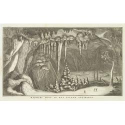
Marmere grot op het eiland Antiparos.
Marble Cave of Antiparos, who is an island in the island group Cyclades in the Aegean Sea, in the modern eparchy of Naxos. The cave itself, which is about 150 feet by 100...
Date: Amsterdam, c.17
Selling price: ????
Please login to see price!
Sold in 2014
GREECE.
Map of Greece. Macedonia, western coast of Turkey and part of Italy. Cartouche in the left hand bottom with titles. From the book "History of the Jews" by Humph...
Date: The netherlands 18th. century.
Selling price: ????
Please login to see price!
Sold in 2008
