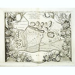
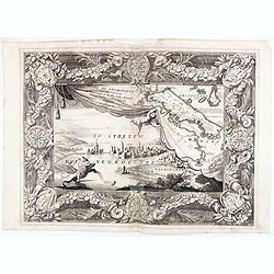
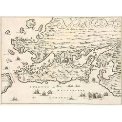
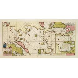
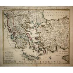
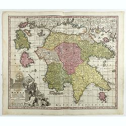
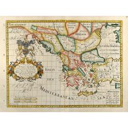
Conquiste della Serenissima Republica di Venetia nella Morea sotto il comando del Doge Francesco Morosini. . .
Curious and decorative map centered on Korinthos on the Peloponnese, covering the region of now-a-days Korinthos and the Corinth Canal. The map is bordered with medallion...
Date: Venice, 1692
Selling price: ????
Please login to see price!
Sold in 2012
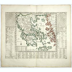
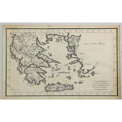
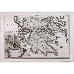
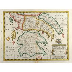
La Moree et les Isles de Zante, Cefalonie, Ste Maure, Cerigo.
A large wall size map of Morea, the Southern part of Greece. Printed from two plates, and con-joined. Twelve small city maps and fortification plans surround the title ca...
Date: Paris, 1692
Selling price: ????
Please login to see price!
Sold in 2016
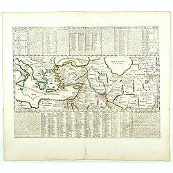
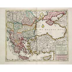
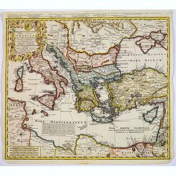
Estats / de l' Empire de Turcs / en Europe.
Alexis-Hubert Jaillot (1632-1712), French cartographer. He joined the Sanson heirs and redrew Nicolas Sanson's maps on a larger scale. 'Atlas Nouveau' (1674), sea-atlas '...
Date: Amsterdam, 1696
Selling price: ????
Please login to see price!
Sold
![Pianta della Forterra d'ATENE. . . [Athens]](/uploads/cache/31821-250x250.jpg)
Pianta della Forterra d'ATENE. . . [Athens]
A scarce town-plan showing the fortress and city of Athens, mainly concentrating on classical sites within the city, with a very fine separately printed border consisting...
Date: Venice, 1696
Selling price: ????
Please login to see price!
Sold in 2012
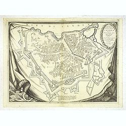
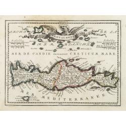
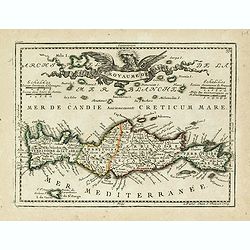
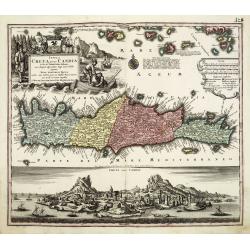
Isola e Regno di Candia. . .
A scarce and very attractive detailed two sheet map of Crete within wide garland of vines incorporating the names of 100 Cretan towns, coat-of-arms of Cardinal d' Estrée...
Date: Venice, 1696
Selling price: ????
Please login to see price!
Sold in 2012
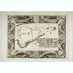
Pianta Della Real Fortezza e Citta di Candia. . .
City of Candia showing its fortifications. A beautifully ornate map with a rich, dark impression and a decorative border depicted as a hanging tapestry.The remarkable Vin...
Date: Venice, 1696
Selling price: ????
Please login to see price!
Sold
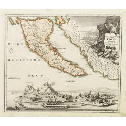
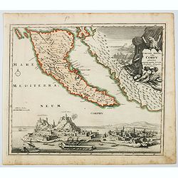
Isola di Corfu.
One of the most attractive maps of the island of Corfu ever produced. The central map is surrounded by nine plans and views of fortified locations and the ancient city of...
Date: Venice, 1696
Selling price: ????
Please login to see price!
Sold in 2014
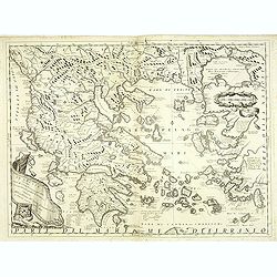
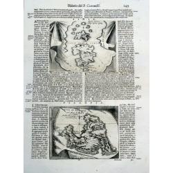
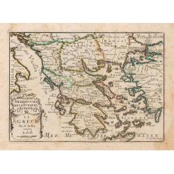
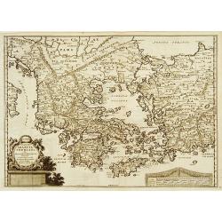
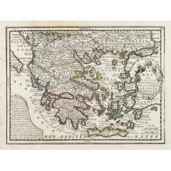
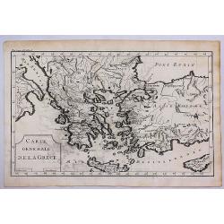
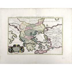
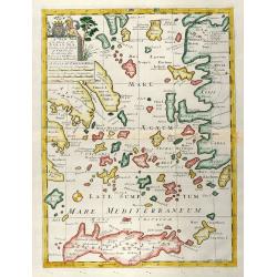
La Grecia descritta dal P. M. Coronelli Cosmografo della Serenissima Repubblica si Venezia dedicata all'Eccellenza del Signor Giovanni Lando.
Map of Greece and its islands in the Aegean and Adriatic Seas. The remarkable Vincenzo Coronelli (1650-1718), encyclopaedist, geographer, inventor and Doctor of Theology,...
Date: Venice, 1696
Selling price: ????
Please login to see price!
Sold in 2012
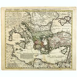
Paralello geo grafico dell'antico col moderno Arcipelago
A beautiful and rare map showing the Marmara Sea or Sea of Marmora (ancient Propontis), inland sea, north-western Turkey, connected to the Black Sea by the Bosporus Strai...
Date: Venice, 1696
Selling price: ????
Please login to see price!
Sold in 2012
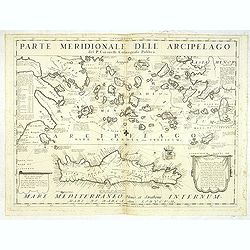
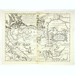
Parte Meridionale deli Archipelago. . .
A scarce and very attractive detailed map of Crete and the Aegean Sea. Forming a set with lot 31826The remarkable Vincenzo Coronelli (1650-1718), encyclopaedist, geograph...
Date: Venice, 1696
Selling price: ????
Please login to see price!
Sold in 2012
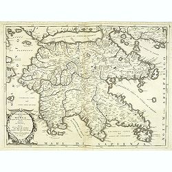
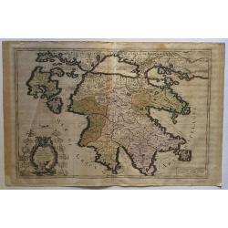
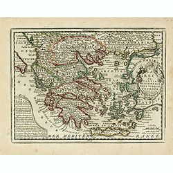
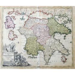
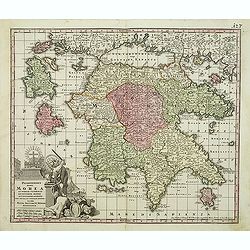
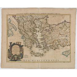
Peloponneso hoggidi Morea. . .
Decorative and highly detailed map of Morea, southern Greece with title cartouche lower left.The remarkable Vincenzo Coronelli (1650-1718), encyclopaedist, geographer, in...
Date: Venice, 1696
Selling price: ????
Please login to see price!
Sold in 2013
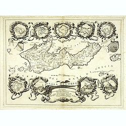
Isola di S. Maura.
A scarce and very attractive detailed map of S. Maura, with a dedication to Matteo Sanudo. With inset map. The remarkable Vincenzo Coronelli (1650-1718), encyclopaedist, ...
Date: Venice, 1696
Selling price: ????
Please login to see price!
Sold
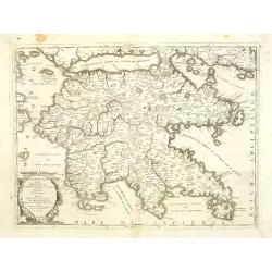
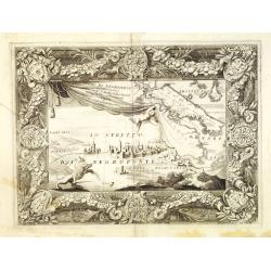
Peloponneso, hoggidi Morea,. . .
A beautiful and flamboyantly engraved large-scale map of Morea, who was in 1683 invaded by the Venetians. The map carries a dedication to Marcello Sacchetti, ambassador f...
Date: Venice, ca. 1696
Selling price: ????
Please login to see price!
Sold
Simie, Piscopia, Nisari.
Three maps of Symi, Telos and probably Nisiros in the south Aegean Sea. Large sheet with the three maps and lengthy Italian text about the islands. From Coronelli's famou...
Date: Venice, 1696
Selling price: ????
Please login to see price!
Sold in 2015
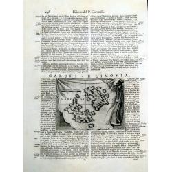
Carchi e Limonia.
Early map of the islands of Halki and Alimia near Rhodes. The map is set on a sheet with italian text, printed on both sides.
Date: Venice, 1696
Selling price: ????
Please login to see price!
Sold in 2015
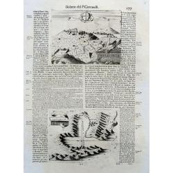
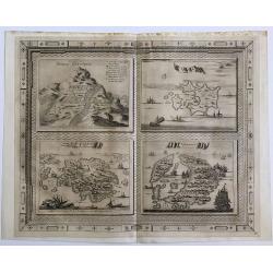
Kefalonia.
Three maps/views of Kefalonia, the largest of the Ionian islands. Includes a view of a hillside town labeled 'Cefalonia', map of the harbor of 'Argostoli', and a plan of ...
Date: Venice, 1696
Selling price: ????
Please login to see price!
Sold in 2017
Isola di Corfu.
One of the most attractive maps of the island of Corfu ever produced. The central map is surrounded by nine plans and views of fortified locations and the ancient city of...
Date: Venice, 1696
Selling price: ????
Please login to see price!
Sold in 2019
![[Isola e Regno di Candia. . .only right hand side of this two sheet map]](/uploads/cache/40771-250x250.jpg)
[Isola e Regno di Candia. . .only right hand side of this two sheet map]
The right hand side of this very attractive detailed two sheet map of Crete within wide garland of vines incorporating the names of 100 Cretan towns, coat-of-arms of Card...
Date: Venice, 1696
Selling price: ????
Please login to see price!
Sold in 2017
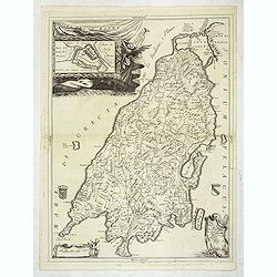
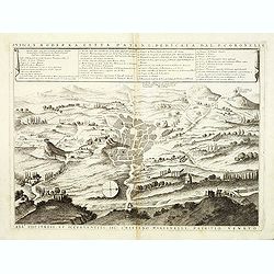
Regno di Negroponte Descritto e Dedicato al Reverendismo. P. Maestro Felice Rotondi . . .ok
A beautiful and flamboyantly engraved large-scale view of Chalkida (Halkida) with in the top right corner an inset map of the island of Evia. With a wide decorative flora...
Date: Venice, 1696
Selling price: ????
Please login to see price!
Sold in 2021
![Pianta della Forterra d'ATENE. . . [Athens]](/uploads/cache/45626-250x250.jpg)
Pianta della Forterra d'ATENE. . . [Athens]
A scarce town-plan showing the fortress and city of Athens, mainly concentrating on classical sites within the city, with a very fine separately printed border consisting...
Date: Venice, 1696
Selling price: ????
Please login to see price!
Sold in 2020
Coron. Parte del Golfo di Coron.
Map of Coron island. The map is set in an ornate border.From Coronelli's rare Atlante Veneto, one of the most decorative and ornate of all 17th century atlases. Engraved ...
Date: Venice, 1696
Selling price: ????
Please login to see price!
Sold in 2022
Grece ou Partie Meridionale de la Turquie en Europe..
From El atlas Abbreviado.
Date: Antwerp 1697
Selling price: ????
Please login to see price!
Sold
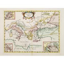
Argonautica.
A very rare map of the Mediterranean Basin, centered on Greece. Decorative title cartouche in the upper part of the map. Three inset maps in upper left-hand corner and lo...
Date: Italy 1697
Selling price: ????
Please login to see price!
Sold
La Grece.
A map of Greece, from Petit et Nouveau Atlas, engraved by C. Inselin and published by Nicolas de Fer.It is to be noted that this particular atlas is scarcer than the othe...
Date: Paris, 1697
Selling price: ????
Please login to see price!
Sold in 2014
Regno di Negroponte Descritto e Dedicato al Reverendismo. P. Maestro Felice Rotondi . . .
A beautiful and flamboyantly engraved large-scale view of Chalkida (Halkida) with in the top right corner an inset map of the island of Evia. With a wide decorative flora...
Date: Venice, 1698
Selling price: ????
Please login to see price!
Sold in 2012
Antica e Moderna Citta d'Atene dedicata dal P. Coronelli. . .
A beautiful and flamboyantly engraved large-scale plan of Ancient Athenes. The map is the product of the late 17th century Venetian cartographer, Vincenzo Coronelli. A de...
Date: Venice, 1698
Selling price: ????
Please login to see price!
Sold in 2012
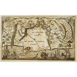
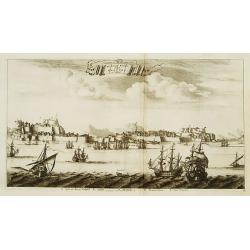
De Nieuwe Stadt / De Oude Stadt Candia.
Rare plan of the town of Candia. With extensive shipping on foreground and Turkish troops sieging the town.The Siege of Candia (Heraklion, Crete) (1648-1669) was possibly...
Date: Netherlands c.1700
Selling price: ????
Please login to see price!
Sold
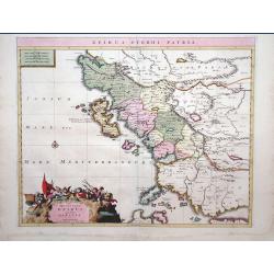
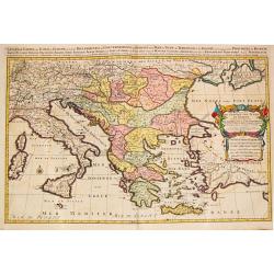
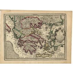
Epirus Pyrrhi Patria / Novantiqua Epirus quae hodie Albania.
A Sanson map of Greece and Albania published by the Covens and Mortier firm.
Date: Amsterdam, 1700
Selling price: ????
Please login to see price!
Sold in 2010
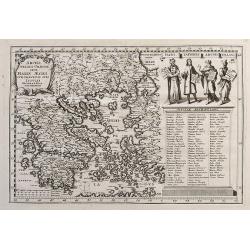
Archipelagi Graeciae Sive Maris Aegei Cum Praecipuis Suis Insulis...
A very detailed map of Greece and its islands. Includes also a portion of Turkey and South East Europe. With a table giving the ancient and modern names of all the island...
Date: Munich, ca.1700
Selling price: ????
Please login to see price!
Sold in 2017
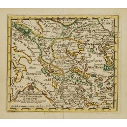
Grece Moderne ou Partie Meridionale de la Turquie en Europe. . .
Small scale, detailed map of Greece, the northern region of Crete, and the eastern coast of Asia Minor by French cartographer Nicholas de Fer.. A bordered title cartouche...
Date: Paris, 1702
Selling price: ????
Please login to see price!
Sold in 2010
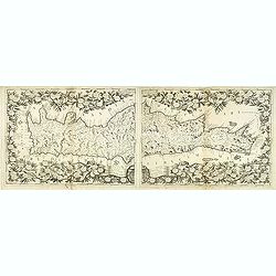
Insularum Archipelagi septentrionalis.
Aegean Islands (North)
Date: Amsterdam, 1703
Selling price: ????
Please login to see price!
Sold in 2010
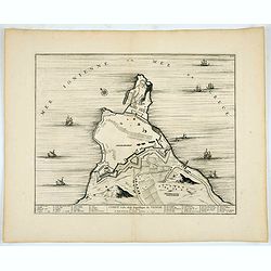
Negroponte.
Penisolur of Negroponte.
Date: Amsterdam, 1703
Selling price: ????
Please login to see price!
Sold in 2010

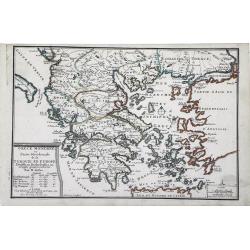
Grece Moderne ou Partie Meridionale de la Turquie en Europe.
A detailed map of the Southern Part of Greece and contiguous Islands. From De Fer's “Atlas Curieux”. Engraved by Van Loon. It comes with a page entitled “Descripti...
Date: Paris, 1705
Selling price: ????
Please login to see price!
Sold in 2021
CORFU Ville de la Republique de VENICE Dans la Dalmatie.
City plan of Corfu, the town and it's fortifications.Joan Blaeu published during his life three town-books of Italy: Citta del Vaticano, Rome and Napoli. By the year 1672...
Date: Amsterdam, 1704/1705
Selling price: ????
Please login to see price!
Sold in 2020
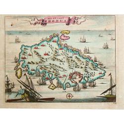
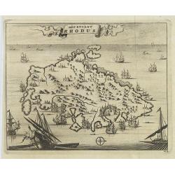
Het Eylant Rhodus.
Pieter van der Aa was a prolific publisher. He published a.o. "Naaukeurige versameling der gedenkwaardigste zee- en land-reysen", a series of accounts of voyage...
Date: Leiden, 1707
Selling price: ????
Please login to see price!
Sold in 2017
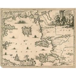
Pascaerte Vande Archipel en de Eylanden.. Candia.. Natolia..
This sea chart covers the Mediterranean coast between the Peloponnese, in Greece, and the Turkish coast facing Rhodes.It is centred in the Aegean Islands and shows Crete ...
Date: Amsterdam, 1708
Selling price: ????
Please login to see price!
Sold
Paskaart Van de Archipelagusche Eylanden..
This sea chart represents the Northern Aegean Islands. It contains an enlarged inset map of the eastern coast of the Chios island as well as one of the gulf of Smyrna, in...
Date: Amsterdam, 1708
Selling price: ????
Please login to see price!
Sold
De stadt Korfu, eertytss Korcyra in 't verschiet.
A beautifully engraved and richly detailed panoramic view of the town of Corfu. In lower part a key to five principal spots in the town. From Galerie Agréable du Monde, ...
Date: Leiden 1712
Selling price: ????
Please login to see price!
Sold
Graecia Sophiani per Abrahamum Ortelium..
A beautifully engraved and richly detailed map of Ancient Greece, after Abraham Ortelius who is given credit in the title. Engraved by J.stemmers.From Galerie Agréable d...
Date: Leiden 1712
Selling price: ????
Please login to see price!
Sold
La Grece..
Nice small map of Greece, with decorative cartouches.
Date: Paris, 1719
Selling price: ????
Please login to see price!
Sold
Isle et Royaume de Candie.
Uncommon small map of Crete displaying precise engraving and a flourishing, banner-style cartouche.From Le Nouveau et Curieux Atlas Geographique et Historique.. by Jacque...
Date: Paris, 1719
Selling price: ????
Please login to see price!
Sold in 2012
La Grece ou Partie Meridionale de la Turquie d'Europe..
Decorative map of Greece displaying precise engraving and a title cartouche flanked by 2 winged female figures, surmounted by a fan shaped shell.Another cartouche contain...
Date: Paris, 1719
Selling price: ????
Please login to see price!
Sold in 2022
La Grece ou Partie Meridionale de la Turquie d'Europe. . .
Decorative map of Greece displaying precise engraving and a title cartouche flanked by 2 winged female figures, surmounted by a fan shaped shell.Another cartouche contain...
Date: Paris, 1719
Selling price: ????
Please login to see price!
Sold in 2017
Isle et Royaume de Candie.
Uncommon small map of Crete displaying precise engraving and a flourishing, banner-style cartouche.From Le Nouveau et Curieux Atlas Geographique et Historique.. by Jacque...
Date: Paris, 1719
Selling price: ????
Please login to see price!
Sold in 2014
Corcyrae insulae, vulgo Corfv planities unacum parte Greciae ..
Corfu with part of the coastline of Greece, large battle-scene title vignette upper right, and panoramic view of Corfu harbour and fortress across the lower portion of th...
Date: Nuremberg 1720
Selling price: ????
Please login to see price!
Sold
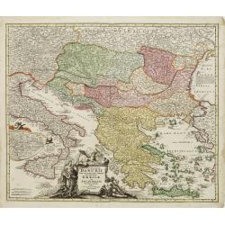
Fluviorum in Europa principis Danubii cum Adiacentibus..
Map showing the course of the river Danube from Ingolstadt to the Black Sea and the adjacent countries with Italy and Greece.In an inset the course of the river Danube fr...
Date: Nuremberg 1720
Selling price: ????
Please login to see price!
Sold
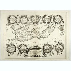
Regnum Moreae accuratissime divisum in Provincias Saccaniam, Tzaconiam, Caliscopium et Ducatum Clarensae, una cum Insulis Cephalonia, Zacyntho, Cythera, Aegina et Sidra
Uncommon map of Greece, by Gerardus Valk and Leonardus Valk in old colors.
Date: Amsterdam, circa 1720
Selling price: ????
Please login to see price!
Sold in 2017
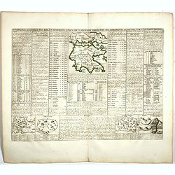
Cronologie Historique des Rois & des différens Etats de l'Ancienne Grèce . . .
Showing in top a map of ancient Greece (130 x 115mm.) with vignette views of the City States of Athens, Thebes and Corinth. The surrounding text details the history of Gr...
Date: Amsterdam, 1720
Selling price: ????
Please login to see price!
Sold in 2022
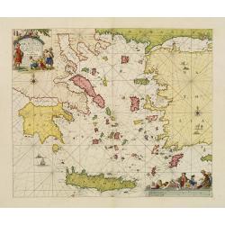
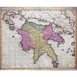
Peloponesus hodie Moreae Regnum...
Large scale map of the Peloponnese, the mainland in the north, and surrounding islands, including Zakynthos and Cephalonia. Shows many details and names, also some notes ...
Date: Nuremberg, ca. 1720
Selling price: ????
Please login to see price!
Sold in 2019
Theatrum belli sive novissima tabula maxima pars Danubii et Hungaria cum alis regnis Graecia, Morea,Archipielago Insula
Engraved map with original hand coloring showing Greece and eastern part of the Mediterranean.
Date: Augsburg 1720
Selling price: ????
Please login to see price!
Sold in 2020
Corcyrae Insula, vulgo Corfu planities unacum parte Greciae.
A scarce map of Greece’s most northerly island, originally drawn by Christoph Weigel, well known as one of the 18th century’s most prolific map makers. To the right o...
Date: Nurnberg, ca 1720
Selling price: ????
Please login to see price!
Sold in 2021
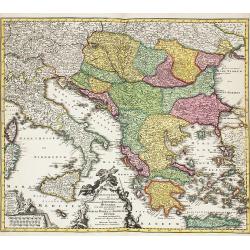
Graeciae Septentrionalis Pars.
A very striking map of northern Greece. From Schul-und-Reisen Atlas..
Date: Nuremberg 1725
Selling price: ????
Please login to see price!
Sold
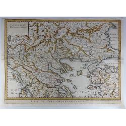
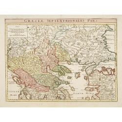
Graeciae Pars Septentrionalis.
A large and dramatic map by de L'Isle of the northern Greece, the Balkans, and Macedonia. Map extent covers from Dalmatia east to the Black Sea (Pontus Euxinus) and south...
Date: London, 1725
Selling price: ????
Please login to see price!
Sold in 2018
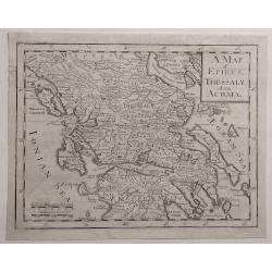
A Map of Epirus, Thessaly and Achaia.
Detailed map of Epirus, Thessaly and Achaia and Peloponnesus in Greece. Cartographer unknown.
Date: ca. 1727
Selling price: ????
Please login to see price!
Sold in 2020
Turquie en Europe, suivant les nouvelles observations..
Uncommon edition of this map of Greece and eastern Turkey. With decorative title cartouche lower left corner.This example is unusual in having the additional separately e...
Date: Amsterdam 1728
Selling price: ????
Please login to see price!
Sold
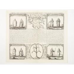
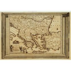
Carte de la Grece contenant l'Etat present de l'Eglise Grecque &..
Handsome chart with a small map of Greece (115 x 150) together with five Greek religious scenes and descriptive French text.
Date: Amsterdam 1728
Selling price: ????
Please login to see price!
Sold in 2009
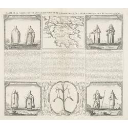
Carte de la Grece contenant l'Etat present de l'Eglise Grecque &..
Handsome chart with a small map of Greece (115 x 150mm.) together with five Greek religious scenes and descriptive French text.
Date: Amsterdam, 1728
Selling price: ????
Please login to see price!
Sold in 2010
Carte historique et géographique de l'ancienne Grece . . .
A map of Greece during the Roman Empire, with descriptive French text, from Chatelain's monumental 7 volume Atlas Historique. In upper right margin: 'N°6.Henri Abraham C...
Date: Amsterdam, 1728
Selling price: ????
Please login to see price!
Sold in 2022
Carte historique chronologique et géographique de l'empire Grec . . .
Interesting sheet with a map of the Roman Empire, with descriptive French text, from Chatelain's monumental 7 volume Atlas Historique.Henri Abraham Chatelain (1684 – 17...
Date: Amsterdam, 1728
Selling price: ????
Please login to see price!
Sold in 2021

Carte de la Grece contenant l'Etat present de l'Eglise Grecque &. . .
Handsome chart with a small map of Greece (115 x 150mm.) together with five Greek religious scenes and descriptive French text.Zacharie Chatelain (d.1723) was the father ...
Date: Amsterdam, 1728
Selling price: ????
Please login to see price!
Sold in 2020
Peloponnesus hodie Morea.
Decorative regional map of Morea and contiguous islands.
Date: Leiden 1729
Selling price: ????
Please login to see price!
Sold
Het Eylant Rhodus.
An attractive bird's eye-view of the island of Rhodes. Pieter van der Aa was a prolific publisher. He published a.o. "Naaukeurige versameling der gedenkwaardigste ze...
Date: Leiden, 1729
Selling price: ????
Please login to see price!
Sold in 2009
Bergh Cinthus ; Sara ; Eylant Cerigo ; Santorini
A beautiful copper engraving by Van Der Aa of 4 Greek islands, all with a very nicely designed border.
Date: 1729
Selling price: ????
Please login to see price!
Sold in 2016
Carte pour la Route de Xerxes dans la Grece et Pour l'Expedition du Jeune Cyprus et la Retraite des Dix Mille.
A striking map of Greece. The map for the Route of Xerxes in Greece and For the Expedition of the Young Cyprus, and the Retreat of the Ten Thousand. It is from “METHODE...
Date: Paris, 1729
Selling price: ????
Please login to see price!
Sold in 2020
Empire et Conquetes d'Allexandre.
A striking map of Greece during the time of 'Alexander the Great,' showing his conquests. It is from “METHODE POUR ETUDIER L’HISTOIRE” by L’Abbe Lenglet du Fresno...
Date: Paris, 1729
Selling price: ????
Please login to see price!
Sold in 2019
Carte Generale de la Grece.
A striking map of Greece. It is from METHODE POUR ETUDIER L’HISTOIRE by L’Abbe Lenglet du Fresnoy, published in Paris in 1729. The map is quite rare and is not now, n...
Date: Paris, 1729
Selling price: ????
Please login to see price!
Sold in 2017
Carte de la Grece pour L'intelleigence de la Guerre de Troye.
A striking map of Greece shown at the time of the war of Troy from the “METHODE POUR ETUDIER L’HISTOIRE” by L’Abbe Lenglet du Fresnoy, published in Paris in 1729....
Date: Paris, 1729
Selling price: ????
Please login to see price!
Sold in 2020
Carte de la Grece.
A striking, large map detailing Greece, the western part of Turkey and extending to show Albania, Macedonia and part of Cyprus. Latin title at top "Accurata Totius A...
Date: Amsterdam, 1730
Selling price: ????
Please login to see price!
Sold in 2008
Antiquorum Illyrici Orientalis ...
Fine map of ancient Greece, Crete and Turkey by Sanson and published by the Covens and Mortier firm. Shows many ancient Greek cities and sites, such as Nicropolis, Athens...
Date: Amsterdam, 1730
Selling price: ????
Please login to see price!
Sold in 2010
Peloponnesus Hodie Morea Ad Normam Veterum Et Recentiorum Mappa Accuratissime Adornata Aeri Incisa Et Venalis. . .
Decorative regional map of Morea and contiguous islands, with an ornate cartouche showing a lion bearing a sword defeating Turkish and other invaders.Matthaus Seutter the...
Date: Augsburg, 1730
Selling price: ????
Please login to see price!
Sold in 2018
Hellas siue Graecia Propria.
A pleasant map of Southern Greece, portraying the ancient geography and cities, including the Pelopenesos, Athens, Corinth, Thebes, Argos, Mycenae and Sparta. With decora...
Date: Leipzig, 1731
Selling price: ????
Please login to see price!
Sold in 2018
Nieuwe Kaart van Europisch Turkyen.
Izaak Tirion (d. 1769) Amsterdam publisher. His ' Nieuwe en beknopte handatlas' saw 6 editions between before 1740 and after 1784. Also ' Tegenwoordige staat van alle vol...
Date: Amsterdam, 1733
Selling price: ????
Please login to see price!
Sold
A New Map of the Islands of the Aegaean Sea, together with the Island of Crete, and the Adjoining Isles
Decorative colored map of the Aegean Sea with Crete and the western part of Turkey. From "A New Sett of Maps both of Antient and Present Geography" by Edward W...
Date: London, 1738
Selling price: ????
Please login to see price!
Sold in 2009
A New Map of Turky in Europe, And Parts of adjoyning
Decorative colored map of Greece, the Balkans and the Western part of Turkey. From "A New Sett of Maps both of Antient and Present Geography" by Edward Wells a...
Date: London, 1738
Selling price: ????
Please login to see price!
Sold in 2009
A New Map of the So. & Mid Parts of Antient Greece viz. Epirus, Hellas, or Graecia Propria, and Peloponnesus, together with Adjoyning Islands
Decorative colored map of the Peloponnese (Morea) in Greece. From "A New Sett of Maps both of Antient and Present Geography" by Edward Wells an English clergym...
Date: London, 1738
Selling price: ????
Please login to see price!
Sold in 2010
Peloponnesus Hodie Morea Ad Normam Veterum Et Recentiorum Mappa Accuratissime Adornata Aeri Incisa Et Venalis. . .
Decorative regional map of Morea and contiguous islands, with an ornate cartouche showing a lion bearing a sword defeating Turkish and other invaders.
Date: Augsburg, 1740
Selling price: ????
Please login to see price!
Sold in 2013
Imperii Turcici Europaei Terra, in primis Graecia. . .
An unusual map showing the Turkish Empire, extending from Corsica and Sardinia in the west, to Asia Minor, Cyprus and the Black Sea in the east. Parts of North Africa als...
Date: Nuremberg, 1740
Selling price: ????
Please login to see price!
Sold in 2017
Imperii Turcici Europaei Terra, in primis Graecia. . .
An unusual map showing the Turkish Empire, extending from Corsica and Sardinia in the west, to Asia Minor, Cyprus and the Black Sea in the east. Parts of North Africa als...
Date: Nuremberg, 1740
Selling price: ????
Please login to see price!
Sold in 2020
Carte de la Grece.(Accurata Totius Archipelagi et Greciae ...
The map was originally issued by G.de L'Isle.
Date: Amsterdam, 1740
Selling price: ????
Please login to see price!
Sold in 2020
Insula Creta nunc Candia. . .
One of the most spectacular maps of Crete, divided into its four territories, and the islands to its north. The lower part is filled with a bird's-eye view of the city of...
Date: Augsburg, 1741
Selling price: ????
Please login to see price!
Sold in 2011
