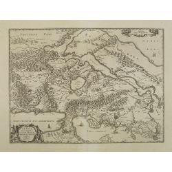
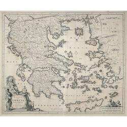
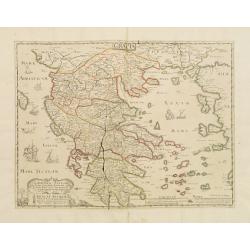
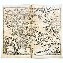
Attica Megarici, Corinthiaca, Boeotia, Phocis Locri.
Fine copperplate engraving of Attica and the surrounding regions with the cities of Athens, Thebes, Opus, and Corinth accentuated. The map is graphically engraved to illu...
Date: Amsterdam 1660
Selling price: ????
Please login to see price!
Sold in 2009
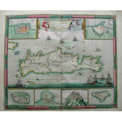
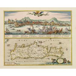
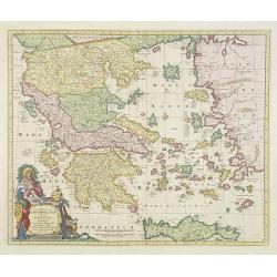
![[Lot of 5 maps of Greece]. Candia olim Creta.](/uploads/cache/IMG_0748-250x250.jpg)
[Lot of 5 maps of Greece]. Candia olim Creta.
Johannes Blaeu's attractive map of Crete. Johan Blaeu succeeded his father Willem when the latter died in 1638. Johan led the Blaeu firm to its greatest achievement the...
Date: Amsterdam, 1660
Selling price: ????
Please login to see price!
Sold in 2023
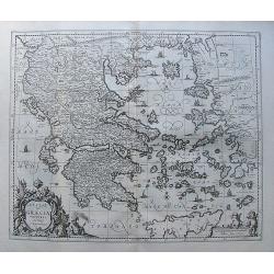
![[Lot of 3 maps] Candia olim Creta.](/uploads/cache/IMG_9432-250x250.jpeg)
[Lot of 3 maps] Candia olim Creta.
Johannes Blaeu's attractive map of Greta. Johan Blaeu succeeded his father Willem when the latter died in 1638. Johan led the Blaeu firm to its greatest achievement the '...
Date: Amsterdam, c. 1660
Selling price: ????
Please login to see price!
Sold in 2022
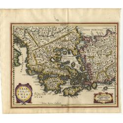
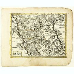
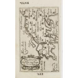
Graecia, Sophiani.
Charming small map of ancient Greece based on the map by Nikolaus Sophianos. Embellished with two strapwork cartouches. Engraved by Petrus Kaerius.
Date: Amsterdam 1661
Selling price: ????
Please login to see price!
Sold
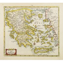
Hellas seu Graecia Universa.
Rare map of Greece, from a book by Cluver Introductionis in Universam Geograpicam published by Johannis Bunonis.A first state.
Date: Wolfenbüttel 1661
Selling price: ????
Please login to see price!
Sold
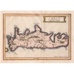
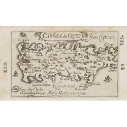
Creta
A small historical map of Crete with a simple strapwork title cartouche. The map is based on the cartography of Ubbo Emmius, who worked for Hondius and Jansson, and engra...
Date: Amsterdam 1661
Selling price: ????
Please login to see price!
Sold in 2014
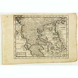
Grece. (36).
Scarce map of Greece published by Antoine de Fer in 1661 or 1662 in "Cartes de géographie revues et augmentées". The series of maps is largely derived from th...
Date: Paris, Antoine de Fer, 1657 but 1661 or 1662
Selling price: ????
Please login to see price!
Sold in 2019
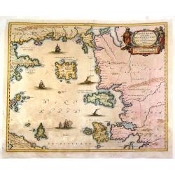
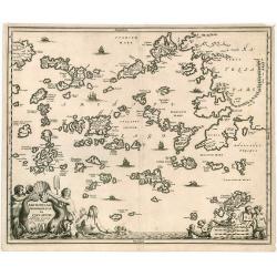
Maris Aegaei Quod hodie Archipelago Nuncupatur, Pars Septentrionalis.
Fine copperplate map featuring the Aeagean Islands of Greece. The map is decorated by a pleasant figural title cartouche and seven detailed ships in the seas. The cartogr...
Date: Amsterdam, 1663
Selling price: ????
Please login to see price!
Sold in 2015
Candia olim Creta. . .
Charming little map of Crete made by Gabriel Bucelin (1599-1681). Bucelin was a Swiss genealogist and an author of several books and a number of manuscript maps of German...
Date: Ulm, Johannes Görlin, 1658-1664
Selling price: ????
Please login to see price!
Sold in 2008
Graecia olim Hellas nunc Rome=ehi, Turris Romechi.
Charming little map of Greece, made by Gabriel Bucelin (1599-1681). Bucelin was a Swiss genealogist and an author of several books and a number of manuscript maps of Germ...
Date: Ulm, Johannes Görlin, 1658-1664
Selling price: ????
Please login to see price!
Sold in 2008
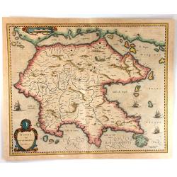
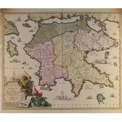
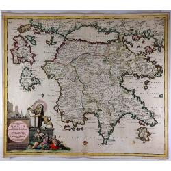
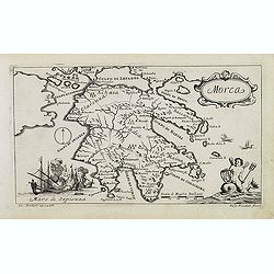
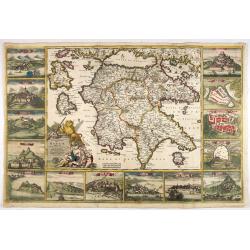
Morea Olim Peloponnesus
An attractive map of the Peloponnesos peninsula in southern Greece that was called Morea until well into the 19th century. The narrow isthmus between the mainland and the...
Date: Amsterdam, 1666
Selling price: ????
Please login to see price!
Sold in 2016
Partie de Turquie. . .
Map of Greece, the Aegean Sea and European part of Turkey prepared by N.Sanson and published by Pierre Mariette.Published in an early edition of the small Sanson atlas L\...
Date: Paris, P. Mariette, 1667
Selling price: ????
Please login to see price!
Sold in 2009
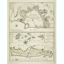
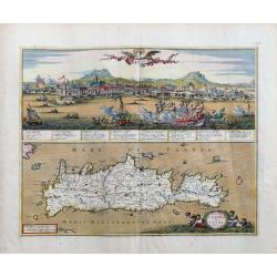
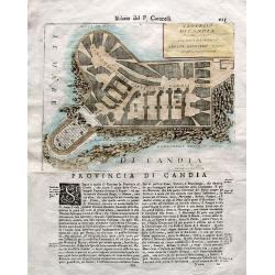
Candie ville metropolitaine de l'Isle de même nom . . . Isle de Candie . . .
Two maps on one sheet: In top Crete's metropolitan town Heraklion with a descriptive text inside the town "Candie ville metropolitaine de méme nom soûmise au grand...
Date: Paris, 1667
Selling price: ????
Please login to see price!
Sold in 2012
Graecia Foederata sub Agamemnone, ob Helenae Raptum in Troiam coniurans . . .
A fine map of the ancient Greece. Engraved by Ludovicus Cordier. Nicolas Sanson was to bring about the rise of French cartography, although the fierce competition of the ...
Date: Paris, 1667
Selling price: ????
Please login to see price!
Sold in 2013
Grece.
Rare map of the Greece, published by Jollain in 1667. Published in "Trésor Des Cartes Geographiques Des Principaux Estats de Lunivers".This atlas is based upon...
Date: Paris, 1667
Selling price: ????
Please login to see price!
Sold in 2021
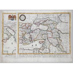
A MAPP of THE ESTATES of the TURKISH EMPIRE in ASIA, and EUROPE, 1669
A rare map of Turkey, Asia Minor, Cyprus, North Africa, Crimea, Southern part of Italy and Eastern Europe . This rare example is the earliest folio sized map of the regio...
Date: London, 1669
Selling price: ????
Please login to see price!
Sold in 2020
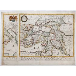
A MAPP of THE ESTATES of the TURKISH EMPIRE in ASIA, and EUROPE, 1669.
A copperplate partly colored map showing Arabie, Asia Minor & Cyprus. This rare example is the earliest folio sized map of the region to be engraved in England by Ric...
Date: London, 1669
Selling price: ????
Please login to see price!
Sold in 2019
Hellas (in Greek) seu Graecia Universa.
Nice and bright map of Greece with the biggest part of Crete (Candia).
Date: Amsterdam, 1670
Selling price: ????
Please login to see price!
Sold in 2010
Insula Candia Ejusque Fortificatio.
Nice map of Crete (candia) with inset maps of Canea, Candia, Suda, Thise, Retimo and Spina Longa in an unusual fresh color.The map is in a strictly contemporary coloring ...
Date: Amsterdam, 1670
Selling price: ????
Please login to see price!
Sold in 2013
Carta del Regno di Candia.
Scarce map of Crete from "Historia di Leopoldo Cesare" by Galeazzo Gualdo Priorato. The map is after a map by Marco Boschini but less detailed in island place-n...
Date: Vienna, 1670
Selling price: ????
Please login to see price!
Sold in 2020
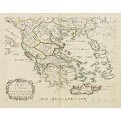
La Grece, ou partie Meridionale de l'Empire des Turcs en Europe, avec le Table Alphabetique des lieux de l'ancienne Grece célèbres en l'Histoire, les noms qu'ils ont aujourd'hui et le chiffre qui les fait trouver . . .
Uncommon map of Greece, widen to Aegean sea with title at bottom. Showing various trade routes from the Dardanelles, Gallipoli and Smyrna through the southern islands and...
Date: Paris, 1674
Selling price: ????
Please login to see price!
Sold
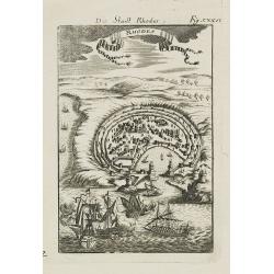
![Negroponte in Morea. [Chalkis].](/uploads/cache/13831-250x250.jpg)
Negroponte in Morea. [Chalkis].
A very nice picture representing the walled city of Chalkis. On the foreground, Alexander and Thais are depicted. With a verse in two languages underneath the picture.The...
Date: Frankfurt 1623-1678
Selling price: ????
Please login to see price!
Sold
![Negroponte in Morea. [Chalkis].](/uploads/cache/13805-250x250.jpg)
Negroponte in Morea. [Chalkis].
A very nice picture representing the walled city of Chalkis. On the foreground, Alexander and Thais are depicted. With a verse in German and Latin underneath the picture....
Date: Frankfurt, 1623-1678
Selling price: ????
Please login to see price!
Sold in 2008
Peloponnesus Hodie Moreae regnum..
Decorative map of the Greece island Peloponnesus.Unfortunately with some holes and browning. Can be restored.Sold as is.
Date: Amsterdam 1680
Selling price: ????
Please login to see price!
Sold
Candia./ Insula Candia olim Creta.
Richly engraved work, one of the most beautiful ever produced maps of Crete.Upper part showing the Turkish siege of the town of Candie.
Date: Amsterdam, 1680
Selling price: ????
Please login to see price!
Sold in 2009
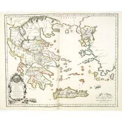
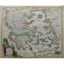
Accurata totius Archipelagi et Graeciae Universae Tabula.
Map of total Greece with all islands.
Date: Amsterdam, 1680
Selling price: ????
Please login to see price!
Sold in 2014
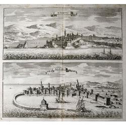
Navarino, Modon.
Two birds- eye town-views on one sheet: Modon and Navarino on the Peloponnese peninsula. Both images show the historically important cities from the seaside with super...
Date: Frankfurt, c1680
Selling price: ????
Please login to see price!
Sold in 2011
Peloponnesus hodie Morea..
Detailed map of the southern part of Greece, including Peloponnesus, Zakinthos, and Kefallinia. Good detail throughout. Large (colored) cartouche depicting a mythical lio...
Date: Amsterdam ca.1680
Selling price: ????
Please login to see price!
Sold in 2014
ΕΛΛΑΣ, Seu Graecia Universa Autore J. Laurenbergio.
Highly detailed map of the whole of Greece, the Greek Islands, the Aegean, Crete and part of Asia Minor.
Date: Amsterdam, 1680
Selling price: ????
Please login to see price!
Sold in 2016
Peloponnesus Hodie Moreae Regnum.
A lovely map of the southern part of Greece / Peloponnese (Pelopónnisos) by Danckerts. With a beautifully colored cartouche with a Venetian Lion fighting against the Tur...
Date: Amsterdam, 1680
Selling price: ????
Please login to see price!
Sold in 2018
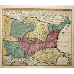
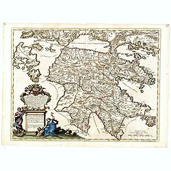
ROMANIA, THRACE, BULGARIA. -Exactissima Tabula qua tam DANUBII FLUVII PARS INFERIOR, . .
A beautifully colored map depicting the region to the lower reaches of the Danube from Belgrade to the Black Sea. Includes all of Romania, Bulgaria, most of Serbia and Th...
Date: Amsterdam, 1680
Selling price: ????
Please login to see price!
Sold in 2021
Insula Candia olim Creta.
Superbly engraved and highly beautiful map of Crete, with a large panorama of Heraklion during the Turkish siege on top. The view is very detailed with a number of shi...
Date: Amsterdam, c1680
Selling price: ????
Please login to see price!
Sold in 2023
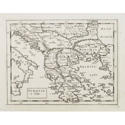
Turquie in Europe.
Extremely rare map of Greece, including also lands adjacent to the Black Sea. From: Jonas Moore, A New Geography with Maps to Each Country. ¤
Date: London, 1681
Selling price: ????
Please login to see price!
Sold
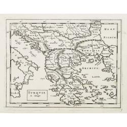
Turquie in Europe.
Extremely rare map of Greece, including also lands adjacent to the Black Sea. From: Jonas Moore, A New Geography with Maps to Each Country, engraved by Herman Moll.
Date: London, 1681
Selling price: ????
Please login to see price!
Sold in 2009
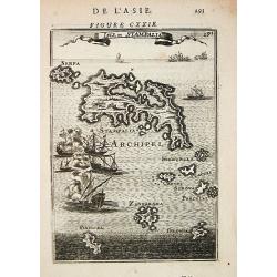
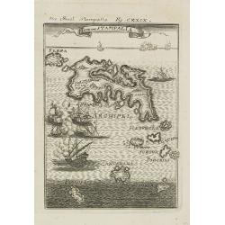
Isle de Stampalia.
Alain Manneson Mallet (1603-1706) published in 1683 his ' Description de l' Univers' in 5 volumes. In 1686 a German edition appeared. A map depicting the island of Stampa...
Date: Paris, 1683
Selling price: ????
Please login to see price!
Sold
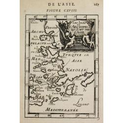
Les Isles de l'Archipel qui sont vers l'Asie.
Alain Manneson Mallet (1603-1706) published in 1683 his ' Description de l' Univers' in 5 volumes. In 1686 a German edition appeared.A map from Alain Manesson Mallet's 'D...
Date: Paris, 1683
Selling price: ????
Please login to see price!
Sold
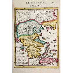
Greece Generale.
Alain Manneson Mallet (1603-1706) published in 1683 his ' Description de l' Univers' in 5 volumes. In 1686 a German edition appeared.Map of Greece.
Date: Paris, 1683
Selling price: ????
Please login to see price!
Sold
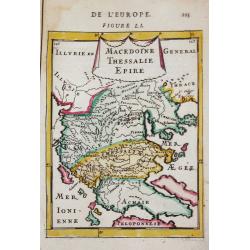
Macedoine, Thessalie, Epire.
Alain Manneson Mallet (1603-1706) published in 1683 his ' Description de l' Univers' in 5 volumes. In 1686 a German edition appeared.Map of northern Greece.
Date: Paris, 1683
Selling price: ????
Please login to see price!
Sold in 2017
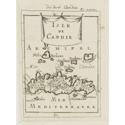
Isle de Candie.
A charming late 17th century French map of Crete and surrounding islands.By Allain Manneson Mallet (1630-1706), a well traveled military engineer and geographer who worke...
Date: Frankfurt, 1684
Selling price: ????
Please login to see price!
Sold in 2009
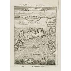
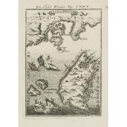
Isle de Samos.
A charming late 17th century map of the Samos Island. Samos is a Greek island in the North Aegean sea, south of Chios, north of Patmos and the Dodecanese, and off the Ion...
Date: Frankfurt, 1684
Selling price: ????
Please login to see price!
Sold in 2010
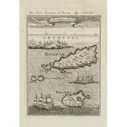
I. de Nicaria et Patmos.
A charming late 17th century map of the Island of Nicaria and Patmos. Located on the eastern borderline of the Aegean Sea, Patmos is the northernmost island of the Dodeca...
Date: Frankfurt, 1684
Selling price: ????
Please login to see price!
Sold in 2011
Rhodes.
A charming late 17th century map of the city of Rhodes. By Allain Manneson Mallet (1630-1706), a well traveled military engineer and geographer who worked in 17th century...
Date: Frankfurt, 1684
Selling price: ????
Please login to see price!
Sold in 2008
Isles de Rhodes.
A charming late 17th century map of the Islands of Rhodes. By Allain Manneson Mallet (1630-1706), a well traveled military engineer and geographer who worked in 17th cent...
Date: Frankfurt, 1684
Selling price: ????
Please login to see price!
Sold in 2009
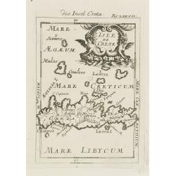
Isle de Crete.
A charming late 17th century map of the Island of Crete. By Allain Manneson Mallet (1630-1706), a well traveled military engineer and geographer who worked in 17th centur...
Date: Frankfurt, 1684
Selling price: ????
Please login to see price!
Sold in 2008
Isle de Stampalia.
A charming late 17th century map of the Stampalia Island. Stampalia is a Greek island which belongs to the Dodecanese, an island group of twelve major islands in the sout...
Date: Frankfurt, 1684
Selling price: ????
Please login to see price!
Sold in 2011
Arcipelago Mar Egeo con le coste del medesimo...
Giacomo Rossi's fine late 17th century map of the Greek Islands. Issued in Il Mercurio geografico In upper right dedicational cartouche, and in the center a tittle cartou...
Date: Rome, 1685
Selling price: ????
Please login to see price!
Sold in 2015
La Grece, ou Partie Meridionale de L'Empire De Turcs en Europe, avec La Table Alphabetique . . .
Uncommon map of the Greek Islands by Pierre Du Val, published in Paris. Shows a number of early sea routes through the islands.
Date: Paris, 1686
Selling price: ????
Please login to see price!
Sold in 2023
Epirus hodie Canina cum Maris Ionii Insulis Corcyra seu Corfu Cephalenia seu Cefalogna etc.
Attractive map of the northwestern coast of Greece and part of present-day Albania. The large allegorical title cartouche features a man with a book representing Wisdom, ...
Date: Wittenberg, 1686
Selling price: ????
Please login to see price!
Sold in 2010
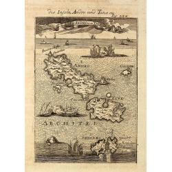
Die Inseln Andro und Tine / I d'Andro et de Tine
Decorative engraved view of the Greek Cyclades Isles Andros and Tinos from Alain Manesson Mallet. With several ship in a sea battle.
Date: Frankfurt, 1686
Selling price: ????
Please login to see price!
Sold in 2010
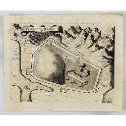
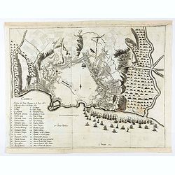
Pianta di Maina.
An interesting map showing the ruins of the fortress in ancient Cersapoli. Tall mountains in the background with a ribbon title cartouche. By Coronelli in Venice in 1686....
Date: Venice, 1686
Selling price: ????
Please login to see price!
Sold in 2018
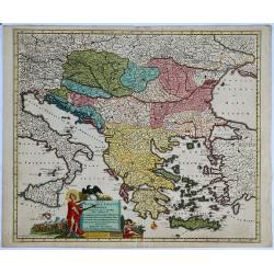
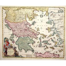
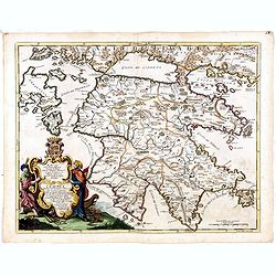
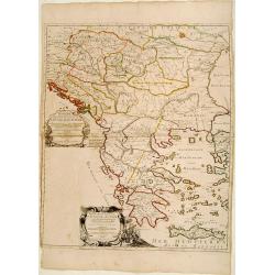
Regni Hungariae, Graeciae et Moreae. . .
A scarce original colored map centred on Greece, extending to all of the Balkans, Hungary, Romania, Aegean Sea and parts of Austria, Italy and Germany of the 17th century...
Date: Amsterdam, before 1686
Selling price: ????
Please login to see price!
Sold in 2019
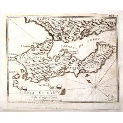
Isola di Corfu.
Little map of the Island of Corfu near Greece by Jan Peeters. From an atlas by Vincenzo Coronelli. It is signed P. Bai. With interesting ribbon title cartouche.
Date: Antwerp, 1687
Selling price: ????
Please login to see price!
Sold in 2015
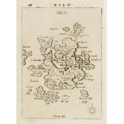
MILO.
Rare map of the island of Milo from Francesco Piacenza's : L'Egeo Redivivo o'sia Chrorographia dell'Arcipelago, e dello stato primiero, & attuale di quell'isole, regn...
Date: Modena, 1688
Selling price: ????
Please login to see price!
Sold
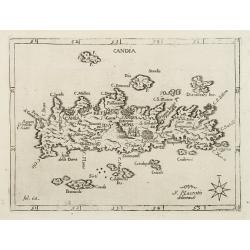
CANDIA
Rare map of the island of Creta from Francesco Piacenza's : L'Egeo Redivivo o'sia Chrorographia dell'Arcipelago, e dello stato primiero, & attuale di quell'isole, reg...
Date: Modena, 1688
Selling price: ????
Please login to see price!
Sold
Archipelagi Meridionalis; seu Cycladum.
Decorative map showing in Greece the Southern Aegean Islands with its neighbouring regions by Dapper/van Meur. An accurate map with many engraved small islands and place ...
Date: Amsterdam, 1688
Selling price: ????
Please login to see price!
Sold in 2009
La Morea Ridotta dall Esemplare Antico nella moderna divisone sue Quatto Parti principali . . .
Rossi's map of Morea and neighboring regions. The engraver was Gasparo Pietra Santa.Issued in second edition of Il Mercurio geografico In lower left corner an ornate titt...
Date: Rome, 1688
Selling price: ????
Please login to see price!
Sold in 2015
Peloponnesus Ad Antiquor . . .
Rossi's map of Peloponnese, based upon Sanson's map, but with revised Italian nomenclature. The engraver was F.D. Messanensis.Issued in Il Mercurio geografico In lower ri...
Date: Rome, 1688
Selling price: ????
Please login to see price!
Sold in 2015
Le Royaume de Hongrie.. Turquie en Europe.. /.. Partie Meridionale de la Turquie en Europe..
Fine map of Hungary and the European part of Turkey.To the lower left a piece of paper is pasted in and the latitudes and longitudes scales are added in print. With the a...
Date: Paris 1689
Selling price: ????
Please login to see price!
Sold
La Macedonia. . . (Northern Greece)
Rossi's map of Northern Greece with Thessaloniki, based upon Sanson's map, but with revised Italian nomenclature. The engraver was Francesco Donia Messis.Issued in a seco...
Date: Rome, 1689
Selling price: ????
Please login to see price!
Sold in 2016
Graeciae Foederata.
A fine map of Ancient Greece.This edition carries the date 1690.Nicolas Sanson was to bring about the rise of French cartography, although the fierce competition of the D...
Date: Paris, 1690
Selling price: ????
Please login to see price!
Sold
Graeciae Antiquae.
A fine map of Ancient Greece prepared by Sanson. A later impression of the copper plate as a large crack in the plate is shown.This edition carries the address of Pierre ...
Date: Paris 1690
Selling price: ????
Please login to see price!
Sold
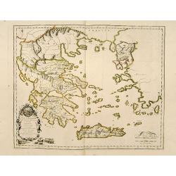
Exactissima totius Archipelagi nec non Graeciae tabula.
Key map of the Greek Islands, the Aegean, Crete and part of Asia Minor.
Date: Amsterdam, 1690
Selling price: ????
Please login to see price!
Sold in 2009
Hellas seu Graecia universa.
From the Hornius edition of the atlas of the Ancient World by Janssonius. No text on verso.After J. Laurenbergio / Nicholas Visscher.
Date: Amsterdam, ca 1690
Selling price: ????
Please login to see price!
Sold in 2012
Attica Megarica.
From the Hornius edition of the Ancient Atlas with Janssonius. No text on verso.Fine copperplate engraving of Attica and the surrounding regions with the cities of Athens...
Date: Amsterdam, ca 1690
Selling price: ????
Please login to see price!
Sold in 2010
Morea.
Fine map of the Island of Morea. Etched by Gaspar Bouttats (1640-1695).The Antwerp based publisher Jacques Peeters published ca. 1690 a series of prints related to the Ha...
Date: Antwerp, c.1690
Selling price: ????
Please login to see price!
Sold in 2013
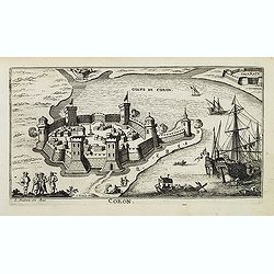
Coron. (Koroni)
Magnificent bird's eye- of Koroni and in the back Molira and Calamata. Etched by Gaspar Bouttats (1640-1695).The Antwerp based publisher Jacques Peeters published ca. 169...
Date: Antwerp, c.1690
Selling price: ????
Please login to see price!
Sold in 2017
Insula di Candia del Mare Mediteranea.
Magnificent map of Crete. Engraved by Coenraad Lauwers.The Antwerp based publisher Jacques Peeters published ca. 1690 a series of prints related to the Habsburg-Ottoman w...
Date: Antwerp, c.1690
Selling price: ????
Please login to see price!
Sold in 2014
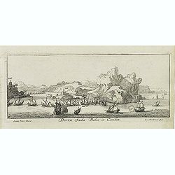
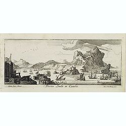
Porta Suda Paleo in Candia. (Harbour of Souda)
Magnificent panoramic of the natural harbour of Souda on the northwest coast of the Greek island of Crete. Engraved by Lucas Vostermans II, who was born in 1624, in the ...
Date: Antwerp, c.1690
Selling price: ????
Please login to see price!
Sold in 2014
Porta Suda Paleo in Candia. (Souda)
Magnificent panoramic view of Souda on Crete. Engraved by Lucas Vostermans II, who was born in 1624, in the same year when the family moved to England for six years. He w...
Date: Antwerp, c.1690
Selling price: ????
Please login to see price!
Sold in 2023
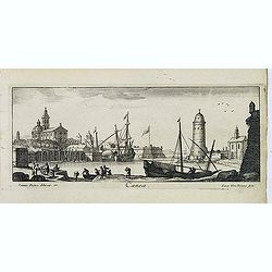
Canea. (Chania)
Magnificent panoramic of Chaniá, the second largest city of Crete. Engraved by Lucas Vostermans II, who was born in 1624, in the same year when the family moved to Engl...
Date: Antwerp, c.1690
Selling price: ????
Please login to see price!
Sold in 2011
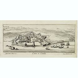
Canea in Candia. (Chania)
Magnificent bird's eye- of Chania. Engraved by Lucas Vostermans II, who was born in 1624, in the same year when the family moved to England for six years. He was back in ...
Date: Antwerp, c.1690
Selling price: ????
Please login to see price!
Sold in 2014
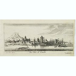
La citta di Candia. (Iraklio)
Magnificent panoramic of Iraklio on Crete. Engraved by Coenraad Lauwers.The Antwerp based publisher Jacques Peeters published ca. 1690 a series of prints related to the ...
Date: Antwerp, c.1690
Selling price: ????
Please login to see price!
Sold in 2011
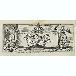
Archipelagi et Graecia Universae.
Centered on Greece. Very decorative title cartouche in the lower left-hand corner.
Date: Amsterdam, 1690
Selling price: ????
Please login to see price!
Sold in 2016
Castello di Candia descritto, e dedicato. . .
An uncommon engraved plan of the castle of Candia (Heraklion, Crete) on a large sheet with Italian text below and on verso. From Coronelli's famous Isolario atlas. Corone...
Date: Venice, ca. 1690
Selling price: ????
Please login to see price!
Sold in 2018
Candia.
A bird's eye view of the town of Heraklion, in Crete, engraved by Bouttats, G. Showing the siege of the Turks in 1667.
Date: Antwerp, ca. 1690
Selling price: ????
Please login to see price!
Sold in 2020
Peloponnesus Hodie Moreae Regnum Distincte Divisum in Omnes suas Provincias . . . Insulae Cefalonia, Zante, Cerigo et St. Maura Acore F. De Wit.
A rare, spectacular map in fine period color of the Peloponnese surrounded by 14 large city, port and fortress views and plans of important Greek cities including Athens,...
Date: Amsterdam, 1690
Selling price: ????
Please login to see price!
Sold in 2022
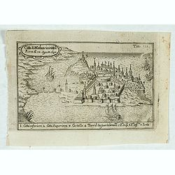
Citta di Malvasia in Mora Reas di 12 Agosto 1690.
Bird's-eye view of the island of Malvasia, nowadays called Monemvasia, with part of the eastern shore of the Peloponnese, showing the island fortress of Monemvasia in Gre...
Date: Italy, after 1690
Selling price: ????
Please login to see price!
Sold in 2023
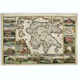
Peloponnesus Hodie Moreae regnum..
A rare, spectacular map of the Peloponnese surrounded by 14 large city, port and fortress views and plans of important Greek cities including Athens, Sparta, Lepanto, Mod...
Date: Amsterdam, 1690
Selling price: ????
Please login to see price!
Sold in 2023
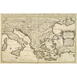
Estats de l'empire des turqs en Europe. . .
Fine map of Greece, Italy, Romania, the Balkan and western part of Turkey. With a decorative title and scale cartouche.Alexis-Hubert Jaillot (1632-1712), was a French car...
Date: Amsterdam, 1692
Selling price: ????
Please login to see price!
Sold in 2009
![Regno di Negroponte. . . [Chalcis]](/uploads/cache/32618-250x250.jpg)
Regno di Negroponte. . . [Chalcis]
Beautiful and rare map of the island Euboea in the Aegean Sea enriched by a perspective view of the city of Chalcis (Negroponte) and important decorations. Vincenzo Maria...
Date: Venice, 1692
Selling price: ????
Please login to see price!
Sold in 2012
