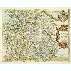
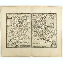
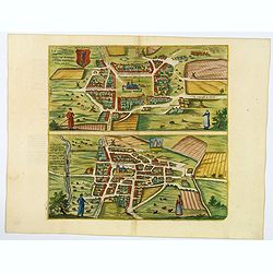
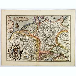
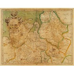
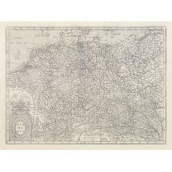
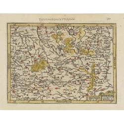
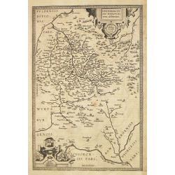
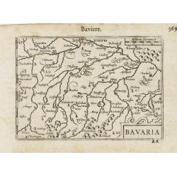
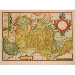
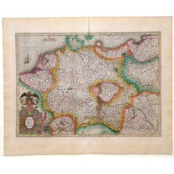
Bavariae, olim vindeliciae delineationis..
Fine and early map of Bavaria, prepared by Philipp Apian in 1561 and used by Ortelius in his atlas 'Theatrum Orbis Terrarum [Atlas of the Whole World]. The Theatrum was r...
Date: Anvers, 1598
Selling price: ????
Please login to see price!
Sold
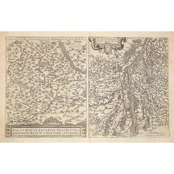
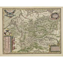
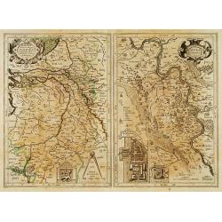
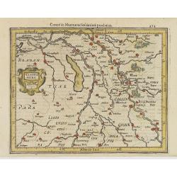
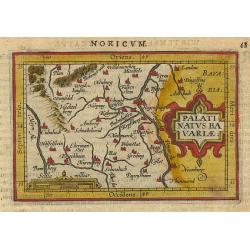
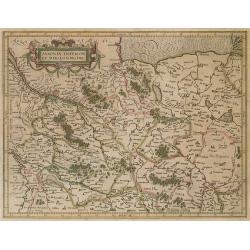
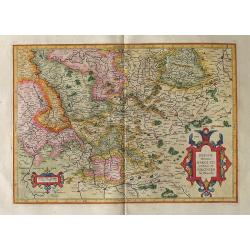
1) Palatinatvs Bavariae .. 2) Argentoratensis agri ..
From 'Theatrum Orbis Terrarum [Atlas of the Whole World]. The left hand map of Bavaria is after Erhart Reych's 4-sheet map of 1540. Including the towns of Regensburg, Nur...
Date: Antwerp, 1598
Selling price: ????
Please login to see price!
Sold in 2016
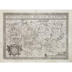
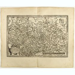
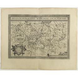
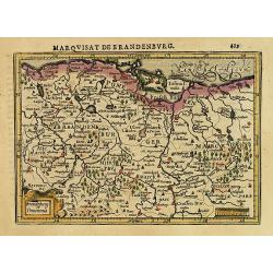
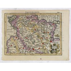
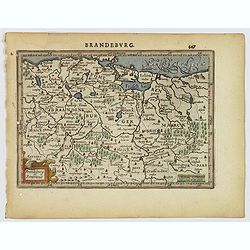
Brandeburgensis Marchiae Descriptio.
A very fine map centered on the towns of Brandenburg and Berlin. Nice title cartouche on the lower left corner.Prepared by Elias Camerius. Abraham Ortelius (1527-1598) wa...
Date: Antwerp, 1598
Selling price: ????
Please login to see price!
Sold in 2011
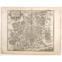
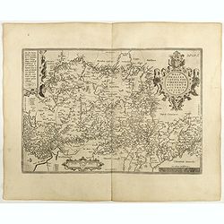
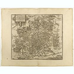
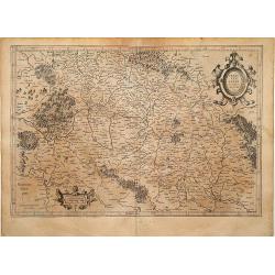
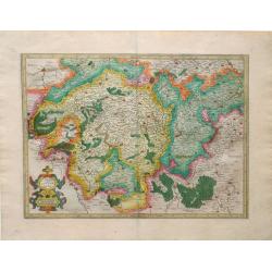
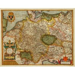
Wirtenberg Ducatus.
Ortelius copied the map after Georg Gadner's map of 1572.Very decorative and a masterpiece in the sense of engraving and composition.
Date: Antwerp, 1598
Selling price: ????
Please login to see price!
Sold in 2016
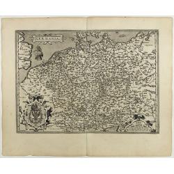
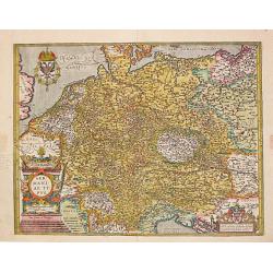
Germania.
General map of Germany, including Switzerland, Austria, The Netherlands and Belgium. Dare to go in Black. All early maps were printed in black and white, and many were...
Date: Antwerp, 1598
Selling price: ????
Please login to see price!
Sold in 2021
Westphaliae . . .
A very fine map of Westphalia prepared by Christian sGroten. A very decorative cartouche on the upper right corner.Abraham Ortelius (1527-1598) was a cartographer and pub...
Date: Antwerp, 1598
Selling price: ????
Please login to see price!
Sold in 2022
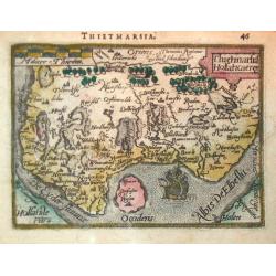
Thietmarsiae Holsaticae . . . (together with) Rugiae . . .
Two maps on one sheet: Left a fine map of Holstein: The island of Rugia and part of Pomerania on the right hand sheet. Abraham Ortelius (1527-1598) was a cartographer and...
Date: Antwerp, 1598
Selling price: ????
Please login to see price!
Sold in 2022
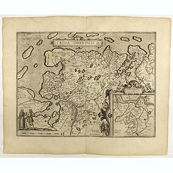
Frisia Orientalis.
Includes the provinces of Friesland. The map was prepared by Jan Bloemmaerts. Dare to go in Black. All early maps were printed in black and white, and many were kept t...
Date: Antwerp, 1598
Selling price: ????
Please login to see price!
Sold in 2023
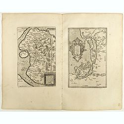
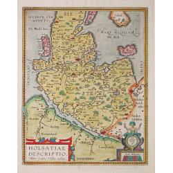
Hassiae Descriptio / Holsatiae Descriptio.
Two maps on one sheet. Left hand presents the province of Hessen, centered on the city of Munich : the right part shows the province of Holstein. Very nice cartouche on t...
Date: Antwerp, 1598
Selling price: ????
Please login to see price!
Sold in 2020
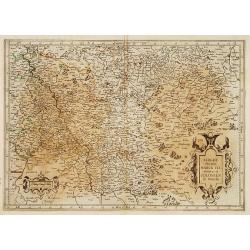
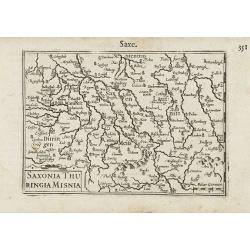
Saxoniae Misniae Thuringiae.
A very fine map of Saxen, Misnie and Thüringen . A very decorative title cartouche on the lower left corner, and a symbolized legend cartouche on the upper right corner....
Date: Antwerp, 1598
Selling price: ????
Please login to see price!
Sold in 2020
Wirtenberg Ducatus . . .
Ortelius copied the map after Georg Gadner's map of 1572.Very decorative and a masterpiece in the sense of engraving and composition.Abraham Ortelius (1527-1598) was a ca...
Date: Antwerp, 1598
Selling price: ????
Please login to see price!
Sold in 2023
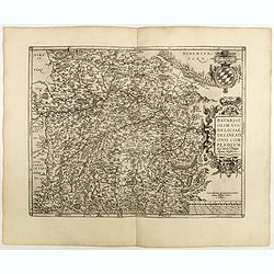
Bavariae, olim vindeliciae delineationis..
Fine and early map of Bavaria, prepared by Philipp Apian in 1561 and used by Ortelius in his atlas 'Theatrum Orbis Terrarum [Atlas of the Whole World]. The Theatrum was r...
Date: Antwerp, 1598
Selling price: ????
Please login to see price!
Sold in 2018
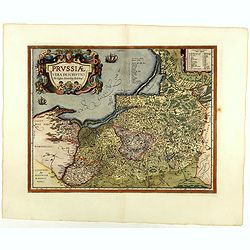
Prussiae descriptio. . .
Fine map of Ortelius' first map of Prussia, with a striking cartouche and two sailing ships, showing part of present day Poland.The map was prepared by Caspar Henneberger...
Date: Antwerp, 1598
Selling price: ????
Please login to see price!
Sold in 2018
Brandeburgensis Marchiae Descriptio.
A very fine map centered on the towns of Brandenburg and Berlin. Nice title cartouche on the lower left corner.Prepared by Elias Camerius. Abraham Ortelius (1527-1598) wa...
Date: Antwerp, 1598
Selling price: ????
Please login to see price!
Sold in 2018
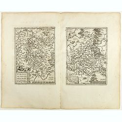
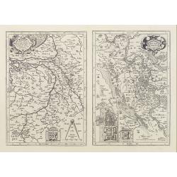
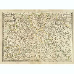
Turingiae Noviss../ Mansfeldiae Comitatus.
Two maps on one sheet. Left hand presents the province of Thüringen and is centered on the city of Erfurt. Nice cartouche on the lower left corner with a credit to the a...
Date: Antwerp, 1598
Selling price: ????
Please login to see price!
Sold in 2020
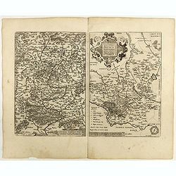
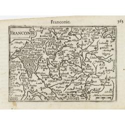
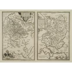
Franciae Orientalis (Vulgo Franckenlant) Descriptio, Avctore, Sebast.A. Rotenhan. (with) Monasteriensis Et Osnaburgensis Episcopatvs Descriptio Auctore Godefrido Mascop Embricense. Cum privilegio.
The map of Frankenland is prepared by Sebastian Rotenhan (1478-1532) and showing the area between Frankfurt and Bamberg. To the right a map Monasteriensis which is after ...
Date: Antwerp, 1598
Selling price: ????
Please login to see price!
Sold in 2018
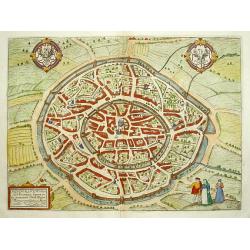
![Wiismaria [Wismar].](/uploads/cache/42766-250x250.jpg)
Wiismaria [Wismar].
Wismar is here shown in a cavalier perspective. The former Hanseatic city on the Baltic rises on the far side of Wismar Bay beyond a broad reach of land. The impressive s...
Date: Cologne, 1598
Selling price: ????
Please login to see price!
Sold in 2020
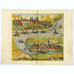
Heide / Meldorf.
Twin perspective bird's-eye views of Heide and Meldorf. HEIDE: The town of Heide is presented in a bird's-eye view from the south. The houses are arranged around the larg...
Date: Cologne, 1598
Selling price: ????
Please login to see price!
Sold in 2019
Tonning / Husum.
A pair of bird's-eye perspective views. TONNING: The illustration of Tönning shows a view across the Eider. The castle with five towers at the center of the town was bui...
Date: Cologne, 1598
Selling price: ????
Please login to see price!
Sold in 2019
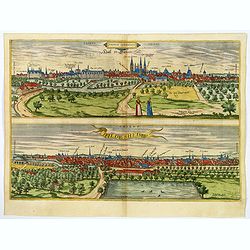
Halle / Hildesheim.
A pair of bird's eye perspective Views of Halle & Hildesheim. Halle is presented in a view across the Saale from the west. Particularly prominent on the skyline - hal...
Date: Cologne, 1598
Selling price: ????
Please login to see price!
Sold in 2020
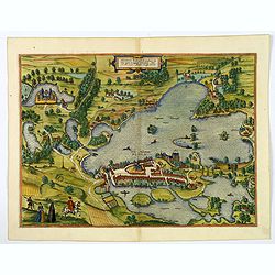
Plon.
Plön is shown in a sweeping bird's-eye view of the countryside surrounding the Greater and Lesser Lake Plön, on which a number of fishermen are seen at work. The palace...
Date: Cologne, 1598
Selling price: ????
Please login to see price!
Sold in 2020
Thietmarsiae Holsaticaereg.
Petrus Bertius (1565- Paris,1629), Dutch cartographer and engraver. Pocket atlas ' Tabularum geographicarum contractarum', 1600-16, ' Totius orbis Terrarum', 1626. Worked...
Date: Amsterdam, c. 1600
Selling price: ????
Please login to see price!
Sold
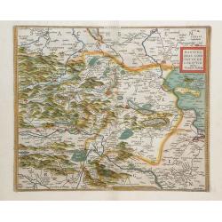
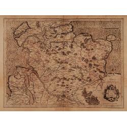
Mansfeldiae Comitatus Descriptioauctore Tilemanno Stella Sig.
Map of the region surrounding the town of Mansfeld (Mansfelt) in central Germany. The manuscript map drawn by Tilemann Stella. Mansfeld is the town that Martin Luther gre...
Date: Antwerp, c. 1600
Selling price: ????
Please login to see price!
Sold in 2010
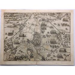
RynBerk (Seige of Rynberk).
This is a very detailed copper engraving with hundreds of identifiable soldiers, horses, fortresses and topographical places. It includes ships in the rivers.The Siege of...
Date: Amsterdam, 1600
Selling price: ????
Please login to see price!
Sold in 2021
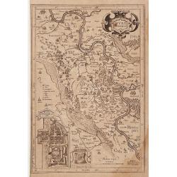
" Mürs Comitatus."
"Detailed and early map centred on Moers, Duisburg and Xanten. With two insets: ""Mürs Oppidum et Arx"" and ""Modiliana"&...
Date: Amsterdam 1602
Selling price: ????
Please login to see price!
Sold
Germania.
A beautiful general map of Germany, including Switzerland, Austria, The Netherlands and Belgium. From a Latin text edition. Based on Christiaan Sgrothen (1520-1608) map o...
Date: Antwerp, ca 1570-1602
Selling price: ????
Please login to see price!
Sold in 2020
GERMANIAE Veteris, typus. Ex conatibus geographicis Abrahami Ortelij.
Historical map of Germany and much of central Europe, including the Low Countries, Poland, Switzerland, Austria and including most important European rivers. According to...
Date: Antwerp, 1603
Selling price: ????
Please login to see price!
Sold in 2011
Franckenlandt Francia Orientalis.
Map centred on Alsace-Lorraine.Mercator was born in Rupelmonde in Flanders and studied in Louvain under Gemma Frisius, Dutch writer, astronomer and mathematician. The exc...
Date: Amsterdam 1606
Selling price: ????
Please login to see price!
Sold
Holsatia ducatus.
Map of Holsatia. Including the town of Hamburg.Mercator was born in Rupelmonde in Flanders and studied in Louvain under Gemma Frisius, Dutch writer, astronomer and mathem...
Date: Amsterdam 1606
Selling price: ????
Please login to see price!
Sold
Westfalia Cum Dioecesi Bremensi.
Map of north western part of Germany. Including the towns of Emden, Bremen, etc and the river Elbe. Decorative title cartouche in the upper left-hand corner.Mercator was ...
Date: Amsterdam 1606
Selling price: ????
Please login to see price!
Sold
Berghe Ducatus Marck Comitatus et Colonien..
Map of the province of Westphalia. Including the River Rhine and the towns of Cologne, Coblenz and Frankfurt. Title cartouche in the lower right-hand corner. With hand-wr...
Date: Amsterdam 1606
Selling price: ????
Please login to see price!
Sold
Murs Comitatus.
Two maps on one sheet: left hand map showing part of the Netherlands with rivers Rhine and Maas. The right hand map the river Rhine from Zanten till Münchengladbach, wit...
Date: Amsterdam 1606
Selling price: ????
Please login to see price!
Sold
Murs Comitatus.
Two maps on one sheet: left hand map showing part of the Netherlands with rivers Rhine and Maas. The right hand map the river Rhine from Zanten till Monchengladbach, with...
Date: Amsterdam, 1606
Selling price: ????
Please login to see price!
Sold
Germania.
Map of Germany by G. Mercator who was born in Rupelmonde in Flanders and studied in Louvain under Gemma Frisius, Dutch writer, astronomer and mathematician.The excellence...
Date: Amsterdam, 1606
Selling price: ????
Please login to see price!
Sold
Trier & Lutzenburg
Map with great original color of areas surrounding the city of Trier, the oldest city in Germany, and Lutzenberg region in northern Switzerland from the Mercator-Hodius a...
Date: Amsterdam, 1606
Selling price: ????
Please login to see price!
Sold in 2010
Saxoniae Superioris Lusatiae Misniaeque. . .
Map depicting part of Saxony and is centered on the towns of Dresden and Meissen.Mercator was born in Rupelmonde in Flanders and studied in Louvain under Gemma Frisius, D...
Date: Amsterdam, 1606
Selling price: ????
Please login to see price!
Sold in 2020
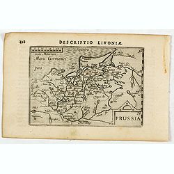
Descriptio Livoniae / Prussia.
A rare miniature map of the area which is now the modern Poland. Title cartouche on the lower right corner.First published in 1598 in his Caert-Thresoor, the plates were ...
Date: Amsterdam, Cornelis Claes, 1606
Selling price: ????
Please login to see price!
Sold in 2016
![Germania. [Set of 15 maps]](/uploads/cache/43325-250x250.jpg)
Germania. [Set of 15 maps]
A lovely miniature set of maps of Germany, as published by Petrus Bertius, in Amsterdam at the beginning of the seventeenth century. The maps have various strap-work titl...
Date: Amsterdam, 1606
Selling price: ????
Please login to see price!
Sold in 2019
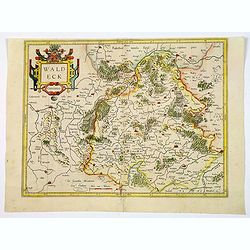
Waldeck Comitatus.
An early regional map by Mercator, centered on the central German towns of Waldeck and Korbach, etc. The map highlights major towns and cities, some highlighted in red, r...
Date: Amsterdam, 1606
Selling price: ????
Please login to see price!
Sold in 2021
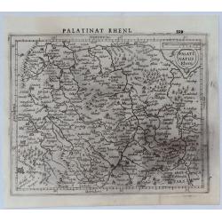
Palatinat Rhen.
A copper engraved map from Mercator's "Atlas Minor", published in 1607. The County Palatine of the Rhine in Germany was later the Electorate of .... Bavarian el...
Date: Amsterdam, 1607
Selling price: ????
Please login to see price!
Sold in 2020
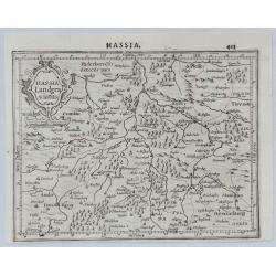
Hassia Landgraviatus.
A copper engraved map from Mercator's "Atlas Minor", published in 1607. Showing the Hesse-Kassel region centred on Kessel, Germany with the course of the Fulda...
Date: Amsterdam, 1607
Selling price: ????
Please login to see price!
Sold in 2020
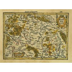
Franckenland.
Detailed map showing part of Germany between Frankfurt and the border with Czech Republic.From the first French-text edition of Jodocus Hondius' Atlas Minor.Shortly after...
Date: Amsterdam, 1608
Selling price: ????
Please login to see price!
Sold in 2019
Brandeburg et Pomerania.
Detailed map showing eastern part of Germany, between Berlin and the Baltic Sea. From the first French-text edition of Jodocus Hondius' Atlas Minor.Shortly after the publ...
Date: Amsterdam, 1608
Selling price: ????
Please login to see price!
Sold in 2022
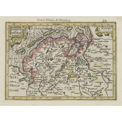
Emden et Oldenbor.
Detailed map of the Northern part of Germany with Emden and Bremen. Nice engraved forests and hundreds of tiny villages.From the first French-text edition of Jodocus Hond...
Date: Amsterdam, 1608
Selling price: ????
Please login to see price!
Sold in 2010
Westphaliae tabula tertia.
Richly detailed map showing part of western Germany between Cologne, Frankfurt and Kassel.From the first French-text edition of Jodocus Hondius' Atlas Minor.Shortly after...
Date: Amsterdam, 1608
Selling price: ????
Please login to see price!
Sold in 2022
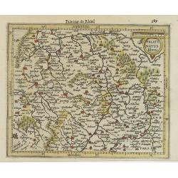
Palatinatus Rheni.
Detailed map showing part of Rhineland-Palatinate. With Ulm, Frankfort, Heidelberg and other major cities of the surrounding area named.From the first French-text edition...
Date: Amsterdam, 1608
Selling price: ????
Please login to see price!
Sold in 2020
Westphaliae tabula II.
Richly detailed map centered on North Rhine-Westphalia. From the first French-text edition of Jodocus Hondius' Atlas Minor.Shortly after the publication of the big folio-...
Date: Amsterdam, 1608
Selling price: ????
Please login to see price!
Sold in 2022
Cleve et Murs.
Map of Cleve, including Eindhoven, Dusseldorf, Aachen, Maastricht, etc. From the first French-text edition of Jodocus Hondius' Atlas Minor.Shortly after the publication o...
Date: Amsterdam, 1608
Selling price: ????
Please login to see price!
Sold in 2019
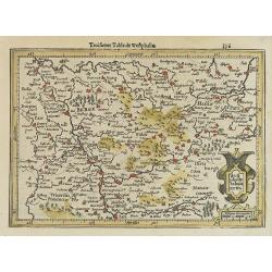
Thuringia.
Detailed map showing the region around Erfurt and Weimar. With major cities of the area named.From the first French-text edition of Jodocus Hondius' Atlas Minor.Shortly a...
Date: Amsterdam, 1608
Selling price: ????
Please login to see price!
Sold in 2020
Holsatia.
Map of Holsatia, including the town of Hamburg. From the first French-text edition of Jodocus Hondius' Atlas Minor.Shortly after the publication of the big folio-atlases ...
Date: Amsterdam, 1608
Selling price: ????
Please login to see price!
Sold in 2017
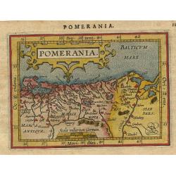
Pomerania.
Miniature map of the Northern part of Germany, with major cities named. Strapwork title cartouche at the top. Sea is stipple engraved. Latin text on verso.
Date: Antwerp 1609
Selling price: ????
Please login to see price!
Sold
Palatinatus Bavariae.
Miniature map of the German part Bavaria, with major cities named; Bamberg, Nuremberg, and Regensburg. Strap work title cartouche at right. Latin text on verso.
Date: Antwerp 1609
Selling price: ????
Please login to see price!
Sold
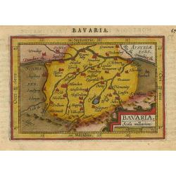
Bavaria.
Miniature map of a part of Germany and Austria, with major cities named like Munchen and Salzburg. Strapwork title cartouche at the bottom. The Chiemsee is stipple engrav...
Date: Antwerp 1609
Selling price: ????
Please login to see price!
Sold
Deutschlanndt / GER: / MANI: / AE TY: / PUS. 1576.
Abraham Ortelius(1527-98), Dutch cartographer and publisher of the first modern atlas, ' Theatrum Orbis Terrarum' in 1570. Editions till 1612. Also an atlas of ancient ca...
Date: Antwerp, Robert Bruneau, 1609
Selling price: ????
Please login to see price!
Sold in 2014
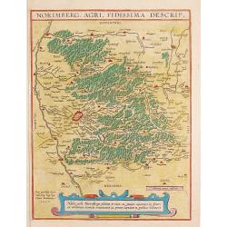
NORIMBERG. AGRI, FIDISSIMA DESCRIP.1590.
Abraham Ortelius(1527-98), Dutch cartographer and publisher of the first modern atlas, "Theatrum Orbis Terrarum" in 1570. Editions till 1612. Also an atlas of a...
Date: Antwerp, Robert Bruneau, 1609
Selling price: ????
Please login to see price!
Sold in 2009
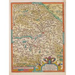
HENNENBERGEN: / SIS DITIONIS. / vera delineatio.
Abraham Ortelius(1527-98), Dutch cartographer and publisher of the first modern atlas, ' Theatrum Orbis Terrarum' in 1570. Editions till 1612. Also an atlas of ancient ca...
Date: Antwerp, Robert Bruneau, 1609
Selling price: ????
Please login to see price!
Sold in 2011
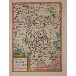
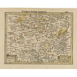
TURINGI: / AE NOVISS. / DESCRIPT.
Abraham Ortelius(1527-98), Dutch cartographer and publisher of the first modern atlas, ' Theatrum Orbis Terrarum' in 1570. Editions till 1612. Also an atlas of ancient ca...
Date: Antwerp, Robert Bruneau, 1609
Selling price: ????
Please login to see price!
Sold in 2014
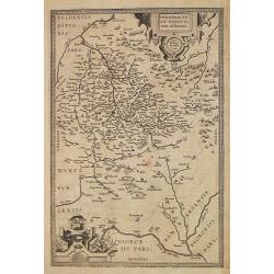
BASILIEN: / SIS TERRITORII / DESCRIPTIO NOVA.
Abraham Ortelius(1527-98), Dutch cartographer and publisher of the first modern atlas, ' Theatrum Orbis Terrarum' in 1570. Editions till 1612. Also an atlas of ancient ca...
Date: Antwerp, Robert Bruneau, 1609
Selling price: ????
Please login to see price!
Sold in 2020
HENNENBERGEN: / SIS DITIONIS. / vera delineatio.
Abraham Ortelius(1527-98), Dutch cartographer and publisher of the first modern atlas, ' Theatrum Orbis Terrarum' in 1570. Editions till 1612. Also an atlas of ancient ca...
Date: Antwerp, Robert Bruneau, 1609
Selling price: ????
Please login to see price!
Sold in 2013
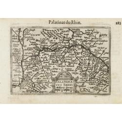
Palatinatus Rheni / Palatinat du Rhin.
A miniature map centered on Heidelberg and Manheim. Title cartouche on the lower part.First published in 1598 in his Caert-Thresoor, the plates were executed by the most ...
Date: Amsterdam/Frankfurt 1609
Selling price: ????
Please login to see price!
Sold
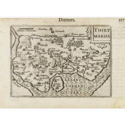
Thiet Marsia.
A miniature map of Holstein. Title cartouche on the upper right corner.First published in 1598 in his Caert-Thresoor, the plates were executed by the most famous engraver...
Date: Amsterdam/Frankfurt 1609
Selling price: ????
Please login to see price!
Sold
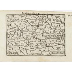
Brandenburg / Marquisat de Brandebourg.
A miniature map of Brandenburg province. The title cartouche on the lower right corner.First published in 1598 in his Caert-Thresoor, the plates were executed by the most...
Date: Amsterdam / Frankfurt, 1609
Selling price: ????
Please login to see price!
Sold in 2022
Saxonia / Thuringia / Misnia.
A miniature map centered on Saxen, Misnie and Thuringen. Title cartouche on the lower left corner.First published in 1598 in his Caert-Thresoor, the plates were executed ...
Date: Amsterdam / Frankfurt, 1609
Selling price: ????
Please login to see price!
Sold in 2021
Franconia.
A miniature map including Frankfort and Nuremberg, Title cartouche on the upper left corner.First published in 1598 in his Caert-Thresoor, the plates were executed by the...
Date: Amsterdam/Frankfurt ,1609
Selling price: ????
Please login to see price!
Sold in 2021
Bavaria.
A miniature map showing a part of Bavaria, including the cities of Innsbruck, Augsburg, Ingolstat, Munich, etc. Title cartouche on the lower right corner.First published ...
Date: Amsterdam/Frankfurt 1609
Selling price: ????
Please login to see price!
Sold
HOLSATIAE / DESCRIPTIO.
Abraham Ortelius(1527-98), Dutch cartographer and publisher of the first modern atlas, 'Theatrum Orbis Terrarum' in 1570. Editions till 1612. Also an atlas of ancient car...
Date: Antwerp, Robert Bruneau, 1609
Selling price: ????
Please login to see price!
Sold
WEST: / PHALIAE / TOTIUS, FINI: / TIMARUMQUE . REGIONUM / ACCURATA / DESCRIP: / TIO. 1579.
Abraham Ortelius(1527-98), Dutch cartographer and publisher of the first modern atlas, ' Theatrum Orbis Terrarum' in 1570. Editions till 1612. Also an atlas of ancient ca...
Date: Antwerp, Robert Bruneau, 1609
Selling price: ????
Please login to see price!
Sold
Saxonie Inferior et Meklenborg Duc.
Mercators Saxony map with gold highlights. French text on verso.
Date: Amsterdam, 1609
Selling price: ????
Please login to see price!
Sold in 2009
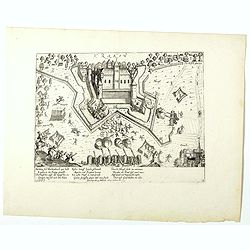
(Krakow Castle near Krefeld)
Rare print of Krakow Castle near Krefeld, besieged from November 4 1605 and captured by Spinola by the troops under the Count of Bucquoy on November 7, 1605.The plates by...
Date: Cologne, 1610
Selling price: ????
Please login to see price!
Sold in 2023
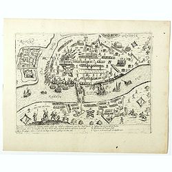
(Siege of the Rhine bridge by Duisburg)
Rare print of siege of the Rhine bridge by Duisburg captured by Spinola by the troops under the Count of Bucquoy on November, 1605.The plates by Hogenberg are dealing wit...
Date: Cologne, 1610
Selling price: ????
Please login to see price!
Sold in 2018
Brandeburg et Pomerania.
A nice small map of Brandenburg and Pomerania, in northeastern Germany, with the western portion of Poland. Berlin is shown roughly in the center of the map. Many larger ...
Date: Amsterdam, 1610
Selling price: ????
Please login to see price!
Sold in 2021
Deutschlanndt/ Germaniae typus ..
Rare map of western Europe prepared by Frans Hogenberg, who published this single sheet map in 1576. Only a few later editions of the Theatrum included this map.According...
Date: Antwerp 1603-1612
Selling price: ????
Please login to see price!
Sold
Aken.
Nice bird's-eye plan of the city of Aken. Based on Braun & Hogenberg's 1572 plan, the map is filled with detail of the well-laid out city and the surrounding countrys...
Date: Amsterdam 1612
Selling price: ????
Please login to see price!
Sold
Hennebergensis ditionis vera delineatio. / Hassiae descriptio..
Two maps on one sheet, also with Schweinfurt and Bamberg.
Date: Antwerp 1612
Selling price: ????
Please login to see price!
Sold
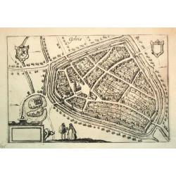
Gelria.
From Ludovico Guicciardini.'s description of the Netherlands ' Beschrijvinghe van alle de Nederlanden anderssins ghenoemt Neder-Duytslandt ', published by Willem Blaeu.A ...
Date: Amsterdam, W.Blaeu, 1612
Selling price: ????
Please login to see price!
Sold in 2020
Bavariae Duces et Palatini Rhenenses. . . fol. XXIX. Otho IIII. comes a Scheuren et Witelspach obiit MCXLVI . . .
A decorative engraving including a family tree of Otho IIII, with coats of arms set against the backdrop of City views of Heidelberg and Munich . Antonio Albizzi (1547-16...
Date: Augsburg, 1612
Selling price: ????
Please login to see price!
Sold in 2009
FRANCKENLANDT Francia orientalis.
Gerard Mercator (1512-94). His ' Atlas sive Cosmographica' was posthumuously published in 1595. Jodocus Hondius (1563-1612), founder of the Hondius publishing house, acqu...
Date: Amsterdam, 1613
Selling price: ????
Please login to see price!
Sold
GERMANIA.
Gerard Mercator (1512-94). His ' Atlas sive Cosmographica' was posthumuously published in 1595. Jodocus Hondius (1563-1612), founder of the Hondius publishing house, acqu...
Date: Amsterdam, 1613
Selling price: ????
Please login to see price!
Sold in 2019
Germania.
Colorful map of Germany and surrounding areas including The Low Counties, Luxembourg, Switzerland, Hungary, Poland and Prussia, from the Mercator/Hondius atlas. Major cit...
Date: Amsterdam, 1613
Selling price: ????
Please login to see price!
Sold in 2010
BERGHE Ducatus MARCK Comitatus et COLONIENsis Diocesis Per Gerardum Mercatorem.
The map covers a large section of the lower Rhine River and the surrounding region, including to Frankfurt and north to Duisburg.9174691746 Gerard Mercator (1512-1594) w...
Date: Amsterdam, (1585-95) 1613
Selling price: ????
Please login to see price!
Sold in 2011
