Browse Listings in Europe > Germany > Germany General Maps
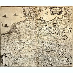
![Ordnung der churfursten des reichs / Die siben churfursten Des heiligen romische reichs. [3 sheets joined with 2 double page views!]](/uploads/cache/84732-250x250.jpg)
Ordnung der churfursten des reichs / Die siben churfursten Des heiligen romische reichs. [3 sheets joined with 2 double page views!]
Three sheets with two double page engravings joined together, with the first showing the then main cities of the Holy Roman Empire of German nation The second shows the E...
Date: Nuremberg, 1493
Selling price: ????
Please login to see price!
Sold in 2020
![[Czech Republic, Germania, Germany, Poland]](/uploads/cache/33866-250x250.jpg)
[Czech Republic, Germania, Germany, Poland]
Wood block printed map and one of earliest printed representation of Czech Republic, Germania, Germany, Poland prepared Martin Waldseemüller. River Rhine to the left. Ba...
Date: Vienna, Trechsel, G., 1525 -1541
Selling price: ????
Please login to see price!
Sold in 2014
![[Map of Caspian Sea and Europe]](/uploads/cache/31513-250x250.jpg)
[Map of Caspian Sea and Europe]
Page with an early representation of Germany. This text page with a fine wood block printed map is from the rare work "C. Iulii Solini Polyhistor, Rerum Toto Orbe Me...
Date: Basle, Michael Isengrin, 1544
Selling price: ????
Please login to see price!
Sold in 2011
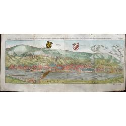
Heidelberg.
One of the two largest woodcuts from the 'Cosmographia' by Sebastian Münster. This is the attractively colored bird-eye view of Heidelberg. It is highly detailed, with a...
Date: Basel, 1544
Selling price: ????
Please login to see price!
Sold in 2019
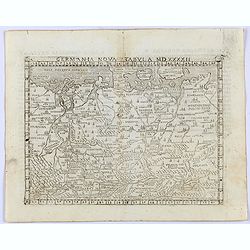
Germania nova Tabula MDXXXXII.
Gastaldi's modern map of Germany, from the Low Countries to Poland in the North and covering Germany and part of Hungary in the South.It is one of the earliest obtainable...
Date: Venice, 1548
Selling price: ????
Please login to see price!
Sold in 2021
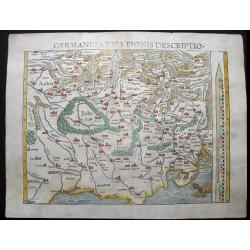
Germanicae Nationis Descriptio.
This charming map was published in the 1550-edition of Sebastian Münster’s Cosmographia. This edition is considered to be Münster’s Magnum Opus. Early Munster's ma...
Date: Basle, 1550
Selling price: ????
Please login to see price!
Sold in 2014
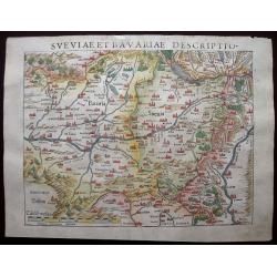
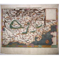
Sveviae et Bavariae Descriptio.
An attractive early woodcut map Bavaria in Southern Germany. The map extends from the source of the Danube through Ulm, Ingolstad, Regensberg and Passau on the Danube, th...
Date: Basle, 1550
Selling price: ????
Please login to see price!
Sold in 2020
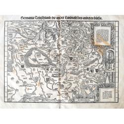
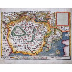
Germania Teutschland/die ander Landtafel des anderen Buchs.
An early woodcut printed map. The fantastic map shows the area between Lübeck, Preßburg, Brixen and Gent. Oriented to the south.Filled with place names, rivers, mountai...
Date: Zurich, ca 1550
Selling price: ????
Please login to see price!
Sold in 2018
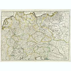
![Die ander Tafel des Rheinstromes, begreiffendt die Pfaltz, Westereich, Eyfel,sc. [Course of the Rhine from approx. Strassbourg to Andernach]](/uploads/cache/84787-250x250.jpg)
Die ander Tafel des Rheinstromes, begreiffendt die Pfaltz, Westereich, Eyfel,sc. [Course of the Rhine from approx. Strassbourg to Andernach]
Wood block map of a part of the course of the Rhine and surrounding lands, by Sebastian Munster.One of the Earliest Modern Maps of the Rhine river. This map is the second...
Date: Basel ca. 1550
Selling price: ????
Please login to see price!
Sold in 2020
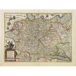
Teutschland,mit seinem gantzen begriff und eingeschlossnen Landschafften.
A fine antique woodcut map of Germany by Sebastian Münster, ca 1550, Basel. From a German edition of his 'Cosmography'.Germany, with parts of the Netherlands, Austria, S...
Date: Basel, ca 1550
Selling price: ????
Please login to see price!
Sold in 2020
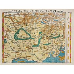
Germania VI Nova Tabula.
Sebastian Münster, 1489-1552, outstanding geographer of Basle. Editied Ptolemy's atlas ' Geographia Universalis', editions 1540,-42, -45, -51 and -52. Published his &quo...
Date: Basle, 1540-1552
Selling price: ????
Please login to see price!
Sold
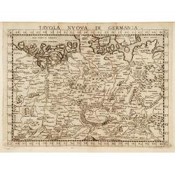
Tavola nuova di Germania.
Map of Germany and parts of the surrounding areas. In the northwest is Flanders and Brabant. In the southwest is Lake Geneva and Budapest is in the southeast. The Vistula...
Date: Venise, 1561
Selling price: ????
Please login to see price!
Sold
![[De Germania - Prinum Suitenfium Foedus]](/uploads/cache/38536-250x250.jpg)
[De Germania - Prinum Suitenfium Foedus]
One Latin text page telling a story from the years 1316-1323. Illustrated with a wonderful wood block print of medieval knights and men shown in a highly stylized primiti...
Date: Basle, ca. 1564
Selling price: ????
Please login to see price!
Sold in 2017
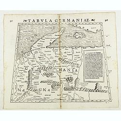
Tabula Germaniae. (Germany)
Double-page woodcut Ptolemaic-style map by Sebastian Münster figuring Germany, published in the edition of Strabo by Henri Petri in 1571."Strabonis rerum geographic...
Date: Basle, Henri Petri, 1571
Selling price: ????
Please login to see price!
Sold in 2018
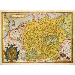
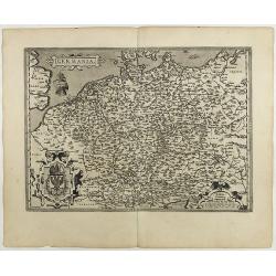
Germania. . .
A map of Germany from Abraham Ortelius’ "Theatrum Orbis Terrarum" is probably based on the map by Christaan Sgrooten. Embellished with a large title-cartouche...
Date: Antwerp, 1571
Selling price: ????
Please login to see price!
Sold in 2021
Teutschland mit seinem gantzen begriff und eingeschlossnen Landschaften
Early woodcut map from Munster's Cosmographey, one of the most influential geographical works of the 16th Century. It shows central Europe, Poland, Germany, Austria, S...
Date: Basle, c1574
Selling price: ????
Please login to see price!
Sold in 2022
Teutschland (Germany)
On recto a wood block printed map of Germany.From a German text edition of his Geographia , that great compendium of Renaissance knowledge.
Date: Basle, 1575
Selling price: ????
Please login to see price!
Sold in 2018
GERMANIA universa, Europae totius..
Map of Germany, Poland, Austria and the Netherlands from the extremely rare first edition.With ''cum priuilegio'' added. Engraved by Joannes and Lucas van Deutecum, who's...
Date: Antwerp 1578
Selling price: ????
Please login to see price!
Sold
Germania.
Ortelius very decorative map of Germania, including Switzerland, Austria, Poland, The Netherlands and Belgium, from 'Theatrum Orbis Terrarum [Atlas of the Whole World]': ...
Date: Antwerp, 1587
Selling price: ????
Please login to see price!
Sold in 2019
Germania.
An attractive map centered on Germany. The sea is decorated with a vessel and a sea monster.From a rare Spanish text edition.
Date: Antwerp, 1588
Selling price: ????
Please login to see price!
Sold in 2009
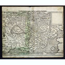
Teutschlandt mit seinem gantzen begriff und eingschlosznen Landschafften.
Early Munster's map of Germaniae or Northern Europe. The map is south-oriented with "west" on the right side and "east" on the left side. Bamberg and ...
Date: Basle, S.H. Petrie, 1588
Selling price: ????
Please login to see price!
Sold in 2014
Schwaben und Bayerlandt darbey auch Begriffen der Otenwald, Nortgow.
An attractive early woodcut map A map of Swabia, one of the ten Imperial Circles of the Holy Roman Empire. Orientated with north at the bottom, it marks Strassburg, Bambe...
Date: Basle, S.H. Petrie, 1588
Selling price: ????
Please login to see price!
Sold in 2020
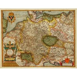
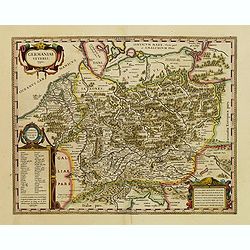
Germaniae Veteris typus.
Made by Ortelius based on the writings by the ancient authors Tacitus, Caesar, Dionysus, Ptolemy, Suetonius, Eutropius, Seneca, Plinius, and Strabo.This map belongs to a ...
Date: Antwerp 1590
Selling price: ????
Please login to see price!
Sold
Germania.
Giovanni Antonio Magini (1555-1617), Italian mathematician and cartographer. Edited edition of Ptolemy's ' Geographia', 1596.The 'modern' map of Germany. An elegantly eng...
Date: Venice, 1596
Selling price: ????
Please login to see price!
Sold in 2018
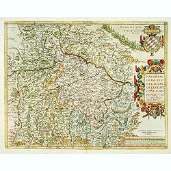
Bavariae, olim vindeliciae delineationis..
Fine and early map of Bavaria, prepared by Philipp Apian in 1561 and used by Ortelius in his atlas 'Theatrum Orbis Terrarum [Atlas of the Whole World]. The Theatrum was r...
Date: Anvers, 1598
Selling price: ????
Please login to see price!
Sold
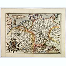
Germania.
General map of Germany, including Switzerland, Austria, The Netherlands and Belgium. Dare to go in Black. All early maps were printed in black and white, and many were...
Date: Antwerp, 1598
Selling price: ????
Please login to see price!
Sold in 2021
Germania.
A beautiful general map of Germany, including Switzerland, Austria, The Netherlands and Belgium. From a Latin text edition. Based on Christiaan Sgrothen (1520-1608) map o...
Date: Antwerp, ca 1570-1602
Selling price: ????
Please login to see price!
Sold in 2020
GERMANIAE Veteris, typus. Ex conatibus geographicis Abrahami Ortelij.
Historical map of Germany and much of central Europe, including the Low Countries, Poland, Switzerland, Austria and including most important European rivers. According to...
Date: Antwerp, 1603
Selling price: ????
Please login to see price!
Sold in 2011
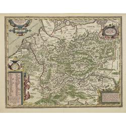
Deutschlanndt / GER: / MANI: / AE TY: / PUS. 1576.
Abraham Ortelius(1527-98), Dutch cartographer and publisher of the first modern atlas, ' Theatrum Orbis Terrarum' in 1570. Editions till 1612. Also an atlas of ancient ca...
Date: Antwerp, Robert Bruneau, 1609
Selling price: ????
Please login to see price!
Sold in 2014
Deutschlanndt/ Germaniae typus ..
Rare map of western Europe prepared by Frans Hogenberg, who published this single sheet map in 1576. Only a few later editions of the Theatrum included this map.According...
Date: Antwerp 1603-1612
Selling price: ????
Please login to see price!
Sold
GERMANIA.
Gerard Mercator (1512-94). His ' Atlas sive Cosmographica' was posthumuously published in 1595. Jodocus Hondius (1563-1612), founder of the Hondius publishing house, acqu...
Date: Amsterdam, 1613
Selling price: ????
Please login to see price!
Sold in 2019
Germania.
Colorful map of Germany and surrounding areas including The Low Counties, Luxembourg, Switzerland, Hungary, Poland and Prussia, from the Mercator/Hondius atlas. Major cit...
Date: Amsterdam, 1613
Selling price: ????
Please login to see price!
Sold in 2010
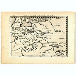
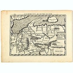
Tractus Rheni in Germania inferiore ad 4 e 5 Historiarum C. Cornelii Taciti.
Map of ancient Germany and the Low Countries, prepared by Petrus Bertius (1565-1629). From "Commentariorum Rerum Germanicarum Libri Tres : Primus est Germaniae veter...
Date: Amsterdam, J.Janssonius, 1616
Selling price: ????
Please login to see price!
Sold in 2015
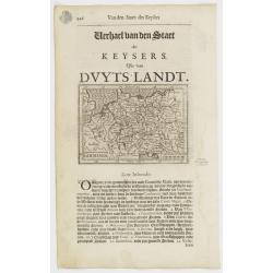
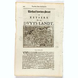
Germaniae descriptio Ptolemaica.
Map of ancient Germany, prepared by Petrus Bertius (1565-1629). From "Commentariorum Rerum Germanicarum Libri Tres : Primus est Germaniae veteris. Secundus, Germania...
Date: Amsterdam, J.Janssonius, 1616
Selling price: ????
Please login to see price!
Sold in 2015
Germania.
Small map of Germany, including Austria, the Czech Republic and part of Poland. Surrounded by text in Dutch.Nicolaes de Clerck (de Klerc) was active as engraver and publi...
Date: Amsterdam, Cloppenburch, 1621
Selling price: ????
Please login to see price!
Sold in 2021
Germania.
Small map of the Germany and Poland. Surrounded by text in Dutch.Nicolaes de Clerck (de Klerc) was active as engraver and publisher in Delft from 1599-1621.Included in th...
Date: Amsterdam, Cloppenburch, 1621
Selling price: ????
Please login to see price!
Sold in 2017

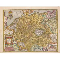
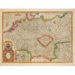
Germaniae nova et accurata delineatio.
This scarce edition with no text verso is signed and dated 1626. This fine engraving shows Germany extending from the Low Countries to Poland and south as far as Switzerl...
Date: Amsterdam, 1626
Selling price: ????
Please login to see price!
Sold in 2013
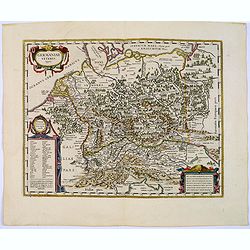
A newe mape of Germany.
A striking, rare, large map of the German Empire, from the famous John Speed's Prospect. It extends from Poland in the Northeast to the Danube. It also includes 'birds-ey...
Date: London, 1626
Selling price: ????
Please login to see price!
Sold in 2017
Germaniae Veteris typus
Attractive map of the Ancient Germany after Abraham Ortelius by Blaeu. From a French edition of "Theatrum orbis terrarum, sive, Atlas novus".
Date: Amsterdam, 1630
Selling price: ????
Please login to see price!
Sold in 2009
Germania.
Copper engraved map of the German empire, which stretches from Holland to Poland and from Switzerland to Hungary. Strapwork title and scale of miles cartouche with a sail...
Date: Amsterdam 1634
Selling price: ????
Please login to see price!
Sold
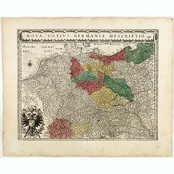
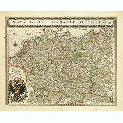
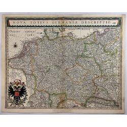
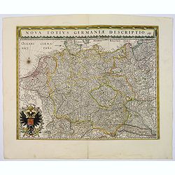
Nova Totius Germaniae Descriptio.
A finely engraved map of the German Empire, including the Netherlands, Germany, Switzerland, Austria, Bohemia, Moravia, Poland and the Baltic Countries. In partial color ...
Date: Amsterdam, 1634
Selling price: ????
Please login to see price!
Sold in 2018
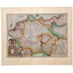
Germaniae veteris typus.
This very attractive and historical map of Germany was concepted after the map of Abraham Ortelius. It shows the area from the North Sea, Poland and Baltic Sea in the nor...
Date: Amsterdam, 1634
Selling price: ????
Please login to see price!
Sold in 2022
Germaniae veteris typus
A very attractive historical map of Germany was concepted after the map of Abraham Ortelius. It shows the area from the North Sea and Baltic Sea in the north to south of ...
Date: Amsterdam, 1635
Selling price: ????
Please login to see price!
Sold
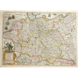
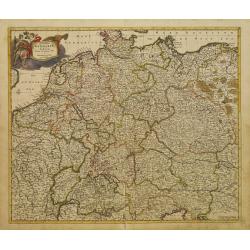
Nova totius germaniae descriptio.
Detailed and finely engraved map of Germany, Poland, Netherlands, Belgium, Austria and a little part of Italy and Croatia. Embellished with an enormous title cartouche al...
Date: Amsterdam, 1635
Selling price: ????
Please login to see price!
Sold in 2018
Germaniae nova et accurata delineatio.. 1631.
Striking example of Hondius' map of the German Empire, extending from the Low Countries in the Northwest to the Baltic and Russia in the Northeast and Italy and the Balka...
Date: Amsterdam 1636
Selling price: ????
Please login to see price!
Sold
Germaniae nova et accurata delineatio.. 1631.
This scarce edition with French text verso is signed and dated 1631. This fine engraving shows Germany extending from the Low Countries to Russia,Poland and south as far ...
Date: Amsterdam, 1636
Selling price: ????
Please login to see price!
Sold in 2013
Germaniae veteris typus
A very attractive historical map of Germany was concepted after the map of Abraham Ortelius. It shows the area from the North Sea and Baltic Sea in the north to south of ...
Date: Amsterdam, 1638
Selling price: ????
Please login to see price!
Sold in 2016
Nova Totius Germaniae Descriptio.
Map of Germany, Low Countries and Poland.As Willem Blaeu died in 1638 most of his maps are actually published by his son Joan. This maps carries his (engraved) signature ...
Date: Amsterdam, 1638
Selling price: ????
Please login to see price!
Sold in 2022
Tabula Germaniae emendata recens. . .
Uncommon map published by Claes Jansz. Visscher covering the Low Countries, Germany, Poland, Switzerland and Austria. Engraved by A. van den Broeck with his signature low...
Date: Amsterdam, 1640
Selling price: ????
Please login to see price!
Sold in 2017
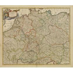
Nova totius germaniae descriptio.
A highly detailed map of the German Empire which covers present-day Germany, Poland, Netherlands, Belgium, Switzerland, Austria, Czech Republic and parts of Poland and Hu...
Date: Amsterdam, 1643
Selling price: ????
Please login to see price!
Sold in 2020
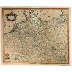
Nova Totius Germaniae Descriptio.
A detailed and finely engraved map of Germany, Poland, Netherlands, Belgium, Austria, and a small part of Italy and Croatia. From the Theatrum Orbis Terrarum.With a titl...
Date: Amsterdam, 1643
Selling price: ????
Please login to see price!
Sold in 2018

Nova Totius Germaniae Descriptio.
As indication in the title cartouche, the map was prepared by the German cartographer Gaspher Henneberg of Erlich. Showing central Europe, including the Netherlands, Belg...
Date: Amsterdam, 1645
Selling price: ????
Please login to see price!
Sold
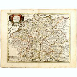
Carte generale de L'Empire d'Allemagne et pays circonvoisins. . .
Early imprint of this fine map of Germany, Poland, Low countries, Switzerland and Austria. The map was first published by Tavernier and later by Mariette. This edition ca...
Date: Paris, 1642 -1645
Selling price: ????
Please login to see price!
Sold in 2023
Nova Totius Germaniae Descriptio.
This map was prepared by the German cartographer Gaspher Henneberg of Erlich. Showing central Europe, including the Netherlands, Belgium, Luxemburg, part of Poland and Hu...
Date: Amsterdam, 1645
Selling price: ????
Please login to see price!
Sold in 2017
Germaniae veteris typus.
A very attractive historical map of Germany that was concepted after the map of Abraham Ortelius. It shows the area from the North Sea and Baltic Sea in the north to sout...
Date: Amsterdam, 1645
Selling price: ????
Please login to see price!
Sold in 2017
Germaniae Antiquae Adiecta.
A pleasant, little, detailed, copper engraved map of ancient Germany. It is enhanced by a strapwork cartouche featuring the face of a cherub.Philippe Briet (1601 - 1668) ...
Date: Paris, 1649
Selling price: ????
Please login to see price!
Sold in 2016
Germaniae Veteris typus.
Map made on the basis of the writings by the ancient authors Tacitus, Caesar, Dionysus, Ptolemy, Suetonius, Eutropius, Seneca, Plinius and Strabo.Showing an substantial p...
Date: Amsterdam 1650
Selling price: ????
Please login to see price!
Sold
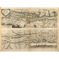
Nobilis Fluvius Albis ... A Ioanne Ianssonio Amstelodami / Emporium Hamburgum
Nice mid 17th century copper engraved map of the course of the Elbe river between Hamburg and the Nordsee by J. Janssonius. With one cartouche and a cityview of Hamburg. ...
Date: Amsterdam, 1650
Selling price: ????
Please login to see price!
Sold in 2009
Germania antiqua. . .
Fine map of ancient Germany, The Netherlands, Belgium, Switzerland, Austria and Poland. The map was first published by Tavernier and later by Mariette. This edition carri...
Date: Paris, 1641-1657
Selling price: ????
Please login to see price!
Sold in 2022
Carte generalle d'allemaigne nouvellement misse en françois et Ampliffiée de tous les Royaumes. . .
Attractive and rare map of Germany, the Low Countries, Austria, Switzerland and part of Poland.
Date: Paris, 1632-1660
Selling price: ????
Please login to see price!
Sold in 2017
Germania.
Small map covering all of central Europe. The map is engraved with detail of rivers, mountains, and forests. Decorative title cartouche. At left of Holland a sailing ship...
Date: Amsterdam 1661
Selling price: ????
Please login to see price!
Sold
Nouvelle carte D'alemagne corigé.
Rare map of Germany, Poland and Switzerland, published by Jollain in 1667. Published in "Trésor Des Cartes Geographiques Des Principaux Estats de Lunivers".Thi...
Date: Paris, 1667
Selling price: ????
Please login to see price!
Sold in 2019
A GENERALL MAPP OF THE EMPIRE OF GERMANY with its severall Estates, 1669
A partly colored map of the German Empire. The earliest folio sized map of the region to be engraved in England.Blome's maps, because of their rarity and importance in th...
Date: London, 1669
Selling price: ????
Please login to see price!
Sold in 2020
GERMANIA vulgo Teutschlandt.
A rare map of Germania by Gualdo Priorato (1606-1678), who entered military service at a very young age and served in Flanders under the Prince of Orange. During his vari...
Date: Vienna, 1672
Selling price: ????
Please login to see price!
Sold in 2018
Accuratissima Germaniae Tabula Denuo in lucem edita.
A very detailed map of central Europe, centred on Germany. It extends from Belgium and The Netherlands through Pomerania in the north, and from eastern France to Croatia ...
Date: Amsterdam 1680
Selling price: ????
Please login to see price!
Sold
Accuratissima Germaniae Tabula Denuo in lucem edita.
A very detailed map of central Europe, centred on Germany. It extends from Belgium and The Netherlands through Poland and from eastern France to Croatia in the south.The ...
Date: Amsterdam 1680
Selling price: ????
Please login to see price!
Sold in 2011
Tabula Germaniae Emendata Recens.
A lovely, detailed 1680 map of Germany, by Hugo Allard. The map covers present-day Germany, Netherlands, Luxembourg, Belgium, part of France, Austria, southern Denmark, ...
Date: Amsterdam, 1680
Selling price: ????
Please login to see price!
Sold in 2021
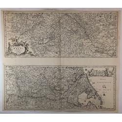
Totius Fluminis Rheni Novissima Descriptio. . .
Two maps on one sheet, one above the other, charting the course of the Rhine River., beginning on the top map, from its source at the Bodensee in Switzerland, through the...
Date: Amsterdam, 1680
Selling price: ????
Please login to see price!
Sold in 2018
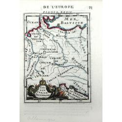
Les Dix Cercles d'Allemagne
Small scale map of Germany (the Holy Roman Empire) by Allain Manesson Mallet's Description de L'Univers. Also includes the surrounding areas of France, Poland and Hungary...
Date: Paris, 1683
Selling price: ????
Please login to see price!
Sold in 2010
L'Empire D'Allemagne Divise En Tous Se Estats al Usage de Monseigneur le Duc De Bourgogne...
Rare map of the German Empire, which appeared in Jaillot's rare atlas dedicated to the Duke of Bourgogne and in later composite atlases. Two elaborate cartouches, includi...
Date: Paris, 1684
Selling price: ????
Please login to see price!
Sold in 2021
Imperto d'Allemagna diuiso in dieci Cerchi quali Cerchi...
Giacomo Rossi's fine late 17th century map of Germany. Issued in Il Mercurio geografico In upper left hand corner large title cartouche.The cartographer was Giacomo Cante...
Date: Rome, 1673-1688
Selling price: ????
Please login to see price!
Sold in 2015
Germania Antiqua.
A fine map of ancient Germany, Poland and the Netherlands.This edition carries the date 1690 in manuscript.Nicolas Sanson was to bring about the rise of French cartograph...
Date: Paris, 1690
Selling price: ????
Please login to see price!
Sold in 2010

Julius Franciscus D.G. Saxon . . .
Equestrian portrait of Julius Franciscus, full-length in profile to left but looking at the viewer, horse seen in frontal view, after Pieter Stevens ( c.1683-1692).This i...
Date: Antwerp, c.1690
Selling price: ????
Please login to see price!
Sold in 2019
Germania Parte Occidentale, Dedicata Al Reuerendissimo Padre D. Serafino Pasolino Nella Congreg Lateranense ...
Detailed map of Western Europe by Vincenzo Coronelli, showing the Holy Roman Empire. This beautiful map covers from the Baltic in the north to Venice in the south. In the...
Date: Venice, 1691
Selling price: ????
Please login to see price!
Sold in 2014
Parte Orientale Della Germania Diuisa Ne Suoi Stati. . .
Detailed map of Eastern Europe by Vincenzo Coronelli, showing the eastern portion of the Holy Roman Empire. Includes regions of eastern Germany, Bohemia, Austria, Norther...
Date: Venice, 1692
Selling price: ????
Please login to see price!
Sold in 2010
L'Empire D'Allemagne distingue suivant l'estendu de tous les estats, . . .
Fine map of Germany, Low Countries, Poland and eastern Europe with a decorative title and scale cartouche.Alexis-Hubert Jaillot (1632-1712), was a French cartographer. He...
Date: Amsterdam, 1692
Selling price: ????
Please login to see price!
Sold in 2014
Le Cours de la Riviere du Rhein / depuis sa Source a son Embouchure./ A Paris, 1692.
Alexis-Hubert Jaillot (1632-1712), French cartographer. He joined the Sanson heirs and redrew Nicolas Sanson's maps on a larger scale. 'Atlas Nouveau' (1674), sea-atlas '...
Date: Amsterdam, 1696
Selling price: ????
Please login to see price!
Sold
L\' Empire d\' Allemagne / distingue suivant l\' etendue de tous / les Estats, Principautes et Souverainetes. A Paris, 1696.
Alexis-Hubert Jaillot (1632-1712), French cartographer. He joined the Sanson heirs and redrew Nicolas Sanson's maps on a larger scale. 'Atlas Nouveau' (1674), sea-atlas '...
Date: Amsterdam, 1696
Selling price: ????
Please login to see price!
Sold in 2010
Lot of 3 maps of Germany.
Robert de Vaugondy: Empire d'Allemagne, 24 cm x 28 cm. Van der AA : Cercle du Haut Rhin, 22,5cm x 29 cm: L'Allemagne, 22,5 cm x 29 cm.The three maps are well-engraved.
Date: Paris/ Leiden, 1700
Selling price: ????
Please login to see price!
Sold
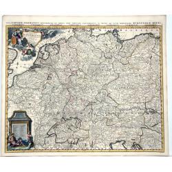
Nova et Prae Caeteris Alis Correcta Germaniae Tubula Comprehendens Accuratam X. Circulorum, Bohemiae, Regni, AC Univerfae Helvetia Defcriptionem, Cum Divifione in Caeterais Partes.
An overall map of Western Europe by Frederick De Witt which includes Saxony, France, Poland, Bohemia, and parts of Northern Italy down to the Venetian Gulf. Major cities ...
Date: Amsterdam, cira 1700
Selling price: ????
Please login to see price!
Sold in 2010
