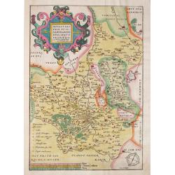
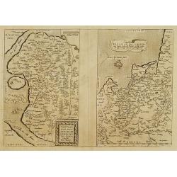
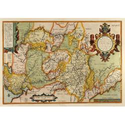
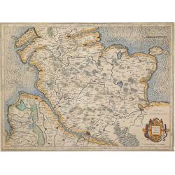
Browse Listings in Europe > Germany > German Provinces
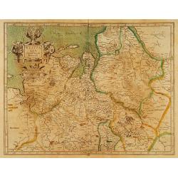
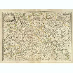
![Partie septentrionale du cercle de Haute Saxe [...] Brandebourg.](/uploads/cache/36760-250x250.jpg)
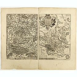
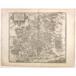
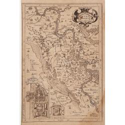
Partie septentrionale du cercle de Haute Saxe [...] Brandebourg.
Finely and crisply engraved map of north eastern part of Germany, including part of Poland. With inset map of Brandenburg. Prepared by Giles Didier Robert De Vaugondy wit...
Date: Venice, 1178
Selling price: ????
Please login to see price!
Sold in 2016
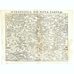
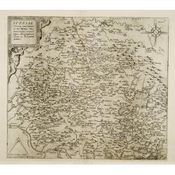
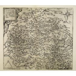
Franconia XII Nova Tabula.
Detailed regional map of Germany, centered on Bamberg and the Mein River. One of the earliest obtainable modern maps of the region. From the 1542 edition of Münster's Ge...
Date: Basle, ca. 1542
Selling price: ????
Please login to see price!
Sold in 2017
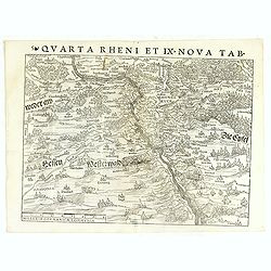
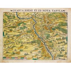
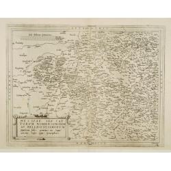
Quarta Rheni et IX Nova Tab.
Highly detailed regional map of the course of the Rhine, from Mainz to Bonn, one of the first obtainable modern maps of the region. Extremely detailed for the period. The...
Date: Basle, ca. 1542
Selling price: ????
Please login to see price!
Sold in 2017
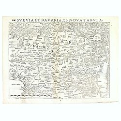
Svevia et Bavaria XII, Nova Tabula.
A highly decorative woodcut map by famous mapmaker Sebastian Münster published in his Ptolemy edition 1552 in Basel at Heinrich Petri. The decorative woodcut bordures ve...
Date: Basle, ca. 1542
Selling price: ????
Please login to see price!
Sold in 2016
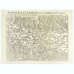
Alsatia et Brisgoia II Rheni Et VII Nova Tabula.
Detailed map of the Rhine River Valley, from Strasburg and Argentina to Basel and Laufenberg, centered on Brisach and Kappel and showing Colmar. West is at the top of the...
Date: Basle, ca. 1542
Selling price: ????
Please login to see price!
Sold in 2019
Quarta Rhein et IX Nova Tabula.
Sebastian Münster, 1489-1552, outstanding geographer of Basle. Edited Ptolemy's atlas 'Geographia Universalis', editions 1540,-42, -45, -51 and -52. Published his 'Cosmo...
Date: Basle, c. 1550
Selling price: ????
Please login to see price!
Sold in 2008
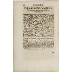
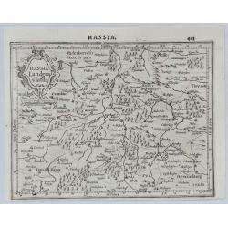
Hessen.
RECTO: A map of the city of Hessen in Germany illustrated in lower right portion by a woodcut of a scholar.Taken from Sebastian Münster's encyclopedic work, the Cosmogra...
Date: Basle, ca. 1564
Selling price: ????
Please login to see price!
Sold in 2012
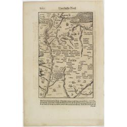
Eyfalia.
RECTO: a map of the area around Cologne, including the Dutch province Limburg and part of Luxemburg. VERSO: a woodcut of a Turkish bath scene and the its outside surround...
Date: Basle, ca. 1564
Selling price: ????
Please login to see price!
Sold in 2009
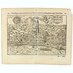
Die Nordlingen Stat.
Interesting woodblock view of the medieval town of Nordlingen, today Riess, in Bayern.Individual landmarks and buildings are named as well as farms and other points of in...
Date: Basel, 1552 - 1568
Selling price: ????
Please login to see price!
Sold in 2016
Monasteriensis et Osnaburgensis Episcopatus descriptio.
Abraham Ortelius(1527-98), Dutch cartographer and publisher of the first modern atlas, Theatrum Orbis Terrarum in 1570. Editions till 1612. Also an atlas of ancient carto...
Date: Antwerp, 1571
Selling price: ????
Please login to see price!
Sold in 2008
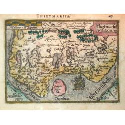
Thietmarsiae, Holsaticae regionis partis typus.
Fine map of Holstein.
Date: Antwerp 1574
Selling price: ????
Please login to see price!
Sold
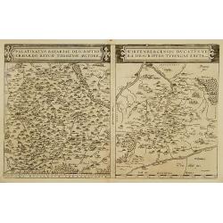
Palatinatus Bavariae descriptio.../ Wirtenbergensis Ducatus...
Two maps on one sheet. Covering the Danube and Regensburg. The map on the right hand side centered on Stuttgart.
Date: Antwerp 1574
Selling price: ????
Please login to see price!
Sold
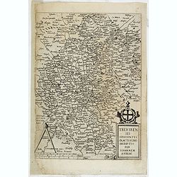
Trevirensis Episcopatus Exactissimo Decriptio Per Iohannem Scilde.
Map of Trier, prepared by J. van Schilde and engraved by Johan van Doetichum. From the first edition of De Jode's Speculum Orbis Terrarum, the second general atlas of the...
Date: Antwerp, 1578
Selling price: ????
Please login to see price!
Sold in 2015
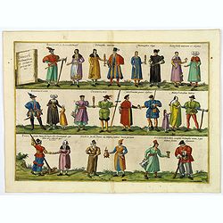
Diversi Dithmarsorum et vicinarum gentium habitus.
An interesting and unusual print of the various costumes from Dithmarschen and the surrounding areas. This print is made up of three rows of assorted costumed peoples. So...
Date: Cologne, 1578
Selling price: ????
Please login to see price!
Sold in 2020
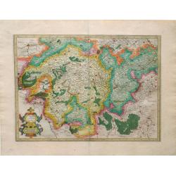
![[Bavaria]](/uploads/cache/11359-250x250.jpg)
[Bavaria]
Very early map of Bavaria, centered on Regensburg, including the towns of Augsburg, Salzburg, Pasaw, etc. On verso wood cut prints of two pigs and a worker. Size of the s...
Date: Basle 1580
Selling price: ????
Please login to see price!
Sold
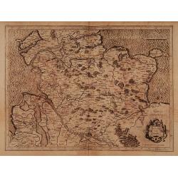
![[Bavaria]](/uploads/cache/11360-250x250.jpg)
[Bavaria]
Very early map of Bavaria, Including the towns of Nurnberg, Pilsen, Landaw, Ingolstadt, etc. On verso wood cut prints of coats of arms. Size of the sheet is 31x20cm.From ...
Date: Basle 1580
Selling price: ????
Please login to see price!
Sold in 2011

Westphaliae Totius, Finitimarumque Regionum Accurata Descriptio.
A very beautiful hand color copper engraved map of North Rhein-Westphalia by A. Ortelius. From the 1584 Latin edition of the "Theatrum Orbis Terrarum". This is ...
Date: Antwerp, ca 1584
Selling price: ????
Please login to see price!
Sold in 2019
Westphaliae Totius, Finitimarumque Regionum Accurata Descriptio
Beautiful hand color copper engraved map of North Rhein-Westphalia by A. Ortelius. From the 1584 Latin edition of \"Theatrum Orbis Terrarum\".
Date: Antwerp, 1584
Selling price: ????
Please login to see price!
Sold in 2009
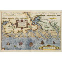
Beschrijvinghe van de zee custen van Ooft Vriesslandt. . .
A detailed chart of the Groeninger region situated at the southern tip of the Jutland Peninsula. Decorated by a title, scale and a descriptive cartouche, one compass rose...
Date: Leiden, Plantijn, 1585
Selling price: ????
Please login to see price!
Sold in 2013
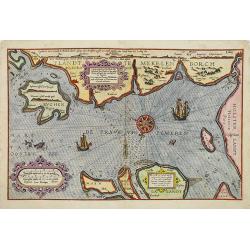
Caerte vande zee custe va Mekelenborch, Soe de Landen. . . Tot Femeren. . .
A rare Dutch text edition of this early detailed chart with the island of Rügen to the feft, the coastline of Mecklenburgh and Fehmarnbelt with the island of Fehmarn. No...
Date: Leiden, Plantijn, 1585
Selling price: ????
Please login to see price!
Sold in 2017
Descriptio ditionum littoralium maris Germanici, videlicet, Eijderstadij, Dithmarsiae. . .
A detailed chart of the Dithmarschen region in the North coastline of Germany. Decorated by a title, scale and a descriptive cartouche, one compass rose, several vessels ...
Date: Leiden, Plantijn, 1585
Selling price: ????
Please login to see price!
Sold in 2008
Beschrijvinghe der Zee Custen van Eiderste, Dithmers, en ee deel vant Fromges landt, ...
Sea chart by Waghenaer. Latin text on verso.
Date: Leiden, 1586
Selling price: ????
Please login to see price!
Sold in 2009
Franckenlandt am Mayn, beschriben nach aller Gelegenheit, in Stetten, Bergen, Wässern, Wäldern, und anstossenden Ländern
Detailed map of Southern Germany around the river Main, from the 1588-German edition of Munster's Cosmography. Mountains, villages, churches and woods are attractively dr...
Date: Basle, S.H. Petrie, 1588
Selling price: ????
Please login to see price!
Sold in 2019
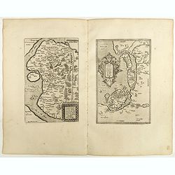
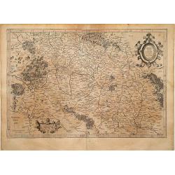
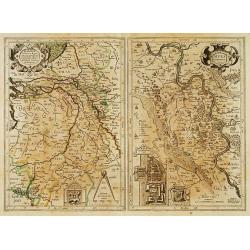
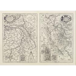
![[Two maps of Germany]](/uploads/cache/14379-250x250.jpg)
[Two maps of Germany]
Two sheets. One map centered on the river Rhine with the towns of Basle, Zürich, Augsburg, Esling, Strasbourg, Fribourg, etc. The second map showing eastern part of Germ...
Date: Basle 1550-1590
Selling price: ????
Please login to see price!
Sold
Thietmarsiae, Holsaticae Regionis Partis Typvs. Auctore Petro Boeckel. / Oldenbvrg Comit.
Two engraved maps on a folio sheet by Petro Boeckel of Germany. Published by Abraham Ortelius (1527-98) in his "Theatrum Orbis Terrarum".
Date: Antwerp, c.1590
Selling price: ????
Please login to see price!
Sold in 2010
Braunsvicensis et Luneburgensis Ducatuum.
Early map of Brunswick and Lunenburg. Nice cartouche on the upper right corner.Abraham Ortelius (1527-1598) was a cartographer and publisher, who is born and died in Antw...
Date: Antwerp 1590
Selling price: ????
Please login to see price!
Sold
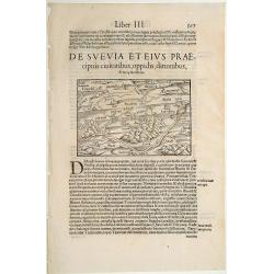
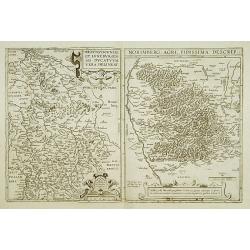
De Suevia et eius Praecipuis Civitatibus..
On recto an early map of south eastern part of Germany, including the towns of Fribourg, Zürich, Basel, Strasbourg, Heidelberg, Spire, etc. (Map : 117x155 mm).From a Lat...
Date: Basle, 1550-1590
Selling price: ????
Please login to see price!
Sold in 2014
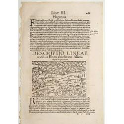
Descriptio Lineae Occiduae Rheni .. / Alsatia.
On recto an early map of the province of Alsace, with Strasbourg, Heidelberg and Metz. (Map : 88x135 mm).From a Latin text edition of his Geographia , that great compendi...
Date: Basle, 1550-1590
Selling price: ????
Please login to see price!
Sold in 2014
![Von dem Teutschen land. [Northern Germany]](/uploads/cache/45680-250x250.jpg)
Von dem Teutschen land. [Northern Germany]
A nice small map of northern Germany and a part of Poland. Shows the area between Lignitz and Torgau in the south, in the north Gdansk, the Baltic Sea and Holstein, in th...
Date: Basle, ca 1590
Selling price: ????
Please login to see price!
Sold in 2021
Lipsia..
On recto an early map of Germany, centered on Leipzig (117x155 mm).From a Latin text edition of his Geographia , that great compendium of Renaissance knowledge.
Date: Basle, 1550-1590
Selling price: ????
Please login to see price!
Sold in 2014
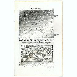
Saxonia Vetus et Nova . . .
Text sheet with on recto an early map of Saxony, centered on Berlin and including Hamburg and Danzig as well (map : 69x134 mm). South to the top.From a Latin text edition...
Date: Basle 1550-1590
Selling price: ????
Please login to see price!
Sold in 2017
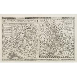
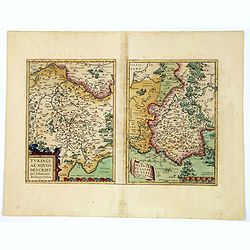
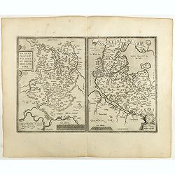
Turingiae Comitatus Provincialis - Misniae Marchionatus
2 maps on one plate depicting the German states of Thüringen and Saxony. Centered respectively on Erfurt and Dresden.Gerard De Jode was the great rival of Ortelius, both...
Date: Antwerp, 1593
Selling price: ????
Please login to see price!
Sold
Bavariae utriusque cum in ferioris vera..
Very rare and beautifully engraved map from De Jode's atlas Speculum Orbis Terrarum . Detailed map of southern Germany, with Augsburg, Regensburg, Munich, etc.Engraved by...
Date: Antwerp 1593
Selling price: ????
Please login to see price!
Sold
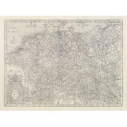
![[Title page] Germania geographicis tabulis illustrata. .](/uploads/cache/42262-250x250.jpg)
[Title page] Germania geographicis tabulis illustrata. .
Very rare and beautiful title page from the second edition of Cornelis de Jode rare atlas. In lower part a map of Germany, Poland and the Low Countries.
Date: Antwerp, 1593
Selling price: ????
Please login to see price!
Sold
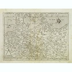
Saxonum regionis quatenus eius gentis imperium nomenquqe olim patebat, recens germanaque delineatio. . .
Map of north east Germany with part of Poland. Like all de Jode maps: scarce and much sought after.
Date: Antwerp, 1593
Selling price: ????
Please login to see price!
Sold in 2012
Sueviae.
Very rare and beautifully engraved map from De Jode's atlas Speculum Orbis Terrarum . Detailed map of region of Ulm, Strasbourg, Bodensee.Engraved by Joan and Lucas van D...
Date: Antwerp 1593
Selling price: ????
Please login to see price!
Sold
Hessiae seu cattorum noblissimorum ac Bellicosissimorum ..
Very rare and beautifully engraved map from De Jode's atlas Speculum Orbis Terrarum . Detailed map of the regions east and west of the river Fulga.Engraved by Joan van Do...
Date: Antwerp 1593
Selling price: ????
Please login to see price!
Sold
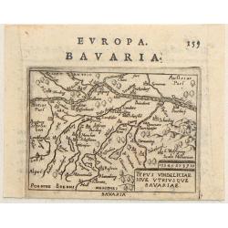
Typus Vindeliciae Sive Utriusque Bavariae.
Charming miniature map of Danube River as it passes through Bavaria. It is from Philip Galle's 1593 Italian edition of the Epitome. Simple title cartouche.
Date: Rome, 1593
Selling price: ????
Please login to see price!
Sold in 2017
Sueviae utriusq cum Germaniae tum Rhetiae. . .
Very rare and beautifully engraved map from De Jode's atlas Speculum Orbis Terrarum . Detailed map of region of Ulm, Strasbourg, Bodensee.Engraved by Joan and Lucas van D...
Date: Antwerp, 1593
Selling price: ????
Please login to see price!
Sold in 2013
Holsatia Ducatus.
A detailed map of the Schleswig-Holstein area of Germany extending south to include Hamburg and Lubeck. From the first edition of Mercator's Atlas. Latin text verso
Date: Duisberg, 1595
Selling price: ????
Please login to see price!
Sold in 2014
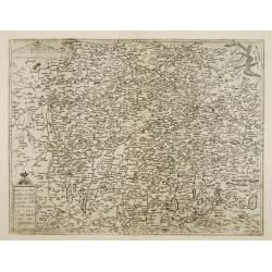
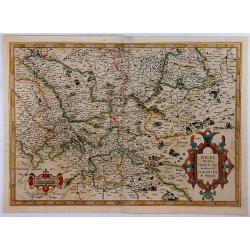
Turingiae Noviss. Descript. / Misniae et Lusatiae Tabula.
A delightful pair of central German maps of Thuringia & Meissen, by Ortelius, published in Antwerp towards the end of the sixteenth century. The left hand map is that...
Date: Antwerp, ca 1595
Selling price: ????
Please login to see price!
Sold in 2020
Berghe Ducatus Marck comitatus et Coloniensis Dioecisis.
A rare first edition of Mercator's detailed map of Germany, from the first addition (1595) of Mercator's atla, “Atlas Sive Cosmographia”. The map covers a large secti...
Date: Amsterdam, 1595
Selling price: ????
Please login to see price!
Sold in 2018
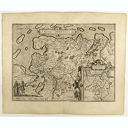
Frisia Orientalis.
Includes the provinces of Friesland. The map was prepared by Jan Bloemmaerts. Dare to go in Black. All early maps were printed in black and white, and many were kept t...
Date: Antwerp, 1598
Selling price: ????
Please login to see price!
Sold in 2023
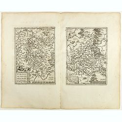
Franciae Orientalis (Vulgo Franckenlant) Descriptio, Avctore, Sebast.A. Rotenhan. (with) Monasteriensis Et Osnaburgensis Episcopatvs Descriptio Auctore Godefrido Mascop Embricense. Cum privilegio.
The map of Frankenland is prepared by Sebastian Rotenhan (1478-1532) and showing the area between Frankfurt and Bamberg. To the right a map Monasteriensis which is after ...
Date: Antwerp, 1598
Selling price: ????
Please login to see price!
Sold in 2018
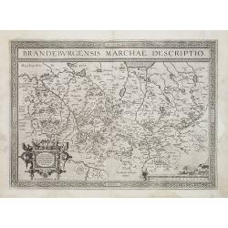
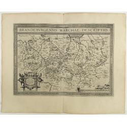
Brandeburgensis Marchiae Descriptio.
A very fine map centered on the towns of Brandenburg and Berlin. Nice title cartouche on the lower left corner.Prepared by Elias Camerius. Abraham Ortelius (1527-1598) wa...
Date: Antwerp, 1598
Selling price: ????
Please login to see price!
Sold in 2011
Thietmarsiae Holsaticae . . . (together with) Rugiae . . .
Two maps on one sheet: Left a fine map of Holstein: The island of Rugia and part of Pomerania on the right hand sheet. Abraham Ortelius (1527-1598) was a cartographer and...
Date: Antwerp, 1598
Selling price: ????
Please login to see price!
Sold in 2022
Hassiae Descriptio / Holsatiae Descriptio.
Two maps on one sheet. Left hand presents the province of Hessen, centered on the city of Munich : the right part shows the province of Holstein. Very nice cartouche on t...
Date: Antwerp, 1598
Selling price: ????
Please login to see price!
Sold in 2020
Wirtenberg Ducatus . . .
Ortelius copied the map after Georg Gadner's map of 1572.Very decorative and a masterpiece in the sense of engraving and composition.Abraham Ortelius (1527-1598) was a ca...
Date: Antwerp, 1598
Selling price: ????
Please login to see price!
Sold in 2023
Westphaliae . . .
A very fine map of Westphalia prepared by Christian sGroten. A very decorative cartouche on the upper right corner.Abraham Ortelius (1527-1598) was a cartographer and pub...
Date: Antwerp, 1598
Selling price: ????
Please login to see price!
Sold in 2022
Saxoniae Misniae Thuringiae.
A very fine map of Saxen, Misnie and Thüringen . A very decorative title cartouche on the lower left corner, and a symbolized legend cartouche on the upper right corner....
Date: Antwerp, 1598
Selling price: ????
Please login to see price!
Sold in 2020
Bavariae, olim vindeliciae delineationis..
Fine and early map of Bavaria, prepared by Philipp Apian in 1561 and used by Ortelius in his atlas 'Theatrum Orbis Terrarum [Atlas of the Whole World]. The Theatrum was r...
Date: Antwerp, 1598
Selling price: ????
Please login to see price!
Sold in 2018
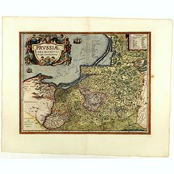
Prussiae descriptio. . .
Fine map of Ortelius' first map of Prussia, with a striking cartouche and two sailing ships, showing part of present day Poland.The map was prepared by Caspar Henneberger...
Date: Antwerp, 1598
Selling price: ????
Please login to see price!
Sold in 2018
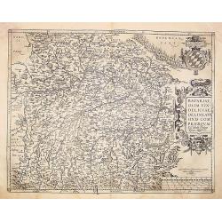
Bavariae, olim vindeliciae delineationis..
Fine and early map of Bavaria, prepared by Philipp Apian in 1561 and used by Ortelius in his atlas 'Theatrum Orbis Terrarum [Atlas of the Whole World].The Theatrum was re...
Date: Antwerp 1598
Selling price: ????
Please login to see price!
Sold
Turingiae Noviss../ Mansfeldiae Comitatus.
Two maps on one sheet. Left hand presents the province of Thüringen and is centered on the city of Erfurt. Nice cartouche on the lower left corner with a credit to the a...
Date: Antwerp, 1598
Selling price: ????
Please login to see price!
Sold in 2020
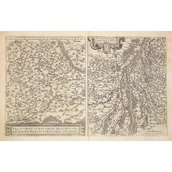
1) Palatinatvs Bavariae .. 2) Argentoratensis agri ..
From 'Theatrum Orbis Terrarum [Atlas of the Whole World]. The left hand map of Bavaria is after Erhart Reych's 4-sheet map of 1540. Including the towns of Regensburg, Nur...
Date: Antwerp, 1598
Selling price: ????
Please login to see price!
Sold in 2016
Wirtenberg Ducatus.
Ortelius copied the map after Georg Gadner's map of 1572.Very decorative and a masterpiece in the sense of engraving and composition.
Date: Antwerp, 1598
Selling price: ????
Please login to see price!
Sold in 2016
Brandeburgensis Marchiae Descriptio.
A very fine map centered on the towns of Brandenburg and Berlin. Nice title cartouche on the lower left corner.Prepared by Elias Camerius. Abraham Ortelius (1527-1598) wa...
Date: Antwerp, 1598
Selling price: ????
Please login to see price!
Sold in 2018
Mansfeldiae Comitatus Descriptioauctore Tilemanno Stella Sig.
Map of the region surrounding the town of Mansfeld (Mansfelt) in central Germany. The manuscript map drawn by Tilemann Stella. Mansfeld is the town that Martin Luther gre...
Date: Antwerp, c. 1600
Selling price: ????
Please login to see price!
Sold in 2010
Thietmarsiae Holsaticaereg.
Petrus Bertius (1565- Paris,1629), Dutch cartographer and engraver. Pocket atlas ' Tabularum geographicarum contractarum', 1600-16, ' Totius orbis Terrarum', 1626. Worked...
Date: Amsterdam, c. 1600
Selling price: ????
Please login to see price!
Sold
" Mürs Comitatus."
"Detailed and early map centred on Moers, Duisburg and Xanten. With two insets: ""Mürs Oppidum et Arx"" and ""Modiliana"&...
Date: Amsterdam 1602
Selling price: ????
Please login to see price!
Sold
Trier & Lutzenburg
Map with great original color of areas surrounding the city of Trier, the oldest city in Germany, and Lutzenberg region in northern Switzerland from the Mercator-Hodius a...
Date: Amsterdam, 1606
Selling price: ????
Please login to see price!
Sold in 2010
Holsatia ducatus.
Map of Holsatia. Including the town of Hamburg.Mercator was born in Rupelmonde in Flanders and studied in Louvain under Gemma Frisius, Dutch writer, astronomer and mathem...
Date: Amsterdam 1606
Selling price: ????
Please login to see price!
Sold
Franckenlandt Francia Orientalis.
Map centred on Alsace-Lorraine.Mercator was born in Rupelmonde in Flanders and studied in Louvain under Gemma Frisius, Dutch writer, astronomer and mathematician. The exc...
Date: Amsterdam 1606
Selling price: ????
Please login to see price!
Sold
Westfalia Cum Dioecesi Bremensi.
Map of north western part of Germany. Including the towns of Emden, Bremen, etc and the river Elbe. Decorative title cartouche in the upper left-hand corner.Mercator was ...
Date: Amsterdam 1606
Selling price: ????
Please login to see price!
Sold
![Germania. [Set of 15 maps]](/uploads/cache/43325-250x250.jpg)
Germania. [Set of 15 maps]
A lovely miniature set of maps of Germany, as published by Petrus Bertius, in Amsterdam at the beginning of the seventeenth century. The maps have various strap-work titl...
Date: Amsterdam, 1606
Selling price: ????
Please login to see price!
Sold in 2019
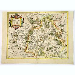
Waldeck Comitatus.
An early regional map by Mercator, centered on the central German towns of Waldeck and Korbach, etc. The map highlights major towns and cities, some highlighted in red, r...
Date: Amsterdam, 1606
Selling price: ????
Please login to see price!
Sold in 2021
Berghe Ducatus Marck Comitatus et Colonien..
Map of the province of Westphalia. Including the River Rhine and the towns of Cologne, Coblenz and Frankfurt. Title cartouche in the lower right-hand corner. With hand-wr...
Date: Amsterdam 1606
Selling price: ????
Please login to see price!
Sold
Murs Comitatus.
Two maps on one sheet: left hand map showing part of the Netherlands with rivers Rhine and Maas. The right hand map the river Rhine from Zanten till Münchengladbach, wit...
Date: Amsterdam 1606
Selling price: ????
Please login to see price!
Sold
Saxoniae Superioris Lusatiae Misniaeque. . .
Map depicting part of Saxony and is centered on the towns of Dresden and Meissen.Mercator was born in Rupelmonde in Flanders and studied in Louvain under Gemma Frisius, D...
Date: Amsterdam, 1606
Selling price: ????
Please login to see price!
Sold in 2020
Murs Comitatus.
Two maps on one sheet: left hand map showing part of the Netherlands with rivers Rhine and Maas. The right hand map the river Rhine from Zanten till Monchengladbach, with...
Date: Amsterdam, 1606
Selling price: ????
Please login to see price!
Sold
Germania.
Map of Germany by G. Mercator who was born in Rupelmonde in Flanders and studied in Louvain under Gemma Frisius, Dutch writer, astronomer and mathematician.The excellence...
Date: Amsterdam, 1606
Selling price: ????
Please login to see price!
Sold
Hassia Landgraviatus.
A copper engraved map from Mercator's "Atlas Minor", published in 1607. Showing the Hesse-Kassel region centred on Kessel, Germany with the course of the Fulda...
Date: Amsterdam, 1607
Selling price: ????
Please login to see price!
Sold in 2020
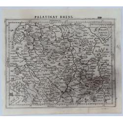
Palatinat Rhen.
A copper engraved map from Mercator's "Atlas Minor", published in 1607. The County Palatine of the Rhine in Germany was later the Electorate of .... Bavarian el...
Date: Amsterdam, 1607
Selling price: ????
Please login to see price!
Sold in 2020
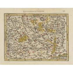
Westphaliae tabula II.
Richly detailed map centered on North Rhine-Westphalia. From the first French-text edition of Jodocus Hondius' Atlas Minor.Shortly after the publication of the big folio-...
Date: Amsterdam, 1608
Selling price: ????
Please login to see price!
Sold in 2022
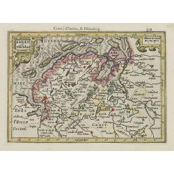
Emden et Oldenbor.
Detailed map of the Northern part of Germany with Emden and Bremen. Nice engraved forests and hundreds of tiny villages.From the first French-text edition of Jodocus Hond...
Date: Amsterdam, 1608
Selling price: ????
Please login to see price!
Sold in 2010
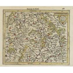
Palatinatus Rheni.
Detailed map showing part of Rhineland-Palatinate. With Ulm, Frankfort, Heidelberg and other major cities of the surrounding area named.From the first French-text edition...
Date: Amsterdam, 1608
Selling price: ????
Please login to see price!
Sold in 2020
Holsatia.
Map of Holsatia, including the town of Hamburg. From the first French-text edition of Jodocus Hondius' Atlas Minor.Shortly after the publication of the big folio-atlases ...
Date: Amsterdam, 1608
Selling price: ????
Please login to see price!
Sold in 2017
Cleve et Murs.
Map of Cleve, including Eindhoven, Dusseldorf, Aachen, Maastricht, etc. From the first French-text edition of Jodocus Hondius' Atlas Minor.Shortly after the publication o...
Date: Amsterdam, 1608
Selling price: ????
Please login to see price!
Sold in 2019
Thuringia.
Detailed map showing the region around Erfurt and Weimar. With major cities of the area named.From the first French-text edition of Jodocus Hondius' Atlas Minor.Shortly a...
Date: Amsterdam, 1608
Selling price: ????
Please login to see price!
Sold in 2020
Westphaliae tabula tertia.
Richly detailed map showing part of western Germany between Cologne, Frankfurt and Kassel.From the first French-text edition of Jodocus Hondius' Atlas Minor.Shortly after...
Date: Amsterdam, 1608
Selling price: ????
Please login to see price!
Sold in 2022
