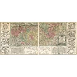
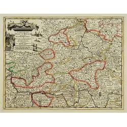
Charte Geographique de la Campagne du Haut Rhin...
Large map by J.F. Oettinger on 2 sheets.
Date: Augsburg, 1740.
Selling price: ????
Please login to see price!
Sold in 2009
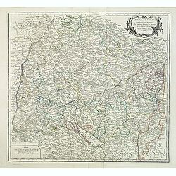
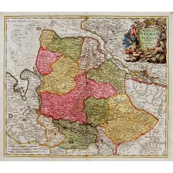
Cercle de Souabe. . .
Finely and crisply engraved map of south part of Germany. Ornamental title cartouche in the upper part of map from his "Atlas Universel".Gilles Robert de Vaugon...
Date: Paris, 1751.
Selling price: ????
Please login to see price!
Sold in 2015
Partie Septentrionale du Cercle d'Autriche...
Map showing the postal routes in The Netherlands, Belgium, France, Poland, Austria, Switzerland and Northern Italy. With an ornamental cartouche.
Date: Paris, 1752.
Selling price: ????
Please login to see price!
Sold
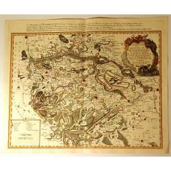
Carte Particuliere de la Principaute de Halberstadt
Carte Particuliere de la Principaute de Halberstadt. A large and rare map of Halberstadt, Germany, and its surroundings by Le Rouge. Showing the town in the German state...
Date: Paris, 17576
Selling price: ????
Please login to see price!
Sold in 2015
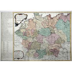
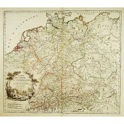
La ALEMANIA dividida en sus principales Estados segun las ultimas y nuevas observationes de las Accademias y de Paris y de Londres.
A beautiful, rare colored map of Germany by the Spanish cartographer Pedro Gendron. As in most 18th century maps published in Spain, which are based upon non-Spanish sour...
Date: Madrid(?), ca 1760
Selling price: ????
Please login to see price!
Sold in 2020
Lot of 3 maps of Germany.
Robert de Vaugondy: Empire d'Allemagne, 24 cm x 28 cm. Van der AA : Cercle du Haut Rhin, 22,5cm x 29 cm: L'Allemagne, 22,5 cm x 29 cm.The three maps are well-engraved.
Date: Paris/ Leiden
Selling price: ????
Please login to see price!
Sold
Ducatus Bremae et Ferdae nova tabula.
A very decorative and detailed map with Hamburg on the river Elbe. Also including Oldenburg and Bremen. With a very decorative title cartouche showing putti and allegoric...
Date: Nuremberg, 18th century
Selling price: ????
Please login to see price!
Sold
