Browse Listings in Europe > Eastern Europe
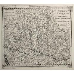
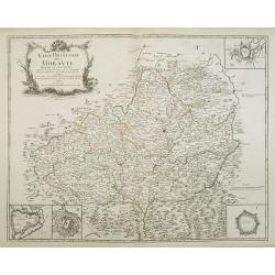
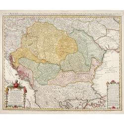
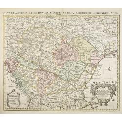
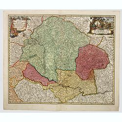
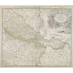
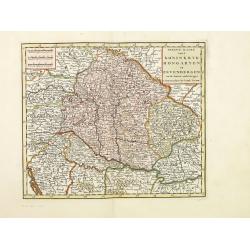
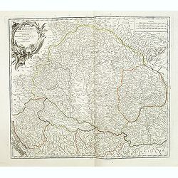
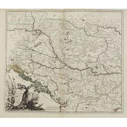
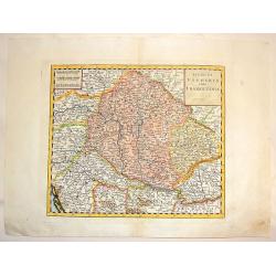
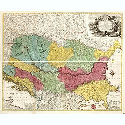
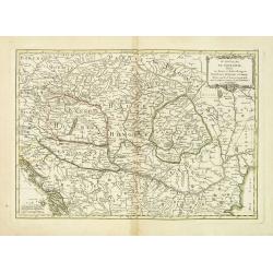
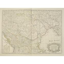
Nuovo Carta del Regno di Ungheria, e della Transilvania ...
Detailed map of Hungary, Slovenia, Transylvania, and parts of Croatia, Bosnia, Serbia, Romania and Bulgaria, from an Italian edition of Thomas Salmon's , “Modern Histor...
Date: Venice, 1740
Selling price: ????
Please login to see price!
Sold in 2019
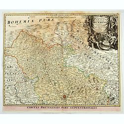
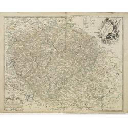
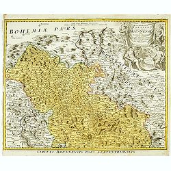
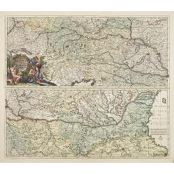
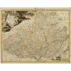
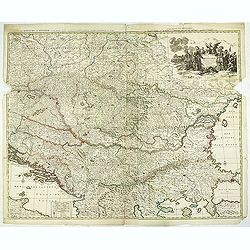
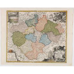
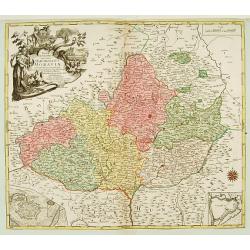
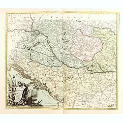
Marchionatus Moraviae circulus brunnensis. . .
Johann Baptist Homann's well-engraved map has a large decorative cartouche. Detailed map centered on Bruenn in Moravia. Prepared by Johann Chr. Mueller. Very decorative t...
Date: Nuremberg, 1740
Selling price: ????
Please login to see price!
Sold in 2020
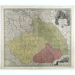
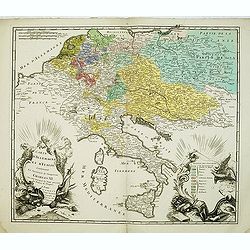
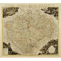
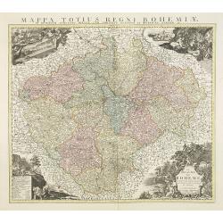
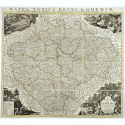
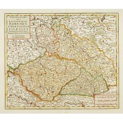
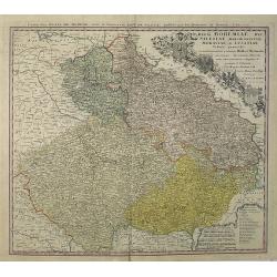
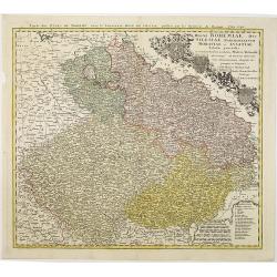
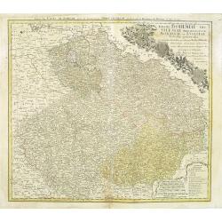
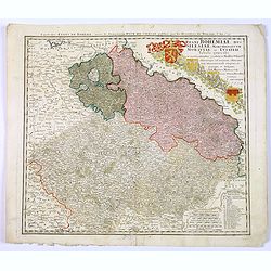
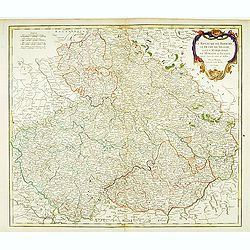
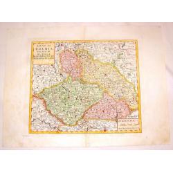
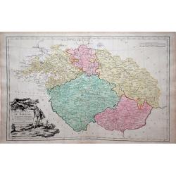
Mappa Geographica Regnum Bohemiae Cum Adiunctis Ducatu Silesiae, . . .
Map of part of Germany, Czech Republic and Poland, with engraved detailed hand colored map. Includes decorative cartouche. Shows cities and towns, place names, rivers, fo...
Date: Augsbourg, 1741
Selling price: ????
Please login to see price!
Sold in 2018
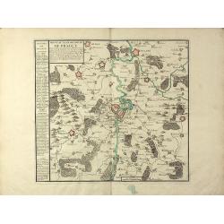
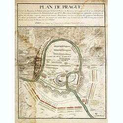
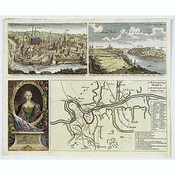
Nouveau Plan de la Ville de Prague Et de ses Environs, Capiltale de Bohème
A rare separately issued battle plan of Prague by Baillieul and Jombert. Showing the Siege of Prague in 1742 with deployment of troops. With one mileage scale, text carto...
Date: Paris, 1742
Selling price: ????
Please login to see price!
Sold in 2011
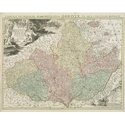
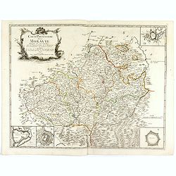
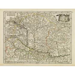
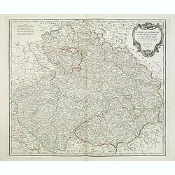
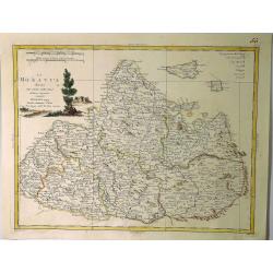
Carte Particuliere de la Moravie Divisée en six Cercles . . .
Detailed map of former Czechoslovakia now part of the province of Moravia and Silesia. From the original survey by Mr. Muller with inset plans of Olmutz, Iglaw, Neustatt ...
Date: Paris, 1742
Selling price: ????
Please login to see price!
Sold in 2023
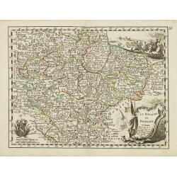
Le Royaume de Boheme. Carte reduite sur celle de 25 feuilles faite a Prague, par Müller, a Paris. Par et chez le sieur leRouge Ingr. Géographe du Roy . . .
Uncommon general map of the Czech Republic, centered on Prague. Prepared after the 25 sheet wall map of Muller, and published by Le Rouge. Folio maps by Le Rouge are quit...
Date: Paris, 1742
Selling price: ????
Please login to see price!
Sold in 2010
Carte D'Allemagne Et D'Italie Contenant La Succession de l'Empereur Charles VI. Ou sont marqués les Etats presents des Princes de l'Empire
Uncommon map showing the territories after the reign of Charles VI, who was emperor of the Holy Roman Empire, which he ruled from 1711 until 1740). Charles VI's was fathe...
Date: Paris, 1742
Selling price: ????
Please login to see price!
Sold in 2012
Plan de Prague.
Rare and separately published plan of Prague published by Joan Baptista Nolin with the address à l'enseigne de la Place des Victoires et chez le Sr. Humblot rue St. Jaqu...
Date: Paris, ca. 1742
Selling price: ????
Please login to see price!
Sold in 2012
A Plan of the City of Prague, with the French and Austrian Camps.
An interesting plan showing the Battle of Prague (1742) with a pair of attractive birds-eye views of Prague and Egra, plus an engraving of the Queen of Hungary, Maria Ter...
Date: London, ca 1742
Selling price: ????
Please login to see price!
Sold in 2019
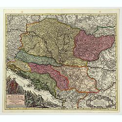
Hungariae..propriae, Croatiea, Dalmatiae, Bosniae..
Detailed map of Central Europe.
Date: Neurenberg 1744
Selling price: ????
Please login to see price!
Sold
Marchionatus Moraviae circulus brunnensis..
Johann Baptist Homann's well-engraved map has a large decorative cartouche. Detailed map centered on Brunnensis, showing the main cities. Very decorative title cartouche ...
Date: Nuremberg, 1744
Selling price: ????
Please login to see price!
Sold in 2008
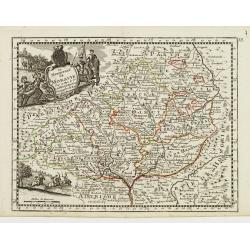
Le Royaume de Boheme Divisée en ses douze Cercles.
Highly detailed copper-engraved map of Bohemia centered on Prague. Ornated with decorative cartouches at the 4 corners of the map representing respectively a view of Prag...
Date: Amsterdam c. 1744
Selling price: ????
Please login to see price!
Sold
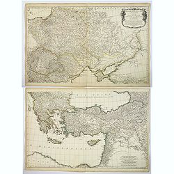
![[2 maps] Theatre de la Guerre Dans la Petite Tartarie, La Crimee, la Mer Noire, &c.. [and] Seconde Partie de la Crimée.. (2 maps)](/uploads/cache/21474-250x250.jpg)
[2 maps] Theatre de la Guerre Dans la Petite Tartarie, La Crimee, la Mer Noire, &c.. [and] Seconde Partie de la Crimée.. (2 maps)
Set of 2 copper engraved maps from the observations of Guillaume Delisle focusing on the Black Sea with wonderful detail of the surrounding regions. Includes Constantinop...
Date: Amsterdam c. 1744
Selling price: ????
Please login to see price!
Sold
Le Royaume de Boheme Divisée en ses douze Cercles.
Highly detailed copper-engraved map of Bohemia centered on Prague. Ornated with decorative cartouches at the 4 corners of the map representing respectively a view of Prag...
Date: Amsterdam, c. 1744
Selling price: ????
Please login to see price!
Sold in 2009
Carte Générale du Marquisat de Moravie Divisée en six Cercles dressée sur les mémoires les plus nouveaux.
Detailed copper-engraved map representing Moravia divided in districts. With decorative title cartouche and legend cartouche on upper left and lower right corners. Shows ...
Date: Amsterdam, c. 1744
Selling price: ????
Please login to see price!
Sold in 2009
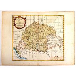
Le Royaume de Hongrie et des pays qui en dependoient autrefois..
Detailed copper-engraved map of Hungary with its neighboring countries. The map is also improved after the observations by Marsigli, who published an important descriptio...
Date: Amsterdam, c. 1744
Selling price: ????
Please login to see price!
Sold in 2012
Exactissima Totius DANUBII FLUVII. Tabula et . . .
Two maps on one sheet, showing the course of the River Donau. Originally published by Danckerts. The upper part has a nice originally colored title cartouche and depicts ...
Date: Amsterdam, c. 1744
Selling price: ????
Please login to see price!
Sold in 2009
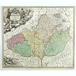
Carte particulière de la Moravie Divisée en six Cercles avec les Principaux Postes de ce Marquisat, pour l'intelligence de la Guerre présente . . .
Fine map of Moravia which occupies most of the eastern part of the Czech Republic, including the South Moravian Region, the Zlín Region, vast majority of the Olomouc Reg...
Date: Paris, 1744
Selling price: ????
Please login to see price!
Sold in 2016
Le royaume de Boheme divisée en ses douzes cercles. . .
Highly detailed copper-engraved map of Bohemia centered on Prague, which is a reduced version of the 25 sheets map by Johann Christoph Müller (1673-1721).Ornated with de...
Date: Amsterdam, ca. 1744
Selling price: ????
Please login to see price!
Sold in 2017
Tabula Generalis Marchionatus Moraviae..
Johann Baptist Homann's well-engraved map has a large decorative cartouche. Detailed map of the present-day Jihormoravsky region centred on Brno.Johann Baptist Homann (16...
Date: Nuremberg 1744
Selling price: ????
Please login to see price!
Sold in 2018
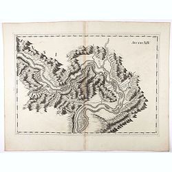
Sectio XIV.
Map of part of the Danube showing section in Romania. Prepared by Count Luigi Ferdinando Marsili (1658 - 1730) who was an Italian scholar and eminent natural scientist. P...
Date: Amsterdam, 1744
Selling price: ????
Please login to see price!
Sold in 2020
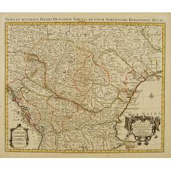
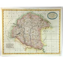
Regni Hungariae tabula generalis. . .
Johann Baptist Homann's well-engraved map of Hungary. With a fine decorative title cartouche and another hunting cartouche in the opposite corner housing the mileage scal...
Date: Neurenberg, 1744
Selling price: ????
Please login to see price!
Sold in 2023
Regnorum Hungariae, Dalmatiae, Croatiae. . .
Johann Baptist Homann's well-engraved map of Hungary. With a fine decorative title cartouche showing the Hapsburg victors of war and the vanquihsed Ottomans in equal meas...
Date: Nuremberg, 1744
Selling price: ????
Please login to see price!
Sold in 2022
Carte Générale du Marquisat de Moravie Divisée en six Cercles
Detailed copper-engraved map representing Moravia divided in districts. With decorative title cartouche and legend cartouche on upper left and lower right corners. Shows ...
Date: Amsterdam c. 1745
Selling price: ????
Please login to see price!
Sold
Le Royaume de Hongrie et des pays qui en dependoient autrefois..
Detailed copper-engraved map of Hungary with its neighbouring countries. The map is also improved after the observations by Marsigli, who published an important descripti...
Date: Amsterdam c. 1745
Selling price: ????
Please login to see price!
Sold
Tabula geographica exhibens regnum Sclavoniae. . .
Detailed copper-engraved map of Slavonia, the region in eastern Croatia. Belgrade to the east with the Danube, with the Sava a right side tributary of the Danube river.Ma...
Date: Nuremberg, 1745
Selling price: ????
Please login to see price!
Sold in 2011
Théatre de la Guerre en Hongarie, Transilvanie &c
Large, four sheet detailed map of Hungary.
Date: Amsterdam c. 1745
Selling price: ????
Please login to see price!
Sold in 2012
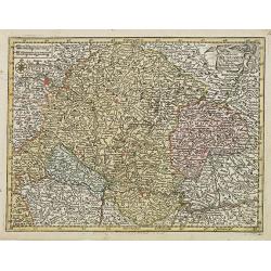
..Bohemen tHertogdom Silesien..Moravien en Lusatien.
Detailed map of Czech Republic. Including the towns of Berlin, Vienna, Regensburg. Isaac Tirion was born in Utrecht ca. 1705. He came to Amsterdam ca. 1725. Tirion publis...
Date: Amsterdam, 1747
Selling price: ????
Please login to see price!
Sold in 2015
Regni Bohemiae, Duc. Silesiae, Marchionatuum Moraviae et Lusatiae. . .
Johann Baptist Homann's well-engraved map including the towns of Prague, Poznan/ Loda, Wroclaw, etc.Johann Baptist Homann (1663-1724) was a German engraver and publisher,...
Date: Nuremberg, 1748
Selling price: ????
Please login to see price!
Sold in 2013
Regni Bohemiae, Duc. Silesiae, Marchionatuum Moraviae et Lusatiae. . .
Johann Baptist Homann's well-engraved map including the towns of Prague, Poznan/ Loda, Wroclaw, etc.Johann Baptist Homann (1663-1724) was a German engraver and publisher,...
Date: Nuremberg, 1748
Selling price: ????
Please login to see price!
Sold in 2010
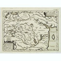
Moldaviae, finitimar umo regionum typus.
Uncommon map of Moldavia published in the second edition of Martinus Broniovius "Tartariae description ..." His work appeared first in 1595. The second edition ...
Date: Vienna, 1746-1748
Selling price: ????
Please login to see price!
Sold in 2012
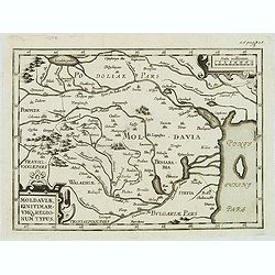
Moldaviae, finitimar umo regionum typus.
Uncommon map of Moldavia published in the second edition of Martinus Broniovius "Tartariae description ..." His work appeared first in 1595. The second edition ...
Date: Vienna, 1746-1748
Selling price: ????
Please login to see price!
Sold
Regni Bohemiae, Duc. Silesiae, Marchionatuum Moraviae et Lusatiae. . .
Johann Baptist Homann's well-engraved map including the towns of Prague, Poznan/ Loda, Wroclaw, etc.This example was printed from plate B (2nd of 3), which can be identif...
Date: Nuremberg, 1748
Selling price: ????
Please login to see price!
Sold in 2018
Regni Bohemiae, Duc. Silesiae, Marchionatuum Moraviae et Lusatiae. . .
Johann Baptist Homann's well-engraved map including the towns of Prague, Poznan/ Loda, Wroclaw, etc.Johann Baptist Homann (1663-1724) was a German engraver and publisher,...
Date: Nuremberg, 1748
Selling price: ????
Please login to see price!
Sold in 2018
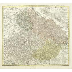
Regni Bohemiae, Duc. Silesiae, Marchionatuum Moraviae et Lusatiae. . .
Johann Baptist Homann's well-engraved map including the towns of Prague, Poznan/ Loda, Wroclaw, etc.Johann Baptist Homann (1663-1724) was a German engraver and publisher,...
Date: Nuremberg, 1748
Selling price: ????
Please login to see price!
Sold in 2020
Reise Charte durch das Konigreich Bohmen Hertzogthum Schlesien.
A hand colored map showing the region which is now southern Poland and the Czech Republic with the cities of Prague, Olmutz (Olomouc), and Breslaw (Wroclaw). Includes exp...
Date: Leipzeg, 1749
Selling price: ????
Please login to see price!
Sold in 2018
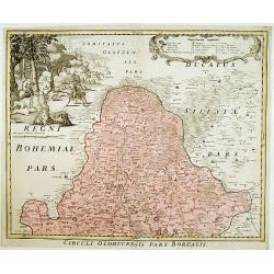
Circuli Olomucensis pars Borealis.
Beautiful decorative cartouche upper right with the legend and very beautiful figurative scene upper left corner.
Date: Nurimberg, c.1750
Selling price: ????
Please login to see price!
Sold
Nieuwe kaart van.. Hongaryen en Sevenbergen. . .
Detailed map of Hungary in attractive full original colors. Isaak Tirion was born in Utrecht ca. 1705. He came to Amsterdam ca. 1725. Tirion published a number of importa...
Date: Amsterdam, 1750
Selling price: ????
Please login to see price!
Sold in 2023
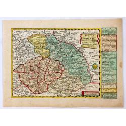
Mappa Geographica Totius Regni Bohemiae In XII Circulos divisae annexisComitatuGlacensi et Districtu Egerano . . .
Uncommon map of the Czech Republic, centered on Prague. Includes four ornate cartouches, coat of arms and a birdseye view of the Bridge across the Moldau River in Prague.
Date: Augsburg, 1750
Selling price: ????
Please login to see price!
Sold in 2020
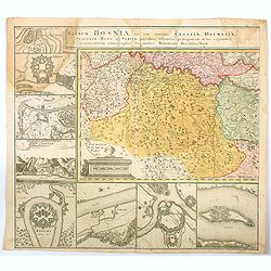
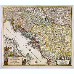
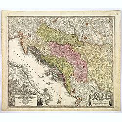
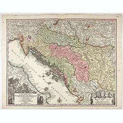
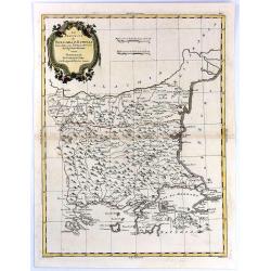
Regnum Bosniae , una cum finitimis Croatiae, Dalmatiae. . .
One half of a large two sheet map that covers from the Dalmatian coast to Walachia to the city of Nissa, including Bosnia, Serbia, Croatia, and parts of Slovenia and Bulg...
Date: Nuremberg, ca 1750
Selling price: ????
Please login to see price!
Sold in 2020
Le royaume de Boheme, le Duché de Silésie..
Covering Czech Republic, embellished with decorative title cartouche.
Date: Paris, 1751
Selling price: ????
Please login to see price!
Sold in 2008
Le Royaume de Hongrie.
Detailed map of Hungary. Including kingdom of Croatia, Bosnia, Serbia and Bulgaria from his "Atlas Universel".Gilles Robert de Vaugondy (1688–1766), also know...
Date: Paris, 1751
Selling price: ????
Please login to see price!
Sold in 2020
Le Royaume de Boheme.
Fine map of Bohemia, with title cartouche and two decorative cartouches on upper right and lower left corners. George Louis Le Rouge was active from 1740- till 1780 as a ...
Date: Paris 1756
Selling price: ????
Please login to see price!
Sold
Le Royaume de Hongrie.
Fine map of Hungary, with title cartouche. With title cartouche and decorative cartouche on upper right corner. George Louis Le Rouge was active from 1740- till 1780 as a...
Date: Paris 1756
Selling price: ????
Please login to see price!
Sold
Le Marquisat de Moravie.
Fine map of Moravia, with decorative title cartouche and another cartouche on lower left corner. George Louis Le Rouge was active from 1740- till 1780 as a publisher, and...
Date: Paris 1756
Selling price: ????
Please login to see price!
Sold
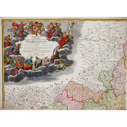
Le Royaume de Hongrie la Transilvanie L'Esclavonie la Croatie et la Bosnie.
Fine map of Hungary with a splendid cartouche of an elephant, a crocodile and a canon and canon balls in the forefront and an array of flags amidst a cloud of smoke in th...
Date: Paris, 1756
Selling price: ????
Please login to see price!
Sold in 2013
MAPPA GEOGRAPHICA SPECIALIS MARCHIONATUS MORAVIAE IN SEX CIRCULOS DIVISAE?
Map depicting the South/East part of Czech republic, showing Brno and Olomouc and two insets of these cities lower corners.
Date: Augsburg, 1758
Selling price: ????
Please login to see price!
Sold
![Plan de Prag. [Manuscript plan of Prague - Praha]](/uploads/cache/24911-250x250.jpg)
Plan de Prag. [Manuscript plan of Prague - Praha]
Very nice manuscript plan of Prague and the castle. Not dated or signed. In upper left a numbered key 1-36 referring to the ramparts of the town and a scale (of 1:700 aul...
Date: [France] ca. 1760
Selling price: ????
Please login to see price!
Sold
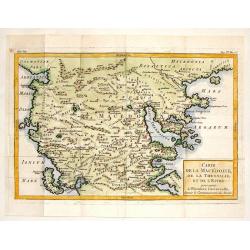
Carte de la Macedoine, de la Thessalie et de L'Epire.
Interesting copper engraved map of the Balkan region including what is currently Macedonia, Albania and northern Greece. Block style title cartouche. Jacques Nicolas Bel...
Date: Paris, 1760
Selling price: ????
Please login to see price!
Sold in 2013
Nova et accurata.. Dalmatiae, Croatiae, Sclovoniae, Bosniae. . .
A finely engraved and large detailed map including the western part of the river Donau. Two decorative cartouches adorn the lower corners of the map. One with coats of ar...
Date: Augsburg, 1760
Selling price: ????
Please login to see price!
Sold in 2017
Troisieme partie de la Carte d'Europe conenant ..Russie, Pologne et la Hongrie, la Turquie. . .
A large 2 sheet map, by French cartographer d'Anville, measuring 1030 x 1620 mm when joined together, showing most of Eastern Europe, parts western Russia and parts of th...
Date: Paris, ca. 1760
Selling price: ????
Please login to see price!
Sold in 2017
Nova et accurata.. Dalmatiae, Croatiae, Sclovoniae, Bosniae. . .
A finely engraved, large detailed map that includes the western part of the river Donau. Two decorative cartouches adorn the lower corners of the map. One of these shows ...
Date: Augsburg, 1760
Selling price: ????
Please login to see price!
Sold in 2018
Hungary.
A map of mid eighteenth century copperplate map of Hungary, with a decorative title cartouche. Bordered by Poland, Slavonia, Turkey, Moldova and Romania. Map is split int...
Date: London, ca 1760
Selling price: ????
Please login to see price!
Sold in 2020
Nova et accurata.. Dalmatiae, Croatiae, Sclovoniae, Bosniae. . .
A finely engraved and large detailed map including the western part of the river Donau. Two decorative cartouches adorn the lower corners of the map. One with coats of ar...
Date: Augsburg, 1760
Selling price: ????
Please login to see price!
Sold in 2023
Regno di Ungheria e della Transilvania.
Fine copper-engraved map featuring Hungary and Transylvania (Romania). Embellished with block title & scale cartouches.Giambattista Albrizzi (1698-1777) was a Venetia...
Date: venice, 1740-1762
Selling price: ????
Please login to see price!
Sold in 2016
Regno di Boemia Ducato di Slesia, Marchesato de moravia, c Lusazia.
Fine copper engraved map os Czechoslovachia, Poland and Hungary. Two block type cartouches.Giambattista Albrizzi (1698-1777) was a Venetian publisher and journalist. Amo...
Date: Venice from 1740-1762
Selling price: ????
Please login to see price!
Sold in 2016
La Hongrie avec les Provinces.
Nice map of Hungary by Brion and published by Desnos. With Rococo style cartouche. Louis Brion de la Tour (1756-1823) was a geographer and demographer. His official tit...
Date: Paris, 1765
Selling price: ????
Please login to see price!
Sold in 2014
Etats de Bohême divisés..
Detailed map centered on Prague.
Date: Paris, 1766
Selling price: ????
Please login to see price!
Sold
![[No title] Carte générale d'Allemagne divisée et numérotée...des postes et autres routes de cet empire.](/uploads/cache/29260-250x250.jpg)
[No title] Carte générale d'Allemagne divisée et numérotée...des postes et autres routes de cet empire.
Map centered on Czechoslovakia, with Prague, including, Krakow, Vienna, Leipzig, etc.A so called post road mapspost route map.Desnos, born in a small village close to Bea...
Date: Paris, 1766
Selling price: ????
Please login to see price!
Sold in 2011
![[No tittle]](/uploads/cache/29446-250x250.jpg)
[No tittle]
Map of Czech Republic and Hungary.
Date: Paris, 1766
Selling price: ????
Please login to see price!
Sold in 2014
Tabula Almae Dioecesis Amplissimi Episcopatus Olomucensis.
Homann Heirs (of Johann Baptist and Johann Christof) published: Grosser Atlas, 1731, 1737. Geogr. Maior, 1759, Atlas Homannianus, 1762.An attractive, large and very detai...
Date: Nürnberg, 1767
Selling price: ????
Please login to see price!
Sold
Le Royaume De Boheme, Le Duche De Silesie, et Les Marquisats De Moravie et Lusace. . . 1751
Map of Bohemia, Silesia, Poland, Moravia and Lusatia embellished with decorative title cartouche from his "Atlas Universel".Shows Prague, Breslau, Glogau, Oppel...
Date: Paris, 1768
Selling price: ????
Please login to see price!
Sold in 2018

(Dalmatien). Lower left sheet from the famous wall map 'Mappa Geographica novissima Regni Hungariae divisi in suos Comitatus'.
Lower left sheet from the famous wall map "Mappa Geographica novissima Regni Hungariae divisi in suos Comitatus" of Hungary. This part depicting part of Dalmati...
Date: Vienna, 1769
Selling price: ????
Please login to see price!
Sold
Carte de la Moldavie dressée sur celle du prince Cantimir. . .
Extremely rare map of the north of Moldavia and the regions today in Ukraine. In top the title Moldavie Septentrionale. Another map of the southern part exists to complem...
Date: Paris, 1770
Selling price: ????
Please login to see price!
Sold in 2011
De la Pannonie, De la Liburnie, De la Dalmatie et de la Grece en General.
Fine map of what is now Croatia. By brion de la Tour and Charles Desnos in Paris in 1770. The map has much French text on either side and a very fancy border that was eng...
Date: Paris , 1770
Selling price: ????
Please login to see price!
Sold in 2017
Carte Geographique du Theatre de la Guerre en General representant le Royaume de Hongarie la Principauté de Transylvanie, et les Royaumes de Croacie, de Dalmacie, de Esclavonie, de Bosnie, de Servie . . .
Carte Geographique du Theatre de la Guerre en General representant le Royaume de Hongarie la Principauté de Transylvanie, et les Royaumes de Croacie, de Dalmacie, de Esc...
Date: Augsburg, 1771
Selling price: ????
Please login to see price!
Sold in 2021
Le Royaume de Hongrie la Transilvanie L'Esclavonie la Croatie et la Bosnie.
Fine map of Hungary, Slovakia, Romania, etc. with a splendid cartouche of an elephant, a crocodile and a canon and canon balls in the forefront and an array of flags amid...
Date: Paris, 1772
Selling price: ????
Please login to see price!
Sold in 2019
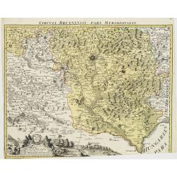
Circuli Brunnensis Pars Meridionalis.
Johann Baptist Homann's well-engraved and detailed map of the present-day South Moravia region centered on Brno, with decorative cartouche at the bottom.Johann Baptist Ho...
Date: Nuremberg 1770 - 1774
Selling price: ????
Please login to see price!
Sold in 2008
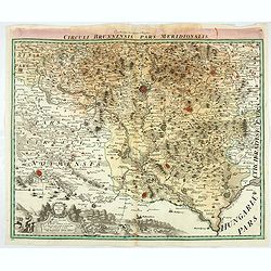
Circuli Brunnensis Pars Meridionalis.
Johann Baptist Homann's well-engraved and detailed map of the present-day South Moravia region centred on Brno, with decorative cartouche at the bottom.Johann Baptist Hom...
Date: Nuremberg 1770 - 1774
Selling price: ????
Please login to see price!
Sold in 2020
Le Royaume de Hongarie, Divisé en Haute et Basse Hongrie Transilvanie Esclavonie et Croatie. . .
Map of Hungary, part of Poland, Bosnia, Serbia, Bulgaria, prepared by Janvier. From Jean Lattré, "Atlas Moderne ou Collection de Cartes sur Toutes les Parties du Gl...
Date: Paris, 1775
Selling price: ????
Please login to see price!
Sold in 2011
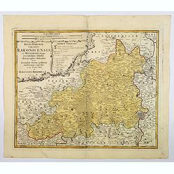
Regni Bohemiae Circulus Rakonicensis . .
A nice large-scale map of the Rakovnik region, north and west of Prague in the Czech republic. Published by Homann Heirs in the mid-eighteenth century in Nuremberg. From ...
Date: Nuremburg, 1776
Selling price: ????
Please login to see price!
Sold in 2021
Regni Hungariae. . .
Miniature map of Hungary.From Atlas Minor, here published by Johann Martin Will, with his address in bottom center of the map.The cartouche is left uncolored in order to ...
Date: Augsburg, J.M.Will, 1778
Selling price: ????
Please login to see price!
Sold in 2022
La Moravia Divisa Ne Suoi Circoli. . .
A handsome map of Moravia that is part of the present-day Czech Republic. The map is focused roughly on Wischau and is filled with details of roads, towns and pictorial t...
Date: Venice, 1779
Selling price: ????
Please login to see price!
Sold in 2021
Carte de la Hongrie et Partie Septentrionale de la Turquie. . .
Showing the region between the Gulf of Venice and Croatia to the Black Sea, including Bulgaria, Romania, Macedonia, Ukraine, Hungary, and part of Poland and Bohemia.Decor...
Date: Paris, 1780
Selling price: ????
Please login to see price!
Sold in 2023
Hungary with Part of the Adjoining Principalities &c.
A fine late 18th century copper engraved map of Hungary and Romania published in 'Barlow's General History of Europe'.Thomas Bowen was an English engraver of charts. He w...
Date: London, 1780
Selling price: ????
Please login to see price!
Sold in 2016
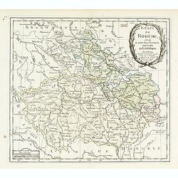
Carte des Etats de Boheme . . .
Louis Brion de la Tour map of Bohemia (Czech Republic), city of Prague is in the center of the map.
Date: Paris, 1781
Selling price: ????
Please login to see price!
Sold in 2010
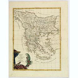
Le Provincie di Bulgaria, e Rumelia Tratte dalla carte dell' Impero Ottomano del Sig Rizzi Zanoni
A copper engraving, in delightful original outline color, featuring both Bulgaria & Romania. A decorative map by the northern Italian cartographer; Antonio Zatta, and...
Date: Venice, 1781
Selling price: ????
Please login to see price!
Sold in 2018
Turchia d'Europa divisa Nelle Sue Provincie, e Governi. . .
The pleasing map of the European provinces of the Ottoman Empire, by Antonio Zatta, published during the latter half of the eighteenth century. It shows the administrativ...
Date: Venice, 1782
Selling price: ????
Please login to see price!
Sold in 2021
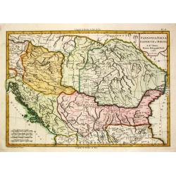
Pannonia, Dacia, Illyricum et Moesia. 1783.
Jean Lattré, Paris-based engraver and publisher. Worked with Robert de Vaugondy, J. Janvier and R. Bonne. " Atlas Monderne', 1771, 1783 , 1793. Rigobert Bonne (1727...
Date: Paris, 1783
Selling price: ????
Please login to see price!
Sold in 2018
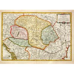
Le Royaume de Hongrie Divisé en Haute et Basse Hongrie Transylvanie Esclavonie et Croatie.
Jean Lattré, Paris-based engraver and publisher. Worked with Robert de Vaugondy, J. Janvier and R. Bonne. " Atlas Monderne', 1771, 1783 , 1793. Jean Janvier, French...
Date: Paris, 1783
Selling price: ????
Please login to see price!
Sold in 2010
