Browse Listings in Europe > Eastern Europe > Romania
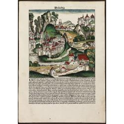
Walachia
Decorative colored incunable leaf in folio showing an imaginary view of Walachia (Romania) by Hartmann Schedel. From the famous Liber chronicarum or Nuremberg Chronicle i...
Date: Nuremberg, 1493
Selling price: ????
Please login to see price!
Sold in 2013
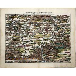
![Die Siebenbürg. . .Transylvania,Romania]](/uploads/cache/85024-250x250.jpg)
Die Siebenbürg. . .Transylvania,Romania]
Münsters first map [of 2] of Bohemia, published in Basel, circa 1550. An early woodcut map of Transylvania, Romania by Sebastian Münster oriented to the North. The titl...
Date: Basel, ca 1550
Selling price: ????
Please login to see price!
Sold in 2021
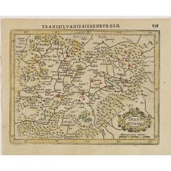
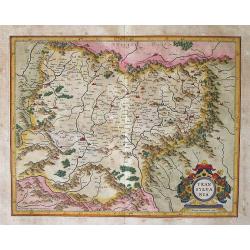
Transilvania.
A beautifully colored map of the "Seven Cities" also known as 'Transsylvania', today western Romania.
Date: Basle, 1550
Selling price: ????
Please login to see price!
Sold in 2021
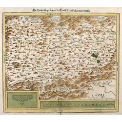
Die Siebenburg, so man sunst auch Transsylvaniam nennt
Early, attractive colored woodcut map showing Transylvania today part of Romania. From a German edition of Cosmographia from Sebastian Munster.
Date: Basle, 1550
Selling price: ????
Please login to see price!
Sold in 2008
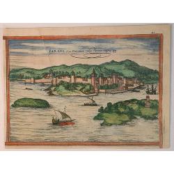
Parens, siue Parentium Vulvo Pareenzo Histrie Opp.
A woodcut from: Braun & Hogenberg's, Civitates Orbis Terrarum. It is of Parens or Parentium, commonly Porec, town in Istria. COMMENTARY BY BRAUN: "Porec is a to...
Date: Cologne, 1575
Selling price: ????
Please login to see price!
Sold in 2020
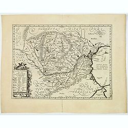
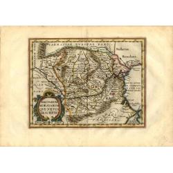
Vetus Descriptio Daciarum Nec non Moesiarum.
Decorative map of Romania, Signed lower part : Petrus Kaerius Caelavit. No text on verso. Extremely rare early or proof state of Jan Jansson's map of Romania, pre-dating ...
Date: Antwerp, 1595
Selling price: ????
Please login to see price!
Sold in 2018
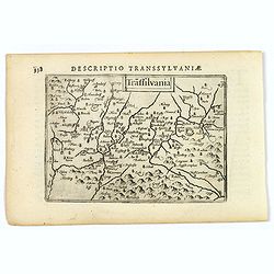
Transilvania.
A really attractive miniature map of the region of Transylvania is central Romania, as it was at the beginning of the seventeenth century. Published by Petrus Bertius in ...
Date: Amsterdam, 1606
Selling price: ????
Please login to see price!
Sold
Transsylvania.
Charming small map showing part of Romania, from the first French-text edition of Jodocus Hondius' Atlas Minor.Shortly after the publication of the big folio-atlases the ...
Date: Amsterdam, 1608
Selling price: ????
Please login to see price!
Sold in 2011
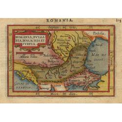
Romania, Bulgaria..
Miniature map of the Romania Turkey and Bulgaria region, with major cities named like Constantinopel. The sea is stipple engraved. Strapwork title cartouche at top. Latin...
Date: Antwerp 1609
Selling price: ????
Please login to see price!
Sold
Transylvania / Per Gerardum Mercatorem.
An early, well-prepared map by Gerard Mercator of the famed region of Transylvania in southeast Europe.Gerard Mercator (1512-1594) was one of the most famous geographers ...
Date: Druisburg and then Amsterdam, (1595) 1613
Selling price: ????
Please login to see price!
Sold in 2012
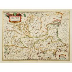
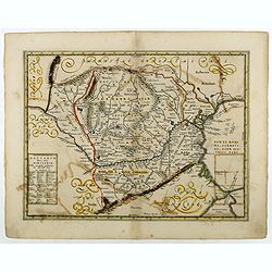
Walachia, Servia, Bulgaria, Romania
Nice map of the Eastern Balkans.Mercator was born in Rupelmonde in Flanders and studied in Louvain under Gemma Frisius, Dutch writer, astronomer and mathematician. The ex...
Date: Amsterdam, 1630
Selling price: ????
Please login to see price!
Sold
Vetus Descriptio Daciarum Nec non Moesiarum. . .
A decorative map of ancient Dacia and Moesia, namely today's Romania, with Serbia and part of Bulgaria, With a beautiful cartouche. Signed lower part: Petrus Kaerius Cael...
Date: Amsterdam, ca 1660
Selling price: ????
Please login to see price!
Sold in 2020
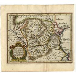
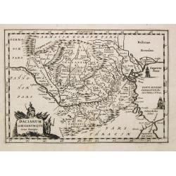
Daciarum Moesiarum que, Vetus Descriptio
Handsome small map of the ancient region of Romania and Bulgaria based on Ortelius' map of the same title. Filled with old place names and embellished with a fine title c...
Date: Amsterdam 1661
Selling price: ????
Please login to see price!
Sold
Daciarum Moesiarum que, Vetus Descriptio.
Handsome small map of the ancient region of Romania and Bulgaria based on Ortelius' map of the same title. Filled with old place names and embellished with a fine title c...
Date: Amsterdam, 1661
Selling price: ????
Please login to see price!
Sold in 2008
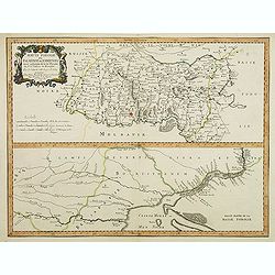
Haute Podolie ou Palatinat de Kamieniec tirée entièrement de la Gr. Ukranie. . .
Two maps on one sheet covering parts of Romania. Prepared by Guillaume Le Vasseur de Beauplan (1600-1685).
Date: Paris, 1665
Selling price: ????
Please login to see price!
Sold in 2011
ROMANIA, THRACE, BULGARIA. -Exactissima Tabula qua tam DANUBII FLUVII PARS INFERIOR, . .
A beautifully colored map depicting the region to the lower reaches of the Danube from Belgrade to the Black Sea. Includes all of Romania, Bulgaria, most of Serbia and Th...
Date: Amsterdam, 1680
Selling price: ????
Please login to see price!
Sold in 2021
Daciarum Moesiarumque Vetus Descriptio.
A map of Rumania and Bulgaria.
Date: Amsterdam, 1683
Selling price: ????
Please login to see price!
Sold
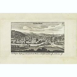
Temeswar. (Timisoara)
View of TimiSoara is a city in the Banat region of western Romania. It is the capital of TimiS County.
Date: Nuremberg, Jacob Sandrart, 1684
Selling price: ????
Please login to see price!
Sold in 2018
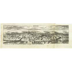
Wardein.
Panoramic view of Grosswardein or NagyváradWardein (Oradea), in northwest Romania near the Hungarian border. Published in "Der Donau-Strand Mit allen seinen Ein- un...
Date: Nuremberg, Jacob Sandrart, 1684
Selling price: ????
Please login to see price!
Sold in 2022
![[Plan of a town]](/uploads/cache/43021-250x250.jpg)
[Plan of a town]
City plan of Satmar in Romania, engraved by Johann Martin Lerch (1659-1684) from Vienna.
Date: Vienna, ca.1686
Selling price: ????
Please login to see price!
Sold in 2019
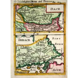
Dace/ Thrace.
Alain Manneson Mallet (1603-1706) published in 1683 his ' Description de l' Univers' in 5 volumes. In 1686 a German edition appeared.Map of the ancient Balkan. From the G...
Date: Paris, 1687
Selling price: ????
Please login to see price!
Sold in 2019
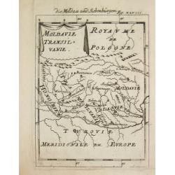
Moldavie Transilvanie.
Alain Manneson Mallet (1603-1706) published in 1683 his ' Description de l' Univers' in 5 volumes. In 1686 a German edition appeared.Map of Rumania. From the German editi...
Date: Paris, 1687
Selling price: ????
Please login to see price!
Sold
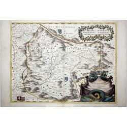
LA TRANSILVANIA. . .
A beautiful map of the Transilvanian regions in Romania, depicting several kingdom's crests around the map.
Date: Venetia, 1690
Selling price: ????
Please login to see price!
Sold in 2020
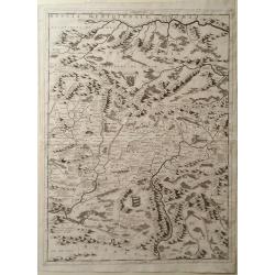
Map of Romania, Including Transylvania
Map of Romania including Transylvania by Vincenzo Coronelli. Overall a wonderfully detailed composition which features the location of Major Mountain ranges rivers and ma...
Date: Venice, 1698
Selling price: ????
Please login to see price!
Sold in 2010
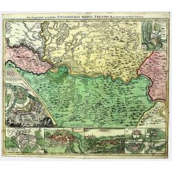
SERBIA - BANAT. UNGARISCHES KRIEGS THEATRUM.
A large and detailed, very decorative map of the theatre of war between the Austrians and Ottoman Turks 1716-17, fought in Romania and Serbia. Under Prince Eugene of Savo...
Date: Nuremberg, 1718
Selling price: ????
Please login to see price!
Sold in 2022
Turquie en Europe.
A nice little map of Greece.
Date: Amsterdam, 1721
Selling price: ????
Please login to see price!
Sold
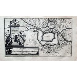
Plan Van de Stadt en't Kasteel Van TEMISWAR.
Unusual map of Temesvár or Timișoara. Shows the city fortifications being attacked. With a large decorative title with figures and weapons. Includes an inset vi...
Date: Amsterdam, 1735
Selling price: ????
Please login to see price!
Sold in 2020
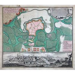
Temeswaria Oppidum superioris Hungariae. . .
Rare, large town-plan and view of the city of Timisoara, in Romania. In old original colors
Date: Augsburg, 1740
Selling price: ????
Please login to see price!
Sold in 2013
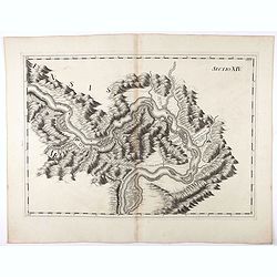
Sectio XIV.
Map of part of the Danube showing section in Romania. Prepared by Count Luigi Ferdinando Marsili (1658 - 1730) who was an Italian scholar and eminent natural scientist. P...
Date: Amsterdam, 1744
Selling price: ????
Please login to see price!
Sold in 2020
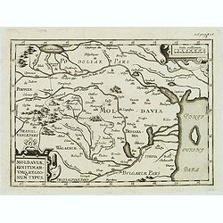
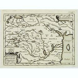
Moldaviae, finitimar umo regionum typus.
Uncommon map of Moldavia published in the second edition of Martinus Broniovius "Tartariae description ..." His work appeared first in 1595. The second edition ...
Date: Vienna, 1746-1748
Selling price: ????
Please login to see price!
Sold
Moldaviae, finitimar umo regionum typus.
Uncommon map of Moldavia published in the second edition of Martinus Broniovius "Tartariae description ..." His work appeared first in 1595. The second edition ...
Date: Vienna, 1746-1748
Selling price: ????
Please login to see price!
Sold in 2012
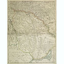
Carte de la Moldavie dressée sur celle du prince Cantimir. . .
Extremely rare map of the north of Moldavia and the regions today in Ukraine. In top the title Moldavie Septentrionale. Another map of the southern part exists to complem...
Date: Paris, 1770
Selling price: ????
Please login to see price!
Sold in 2011
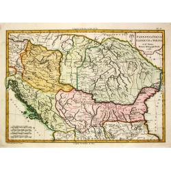
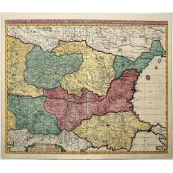
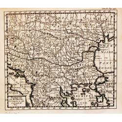
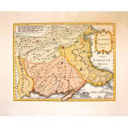
Pannonia, Dacia, Illyricum et Moesia. 1783.
Jean Lattré, Paris-based engraver and publisher. Worked with Robert de Vaugondy, J. Janvier and R. Bonne. " Atlas Monderne', 1771, 1783 , 1793. Rigobert Bonne (1727...
Date: Paris, 1783
Selling price: ????
Please login to see price!
Sold in 2018
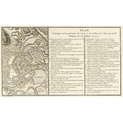
Plan de l\'Attaque du Retranchement, du Camp, et de la Flotte des Turcs par le Gal. Weisman, près de Tultschi, le 30 Juin 1771
Engraved map of the Danube River between Tulcea in Romania and Izmail in Moldavia. With detail of the expeditions of General Weissman in 1771. From the Atlas Volume of &q...
Date: Paris, 1783
Selling price: ????
Please login to see price!
Sold in 2010
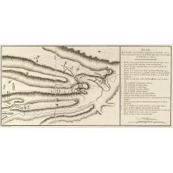
Plan des Expéditions faites par le Gal. Weissman de l\'autre côté du Danube contre Tultschi & Isaktschi. Attaque de Tultschi le 4 Avril 1771
Engraved map of the Danube River between Isaccea, Tulcea in Romania and Izmail in Moldavia. With detail of the expeditions of General Weissman in 1771. From the Atlas Vol...
Date: Paris, 1783
Selling price: ????
Please login to see price!
Sold in 2010
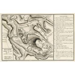
Bender Assiégé & pris par les Russes en 1770
Engraved map of the Battle of Bender in today Moldavia during the Russo-Turkish War 1768-1774 in 1770. From the rare Atlas Volume of "Histoire physique, morale, civi...
Date: Paris, 1783
Selling price: ????
Please login to see price!
Sold in 2009
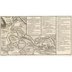
Plan de l'Attaque & de la Victoire remportée par les Russes sur les Turcs et les Tartars près du Large en Moldavie le 7 Julliet, 1770
Engraved map of the Battle of at the Large in today Moldavia during the Russo-Turkish War 1768-1774 on 7 July 1770. From the rare Atlas Volume of "Histoire physique,...
Date: Paris, 1783
Selling price: ????
Please login to see price!
Sold in 2009
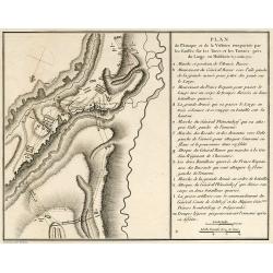
Plan de la Bataille & de la Victoire remportée par les Russes sur les Turcs commandés par le Grand Visir près de la riviere Kagul en Bessarabie. le 21 Julliet, 1770
Engraved map of the Battle of Cahul in today Moldavia during the Russo-Turkish War 1768-1774 on 21 July 1770. From the rare Atlas Volume of "Histoire physique, moral...
Date: Paris, 1783
Selling price: ????
Please login to see price!
Sold in 2009
Die Landschaft Romanien, No 16.
Detailed copperplate map featuring parts of Turkey and Southern Bulgaria. Included is Constantinopel. Joseph von Reilly (1766 – 1820) was a Viennese art dealer who tu...
Date: Vienna, 1789
Selling price: ????
Please login to see price!
Sold in 2016
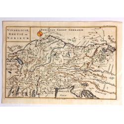
Vindelicie, Rhetie en Norikum.
Striking copper engraved original map of Greece, Bulgaria, Romania, and Macedonia. Christopher Cellarius (C. Keller) (1638-1707) was a geography professor who held positi...
Date: London, 1796
Selling price: ????
Please login to see price!
Sold in 2017
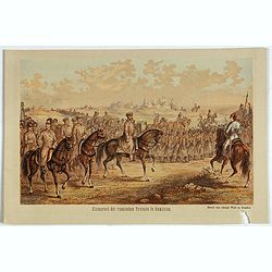
Einmarsch der russischen truppen in Romänien.
Showing the Russian arriving in Romaniia during the Russian-Turkish War (1828-1829) . Russian troops occupied Wallachia and Moldova for a few years.
Date: Dresden, 1880
Selling price: ????
Please login to see price!
Sold in 2023
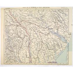
Carte de la Roumanie et Pays limitrophes. Balta. ODESSA.
Very detailed (1:750.000) map centered on Odessa and Moldova and Ukraine territory. Made after an Austrian map. The French Service géographique des armées was founded i...
Date: Paris, 1912
Selling price: ????
Please login to see price!
Sold in 2014
