Browse Listings in Europe > Eastern Europe > Balkans
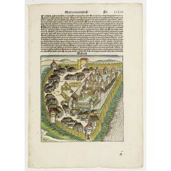
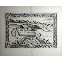
Sexta Etas Mudi. Sabatz. Folio CCLIII (with view of Sabac in Serbia)
An imaginary view of Sabac in Serbia, however the earliest obtainable view of this period.In 1476 King Matthias of Hungary defeated the invading Turkish armies at Sabac, ...
Date: Nuremberg, 12 July 1493
Selling price: ????
Please login to see price!
Sold in 2024
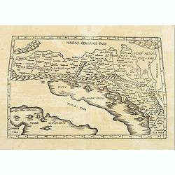
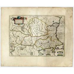
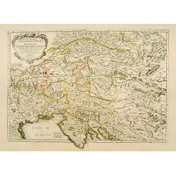
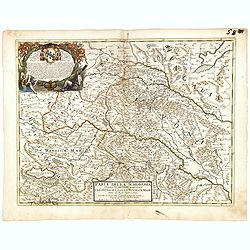
EUROPAE Tabula Quinta continet Rhetiam et Vindeliciam?
A Ptolemaic map of the Dalmatian coast but also showing parts of Italy, and the northern tip of Corsica. ¤
Date: Vienne, 1541
Selling price: ????
Please login to see price!
Sold in 2009
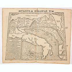
Tabula Europae V ( Adriatic Sea and the Balkans)
The first edition of Munster's Ptolemaic map of the Adriatic Sea and the Balkans appeared in his "Geographia Universalis", first published in 1540. This was a n...
Date: Basel, Heinrich Petri, 1545
Selling price: ????
Please login to see price!
Sold in 2014
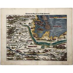
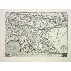
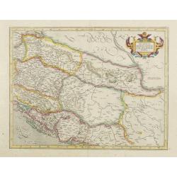
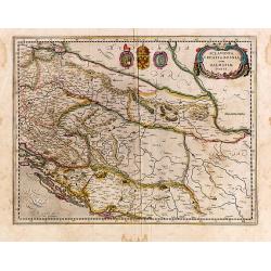
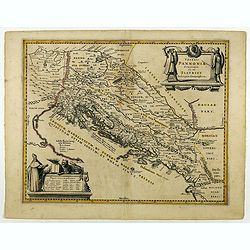
SCLAVONIA ODER WINDISCH MARCK, BOSSEN, CRABATEN (Croatia, Dalmatia)
A beautifully colored, antique woodcut map of Dalmatia, Bosnia, Slovenia, Croatia.
Date: Basle, 1550
Selling price: ????
Please login to see price!
Sold in 2021
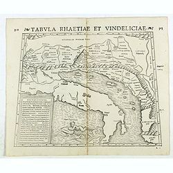
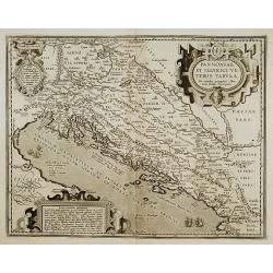
Tabula Rhaetiae et Vindeliciae. (Adriatic coast and Balkan States, Dalmatia, etc.)
Double-page woodcut Ptolemaic-style map by Sebastian Münster figuring Adriatic coast and Balkan States, Dalmatia, etc., published in the edition of Strabo by Henri Petri...
Date: Basle, Henri Petri, 1571
Selling price: ????
Please login to see price!
Sold in 2018
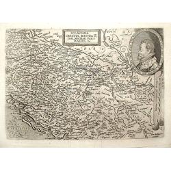
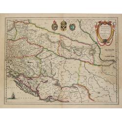
Schlavoniae, Croatiae, Carniale.. Bosniae..
First state. Fine and early map of former Yugoslavia after a map of Hirschvogel (1552-1565) and used by A.Ortelius in his atlas 'Theatrum Orbis Terrarum [Atlas of the Who...
Date: Antwerp 1584
Selling price: ????
Please login to see price!
Sold
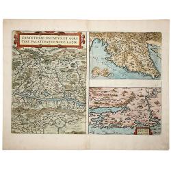
CARINTHIAE DUCATUS, ET GORITIAE PALATINATUS, WOLF. LAZIO -Histriae tabula a Petro Coppo defer - ZARAE, ET SEBENICI DESCRIPTION
A striking set of three maps on a single sheet, including the region around Villach on the Dravus River, the Gulf of Trieste and Quarnero and the region around Zara [Zada...
Date: Antwerp, 1584
Selling price: ????
Please login to see price!
Sold in 2019
Illyricum
Ortelius' map of the region from Triest and Villach in the west, to Brod in the east, along the course of the Sava, centered on Zagreb and Novograd. Includes nice detail ...
Date: Antwerp, 1588
Selling price: ????
Please login to see price!
Sold in 2021
![[De istria Peninsula.]](/uploads/cache/32532-250x250.jpg)
[De istria Peninsula.]
On verso a wood block printed map of the triangular peninsula of Istria pointing down into the northern Adriatic. From a Latin text edition of his Geographia, that great ...
Date: Basle, 1550-1590
Selling price: ????
Please login to see price!
Sold in 2013
![[Untitled.] A Rarity of the Balkans with Fine Original color. Balkans/ Greece/ Istanbul.](/uploads/cache/82204-250x250.jpg)
[Untitled.] A Rarity of the Balkans with Fine Original color. Balkans/ Greece/ Istanbul.
A rare and attractive work with rich, full, original color; one of the earliest atlas maps to focus on Serbia and the lands around the mouth of the Danube. The map also p...
Date: Antwerp, 1593
Selling price: ????
Please login to see price!
Sold in 2019
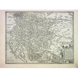
Pannoniae, et Illyrici Veteris Tabula.
Made on the basis of Gastaldi's 1560 map of South East Europe and on information from ancient sources, specifically Plinius, Livius, Bonfinius, Dionus and Aurelius Victor...
Date: Antwerp 1595
Selling price: ????
Please login to see price!
Sold
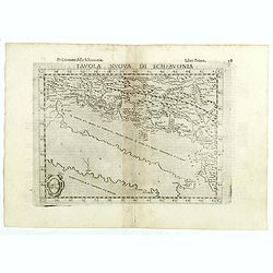
Tavola nuova di Schiavonia.
The third state of Ruscelli's map of the Balkans, with a coat of arms in lower left corner, based upon Claudius Ptolemy. Girolamo Ruscelli first published the map in his ...
Date: Venice, 1598
Selling price: ????
Please login to see price!
Sold in 2018
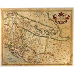
Schlavoniae, Croatiae, Carniale.. Bosniae. . .
First state. Fine and early map of former Yugoslavia after a map of Hirschvogel (1552-1565) and used by A.Ortelius in his atlas 'Theatrum Orbis Terrarum [Atlas of the Who...
Date: Antwerp, 1598
Selling price: ????
Please login to see price!
Sold in 2014
Schlavoniae, Croatiae, Carniale.. Bosniae. . .
Fine and early map of former Yugoslavia after a map of Hirschvogel (1552-1565) and used by A.Ortelius in his atlas 'Theatrum Orbis Terrarum [Atlas of the Whole World]. Wi...
Date: Antwerp, 1598
Selling price: ????
Please login to see price!
Sold in 2022
![Rovigno [View of Rovinj]](/uploads/cache/45192-250x250.jpg)
Rovigno [View of Rovinj]
Very rare view of Rovinj in Croatia situated on the north Adriatic Sea. Located on the western coast of the Istrian peninsula, it is a popular tourist resort and an activ...
Date: Venice, Giacomo Franco, 1598
Selling price: ????
Please login to see price!
Sold in 2023
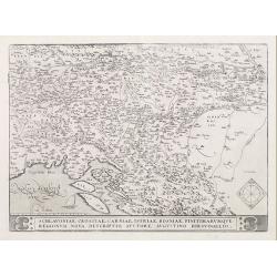
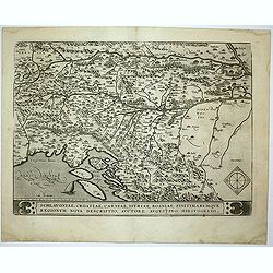
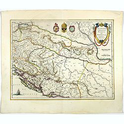
Schlavoniae, Croatiae, Carniae, Istriae, Bosniae...
Detailed early map after Hirschvogel of Southern Austria, Slovenia, Croatia, Bosnia and a small part of Italy. Artfully engraved map with many place names, showing towns,...
Date: Antwerp, c1600
Selling price: ????
Please login to see price!
Sold
Illyricum
Detailed early map of Istria, Slovenia and parts of Croatia. Skillfully engraved towns, mountains, woods and rivers! First issued 1572 by Johannes Sambucus, this is the 2...
Date: Antwerp. c1600
Selling price: ????
Please login to see price!
Sold
Sclavonia Croatia, Bosnia & Dalmatiae Pars Maior.
Matthias Quadt (1557-1613), Dutch geographer, worked in Cologne. ' Europae', 1592, 'Geographisch handtbuch, 1600 and Fasciculus Geographicus'. Johan Bussemacher published...
Date: Cologne, 1600
Selling price: ????
Please login to see price!
Sold in 2018
Sclavonia, Croatia, Bosnia cum Dalmatiae Parte.
Detailed and early map of the former Yugoslavia. Signed lower left.
Date: Amsterdam, 1606
Selling price: ????
Please login to see price!
Sold in 2008
![[Lot of 7 maps of the Balkan] ILLYRICUM.](/uploads/cache/IMG_9507-250x250.jpeg)
[Lot of 7 maps of the Balkan] ILLYRICUM.
Abraham Ortelius(1527-98), Dutch cartographer and publisher of the first modern atlas, ' Theatrum Orbis Terrarum' in 1570. Editions till 1612. Also an atlas of ancient ca...
Date: Antwerp, 1609
Selling price: ????
Please login to see price!
Sold in 2022
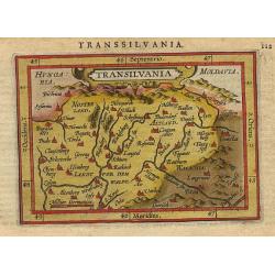
Transilvania
Miniature map of Transilvania, with major cities named. Strapwork title cartouche at the top. Latin text on verso.
Date: Antwerp 1609
Selling price: ????
Please login to see price!
Sold
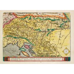
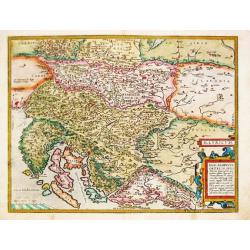
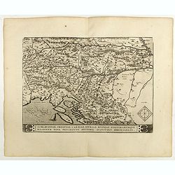
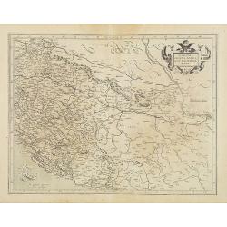
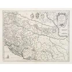
Schlavoniae, Croatiae, Carniae, Istriae, Bosniae, Finitimarumque Regionum Nova Descriptio.
Abraham Ortelius’ map is based on the map of the Turkish border by Augustin Hirschvogel of 1539. Third state. From the rare Spanish edition of Abraham Ortelius’ ‘Th...
Date: Antwerp, 1609
Selling price: ????
Please login to see price!
Sold in 2021
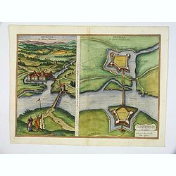
Petrina.
Left hand side reads: Petrina under Turkish Rule, Right hand side reads: Petrina under Christian Rule. After the Turkish conquests in the 16th century, western Croatia re...
Date: Cologne, 1617
Selling price: ????
Please login to see price!
Sold in 2020
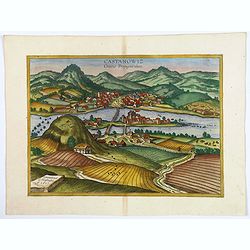
Castanowiz Croatiae Propugnaculum.
This is a view from the south of the village with its watchtower and church, in the setting of an idyllic rural wine-growing area. The village lies on the north bank of t...
Date: Cologne, 1617
Selling price: ????
Please login to see price!
Sold in 2020
WALACHIA, SERVIA, BULGARIA, ROMANIA.
A decorative, striking example of Blaeu's map of the Lower Danube, Bulgaria, Romania, Serbia and Macedonia.
Date: Amsterdam, 1619
Selling price: ????
Please login to see price!
Sold in 2020
Sclavonia, Croatia, Bosnia cum Dalmatiae parte.
Nice map of the Eastern Balkans with the geographical & political divisions of Dalmatia, Croatia, Slavonia, Bosnia, Serbia, etc.Mercator was born in Rupelmonde in Fla...
Date: Amsterdam, 1630
Selling price: ????
Please login to see price!
Sold

Sclavonia, Bosnia cum Dalmatiae parte.
Excellent map with coat-of-arms focusing specifically on the embattled nations of the former Yugoslavia.
Date: Amsterdam, 1630
Selling price: ????
Please login to see price!
Sold
Sclavonia, Croatia, Bosnia cum Dalmatiae Parte.
Willem Blaeu, father of Johan and Cornelis Blaeu, was the founder of the famous publishing firm. Originally publishing pilot-guides, he issued his first atlas, 'Atlantis ...
Date: Amsterdam, c.1630
Selling price: ????
Please login to see price!
Sold
Sclavonia, Croatia, Bosnia cum Dalmatiae Parte. . .
An attractive map of the Eastern Balkans with the geographical & political divisions of Dalmatia, Croatia, Slavonia, Bosnia, Serbia, etc. (currently Croatia, Bosnia &...
Date: Amsterdam, 1630
Selling price: ????
Please login to see price!
Sold in 2016
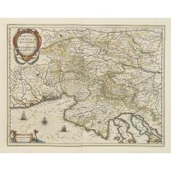
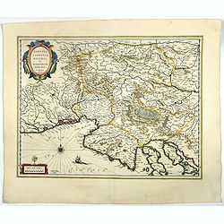
Karstia, Camiola, Histria et Windorum Marchia.
Including the Gulf of Trieste, Venise and the northern part of former Yugoslavia. Prepared by Gerard Mercator.
Date: Amsterdam, 1638
Selling price: ????
Please login to see price!
Sold
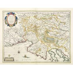
Karstia, Camiola, Histria et Windorum Marchia.
Including the Gulf of Trieste, Venice and the northern part of former Yugoslavia. Prepared by Gerard Mercator.With the signature of Willem Blaeu in lower left corner. As ...
Date: Amsterdam, 1638
Selling price: ????
Please login to see price!
Sold in 2023
Sclavonia, Croatia cum Dalmatiae Parte.
Excellent map with coat-of-arms focusing specifically on the embattled nations of the former Yugoslavia. As Willem Blaeu died in 1638 most of his maps are actually publis...
Date: Amsterdam, 1638
Selling price: ????
Please login to see price!
Sold in 2023
Sclavonia, Croatia cum Dalmatiae Parte.
Excellent map with coat-of-arms focusing specifically on the embattled nations of the former Yugoslavia. French text on verso.
Date: Amsterdam, 1638
Selling price: ????
Please login to see price!
Sold in 2015
Sclavonia, Croatia cum Dalmatiae Parte.
Excellent map with coat-of-arms focusing specifically on the embattled nations of the former Yugoslavia.Latin text on verso.
Date: Amsterdam 1638
Selling price: ????
Please login to see price!
Sold
Sclavonia, Croatia, Bosnia cum Dalmatiae Parte.
Detailed and early map with coat-of-arms focusing specifically on the embattled nations of the former Yugoslavia. Signed lower left.
Date: Amsterdam, 1639
Selling price: ????
Please login to see price!
Sold in 2014
Karstia, Camiola, Histria et Windorum Marchia.
Map by Willem Blaeu, including the Gulf of Trieste, Venice and the northern part of former Yugoslavia. Prepared by Gerard Mercator.With the signature of Willem Blaeu in l...
Date: Amsterdam, 1644
Selling price: ????
Please login to see price!
Sold in 2022
Sclavonia, Croatia cum Dalmatiae Parte.
Important map by Blaeu with a set of three coat-of-arms hinting at the regions history as they reflect the Ottoman Empire, the Venetian Republic the double headed eagle.D...
Date: Amsterdam, 1644
Selling price: ????
Please login to see price!
Sold in 2017
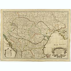
Veteris Pannoniae Utriusque Nec non Illyrici...
Uncommon map of Adriatic Sea. Decorated with two large scale cartouches, one showing two swordsman at odds with one another and the other a royal figure holding a scepter...
Date: Amsterdam, 1646
Selling price: ????
Please login to see price!
Sold in 2018
![Marchant Ragusej (35) [Coatia]](/uploads/cache/31549-250x250.jpg)
Marchant Ragusej (35) [Coatia]
Sought-after copper engraved plate from Laonikos Chalcocondyle’s "L'histoire de la décadence de l'empire grec et establissement de celuy des Turcs." by Thoma...
Date: Paris, Mathieu Guillemot, 1650
Selling price: ????
Please login to see price!
Sold in 2011
![Qsante de Raguse ou porteur de lettres. (36) [Coatia]](/uploads/cache/31550-250x250.jpg)
Qsante de Raguse ou porteur de lettres. (36) [Coatia]
Sought-after copper engraved plate from Laonikos Chalcocondyle’s "L'histoire de la décadence de l'empire grec et establissement de celuy des Turcs." by Thoma...
Date: Paris, Mathieu Guillemot, 1650
Selling price: ????
Please login to see price!
Sold in 2011
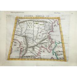
Europae Tabula IX .
A fine Ptolemaic map that covers the Balkans and includes the Bosphorus one of the earliest maps of Turkey and Macedonia. The map, drawn on a trapezoidal projection, is b...
Date: Venice, 1654
Selling price: ????
Please login to see price!
Sold in 2016
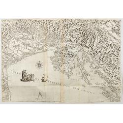
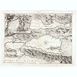
Golfo di Venetia overo Mare Adriatico.
Extremely rare map of the Gulf of Venice, or the Adriatic Sea, published in Venice by Stefano Scolari : Stefano Scolari formin in Venetia a Szulian. The Scale is approxim...
Date: Venice, c. 1660
Selling price: ????
Please login to see price!
Sold in 2026
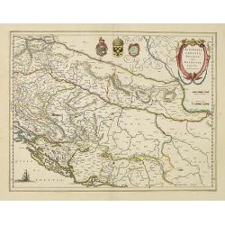
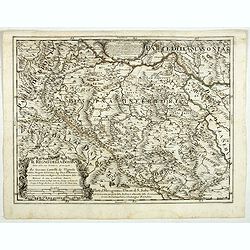
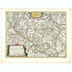
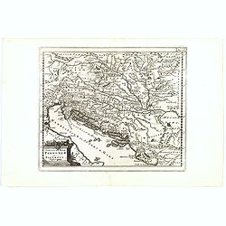
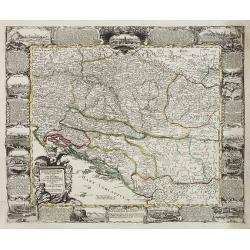
Illyricum Occidentis. Cuj Partes IV Rhaetia, Noricum Pannonia, et Illyris. . .
Attractive historical map of the area Balkans, Hungary, Austria, the Adriatic and the northern part of Italy. Engraved by Louis Cordier. Based on the cartography of Nicol...
Date: Paris, 1666
Selling price: ????
Please login to see price!
Sold in 2013
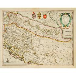
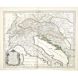
Hertzogthuber Steyer, Karnten, Krain, &, Duchés de Stirie, Carinthie, Carniole...
Fine map of Austria, Slovenia and north-eastern part of Italy including Venice, Udine, Trieste.This edition carries the date 1679. Nicolas Sanson was to bring about the r...
Date: Paris, 1679
Selling price: ????
Please login to see price!
Sold in 2010
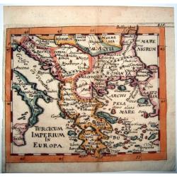
TURCICUM IMPERIUM IN EUROPA.
Rare copperengraved map of the Ottoman Empire's possessions in Europe - Greece and the Balkans, published by Hoffmann, Nuremberg 1679, in his 'Atlas Universalis' ,a pirat...
Date: Nuremberg, 1679
Selling price: ????
Please login to see price!
Sold in 2021
Dalmatia Istria Bosnia Servia Croatia e parte di Schiavonia...
Giacomo Rossi's fine late 17th century map of Dalmatia, with cartouches for the title and dedication. Engraved by Francesco Donia after Vignola. Issued in Il Mercurio geo...
Date: Rome, 1684
Selling price: ????
Please login to see price!
Sold in 2015
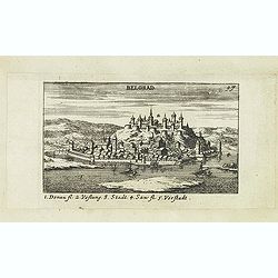
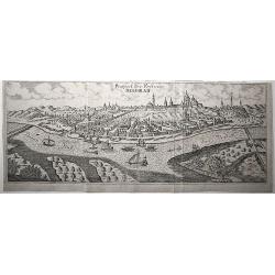
Belgrad.
Panoramic of Belgrade. Belgrade is the capital and largest city of Serbia. The city lies at the confluence of the Sava and Danube rivers, where the Pannonian Plain meets...
Date: Nuremberg, Jacob Sandrart, 1684
Selling price: ????
Please login to see price!
Sold in 2019
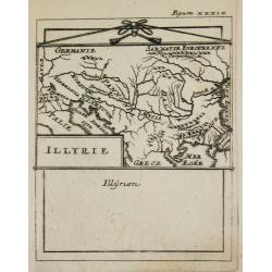
Illyrie.
Alain Manneson Mallet (1603-1706) published in 1683 his ' Description de l' Univers' in 5 volumes. In 1686 a German edition appeared.Map of the ancient Balkan. From the G...
Date: Paris, 1687
Selling price: ????
Please login to see price!
Sold
Il regno della Bossima diviso nelle sue provincie principali. . .
Rossi's map of Bosnia, based upon Sanson's map, but with revised Italian nomenclature. From a second edition of his 'Mercurio Geografico...'. The engraver was Cl. Botzot....
Date: Rome, 1689
Selling price: ????
Please login to see price!
Sold in 2019
Il regno della Bossima diviso nelle ...
Rossi's map of Bosnia, based upon Sanson's map.
Date: Rome, 1689
Selling price: ????
Please login to see price!
Sold in 2016

Il regno della Bossima diviso nelle sue provincie principali. . .
Rossi's map of Bosnia, based upon Sanson's map, but with revised Italian nomenclature. From a second edition of his 'Mercurio Geografico...'. The engraver was Cl. Botzot....
Date: Rome, 1689
Selling price: ????
Please login to see price!
Sold in 2025
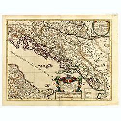
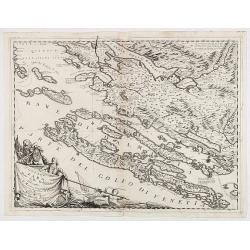
Ristretto Della Dalmazia Divisa Ne Suoi Contadi Gia Presentata Alla Serenissima Republica Di Venezia . . .
Elaborate two sheet map of the coast of Dalmatia, extending from Istria and Croatia in the north to Bosnia, Herzegovina, Serbia and Albania in the South. Two ornate carto...
Date: Venice, 1690
Selling price: ????
Please login to see price!
Sold in 2012
Chnin/Fortezza nella Dalmatia. Conqustata alla SS. Republica di Venetia. Dall eccellenza del sig. Cau: proc: Girolamo Corner/Generale De Dalmatia et Albania etc: Dedicata/ All' Illustrissimo Sig: Catarino Primogenita Suo.
Vincenzo Coronelli was both cleric and encyclopedist, with a particular interest in geography and cartography. He joined the Franciscan Order in Venice in 1665 and six ye...
Date: Venice, 1690
Selling price: ????
Please login to see price!
Sold in 2010
Parte della Schiavonia, overo Slavonia, aggiuntavi la contea di Cilles e Windisch mark abitate da populi slavini, ò slavi. . .
Rossi's map of Slovenia with in center the Rivers Drave and Savinja, based upon Sanson's map, but with revised Italian nomenclature. The engraver was Giorgio Widman.Issue...
Date: Rome, 1692
Selling price: ????
Please login to see price!
Sold in 2015
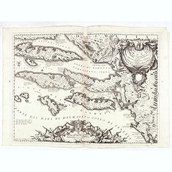
Stato di Ragusi Bocca del fiume Narenta, Isole di Lesina . . .
Map of the Republic of Dubrovnik. It shows the territory of the Republic of Dubrovnik, which included the greater Dubrovnik area comprising the mouth of the river Neretva...
Date: Venice, 1696
Selling price: ????
Please login to see price!
Sold in 2020
Ristretto Della Dalmazia Divisa Ne Suoi Contadi Gia Presentata Alla Serenissima Republica Di Venezia . . .
Elaborate map of the coast of Dalmatia.From Coronelli's rare Atlante Veneto, one of the most decorative and ornate of all 17th century atlases. Engraved in Coronelli's un...
Date: Venice, 1696
Selling price: ????
Please login to see price!
Sold in 2020
Disegno topografico del canale di Cattaro . . .
Decorative and highly detailed map of a portion of the Gulf of Venice and Sea of Dalmatia, in the Hercag-Novi region of Serbia and Montenegro. A remarkable engraving, wit...
Date: Venice, 1696
Selling price: ????
Please login to see price!
Sold in 2020
Contado di Zara . . .
Striking map depicting the administrative territory of the Adriatic coasts taken between Istria and Albania and it represents one of the first thematic maps about the org...
Date: Venice, 1696
Selling price: ????
Please login to see price!
Sold in 2020
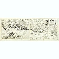
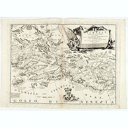
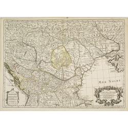
Veteris et Nova Pannoniae et Illyrici Descriptio.
A map of the north Balkans and northern Adriatic in ancient times. The map is based on the earlier Ortelius map of the same name. From Italy to Greece and inland to Morav...
Date: Amsterdam, ca. 1700
Selling price: ????
Please login to see price!
Sold in 2019
Veteris Pannonia utriusque nec non Illyrici descriptio Geographica . . .
A delightful map of the ancient Dalmatian coastline, that includes parts of modern day Austria, Hungary and Croatia, engraved by Joseph Thoal, and printed at the Seminary...
Date: Padua, ca 1700
Selling price: ????
Please login to see price!
Sold in 2023
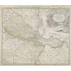
Carte de la Hongrie et des pays qui en dependoient autrefois. . .
Map of Hungary and the Balkans with the address : Chez l’Auteur sur le Quai de l’Horloge avec Privilege du Roy pour 20 ans, 1703. Lower right, Renard’s imprint is e...
Date: Paris, 1703
Selling price: ????
Please login to see price!
Sold in 2018
Carte de la Hongrie et des pays qui en dependoient autrefois. . .
The edition by Buache of Delisle's important map of Hungary and the Balkans. It is the first map depicting the Danube bend and the river fairly accurately. Fine decorativ...
Date: Paris, 1703
Selling price: ????
Please login to see price!
Sold in 2009
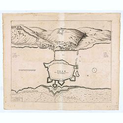
TRAW Ville de la Republique de Venise dans la Dalmatie.
Large view of the port city of Trogir (Trau) in Croatia with the fortress from a half bird's eye view. Joan Blaeu published during his life three town-books of Italy: Cit...
Date: Amsterdam, 1704- 1705
Selling price: ????
Please login to see price!
Sold in 2020
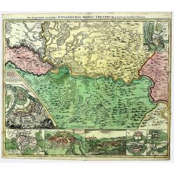
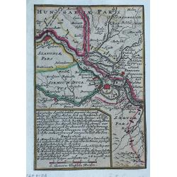
SERBIA - BANAT. UNGARISCHES KRIEGS THEATRUM.
A large and detailed, very decorative map of the theatre of war between the Austrians and Ottoman Turks 1716-17, fought in Romania and Serbia. Under Prince Eugene of Savo...
Date: Nuremberg, 1718
Selling price: ????
Please login to see price!
Sold in 2022
Les Isles et Coste de la Dalmatie ou se Trouvent la Republique de Raguse..
Fine map of the Dalmatian coast with a decorative title cartouche.Presents vessels in the Adriatic Sea and some text containing information about the Republic of Ragusa, ...
Date: Paris, 1719
Selling price: ????
Please login to see price!
Sold in 2010
Les Isles et Coste de la Dalmatie. . .
An interesting map of the Dalmatian coast with the Republique of Raguse (Dubrovnik) at the centre. Based on Sanson's map from 1665. The area shown extends from Zadar in C...
Date: Paris, 1719
Selling price: ????
Please login to see price!
Sold in 2014
Les Isles et Coste de la Dalmatie ou se Trouvent la Republique de Raguse..
Fine map of the Dalmatian coast with a decorative title cartouche.Presents vessels in the Adriatic Sea and some text containing information about the Republic of Ragusa, ...
Date: Paris, 1719
Selling price: ????
Please login to see price!
Sold in 2016
![[. . .] rte Ancienne et Moderne des Differents Etats et Pais situez au Long du Danube, pour servir a L'Intelligence De L'His [. . .]](/uploads/cache/34428-250x250.jpg)
[. . .] rte Ancienne et Moderne des Differents Etats et Pais situez au Long du Danube, pour servir a L'Intelligence De L'His [. . .]
A striking and highly detailed copper engraved plate with a map of region north of the Adriatic Sea and centered on the Danube River, from Croatia to the Black Sea. Inclu...
Date: Amsterdam, 1720
Selling price: ????
Please login to see price!
Sold in 2014
Vindelicia Rheti.
Nice original colored map with cartouche and coins on it. There are a few pencil lines on it.
Date: Nurnberg, 1720
Selling price: ????
Please login to see price!
Sold in 2010
Plan van de Slag gelevert tuschen het Leger van zyne Keyz. . . pris Eugenius van Savoyen. . tusschen Petervaradin en Carlowitz. . .
Uncommon engraving showing the Battle of Petrovaradin or Battle of Peterwardein, which was a decisive victory for Austrian forces in the war between Austria and the Ottom...
Date: Amsterdam, ca. 1720
Selling price: ????
Please login to see price!
Sold in 2011
Accurates lankärtlein worine...Belgrad
Rare map, centered on Belgrade. With a lettered key, probably referring to the siege of Belgrade of 1717.
Date: Augsburg, ca.1722
Selling price: ????
Please login to see price!
Sold in 2023
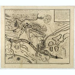
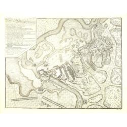
Plan de la Glorieuse Bataille donnee le 16 aout, 1717. Proche de Belgrade...
Title also in Dutch: ""Plan der Roemrugtige Veldslag Voorgevallen den 16 Augustus 1717 Digt by Belgrade ". Oriented to the southeast. Page placement in low...
Date: The Hague, van der Kloot, 1729
Selling price: ????
Please login to see price!
Sold in 2022
Plan de Temiswar … Plan van Temiswar.
Title also in Dutch: "Plan der Roemrugtige Veldslag Voorgevallen den 16 Augustus 1717 Digt by Belgrade ". Oriented to the southeast. Page placement in lower rig...
Date: The Hague, 1729
Selling price: ????
Please login to see price!
Sold in 2022
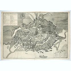
Prospect der Vestung Belgrad.
An exceptionally rare, unrecorded view of Belgrade, published around 1730.
Date: Unknown, ca. 1730
Selling price: ????
Please login to see price!
Sold in 2020
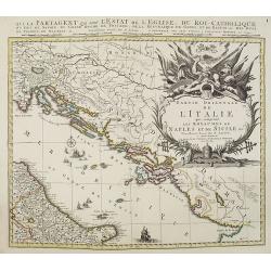
Partie orientale de L'Italie qui comprend les Royaumes de Naples et de Sicile. . .
Map of former Yugoslavia and the eastern part of Italy with a splendid baroque title cartouche with mythological figures. Title : Partie orientale de L'Italie qui compren...
Date: Amsterdam, ca. 1737
Selling price: ????
Please login to see price!
Sold in 2010
Danubii Fluminis pars media in qua Hungaria, Sclavonia..
Very rare "carte à figures" map of former Yugoslavia. With decorative title cartouche and surrounded by four borders with 13 city views each accompanied by lar...
Date: Augsburg, 1740
Selling price: ????
Please login to see price!
Sold
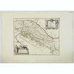
Tabula geographica exhibens regnum Sclavoniae. . .
Detailed copper-engraved map of Slavonia, the region in eastern Croatia. Belgrade to the east with the Danube, with the Sava a right side tributary of the Danube river.Ma...
Date: Nuremberg, 1745
Selling price: ????
Please login to see price!
Sold in 2011
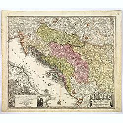
Nova et accurata.. Dalmatiae, Croatiae, Sclovoniae, Bosniae. . .
A finely engraved, large detailed map that includes the western part of the river Donau. Two decorative cartouches adorn the lower corners of the map. One of these shows ...
Date: Augsburg, 1760
Selling price: ????
Please login to see price!
Sold in 2018
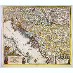
Nova et accurata.. Dalmatiae, Croatiae, Sclovoniae, Bosniae. . .
A finely engraved and large detailed map including the western part of the river Donau. Two decorative cartouches adorn the lower corners of the map. One with coats of ar...
Date: Augsburg, 1760
Selling price: ????
Please login to see price!
Sold in 2017
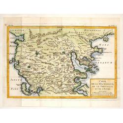
Carte de la Macedoine, de la Thessalie et de L'Epire.
Interesting copper engraved map of the Balkan region including what is currently Macedonia, Albania and northern Greece. Block style title cartouche. Jacques Nicolas Bel...
Date: Paris, 1760
Selling price: ????
Please login to see price!
Sold in 2013

