Browse Listings in Europe > British Isles > British Counties
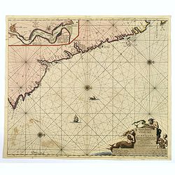
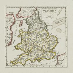
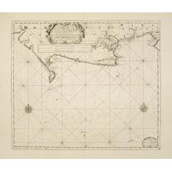
Nieuwe Pas-kaert vande Oost Kust van Engeland en Schotland. . .
A delightful Dutch maritime chart that includes the east coast of England, running from Berwick in Northumberland, southwards to Burlington in Yorkshire. A nice inset map...
Date: Amsterdam, 1690
Selling price: ????
Please login to see price!
Sold in 2019
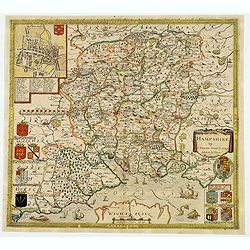
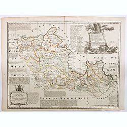
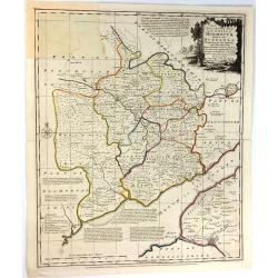
Hampshire.
Christopher SaxtonŌĆÖs sumptuous county map of Hampshire together with the northern part of the Isle of Wight, first issued in 1575, 'Corected & many Additions by P. ...
Date: London, ca 1690
Selling price: ????
Please login to see price!
Sold in 2021
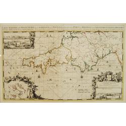
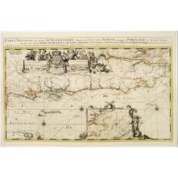
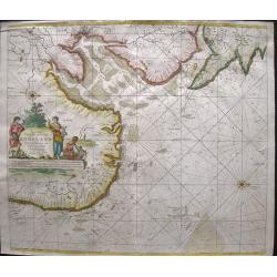
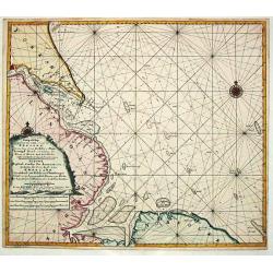
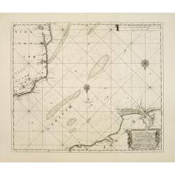
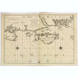
Carte Maritime de L'Angleterre depuis les Sorlingue jusques ├Ā Portland..
From the first edition of Mortier's Atlas Maritime, showing Cornwall and inset panoramic view of Portland.From Mortier's Neptune Fran├¦ois , one of the most spectacular c...
Date: Amsterdam 1693
Selling price: ????
Please login to see price!
Sold
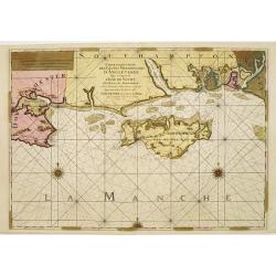
Carte Particuli├©re des Costes Meridionales d'Angleterre qui comprend L'Isle de Wicht..
Superb sea chart of the Isle of Wight and the South Hampshire coast between Bournemouth and Portsmouth. Three elaborate compass roses and rhumb lines grace the chart. Fro...
Date: Paris, (Amsterdam), 1693
Selling price: ????
Please login to see price!
Sold
Carte nouvelle des costes d'Angleterre depuis la rivi├®re de la Tamise jusques ├Ā Portland, & des Isles voisines..
Fine chart from the first edition of Mortier's Atlas Maritime, showing the south eastern coast of England, with river Thames.From Mortier's Neptune Fran├¦ois , one of the...
Date: Amsterdam 1693
Selling price: ????
Please login to see price!
Sold
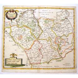
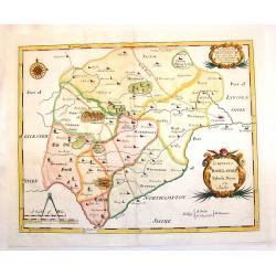
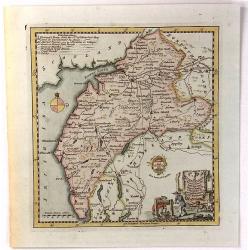
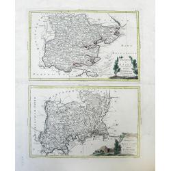
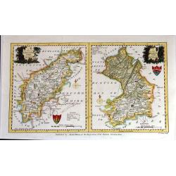
Leicestershire.
Fine, detailed English county map by Morden. Decorative title and scale cartouches. Robert Morden (c.1650-1703) was an English bookseller, publisher, and maker of maps a...
Date: London, 1695
Selling price: ????
Please login to see price!
Sold in 2014
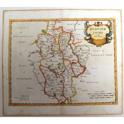
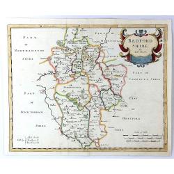
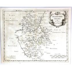
Bedfordshire.
County map of Bedfordshire by Morden. Nice cartouche. Published for "Camden's Britannia" Robert Morden (c.1650-1703) was an English bookseller, publisher, and ...
Date: London, 1695
Selling price: ????
Please login to see price!
Sold in 2013
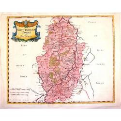
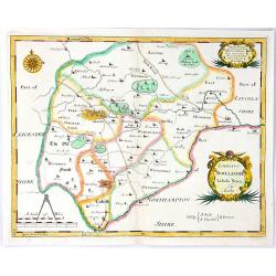
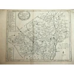
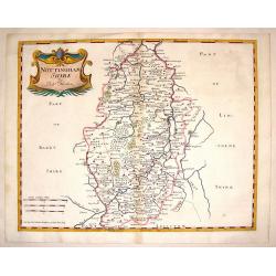
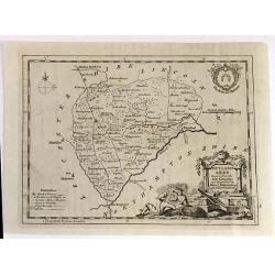
Nottinghamshire.
Striking copperplate map of Nottinghamshire showing details of cities, towns, rivers, roads and forests. Fine cartouche in left top corner. Robert Morden (c.1650-1703) wa...
Date: London, 1695
Selling price: ????
Please login to see price!
Sold in 2015
Comitatus Rotelandiae Tabula Nova & Aucta.
Nice 17th century copper engraved map featuring the Rutland county in England. Features the cities of Okeham & Uppingham and has two fancy Rococco title & descrip...
Date: London, 1695
Selling price: ????
Please login to see price!
Sold in 2015
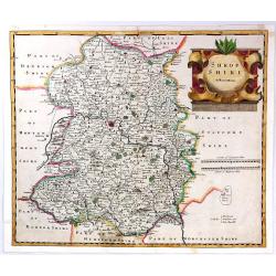
Shropshire By Robert Morden.
A copper engraved hand colored map of Shropshire, England. This map is one of the first country maps to show roads (based on Ogilby's road maps). It includes interesting ...
Date: London, 1695
Selling price: ????
Please login to see price!
Sold in 2018
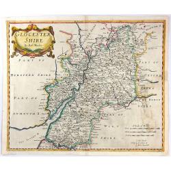
Glocestershire By Robert Morden.
A copper engraved hand colored map of Gloucestershire, England. This map is one of the first country maps to show roads (based on Ogilby's road maps). It includes interes...
Date: London, 1695
Selling price: ????
Please login to see price!
Sold in 2016
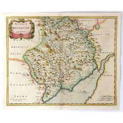
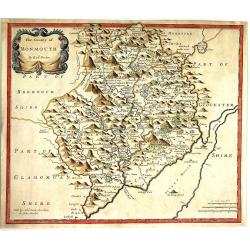
The County of Monmouth.
A detailed British county map by Robert Morden, from Camden's famous description of Great Britain, issued the late seventeenth century. Of particular interest is Morden's...
Date: London, 1695
Selling price: ????
Please login to see price!
Sold in 2016
Bedfordshire by Robt. Morden
A detailed British county map by Robert Morden from Camden's famous description of Great Britain, issued the late seventeenth century. Of particular interest is Morden's ...
Date: London, 1695
Selling price: ????
Please login to see price!
Sold in 2018
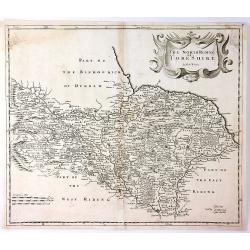
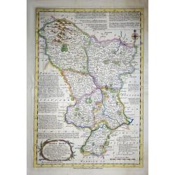
The North Riding of Yorkshire
A detailed British county map by Robert Morden from Camden's famous description of Great Britain, issued the late seventeenth century. Of particular interest is Morden's ...
Date: London, 1695
Selling price: ????
Please login to see price!
Sold in 2016
Comitatus Rotelandiae Tabula Nova & Aucta
An attractive, detailed map of the county of Rutland, EnglandŌĆÖs smallest county. The map was engraved by Robert Morden, and published in "Camden's Britannia"....
Date: London, 1695
Selling price: ????
Please login to see price!
Sold in 2016
The County of Monmouth
A pleasing first edition map of Monmouthshire by Robert Morden from his "CAMDEN'S BRITANNIA, published by Swale, Awnshaw & Churchil in London in 1695. Features a...
Date: London, 1695
Selling price: ????
Please login to see price!
Sold in 2016
Bedfordshire
A pleasing first edition map of Bedfordshire by Robert Morden from his "CAMDEN'S BRITANNIA, published by Swale, Awnshaw & Churchil in London in 1695. It features...
Date: London, 1695
Selling price: ????
Please login to see price!
Sold in 2016
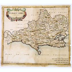
Dorsetshire.
A first edition county map of Dorsetshire by the English cartographer Robert Morden, published in his "Camden's Britannia" in London in 1695. An attractive titl...
Date: London, 1695
Selling price: ????
Please login to see price!
Sold in 2018
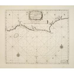
Pas-caert van de Zee-custen van ENGELAND van Orfordness tot aen Flamborger Hooft.
Beautifully colored sea chart of east coast of England, oriented to the West. Early state with engraved number 22. With nice decorations of the area and two compass rose...
Date: Amsterdam, 1697
Selling price: ????
Please login to see price!
Sold in 2016
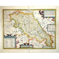
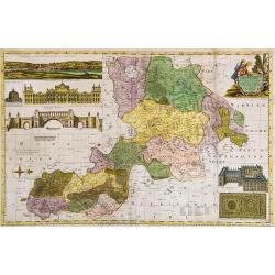
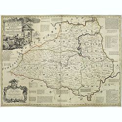
Northamptoniae Comitatus Descriptio.
This rare and important map is one of a series of county maps attributed to William Smith the antiquarian, each lacking the cartographer's name and consequently often ref...
Date: London, 1700
Selling price: ????
Please login to see price!
Sold in 2013
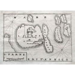
I. Farne.
A scarce map of the Farne Islands which are located off the coast of Northumberland! Published in Isole Britanniche. An apparently quite rare map, we can not find any oth...
Date: Venice, 1706
Selling price: ????
Please login to see price!
Sold in 2018
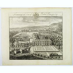
Stanway, the Seat of John Tracey Esq / Didmartin, the Seat of Robert Codrington Esq.
An attractive, and striking pair of early eighteenth century copperplate engravings of staely English homes, from Sir Robert Atkyn's The Ancient and Present State of Glou...
Date: London, ca 1712
Selling price: ????
Please login to see price!
Sold in 2018
Nieuwe Wassende Gradige Pas-kaart van een gedeelte der oost-kust van Engeland, Strekkende van Eckles tot Flambrouger Hooft , in zig begrypende de Rievier van Hull.
The successful van Keulen firm published charts, pilot guides and sea-atlases for over 2 centuries. Founded by Johannes van Keulen, his son Gerard led the firm to its zen...
Date: Amsterdam, 1715
Selling price: ????
Please login to see price!
Sold in 2011
Oxford Shire Actually Survey'd &c. . .
Scarce extensive county map, north oriented to the right. With an elaborate title cartouche, 5 inset views of "The Prospect of Oxford," "The Theatre,"...
Date: London, 1715
Selling price: ????
Please login to see price!
Sold in 2015
Hartfordshire.
This is an attractive and rare map of Hertfordshire.Copper engraving. Very attractive, uncommon map in good condition . Robert Morden's miniature maps are among the earli...
Date: London, 1720
Selling price: ????
Please login to see price!
Sold
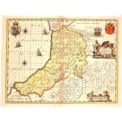
Ceretica Sive Cardiganensis Comnitatus;Anglis Cardigan Shire.
Splendid decorative map with two figurative, allegoric cartouches, two putti, three heraldic family coats of arms and three ships. A fine map of Cardigan Shire.
Date: Amsterdam, 1720
Selling price: ????
Please login to see price!
Sold in 2015
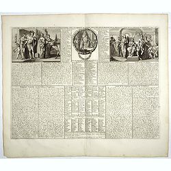
Carte des pr├®rogatives des rois et de la noblesse d'Angleterre . . .
Extracted from the historical atlas: introduction to the history, chronology, ancient and modern geography, genealogy of the royal houses of Europe with descriptive Frenc...
Date: Amsterdam, 1720
Selling price: ????
Please login to see price!
Sold in 2023
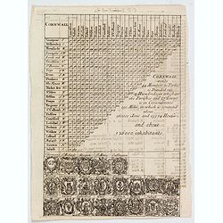
Cornwall.
A triangular distance table of Cornwall, with 21 sets of arms of the county and towns including Truro, St Ives & Fowey, with some statistics about the county. Publish...
Date: London, 1720
Selling price: ????
Please login to see price!
Sold in 2021
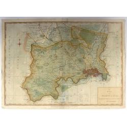
Nottinghamshire.
Detailed map of Nottingham with the early road system, cities & towns,lakes and rivers and forests and mountains. Adorned with an interesting title cartouche. Robert...
Date: London, 1722
Selling price: ????
Please login to see price!
Sold in 2014
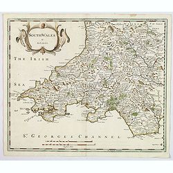
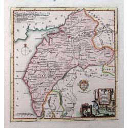
South wales.
A nice copper engraved map of South Wales, produced by Robert Morden for publication in Edmund Gibson's translation of William Camden's "Britannia", first publi...
Date: London, 1722
Selling price: ????
Please login to see price!
Sold in 2021
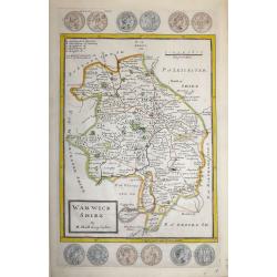
Warwick Shire by H. Moll Geographer
An interesting and attractive 18th century copperplate map of the county of Warwickshire divided into hundreds.It shows a title panel, scale and lists the administrative ...
Date: London, 1724
Selling price: ????
Please login to see price!
Sold in 2016
Academia Tertia Anglicana or The Antiquarian Annals of Stanford in Lincoln, Rutland, and Northampton Shires
First Edition of Peck's history of Stanford. Describing University, churches, schools of Stanford and several other places. Folding panorama frontis 'The Prospect of the ...
Date: 1727
Selling price: ????
Please login to see price!
Sold in 2010
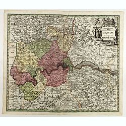
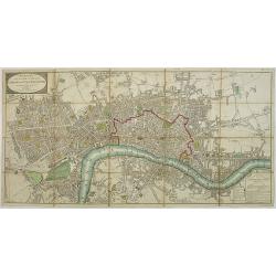
Delineatio ac finitima Regio Londini.
Centered on London, including towns of Hatfield, Tilbury, Walton on the Hill and Chertsey. Title in cartouche with royal arms, figure of Mercury, group of merchants. Boun...
Date: Ausburg, 1730
Selling price: ????
Please login to see price!
Sold in 2022
![[Untitled Martime Chart.]](/uploads/cache/43629-250x250.jpg)
[Untitled Martime Chart.]
One double page maritime chart from John Pine's Tapestry hangings of the House of Lords Representing the Engagements between the English and Spanish Fleets in the year 15...
Date: London, 1739
Selling price: ????
Please login to see price!
Sold in 2023
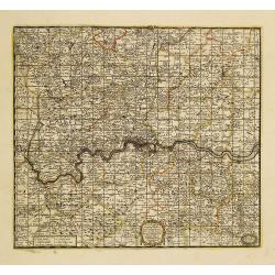
A New Map Containing the Towns Gentlemens Houses Villages and other Remarks Round London . . .
Detailed map showing hundreds of place names in the greater London area, including Darking, Hampsted, Hertford, Guildford, etc.
Date: London, 1740
Selling price: ????
Please login to see price!
Sold in 2011
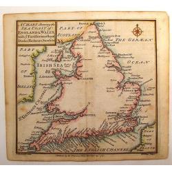
A Chart Shewing the Sea coast of England & Wales.
A fine map drawn by Thomas Badeslade and engraved by William Henry Toms which was published in the atlas "Chorographia Britannia". Thomas Badeslade (active 172...
Date: London, 1742
Selling price: ????
Please login to see price!
Sold in 2013
Cambridgshire?
Rare. From the Johan and Henry Overton's edition of John Speeds "Theatre of the Empire of Great Britain". Apart from 4 editions of the Atlas, published between ...
Date: London, 1710-1743
Selling price: ????
Please login to see price!
Sold
Roy.me d'Angleterre..
Nice small map of England, dated 1748. From Atlas Portatif Universel, by Robert de Vaugondy.Page 5 outside border top left.
Date: Paris, 1748
Selling price: ????
Please login to see price!
Sold
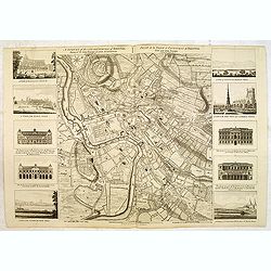
A Survey of the City and Suburbs of Bristol Survey'd by John Rocque Land Surveyor at Charing Cross, 1750 / Plan de la Ville et Faubourgs de Bristol Leve par Jean Rocque a Charing Cross a Londres 1750
Rare "carte ├Ā figures"- map of Bristol by J. Rocque.A large and detailed copper engraved map of the city and suburbs of Bristol, draw, surveyed and published b...
Date: London, 1750
Selling price: ????
Please login to see price!
Sold in 2012
![[An untitled Sea Chart of South Devon.]](/uploads/cache/46633-250x250.jpg)
[An untitled Sea Chart of South Devon.]
A large scale English Sea Chart of part of southern Devon in SW England. The chart is dominated by a very decorative dedication cartouche highlighting the landing of Will...
Date: London ca 1750
Selling price: ????
Please login to see price!
Sold in 2020
An accurate map of the county Palatine of Durham. . .
Scarce pre-atlas issue of 'The Large English Atlas' map of County Durham, published by John Hinton in 1751. Decorative cartouche around the title. Important and influenti...
Date: London, 1751
Selling price: ????
Please login to see price!
Sold in 2017
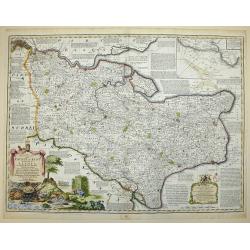
AN ACCURATE MAP OF THE COUNTY OF KENT DIVIDED INTO ITS LATHES, and Subdivided into Hundreds. Drawn from Surveys, and most approved modern Maps, with various additional Improvements: Illustrated with Historical Extracts relative to the Air, Soil, Natural P
A first edition pre Large Atlas. A large and handsome eighteenth-century map of the county on a scale of three-eighths of an inch to the mile.Compiled by Emanuel Bowen, G...
Date: London, 1751
Selling price: ????
Please login to see price!
Sold in 2017
Aftekening van het Margat.. / Afteekening van de Rivier Cly en Blakeny geleegen aan de Oostkust van Engeland..
Latitude scale, compass rose and system of rhumb lines, soundings, anchorage's, etc. A wealth of cities and information appear in the chart.
Date: Amsterdam 1753
Selling price: ????
Please login to see price!
Sold
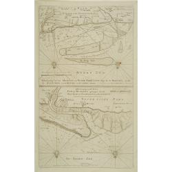
Afteekening van Scarbough Wicke.. / Afteekening van Hartlepoole ..
Latitude scale, compass rose and system of rhumb lines, soundings, anchorage\'s, etc. A wealth of cities and information appear in the chart.
Date: Amsterdam 1753
Selling price: ????
Please login to see price!
Sold in 2009
A new-enereasing Compass Map of part of the east coast of England..
Latitude scale, compass rose and system of rhumb lines, soundings, anchorage's, etc. A wealth of cities and information appear in the chart.The address is now updated to ...
Date: Amsterdam 1753
Selling price: ????
Please login to see price!
Sold in 2008
A new gradually encreasnig compass-map of the commingin of the Channel, or the Heads..
Title in Dutch, English and French. Showing the crossing of the Channel between Calais and Dover.Latitude scale, compass rose and system of rhumb lines, soundings, anchor...
Date: Amsterdam 1753
Selling price: ????
Please login to see price!
Sold
A new gradually encreasing compass-map, of a part the Sea Coasts of England .. Dorsetshire .. Hampshire ..
Title in Dutch and English. Showing the coasts of Dorset with Poole and Weymouth.Latitude scale, compass rose and system of rhumb lines, soundings, anchorage's, etc. In l...
Date: Amsterdam 1753
Selling price: ????
Please login to see price!
Sold
A new gradually encreasing compass-map, of a part the Sea Coasts of England .. Sussex .. Hastings to Arundel ..
Title in Dutch and English. Showing the coast of Sussex.Latitude scale, compass rose and system of rhumb lines, soundings, anchorage's, etc. In lower right corner with ad...
Date: Amsterdam 1753
Selling price: ????
Please login to see price!
Sold
An Accurate Map of Berkshire divided into its Hundreds . . .
A good clean copy of by far the most important eighteenth-century English atlas to be published before the appearance of John Cary's new English atlas in 1787 (Hodson). T...
Date: London ca 1756
Selling price: ????
Please login to see price!
Sold in 2023
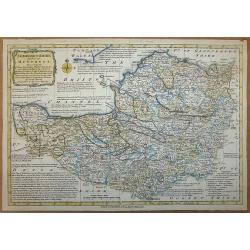
Cumberland, Drawn from the Best Surveys, Maps & Charts
An attractive and finely engraved 18th century map of Cumberland, by Thomas Kitchin, which was published in Henry Boswell's 'Antiquities of England & Wales'. It featu...
Date: London, 1762
Selling price: ????
Please login to see price!
Sold in 2016
Derbyshire Divided into Hundreds
A map of ŌĆśDerbyshireŌĆÖ by Emanuel Bowen and Thomas Bowen, ca. 1765.An extremely rare map from Thomas Kitchin's 1765 edition of the "English Atlas". Thomas Ki...
Date: London, 1765
Selling price: ????
Please login to see price!
Sold in 2017
L' Angleterre divises en 5 grandes Parties subsidivisees en 52 Comtes et partagee en 2 Provinces Ecclesiastiques.
Louis Brion de la Tour (1756-1823), ' Atlas G├®neral, Civil et Eccl├®siastique', 1766, ' Atlas G├®n├®ral', 1790-98. Louis Charles Desnos (fl.1750-70), Le Rouge's 'Atlas N...
Date: Paris, 1766
Selling price: ????
Please login to see price!
Sold in 2018
ŌĆśSomersetshire Divided into Hundreds'
An extremely rare map from Emanuel BowenŌĆÖs 'Atlas Anglicanus.'The maps for the Atlas Anglicanus were first issued in monthly parts, between 1767 and 1768, before the co...
Date: London, 1767
Selling price: ????
Please login to see price!
Sold in 2020
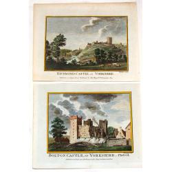
Bolton Castle & Richmond Castle in Yorkshire (2 Prints).
Two hand-covered, copper engravings taken from Francis Grose's "Antiquities of England and Wales" published in London by Alex Hogg. The engeravers were Thorton ...
Date: London, c1768
Selling price: ????
Please login to see price!
Sold in 2013
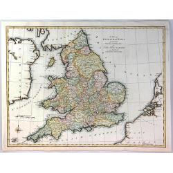
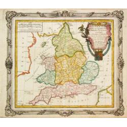
A Map of England and Wales from the Latest Authorities and Observations
A fine map of England and Wales by John Blair L.L.D. & F.R.S. issued as a Supplement to his Tables of Chronology. The Counties of England, and Wales are all separatel...
Date: London, 1773
Selling price: ????
Please login to see price!
Sold in 2018
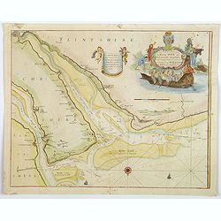
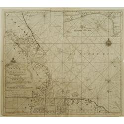
A New and Exact Survey of the River Dee or Chester-Water. . .
An English sea chart by Grenville Collins, depicting (in part) the coastlines and sands of The Wirral, Cheshire, Lancashire and Flintshire, and the River Dee estuary. The...
Date: London, ca 1774
Selling price: ????
Please login to see price!
Sold in 2020
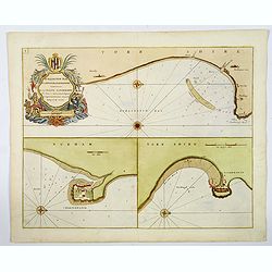
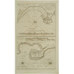
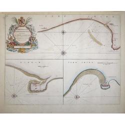
Burlington Bay, Scarborough & Hartlepool.
An impressive sea chart of the north England areas of Hartlepool, Scarborough and Burlington Bay. From Greenville Collins, the Hydrographer to the King (George III), from...
Date: London, ca 1774
Selling price: ????
Please login to see price!
Sold in 2019
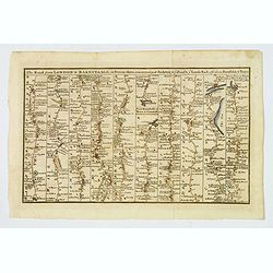
The Road from London to Barnstable, in Devonshire, commencing at Andover, in the road to the Lands End, also from Barnstable to Truro.
A highly detailed late eighteenth century road map, running left to right, commencing at Andover in Hampshire and continuing on to Barnstable in north Devonshire. The map...
Date: London, 1775
Selling price: ????
Please login to see price!
Sold in 2026
An Accurate Map of the County of Monmouth, Divided Into Hundreds
This attractive map of the county of Monmouth identifies major roads, villages, churches, and castles, it is by Emanuel Bowen, and was published for Robert Sayer in Londo...
Date: London, 1777
Selling price: ????
Please login to see price!
Sold in 2017
Provincia di Essex di nuova Projezione / Provincia di Middlesex di nuova Projezione. . .
Maps of Essex county (top) and Middlesex county (bottom), a former county, both located in the Southeast Greater London region by Antonio Zatta. The cities of Kingston an...
Date: Venice, 1779
Selling price: ????
Please login to see price!
Sold in 2010
Cumberland drawn from the best surveys,...
An attractive and finely engraved 18th century map of Cumberland. Main cities are shown connected with roads. Borough towns and market towns are indicated, as well as par...
Date: London, ca. 1780
Selling price: ????
Please login to see price!
Sold in 2016
Burlington Bay, Scarbrough & Hartlepoole - To Capt. Ralph Sanderson this chart is dedicated and presented by Capt. Greenvile Collins, Hydrogr. to the King
From Great Britain's Coasting Pilot, by Captain Greenville Collins, Hydrographer in ordinary to the King's most Excellent Majesty.This sea chart is divided into three vie...
Date: London, 1785
Selling price: ????
Please login to see price!
Sold in 2018
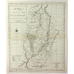
RUTLAND SHIRE, Drawn from the best Authorities
An attractive and neatly engraved 18th century map of Rutland, by Thomas Kitchin. It appeared in Henry Boswell's ŌĆ£Antiquities of England & WalesŌĆØ in London publis...
Date: London, 1786
Selling price: ????
Please login to see price!
Sold in 2016
A Map of Middlesex: Engraved from an Actual Survey, with Improvements.
Pleasant copper engraved, hand colored map of Middlesex and envrons. Engraved by Sudlow for John Harrison in London in 1787.
Date: London, 1787
Selling price: ????
Please login to see price!
Sold in 2016
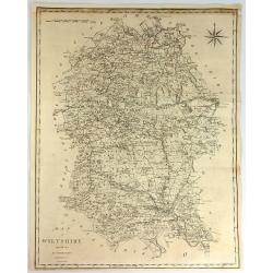
A Map of Wiltshire from the Best Authorities.
A fine and detailed map of the county of Wiltshire in Great Britain. It was engraved by John Cary. The map has a striking compass rose.John Cary (1754ŌĆō1835) was an Engl...
Date: London, 1787
Selling price: ????
Please login to see price!
Sold in 2017
A View, Accurate & Correct, Map of Nottinghamshire, Engraved From an Actual Survey
An uncommon, detailed map of Nottinghamshire, England from "Harrison's Atlas, Maps Of The English Counties", engraving by Haywood Sudlow. Although lacking decor...
Date: London, 1787
Selling price: ????
Please login to see price!
Sold in 2016

A Map of Hertfordshire, Engraved from an Actual Survey, with Improvements.
An uncommon late eighteenth-century map of the county - neatly engraved by Edward Sudlow (1784-1793). Originally produced as one of John Harrison's series of maps publish...
Date: London, 1788
Selling price: ????
Please login to see price!
Sold in 2016
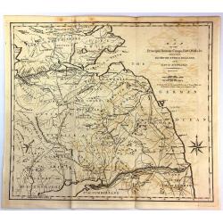
A Map of the Principal Roman Camps, Forts, Walls & c. Between the River Tyne in England and Tay in Scotland.
An antique county map published in "Britannia : or, a Chorographical Description of the flourishing kingdoms of England, Scotland and Ireland" by William Camden...
Date: London, 1789
Selling price: ????
Please login to see price!
Sold in 2016
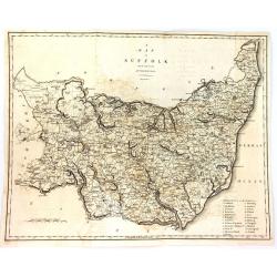
A Map of Suffolk from the Best Authorities.
An attractive and detailed late 18th century map of Suffolk engraved by John Cary and published in Richard Gough's new translation of Camden's Britannia (London: 1789). J...
Date: London, 1789
Selling price: ????
Please login to see price!
Sold in 2016
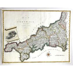
A Map of Cornwall from the Best Authorities
A fine map of Cornwall, in England by John Cary. Published in 'Camden's Britannia' in 1789. Interesting scroll insert featuring the Scilly Islands, with a fancy compass r...
Date: London, 1789
Selling price: ????
Please login to see price!
Sold in 2016
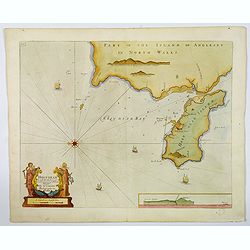
Holy-Head.
An impressive sea chart of Holy-Head in North Wales, from Greenville Collins, Hydrographer to the King (George III), taken from his Great Britain Coasting Pilot atlas. Th...
Date: London, ca 1790
Selling price: ????
Please login to see price!
Sold in 2020
Carte Particuliere des Costes Meridionales d'Angleterre Qui Comprend l'Isle de Wight, et le Havre de Portsmouth. . .
A superb, large sea chart of the Isle of Wight and the Dorsetshire and southern Hampshire coasts between Wareham in Dorset and Bosham in Hampshire.The marine chart includ...
Date: Paris, ca 1790
Selling price: ????
Please login to see price!
Sold in 2019
A New Map of Northhamptonshire & Cambridgeshire Drawn from the latest Authorities (Two maps on one page)
Two attached charming and detailed 18th Century county maps engraved by Thomas Condor for ŌĆ£The New And Complete English TravellerŌĆØ in London. Published by Alexander H...
Date: London, 1794
Selling price: ????
Please login to see price!
Sold in 2016
Wallis\'s Plan of the Cities of London and Westminster 1797.
First edition of this folding map covering Pentonville, Stepney, Lambeth and Hyde Park. Hand colored sections laid down on linen. Title on oval at top left. Explanation o...
Date: London, 1797
Selling price: ????
Please login to see price!
Sold in 2009
Parte Settentrionale Dell Inghilterra.
A fine Italian map of the northern part of England. It features a title cartouche "Siena 1795 Near Pazzini Carli". The sheet comes from the rare geographical At...
Date: Siena, 1798
Selling price: ????
Please login to see price!
Sold in 2020
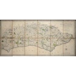
A Topographical Map of the County of Sussex Reduced from the Large survey in four sheets by Thomas Gream. . .
Folding Map of Sussex engraved on paper laid onto linen, with 6 folds, 380 x 800mm opened out, Scale: 6 miles to 2.5 inches. The map has original hand-coloring showing ...
Date: London, 1799
Selling price: ????
Please login to see price!
Sold in 2016
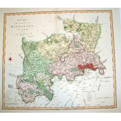
A New Map of the County of Middlesex.
A beautifully engraved and well-detailed turn of the 19th century map of County Middlesex, England. The metropolis of London and its environs are nicely highlighted, and ...
Date: London, dated 1801
Selling price: ????
Please login to see price!
Sold in 2008
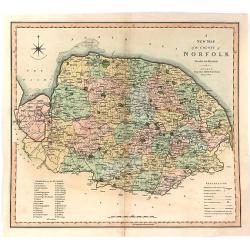
A New Map of the County of Norfolk Divided into Hundreds.
Large size, decorative map of the County of Norfolk by Jones, Smith & Co. for Smith's New English Atlas. The first map of the County to show longitudes measured from ...
Date: London, 1801
Selling price: ????
Please login to see price!
Sold in 2016
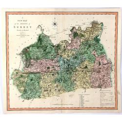
A New Map of the County of Surrey Divided Into Hundreds
A large sized, decorative map of the English County of Surrey by Jones, Smith & Co. for Smith's ŌĆ£New English AtlasŌĆØ. This is the first map of the County to show l...
Date: London, 1801
Selling price: ????
Please login to see price!
Sold in 2016
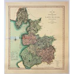
A New Map of the County Palatine of Lancaster Divided into Hundreds.
A large sized and decorative map of the county by Jones, Smith & Co. for Smith's "New English Atlas". The first map of the County to show longitudes measure...
Date: London, 1802
Selling price: ????
Please login to see price!
Sold in 2017
