Subscribe to be notified if similar examples become available.
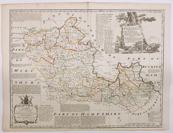
1756 BOWEN, E. - An Accurate Map of Berkshire divided into its Hundreds . . .
An Accurate Map of Berkshire divided into its Hundreds . . .
| Maker: | BOWEN, E. | |
| Date: | London ca 1756 | |
| Colored: | In original outline colors. | |
| Size: | 532 x 690 mm / 20.9 x 27.2 inches | |
| Condition: | In near mint condition. A few tiny pinholes. Wide margins, good impression, printed on strong thick paper. | |
 Add/Remove this item to MyCollection+




Description
The work was the first large scale atlas of English counties since the works of Blaeu and Jansson a century earlier and was based on the latest surveys available. The maps were a long time in preparation, the engraving work mostly shared between Emanuel Bowen and Thomas Kitchin, beginning in 1749 with the county of Sussex and reaching completion of 45 plates in 1760.
During this time the plates passed through the hands of several publishers and were issued individually and in part works without title. The Large English Atlas was issued by various publishers until 1794 with few changes to the maps.
This is an exceptional map of the county, brim full of interesting information and facts concerning this royal county, as seen in the mid 18th century. Because the scale is so large, the cartography is spread out, allowing for a better understanding of the general layout of the county.
In the lower right corner is an explanatory table for symbols used: Borough Towns, how many members of parliament are sent to Westminster, Rectories, Vicarages, Schools, Ancient Religious Houses, Post Stages, and Mileage circles are all there.
In additional many village , parks, roads hills etc are depicted. The map also lists notes on the Earls of Berkshire, and the Seats of The Nobility within the county. There are interesting textural notes concerning the towns of Abingdon, Windsor, Reading, Newbury, Hungerford and Wokingham.
Finally, this wonderful map is complemented with a huge title cartouche, featuring royal crowns and regalia, and a vignette of Windsor castle in the background, and a lovely dedication to the Duke of St. Albans (Lord Lieut. Of the County). This truly is the map to purchase if you have ever lived, or do live in Berkshire, or have any connection or affiliation to the county at all.
Emanuel Bowen (c. 1720-1767)
Emanuel Bowen was a London engraver, printseller, and publisher who produced some of the best and most attractive eighteenth-century maps. Although he earned recognition in both England and France and held the dual appointment as engraver to George II of England and Louis XV of France, Bowen died in poverty, nearly blind.FAQ - Guarantee - Shipping
Buying in the BuyNow Gallery
This item is available for immediate purchase when an "Add to Cart" or "Inquire Now" button is shown.
Payments are accepted in Euros or US Dollars. We accept most major credit cards, PayPal and bank transfer.
Authenticity Guarantee
 We provide professional descriptions, condition report and HiBCoR rating (based on 45 years experience in the map business).
We fully guarantee the authenticity of items we sell. We provide a certificate of authenticity for each purchased item.
Condition and Coloring
We indicate the condition of each item and use our unique HiBCoR grading system in which four key items determine a map's value:
Historical Importance, Beauty, Condition/Coloring and Rarity.
We offer many maps in their original black and white condition. We do not systematically color-up maps to make them more sellable to the general public or buyer.
Copper engraved or wood block maps are always hand colored. Maps were initially colored for aesthetic reasons and to improve readability.
Nowadays it is becoming a challenge to find maps in their original colors, and these are therefore more valuable.
We use the following color keys in our catalog:
- Original colors: the colors were applied around the time the map was issued.
- Original o/l colors: only the borders were colored at the time of publication.
- Colored: the colors were applied recently or at the end of the 20th century ("attractive colors" may also be used).
Read more about coloring of maps [+]
FAQ
Please have a look for more information about buying in the BuyNow gallery.
Many answers are likely to be found in the general help section.
MyCollection+

With MyCollection+ you can collect all your favorite items in one place. It is free, and anyone can create his or her virtual collection.
Unless you are logged in, the item is only saved for this session. You have to be registered and logged in if you want to save this item permanently.
Read more [+]
To save permanently, please
sign in or
create an account first.
Register here, it is free and you do not need a credit card.
Add this item to
MyCollection+
or see MyCollection+.
Invoice
Invoices and certificates of authenticity are available in the
client center > Invoices.
Paulus Swaen maintains an archive of most of our high-resolution rare maps, prints, posters and medieval manuscript scans.
We make them freely available for download and study.
Read more about free image download
Click the image for a free small image download.
YOUR RIGHT TO CANCEL THE PURCHASE OF A LOT
In accordance with the EU Consumer Rights Directive and habitually reside in the European Union you have the right to cancel the contract for the purchase of a lot, without giving any reason.
The cancellation period will expire 14 calendar days from the day after the date on which you or a third party (other than the carrier and indicated by you) acquires, physical possession of the lot. To exercise the right to cancel you must inform Paulus Swaen Inc, of your decision to cancel this contract by a clear statement (e.g. a letter sent by post, or e-mail.
To meet the cancellation deadline, it is sufficient for you to send your communication concerning your exercise of the right to cancel before the cancellation period has expired.
