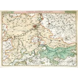
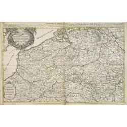
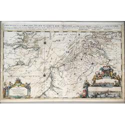
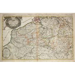
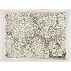
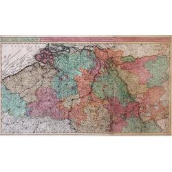
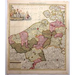
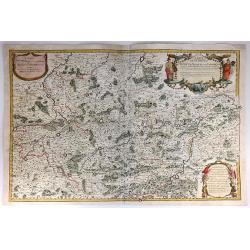
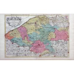
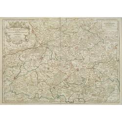
Leodiensis Episcopatus Pars Media, Comprehendens Hasbania Comitatum, Franchimontis Marchionatum, Stabulensem Principatum et Condrustum.
Fine map of the Liege region of Belgium including rivers, towns, and cities. The cities of Leige, Huy and Limburg are depicted.
Date: Amsterdam, 1690
Selling price: ????
Please login to see price!
Sold in 2010
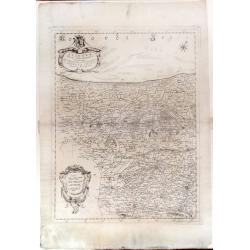
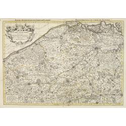
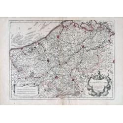
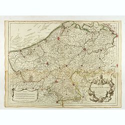
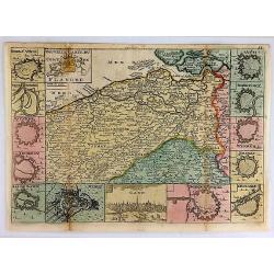
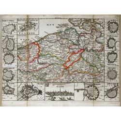
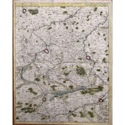
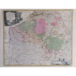
Fiandra parte occidentale: dedicata all\'illustrissimo et eccelententissimo S. Giorgio Cocco, senatore meritissimo. . .
Map of the northern part of Flanders divided between France and Belgium. From the North Sea south, including major cities along the coast such as Dunkerque, France and Oo...
Date: Venice, c. 1690
Selling price: ????
Please login to see price!
Sold in 2010
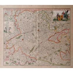
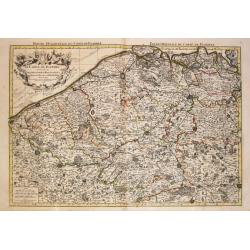
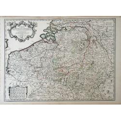
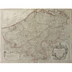
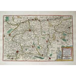
Comitatus Hnnoniae et Episcopatus Cambresis Descriptio.
Map of the Belgium province of Hainault or Henegouwen by Frederick De Witt depicting major cities such as Arte, Chimay and Philippeville and major rivers and forests in t...
Date: Amsterdam, 1690
Selling price: ????
Please login to see price!
Sold in 2010
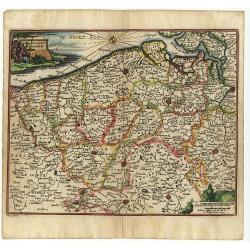
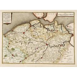
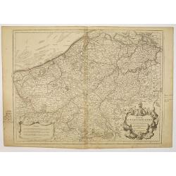
Comitatus Flandriae
Small map of the west part of Belgium locating major rivers and cities.
Date: Antwerp, 1692
Selling price: ????
Please login to see price!
Sold
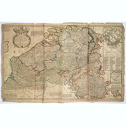
Les Provinces des Pays-Bas Catholiques . . . Le Roy de France, le Roy d'Espagne, et les Etats Généraux des Provinces-Unies . . .
Fine map of present day Belgium with a decorative title and scale cartouche.The map notes Nicolas Sanson as the mapmaker and claims that the map was published by Alexis-H...
Date: Amsterdam, 1692
Selling price: ????
Please login to see price!
Sold in 2015
Le Comte de Flandre divisé en ses Chastellenies et Balliages &c le Franc de Bruges et le Pays de Waes. . .
Fine map of the province of Flanders in present-day Belgium, ornated with a rococo title cartouche.Boundaries are outlined in hand color. The map is fully and richly engr...
Date: Amsterdam, 1692
Selling price: ????
Please login to see price!
Sold in 2023
Brusselles, Ville du Duché de Brabant et Résidence du gouverneur des Pays Bas espagnols.
A very decorative and extremely raretown-viewof Brussels, including a numbered key (1-21) in lower part. Engraved by Pierre-Alexandre Aveline. With "a Paris Chez Ave...
Date: Paris, ca.1692
Selling price: ????
Please login to see price!
Sold in 2014
Lyege, ville de la Seigneurie et de l'Evêché du même nom,. . .
A very decorative and extremely rare of Liege, including a numbered key (1-36) in lower part. Engraved by Pierre-Alexandre Aveline. With "Fait par Aveline Rue St.Ja...
Date: Paris, ca.1692
Selling price: ????
Please login to see price!
Sold in 2017
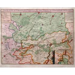
Nieuwe Kaart van't Graafschap Namen, met een Groot Gedeelte van't Hertogdom Brabant. . .
Map of Belgium with beautiful, vibrant original color. Shows military positions in the Siege of Namur by Louis XIV's French army during the Nine Years' War. An inset show...
Date: Amsterdam, 1692
Selling price: ????
Please login to see price!
Sold in 2010
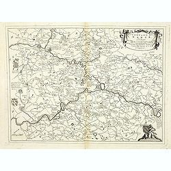
Estat et seigneurie de l'evesche de Lyege. . .
Fine map in the vicinity of Liège with a decorative title and scale cartouche.Alexis-Hubert Jaillot (1632-1712), was a French cartographer. He joined the Sanson heirs an...
Date: Amsterdam, 1692
Selling price: ????
Please login to see price!
Sold in 2011
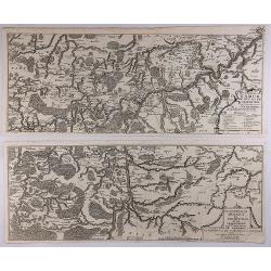
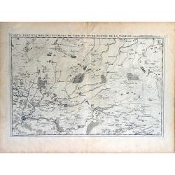
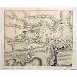
Carte Particuliere des Mouvements Faits et des Postes....
Map showing the terrain around Namur, Belgium showing the positions of the armies of France and those of the Confederate during the siege of Namur. Engraved by Cordier. ...
Date: Paris, 1692
Selling price: ????
Please login to see price!
Sold in 2018
Plan Des Lignes de L'Armee du Roy Devant la Ville de Chateau de Namur.
Map of the army fortifications of the King’s army in front of the Chateau de Namur in Belgium. The definition is very fine even to showing individual canons and ammunit...
Date: Paris, 1692
Selling price: ????
Please login to see price!
Sold in 2018
Carte Nouvelle des Costes de Hollande, Zeelande, Flandre, Picardie, & Normandie . . .
An impressive, large map of the Dutch, Belgian and English Coastlines, along with part of the English Channel by Romeyn De Hoogte, on two joined sheets. The extensive tit...
Date: Amsterdam, 1693
Selling price: ????
Please login to see price!
Sold in 2023
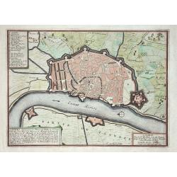
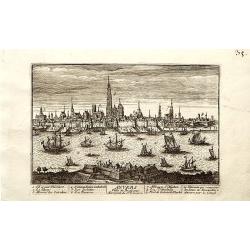
ANVERS, Antwerpen...
De Fer's scarce copper engraved plan of the foritified city and the surrounding area. Engraved by Harmanus van Loon. Shows the streets and city walls, the fields and road...
Date: Paris, 1695
Selling price: ????
Please login to see price!
Sold in 2011
Le Comte de Flandre / divise en ses / Chastellenies et Balliages &c / le Franc de Bruges et le Pays de Waes. A Paris, 1696.
Alexis-Hubert Jaillot (1632-1712), French cartographer. He joined the Sanson heirs and redrew Nicolas Sanson's maps on a larger scale. 'Atlas Nouveau' (1674), sea-atlas '...
Date: Amsterdam, 1696
Selling price: ????
Please login to see price!
Sold in 2010
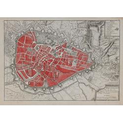
Anvers
Nice city plan of Antwerp.
Date: Paris 1696
Selling price: ????
Please login to see price!
Sold
Namur
Nice city plan of Namen.
Date: Paris 1696
Selling price: ????
Please login to see price!
Sold
Anvers
Nice city plan of Antwerp.
Date: Paris 1696
Selling price: ????
Please login to see price!
Sold
Conde
Small city plan of Conde with the fortification walls.
Date: Paris 1696
Selling price: ????
Please login to see price!
Sold
Sas de Gand
Small city plan of Sas van Gent with the fortification walls.
Date: Paris 1696
Selling price: ????
Please login to see price!
Sold
Maubeuge
Small city plan of Maubeuge with the fortification walls.
Date: Paris 1696
Selling price: ????
Please login to see price!
Sold
Les provinces des Pays-Bas Catholique. A Paris, 1696.
Alexis-Hubert Jaillot (1632-1712), French cartographer. He joined the Sanson heirs and redrew Nicolas Sanson's maps on a larger scale. 'Atlas Nouveau' (1674), sea-atlas '...
Date: Amsterdam, 1696
Selling price: ????
Please login to see price!
Sold in 2020
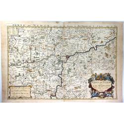
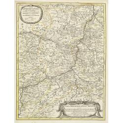
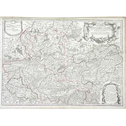
Comte de Namur Dresse sur les Memoires les Plus Nouveaux Presente a sa Majeste.
A fine, large, and detailed map of the area around the city of Namur in the province of Wallonia, in southern Belgium.From Jaillot’s “Nouvelle Introduction a le Geogr...
Date: Paris, 1696
Selling price: ????
Please login to see price!
Sold in 2017
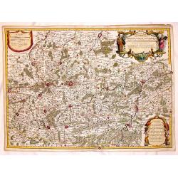
Le Comte de Haynaut Divise en Chattellenies Ballages Prevoste's & c.
A fine detailed map of the Haymaut region of Belgium. It spans the area between Chatellenie to Brabant. Printed from two joined plates, by Jaillot after Sanson. Alexis-Hu...
Date: Paris, 1696
Selling price: ????
Please login to see price!
Sold in 2018
Marchesato del sacro impero e signoria di Malines . . .
Large-folio map of the region around the Brabant cities of Leuven, Brussels, Mechelen, Antwerp and Dendermonde. Richly decorated with cartouches and coats of arms.Vincenz...
Date: Venice, 1696
Selling price: ????
Please login to see price!
Sold in 2020
Vesvocato di Liege. . .
A beautiful and flamboyantly engraved large-scale map of the region Liege, Maastricht, Hasselt in Belgium and the Nethermlands.In the lower left the title cartouche with ...
Date: Venice, 1698
Selling price: ????
Please login to see price!
Sold in 2019
Contado di Namur . . .
A beautiful and flamboyantly engraved large-scale map of Namur region in central Belgium. Includes several coats of arms.On verso a map of the Malay Peninsula as far sout...
Date: Venice, 1698
Selling price: ????
Please login to see price!
Sold in 2019
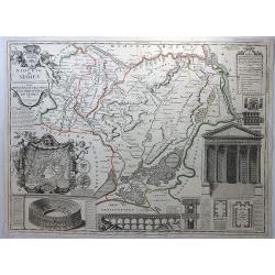
Diocese de Nismes.
A very busy map in the style of J.B. Nolan featuring Nismes in Belgium, and vignettes of its high points including the Amphitheatre, La Maison Quarrie, Temple de Dianne, ...
Date: Paris, 1698
Selling price: ????
Please login to see price!
Sold in 2018
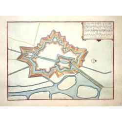
Plan du Fort de Rebus en Flandre.
A very fine map of the fortification of Rebus, in Flanders in northern Belgium. It features a drapery title cartouche and separate Information key.Nicolas de Fer (1646–...
Date: Paris, ca. 1700
Selling price: ????
Please login to see price!
Sold in 2017
Quartier de Louain???
Unique map of Brabant, Belgium. Louain or Louen or Leuven is the capital of the province of Flemish Brabant in Belgium. It is located about 25 kilometres east of Brussel...
Date: Brabant, ca. 1700
Selling price: ????
Please login to see price!
Sold in 2018
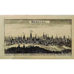
Brussel.
A miniature city view of Brussels, Belgium. It has a key to the main buildings along the bottom of the engraving. This print is not available now nor has been in the past...
Date: UNKNOWN, ca 1700
Selling price: ????
Please login to see price!
Sold in 2019
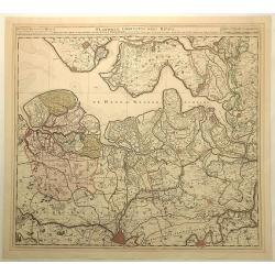
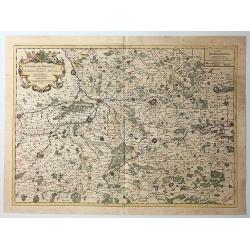
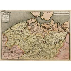
Flandriae Comitatus Pars Batava.
Fine detailed map of Flanders featuring the cities of Middleburg, Hulst, Dendermonde and Gent. It has very precise original coloring. By Visscher in Amsterdam.Nicolaes ...
Date: Amsterdam, c1700
Selling price: ????
Please login to see price!
Sold in 2020
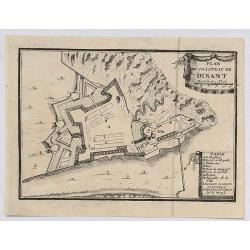
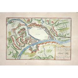
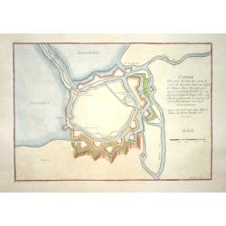
Plan du Chasteau de Dinant.
A plan of the castle of Dinant in Belgium, showing the fortifications. It features a ribbon decorative cartouche, and a detailed table of key places.
Date: Paris, ca 1700
Selling price: ????
Please login to see price!
Sold in 2020
Theatre de la Guerre dans les Pais-Bas, et Lieux circonvoisins, qui Represente les Electorates de Cologne, de Treves & de Mayence?
Detailed map showing northern French region of Champagne, Belgium and eastern Germany. Includes the cities of Frankfurt (on lower right edge), Luxembourg, Brugge, Brussel...
Date: Amsterdam, 1702
Selling price: ????
Please login to see price!
Sold in 2010
Carte des Pays Bas Catholiques. . .
Map of the Spanish, or Catholic Netherlands - a section of the Low Countries controlled by Spain from the 16th to 18th centuries. The map depicts areas from the Champagne...
Date: Paris, 1702
Selling price: ????
Please login to see price!
Sold in 2010
La Flandre espagnole, et la Flandre hollandoise..
Detailed map of Flanders distinguishing the part in the past under Spanish domination from that under Dutch domination. Showing Bruges, Gand, Antwerp.Engraved by F.Starck...
Date: Paris 1703
Selling price: ????
Please login to see price!
Sold
Flandriae Comitatus.
A scarce map of Belgium and neighbouring regions. With a decorative allegorical cartouche, with coat of arms, putti and queen. Published in Atlas Contractus Sive Mapparum...
Date: Amsterdam, 1703
Selling price: ????
Please login to see price!
Sold in 2018
![[Nine plans on a sheet] Winochs-Bergen - Aras of Atrecht - Bethune - Grevelingen - Gent - Aath - Ostende - Yperen - Condee.](/uploads/cache/48112-250x250.jpg)
[Nine plans on a sheet] Winochs-Bergen - Aras of Atrecht - Bethune - Grevelingen - Gent - Aath - Ostende - Yperen - Condee.
An attractive plate reuniting 9 city plans of Winochs-Bergen, Aras of Atrecht, Bethune, Grevelingen, Gent, Aath, Ostende, Yperen, Condee. Printed in red. Rare.
Date: Amsterdam, 1703
Selling price: ????
Please login to see price!
Sold in 2023
Carte du Comte de Flandre.
Guillaume de L'Isle map of Belgium, shows cities of Brugge and Antwerp.
Date: Paris, 1704
Selling price: ????
Please login to see price!
Sold in 2010
Carte du Comte de Flandre Dressee Sur Differens Morceaux LevezSur Les Lieux Fixez Par Les Obfervations A Aftonomiques.
A map of Flanders by Guillaume De L'Isle depicting major cities such as Conde and Altervelt, and major river systems. In the bottom right hand corner lies a very detailed...
Date: Paris, 1704
Selling price: ????
Please login to see price!
Sold in 2010
Carte du Comté de Flandre. . .
Map of Flanders. The publishers address in the title cartouche partly erased. Some manuscript annotations in brown pen and ink in the margin and in the map. Engraved by L...
Date: Paris, c.1704
Selling price: ????
Please login to see price!
Sold in 2010
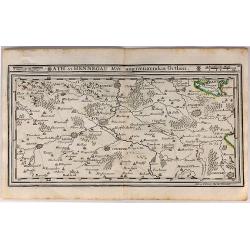
Ath in Hennegau Mitt Angeraenzenden Orthen.
An interesting map of the district of Ath, one of seven administrative districts within the Belgian province of Hainaut (southwest part). It was produced by Gabriel Boden...
Date: Augsburg, 1704
Selling price: ????
Please login to see price!
Sold in 2018
Carte du Comté de Flandre. . .
Map of Flanders, with the address : Chez l’Auteur sur le Quai de l’Horloge (address erased after Horloge). Avec privilege pour vingt ans, 1704." Guillaume de l'I...
Date: Paris, 1704
Selling price: ????
Please login to see price!
Sold in 2022
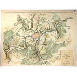
Les environs de NAMUR, de Huy et de Charle-roy..
Detailed map of the region of Namen, by Nicolas De Fer, who was a royal French geographer.
Date: Paris 1705
Selling price: ????
Please login to see price!
Sold
Les environs de DINANT, de Philippeville et de Charlemont..
Detailed map of the region of Dinant, by Nicolas De Fer, who was a royal French geographer.
Date: Paris 1705
Selling price: ????
Please login to see price!
Sold
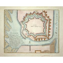
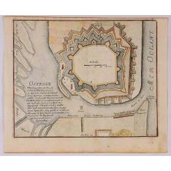
Ostende
Nice city plan of Oostende with the fortification walls and the port.
Date: Paris 1705
Selling price: ????
Please login to see price!
Sold
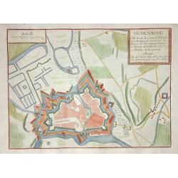
Oudenarde
Nice city plan of Oudenaarde.
Date: Paris 1705
Selling price: ????
Please login to see price!
Sold
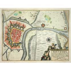
Nieuport
Nice city plan of Nieuport with the fortification walls and the river to the sea.
Date: Paris 1705
Selling price: ????
Please login to see price!
Sold
Winoxbergen.
Nice city plan of Winoxbergen in Flanders with the fortification walls.
Date: Paris 1705
Selling price: ????
Please login to see price!
Sold
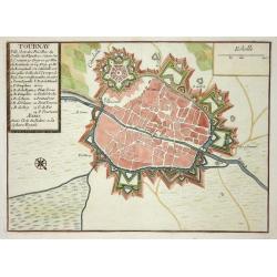
Tournay.
Nice city plan of Tournay in Flanders with the fortification walls and the citadel.
Date: Paris 1705
Selling price: ????
Please login to see price!
Sold
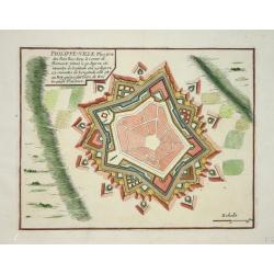
Philippe-ville.
Nice city plan of Philippe-Ville with the fortification walls.
Date: Paris 1705
Selling price: ????
Please login to see price!
Sold
La Flandre espagnole, et la Flandre hollandoise ...
Detailed map of Flanders distinguishing the part in the past under Spanish domination from that under Dutch domination, from De Fer's Atlas Curieux.Showing Bruges, Gand, ...
Date: Paris, 1705
Selling price: ????
Please login to see price!
Sold in 2009
Bruselles ...
Map of Brussels from De Fer's Atlas Curieux.
Date: Paris, 1705
Selling price: ????
Please login to see price!
Sold in 2010
Ostende Ville forte et port de Mer du Comte de Flandre.
A fine view of the fort of Ostende in Belgium. It was published in Paris in 1695.It was engraved by Harmanus van Loon and is from “Atlas Les Forces de le Europe”.Nich...
Date: Paris, 1705
Selling price: ????
Please login to see price!
Sold in 2018
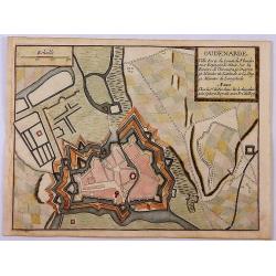
Oudenarde Ville Forte du Comte de Flandre.
A fine plan illustrating the important fortification of Oudenard in Belgium.Nicolas de Fer held the title of Geographer at Louis XIV's court. He was one of the most proli...
Date: Paris, 1705
Selling price: ????
Please login to see price!
Sold in 2019
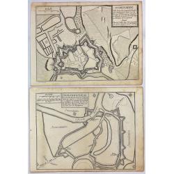
Dendermonde Ville Forte des Pas Bas, du Comte de Flandres & Oudenarde Ville Forte du Comte de Flandre. . .
Dendermonde and Oudenarde, Two (2) Low Country copperplate engravings of fortification cities from Flanders in Belgium, by De Fer in Paris in 1705. From "Les Forces ...
Date: Paris, 1705
Selling price: ????
Please login to see price!
Sold in 2019
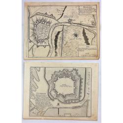
Ostende Ville Forte & Nieuport Port de Mer.
Ostende and Nieuport, Two (2) Low Country copperplate engravings of fortification cities from Flanders in Belgium. By De Fer in Paris in 1705. From "Les Forces de L'...
Date: Paris, 1705
Selling price: ????
Please login to see price!
Sold in 2019
Les Environs de Namur, de Huy et de Charle-Roy and Les Environs de Dinant, de Philippeville et de Charlemont (2 Maps).
Two matching maps of southern Belgium by N. de Fer in 1705. Each features a decorative title cartouche. They centre on the Namur and Dinant regions of Belgium.Nicolas de ...
Date: Paris , 1705
Selling price: ????
Please login to see price!
Sold in 2018
Nouvelle Carte Du Comte de Flandre.
An interesting map of Flanders first drawn by Daniel de la Feuille in 1706. A detailed map of the county of Flanders stretching from Dunkirk to the Schelde estuary. This ...
Date: Paris, 1706
Selling price: ????
Please login to see price!
Sold in 2018
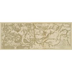
La Flandre Gallicane, Comprennant Le Chastellenie...
Small but very detailed map of the French and Belgian border region, with the fortified cites of Douai, Lille, Courtray, and Tournai. The map is embellished with an attra...
Date: Amsterdam, c1706
Selling price: ????
Please login to see price!
Sold in 2013
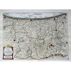
Partie de la Flandre Occidentale. . .
Very detailed map of western Flanders between Calais, Dunkerque, Omer, Ypres and Oostende. Shows many even smallest villages, roads, canals, settlements and fortification...
Date: Amsterdam, c1706
Selling price: ????
Please login to see price!
Sold in 2013
Nouvelle carte du Comte de Flandre.
A detailed map of the county of Flanders stretching from Dunkirk to the Schelde estuary. Surrounding the map are twelve towns plans: Berg St. Vinoc, Dendermonde, Ostende,...
Date: Amsterdam, 1706
Selling price: ????
Please login to see price!
Sold in 2013
Carte Particuliere des Environs de Lier et d'Une Partie de la Campine.
Interesting map of the region of northern Belgium surrounding the town of Lier, including the Walloon region of La Bruyere (Bruyere) and part of the Campine region of nor...
Date: Brussels, 1706
Selling price: ????
Please login to see price!
Sold in 2010
Carte des Comtez de Hainaut de Namur et de Cambresis. . .
Finely detailed map of the Walloon region, the regions of Hainaut, Namur and Cambresis, of southern Belgium by Guillaume de L'Isle. Cities, villages, rivers, forests and ...
Date: Paris, 1706
Selling price: ????
Please login to see price!
Sold in 2010
Carte des Comtez de Hainaut de Namur et de Cambresis.
Pleasing copper engraved, hand-colored map of Belgium and France featuring the cities of Douai, Landrecy, Namur, Brussels and Mons. Three decorative figural cartouches wi...
Date: Paris, 1706
Selling price: ????
Please login to see price!
Sold in 2016
Carte des Comtez de Hainaut de Namur et de Cambresis.
Striking copper engraved, hand-colored map of Belgium and France, featuring the cities of Douai, Landrecy, Namur, Brussels , Valencienes, and Mons.There are three decorat...
Date: Paris, 1706
Selling price: ????
Please login to see price!
Sold in 2018
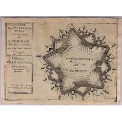
Citta Della Di Tournay.
The City of Tournay. This plate shows the fortifications of the Belgian city of Tournai (Doornik). The plate originates from 'Teatro della Guerra' by Coronelli in 1706.Vi...
Date: Venice, 1706
Selling price: ????
Please login to see price!
Sold in 2018
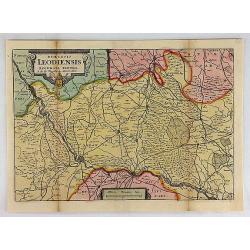
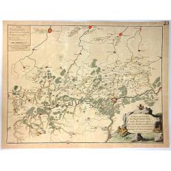
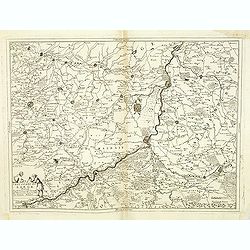
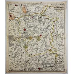
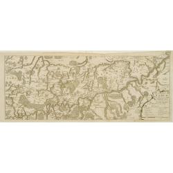
Diocesis Leodiensis Accurata Tabula.
A stunning map of Leodiensis, or the vicinity of Liege, Belgium, first drawn by Daniel de la Feuille in 1706. It depicts from Hoey in the west, eastwards as far as Peer, ...
Date: Paris, 1706
Selling price: ????
Please login to see price!
Sold in 2018
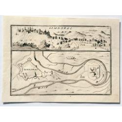
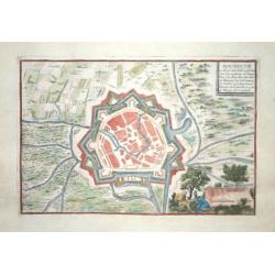
LIMBURGO.
An interesting simple city scene and map. This plate shows a view and a ground plan with fortifications of the Belgian city of Limbourg (Limburg). Vincenzo Coronelli (165...
Date: Venice, 1706
Selling price: ????
Please login to see price!
Sold in 2023
Le Comte de Flandre Divis en ses Chastellenies e Balliages?
Nicolas Sanson map of Belgium published by the Mortier publishing firm in Amsterdam with vibrant original color.
Date: Amsterdam, 1696-1708
Selling price: ????
Please login to see price!
Sold in 2010
Plan de la Bataille D'Oudenaerde.
A plan of the Battle of Oudenaerde fought on July 11th 1708. A finely engraved plan with excellent detail of the fortifications of Oudenaerde in Belgium. With a decorativ...
Date: Amsterdam, 1710
Selling price: ????
Please login to see price!
Sold in 2018
Theatre de la guerre en Flandres.
Unusual large-scale map of the French-Belgium border. Shows the area from Douai and Valenciennes to Ypres/Ieper and Courtrai/Kortrijk. Includes Roubaix, Lille, and Tourna...
Date: Brussels, 1712
Selling price: ????
Please login to see price!
Sold in 2014
Les Provinces des pays-Bas Catholiques. . .
This is an interesting map that can be dated to after the treaty of Utrecht (1712) as this was when Austria was given the Netherlands, and they are designated the 'Austri...
Date: London, ca 1716
Selling price: ????
Please login to see price!
Sold in 2017
Le Comté de Haynaut, Divisé en Chatellenies, Balliages, Prevostés. Le Cambresis. Dédié au Roy . . .
Map of the county of Hainaut with its most important cities, Mons (Bergen), Cambrai (Kamerijk) and Charleroi. Also including Hainaut, who territorially is divided between...
Date: Paris, 1720
Selling price: ????
Please login to see price!
Sold in 2010
Anvers.
A very RARE panoramic of Antwerp, including a numbered legend in both lower corners and several very fine ships.Published by the brothers Chéreau, active in Paris at ru...
Date: Paris, c. 1720
Selling price: ????
Please login to see price!
Sold in 2018
Arena Martis in Belgio qua Provincia x Catholica Inferioris Germania.
Homann map of northern France, Belgium and Holland - shows from Paris, France in the south up to Rotterdam, Holland in the north. Small inset view of Luttich (Liege, Beli...
Date: Nuremberg, 1720
Selling price: ????
Please login to see price!
Sold in 2010
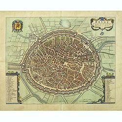
Bruge een der voornaamste steden van Vlaandren.
Detailed plan of Bruges from Flandria Illustrata . In lower right corner "Tom. II. No.37." and title now in Dutch and French, but not with the imprint of Covens...
Date: Amsterdam, 1720
Selling price: ????
Please login to see price!
Sold in 2011
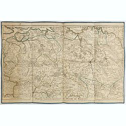
Partie septentrionale du duche de Brabant. . .
Detailed map prepared by Alex-Hubert Jaillot of the Dutch province of Brabant with the towns of 's-Hertogenbosch, Eindhoven, Helmond, Tilburg, Breda, etc. Also including ...
Date: Paris, 1720
Selling price: ????
Please login to see price!
Sold in 2015
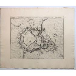
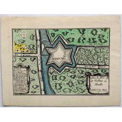
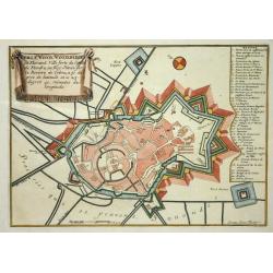
Plan de Menin, Fortresse de Flanders.
A striking map of the fortifications of Menen in West Flanders in Belgium. The map names buildings, ports, and other significant details, it also includes also roads, riv...
Date: Amsterdam, ca. 1720
Selling price: ????
Please login to see price!
Sold in 2019
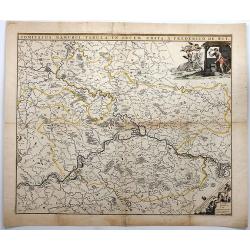
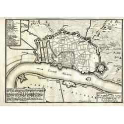
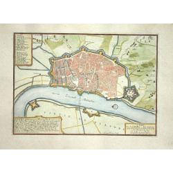
Comitatus Namurci TABULA IN Lucem.
A detailed map of Namur, Belgium centered on the Meuse River, published by the family of Frederick De Wit in about 1720.It includes a decorative cartouche featuring two b...
Date: Amsterdam, ca. 1720
Selling price: ????
Please login to see price!
Sold in 2018

