![Huum Opp. Condrusorum Caput. . . [Huy]](/uploads/cache/84184-250x250.jpg)
Huum Opp. Condrusorum Caput. . . [Huy]
A bird's-eye view of Huy by Braun and Hogenberg, with a key to locations. The 'Civitates Orbis Terrarum', or the "Braun & Hogenberg", is a six-volume town a...
Date: Cologne, 1575
Selling price: ????
Please login to see price!
Sold in 2020
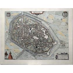
Mons, Hannonia Urbs PotenS & Ampla. . .
A bird's-eye view plan of Mons, by Georg Braun and Frans Hogenberg. From: 'Civitates Orbis Terrarum'. Liber tertius. Köln, G. Kempen, 1581-88. TRANSLATION OF CARTOUCHE T...
Date: Cologne, 1581
Selling price: ????
Please login to see price!
Sold in 2020
![Namurcum, Elegantissima ad Mosae Flume Civitas. [Namur]](/uploads/cache/84185-250x250.jpg)
Namurcum, Elegantissima ad Mosae Flume Civitas. [Namur]
A bird's-eye view plan of Namur by Braun and Hogenberg. CARTOUCHE: Namur, a very fair city on the River Meuse. COMMENTARY BY BRAUN: "The council for the whole county...
Date: Cologne, 1581
Selling price: ????
Please login to see price!
Sold in 2020
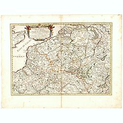
![[Flandria - Belgium]](/uploads/cache/32530-250x250.jpg)
[Flandria - Belgium]
On recto an early wood block printed map (115x153mm.) of Flanders in present-day Belgium. On verso a tiny view of Gent.From a Latin text edition of his Geographia, that g...
Date: Basle, 1550-1590
Selling price: ????
Please login to see price!
Sold in 2013
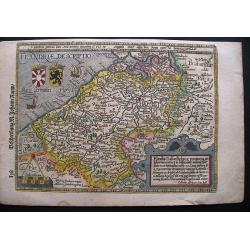
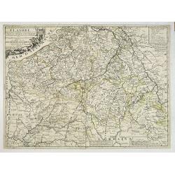
FLANDRIAE DESCRIPTIO.
A highly decorative and rare map of Flanders by Matthias Quad, published in the Cosmographia by Johann Rauw in 1597. On verso a woodcut plan of Brussels.
Date: Frankfurt, 1597
Selling price: ????
Please login to see price!
Sold in 2020
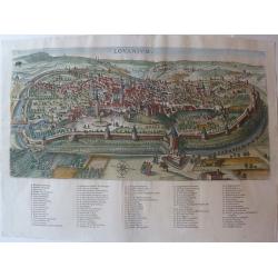
Lovanium.
A special and extremely rare engraving designed by the Leuven painter Joes vander Baren. It is about the Lovanium of Leuven engraving. Vander Baren had previously painted...
Date: Antwerpen, 1605
Selling price: ????
Please login to see price!
Sold in 2020
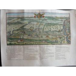
Heverlea.
A special and extremely rare engraving designed by the Leuven painter Joes vander Baren. This is the Heverlea engraving. The engraving was etched by Peeter vander Borcht ...
Date: Antwerpen, 1605
Selling price: ????
Please login to see price!
Sold in 2021
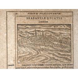
Louanium
Rare woodcut view of Louvain / Brabant. From "Parvum Theatrum Urbium sive Urbium Praecipuarum totius orbis Brevis & Methodica Descriptio" by Adrianus Romanu...
Date: Frankfurt, 1608
Selling price: ????
Please login to see price!
Sold in 2009
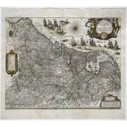
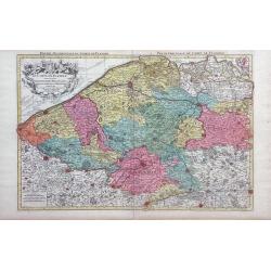
Novus XVII Inferioris Germaniae Provinciarum Typus
One of the most decorative maps of the Benelux countries. Title in a cartouche with Mercury and Mars at top right, with dedication and the name of 'Guliel. Blaeu'. Bottom...
Date: Amsterdam, 1630/1634
Selling price: ????
Please login to see price!
Sold in 2022
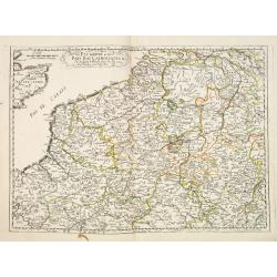
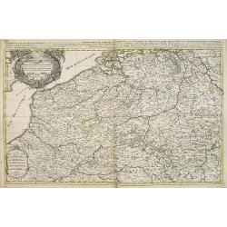
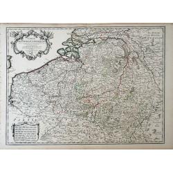
Picardie et les Pays Bas Catoliques &c. . .
Covering southern part of the Netherlands, Belgium and northern part of France. Engraved by R.Cordier Abbauil.Nicolas Sanson was to bring about the rise of French cartogr...
Date: Paris, 1667
Selling price: ????
Please login to see price!
Sold in 2014
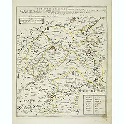
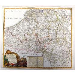
La Flandre Gallicane conquise par le Roy Lan c'est-à-dire La Province ou Chastellenie de Lille. . .
Scarce and detailed map of northern France, centered on Lille with title along the top. The map is dated 1667 and has the address "…proche le Fort l'Euesque, sur l...
Date: Paris, 1667
Selling price: ????
Please login to see price!
Sold
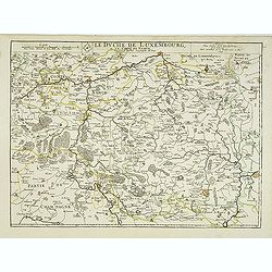
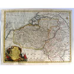
Le duche de Luxembourg et le comte de Namur . . .
The 1675 edition of the copperplate first issued in 1668. Detailed map of the duchy of Luxembourg and including the Belgium region Namur, with the title along the top.Dat...
Date: Paris, 1675
Selling price: ????
Please login to see price!
Sold in 2013
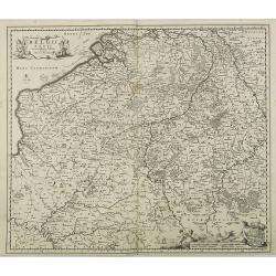
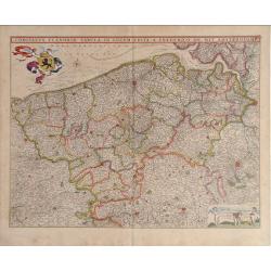
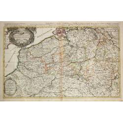
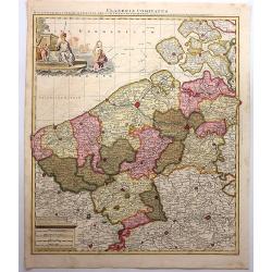
Belgii Regii accuratissima Tabula, Auctore Nicolao Visscher.
Map of mainly present-day Belgium. Taken from the atlas Germania Inferior, sive XVII Provinciarum Geographicae generales ut et particulares tabulae. Kaert-Boeck van de XV...
Date: Amsterdam, 16856-1677
Selling price: ????
Please login to see price!
Sold in 2015
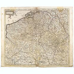
Belgii Regii Accuratissima Tabula Pluribus Locis. . .
Covering present-day Belgium, Luxembourg, Noord Brabant an Limburg in the Netherlands, and northern part of France.
Date: Amsterdam, 1680
Selling price: ????
Please login to see price!
Sold in 2023
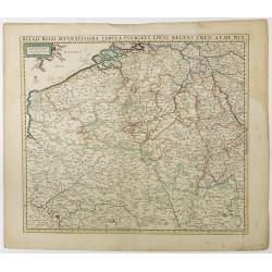
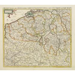
Belgii Regii Accuratissima Tabula Pluribus Locis recens emen: A F. DE Wit.
Covering present-day Belgium, Luxembourg, Noord Brabant an Limburg in the Netherlands, and northern part of France.
Date: Amsterdam, 1680
Selling price: ????
Please login to see price!
Sold in 2016
Belgii Regii Accuratissima Tabula Pluribus Locis...
Covering present-day Belgium, Luxembourg, Noord Brabant an Limburg in the Netherlands, and northern part of France.
Date: Amsterdam 1680
Selling price: ????
Please login to see price!
Sold in 2022
Comitatus Flandria Tabula, in Lucem Edita a Frederico de Wit Amsterdami.
Frederick de Wit map of Flanders region showing from Arras, France on the south to Antwerp, Belgium in the north with beautiful gold leaf detail.
Date: Amsterdam, 1680
Selling price: ????
Please login to see price!
Sold in 2010
Belgii Regii Tabula, in qua omnes Provincia ab Hispanis ad Annum 1684 possessae, nec nontam a Rege Galliea quam Batavis acquifitae. . .
Beautifully colored map of present day Belgium, northern France, Luxembourg and the Netherlands from Visscher's Germania Inferior. Paris and Luxembourg are shown in the s...
Date: Amsterdam, 1677-1684
Selling price: ????
Please login to see price!
Sold in 2010
Prouincie Meridionalide Paesi Bassi..
Rossi's map of Belgium and northern France and Luxembourg, based upon Sanson's map, but with revised Italian nomenclature. The engraver was Giorgio Widman.Issued in Il Me...
Date: Rome, 1677-1688
Selling price: ????
Please login to see price!
Sold in 2016
Fiandra parte occidentale: dedicata all\'illustrissimo et eccelententissimo S. Giorgio Cocco, senatore meritissimo. . .
Map of the northern part of Flanders divided between France and Belgium. From the North Sea south, including major cities along the coast such as Dunkerque, France and Oo...
Date: Venice, c. 1690
Selling price: ????
Please login to see price!
Sold in 2010
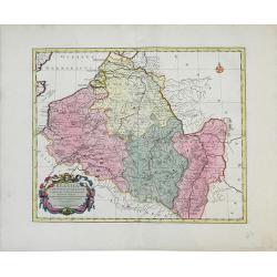
Comitatus Namurci Tabula.
Carol Allard map of Belgium, shows the city of Namur in the center.
Date: Amsterdam, 1690
Selling price: ????
Please login to see price!
Sold in 2010
La partie Meridionale des Pays-Bas, Connue sous le nom de FLANDRE divisée en plusieurs Provinces. . .
Although the title cartouche states Flanders, or the Spanish part of the 17 provinces of the Low Countries, the map shows present-day Belgium. Title cartouche on the uppe...
Date: Paris, 1690
Selling price: ????
Please login to see price!
Sold in 2022
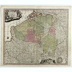
Comitatus Flandriae
Small map of the west part of Belgium locating major rivers and cities.
Date: Antwerp, 1692
Selling price: ????
Please login to see price!
Sold
Les Provinces des Pays-Bas Catholiques . . . Le Roy de France, le Roy d'Espagne, et les Etats Généraux des Provinces-Unies . . .
Fine map of present day Belgium with a decorative title and scale cartouche.The map notes Nicolas Sanson as the mapmaker and claims that the map was published by Alexis-H...
Date: Amsterdam, 1692
Selling price: ????
Please login to see price!
Sold in 2015
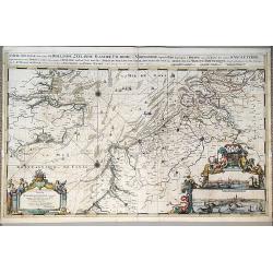
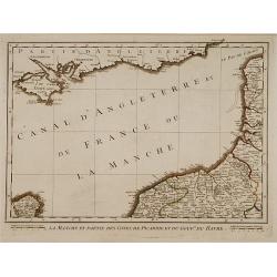
Carte Nouvelle des Costes de Hollande, Zeelande, Flandre, Picardie, & Normandie . . .
An impressive, large map of the Dutch, Belgian and English Coastlines, along with part of the English Channel by Romeyn De Hoogte, on two joined sheets. The extensive tit...
Date: Amsterdam, 1693
Selling price: ????
Please login to see price!
Sold in 2023
Les provinces des Pays-Bas Catholique. A Paris, 1696.
Alexis-Hubert Jaillot (1632-1712), French cartographer. He joined the Sanson heirs and redrew Nicolas Sanson's maps on a larger scale. 'Atlas Nouveau' (1674), sea-atlas '...
Date: Amsterdam, 1696
Selling price: ????
Please login to see price!
Sold in 2020
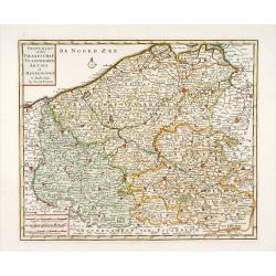
Theatre de la Guerre dans les Pais-Bas, et Lieux circonvoisins, qui Represente les Electorates de Cologne, de Treves & de Mayence?
Detailed map showing northern French region of Champagne, Belgium and eastern Germany. Includes the cities of Frankfurt (on lower right edge), Luxembourg, Brugge, Brussel...
Date: Amsterdam, 1702
Selling price: ????
Please login to see price!
Sold in 2010
Carte des Pays Bas Catholiques. . .
Map of the Spanish, or Catholic Netherlands - a section of the Low Countries controlled by Spain from the 16th to 18th centuries. The map depicts areas from the Champagne...
Date: Paris, 1702
Selling price: ????
Please login to see price!
Sold in 2010
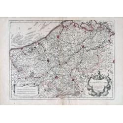
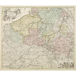
Flandriae Comitatus.
A scarce map of Belgium and neighbouring regions. With a decorative allegorical cartouche, with coat of arms, putti and queen. Published in Atlas Contractus Sive Mapparum...
Date: Amsterdam, 1703
Selling price: ????
Please login to see price!
Sold in 2018
Carte du Comte de Flandre.
Guillaume de L'Isle map of Belgium, shows cities of Brugge and Antwerp.
Date: Paris, 1704
Selling price: ????
Please login to see price!
Sold in 2010
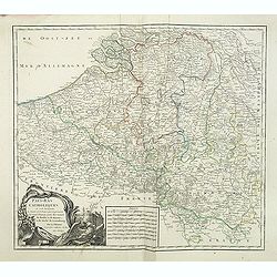
Carte des Comtez de Hainaut de Namur et de Cambresis.
Striking copper engraved, hand-colored map of Belgium and France, featuring the cities of Douai, Landrecy, Namur, Brussels , Valencienes, and Mons.There are three decorat...
Date: Paris, 1706
Selling price: ????
Please login to see price!
Sold in 2018
Le Comte de Flandre Divis en ses Chastellenies e Balliages?
Nicolas Sanson map of Belgium published by the Mortier publishing firm in Amsterdam with vibrant original color.
Date: Amsterdam, 1696-1708
Selling price: ????
Please login to see price!
Sold in 2010
Les Provinces des pays-Bas Catholiques. . .
This is an interesting map that can be dated to after the treaty of Utrecht (1712) as this was when Austria was given the Netherlands, and they are designated the 'Austri...
Date: London, ca 1716
Selling price: ????
Please login to see price!
Sold in 2017
Arena Martis in Belgio qua Provincia x Catholica Inferioris Germania.
Homann map of northern France, Belgium and Holland - shows from Paris, France in the south up to Rotterdam, Holland in the north. Small inset view of Luttich (Liege, Beli...
Date: Nuremberg, 1720
Selling price: ????
Please login to see price!
Sold in 2010
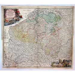
Arena Martis in Belgio, Qua Provincie X Catholica...
A detailed map of Belgium and parts of Holland, France and Germany, showing the territories occupied by the French, English, Dutch, Bavarians, and Prussians with a color ...
Date: Neuremberg, 1720
Selling price: ????
Please login to see price!
Sold in 2017
Carte du Comté de Flandre, suivant les nouvelles observations..
Including Belgium and Brabant. With decorative title cartouche lower right corner.
Date: Amsterdam 1728
Selling price: ????
Please login to see price!
Sold
Carte du Comté de Flandre, suivant les nouvelles observations..
Including Flanders and part of Brabant. With decorative title cartouche lower right corner with coat of arms, a farmer and a person weaving textiles.
Date: Amsterdam 1728
Selling price: ????
Please login to see price!
Sold
Carte du Comté de Flandre, suivant les nouvelles observations..
Including Belgium and Brabant. With decorative title cartouche lower right corner.This example is unusual in having the additional separately engraved decorative framewor...
Date: Amsterdam 1728
Selling price: ????
Please login to see price!
Sold
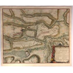
Plan de la Bataille D'Oudenaerde.
A plan of the Battle of Oudenard fought on July 11th 1708. A finely engraved plan with excellent detail of the fortifications of Oudenaerde in Belgium. Full hand coloring...
Date: Paris, 1729
Selling price: ????
Please login to see price!
Sold in 2018
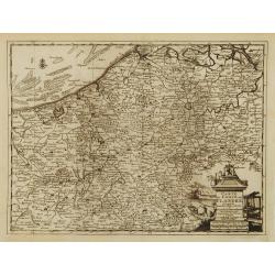
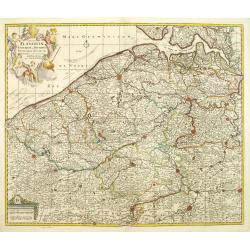
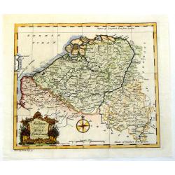
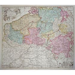
Belgica in Provincias Quatuor et Populos Viginti aut circiter. . .
This map, published by Covens and Mortier, covers present-day Belgium, once known as Belgica, and the surrounding provinces. In the 1st century AD, the provinces of Gaul ...
Date: Amsterdam, 1730
Selling price: ????
Please login to see price!
Sold in 2010
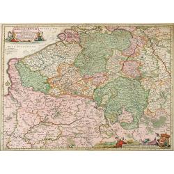
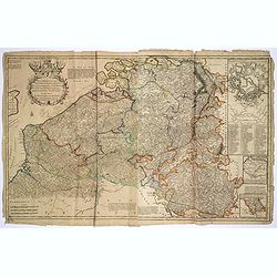
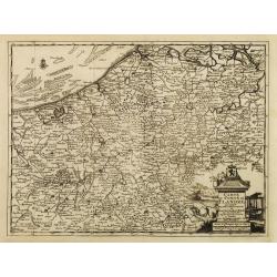
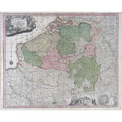
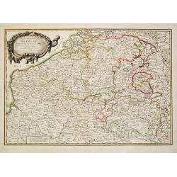
Germaniae Inferioris Sive Belgii Pars Meridionalis exhibens X. Provincias Catholi. Cum Confiniis Galliae Germ. Hollandiae recentissime et curatissime in lucem edita . . .
Decorative regional map of Belgium, centered on Namur. Inset plan of Oostende. Includes decorative cartouche. Shows cities and towns, place names, rivers and forests.Matt...
Date: Augsburg, 1730
Selling price: ????
Please login to see price!
Sold in 2018
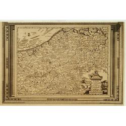
Belgii Regii accuratissima Tabula, Auctore Fredericum de Witt. . .ex Officina R. et J. Ottens.
Map of the present-day Belgium. Ottens acquired the copper plate from Visscher and re-issued the map, adding his address to the title cartouche. Uncommon.Joachim Ottens (...
Date: Amsterdam, 1730
Selling price: ????
Please login to see price!
Sold in 2010
![Kings of Brabant. [2 maps]](/uploads/cache/13016-250x250.jpg)
Kings of Brabant. [2 maps]
Two attractive engravings of the Brabant Dukes, from Tassandre the First till Philip V, published in the rare first edition of "Kleyne en Beknopte Atlas, of Tooneel ...
Date: Amsterdam 1735
Selling price: ????
Please login to see price!
Sold
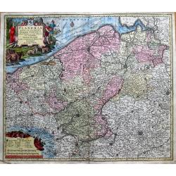
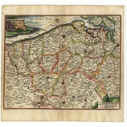
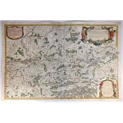
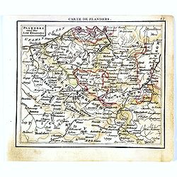
Flandria Maximus et Pulcherrimus Europae...
Large copper engraved map of Flanders in Belgium. Extends to include the borders of France, and the southern tip of the Netherlands. Shows the coastline from Grevelingen ...
Date: Augsburg, 1740
Selling price: ????
Please login to see price!
Sold in 2014
Comitatus Flandriae universe in ditiones. . .
Detailed map of Flandriae. Showing the cities of Lens, Lille, Bethune, Brugge, Gent. Beautiful title cartouche surrounded by 5 cherubs.
Date: Amsterdam, 1740
Selling price: ????
Please login to see price!
Sold in 2011
Germanie Inferioris Belgii.
Matthaus Seutter map of northern France, Belgium and Holland. Shows from Paris, France in the south to Rotterdam, Holland in the north.
Date: Augsburg, 1730-1740
Selling price: ????
Please login to see price!
Sold in 2010
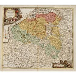
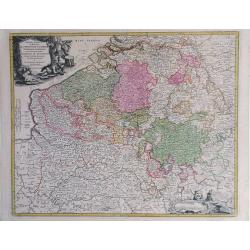
Arena Martis in Belgio qua provinciae X catholicae..
"Johann Baptist Homann's well-engraved map of Belgium, southern part of the Netherlands and Luxembourg. With two fine decorative title cartouche, one with miniature ...
Date: Neurenberg 1744
Selling price: ????
Please login to see price!
Sold
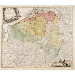
Arena Martis in Belgio qua provinciae X catholicae. . .
Johann Baptist Homann's well-engraved map of Belgium, southern part of the Netherlands and Luxembourg. With two fine decorative title cartouche, one with miniature panora...
Date: Neurenberg 1744
Selling price: ????
Please login to see price!
Sold in 2011
Cartes Des Provinces Des Pays Bas Contenant les Comte´s de Flandre, de Hainaut, Cambresis, le Duche´ de Brabant. . .
Fricx was a book seller and publisher active in Brussels. He issued maps from 1703 onwards and is best known for his maps of the military campaigns of the War of the Span...
Date: Paris, Crepy, 1744
Selling price: ????
Please login to see price!
Sold in 2014
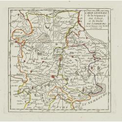
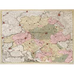
Carte Générale de la Seigneurie de Lyege, et du Duché de Limbourg.
Attractive small map showing an area straddling the border between the Netherlands, Belgium and Germany.Centered on Maastricht. Dated 1748. Divided into 6 sections. From ...
Date: Paris, 1748
Selling price: ????
Please login to see price!
Sold
Carte de la principauté de Liege et de ses environs..
Map of present-day Dutch and Belgium Brabant and Liege, with an imposing title cartouche Carte de la pricipauté de Liége et de ses environs tirée des observations fait...
Date: Liege, ca.1748
Selling price: ????
Please login to see price!
Sold
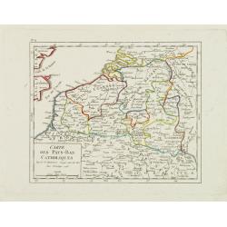
Carte des Pays-Bas Catholiques.
Nice small map that extends from Dieppe to Verdun and north into Holland. Dated 1748.From Atlas Portatif Universel, by Robert de Vaugondy.
Date: Paris, 1748
Selling price: ????
Please login to see price!
Sold in 2008
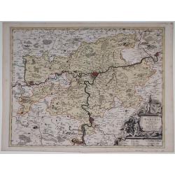
Nova et Accurata Hannonia Comitatus.
Detailed map of Belgium region centered around the city of Bergen Mons (Mons) in the center area of map. Also includes the cities of Douay (Douai), Valencienne and Brusse...
Date: Antwerp, 1720-1750
Selling price: ????
Please login to see price!
Sold in 2010
Pays-Bas Catholiques . . .
Detailled map of Belgium from his "Atlas Universel".Gilles Robert de Vaugondy (1688–1766), also known as Le Sieur or Monsieur Robert, and his son, Didier Robe...
Date: Paris, 1751
Selling price: ????
Please login to see price!
Sold in 2011
Pays-Bas Catholiques.
Nice, detailed, copper engraved map of the region of present day Belgium and Luxembourg. A fine military themed cartouche with a large fancy cartouche. Gilles Robert de V...
Date: Paris, 1751
Selling price: ????
Please login to see price!
Sold in 2015
A New & Accurate Map of the Netherlands or Low Countries.
Fine copper-engraved map with good detail of roads, towns, and canals. Also shown are the Barrier Towns as designated by the Barrier Treaty, concluded at Antwerp in 1715...
Date: London, 1752
Selling price: ????
Please login to see price!
Sold in 2018
Nieuwe kaart van het Graafschap Vlaanderen, Artois. . .
Detailed map of western part of present day Belgium. Published by Isaäk Tirion in deLuxe edition of "Handatlas der geheele Aarde", Amsterdam, 1753.
Date: Amsterdam, 1753
Selling price: ????
Please login to see price!
Sold in 2020
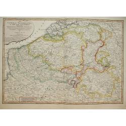
Austrian and French Netherlands.
Interesting copper engraved map featuring the Flanders and Brabant regions bordered by Luxemburg and Artois. Featuring a decorative Rococo title cartouche and a prominent...
Date: London, 1758
Selling price: ????
Please login to see price!
Sold in 2013
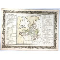
Description des Gaules Celtique et Belgique
A fine map of Gallic France and Belgium by Claude Buy de Mornas. It is from “Atlas Méthodique et Elémentaire de Géographie et l’ Histoire”, published in 1761.The...
Date: Paris, 1761
Selling price: ????
Please login to see price!
Sold in 2017
Flanders and the low Countries.
Uncommon miniature map of Belgium, engraved by Thomas Kitching for "A New General and Universal Atlas Containing Forty-five Maps by Andrew Dury." This miniature...
Date: London, 1761-1763
Selling price: ????
Please login to see price!
Sold in 2017
Sedes ac Theatrum Bellorum in Regionibus Rheni, Mosae ac Mosellae.
Striking, highly detailed copper engraved map of the Netherlands, Belgium and parts of Germany. Adorned with a large Rococo style double title and scale cartouche. The Lo...
Date: Augsburg, 1774
Selling price: ????
Please login to see price!
Sold in 2016
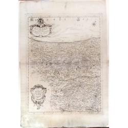
BELGIUM.
Map of the southern part of Belgium and the northern part of France. Brussels in the north, Mons in the south, Huy in the east and Tournay/Douai in the west.
Date: Paris 1781
Selling price: ????
Please login to see price!
Sold
Partie Méridionale des Pays Bas, Comprenant les Provinces de Brabant, Gueldre, Lumbourg, Luxembourg..
Attractive map centered on Belgium, encompassing Luxembourg, part of France and the southern part of the Netherlands.ornated with a decorative title cartouche. Boundaries...
Date: Paris, ca 1783
Selling price: ????
Please login to see price!
Sold in 2008
Partie Meridionale Des Pays Bas.
A pleasing example of Jean Janvier's 1783 decorative map of the southern portions of the Pays Bas, or Belgium and Luxembourg. It covers modern day Belgium and Luxembourg,...
Date: Paris, 1783
Selling price: ????
Please login to see price!
Sold in 2018
Partie Meridionale des Pays Bas Comprenant les provinces de brabant, Gueldre, Limbourg, Luxembourg, Haynaut, Namur, Flandre, Cambresis et Artois.
A map of Belgium and Luxembourg. Embellished with an attractive title-cartouche.
Date: Paris, 1785
Selling price: ????
Please login to see price!
Sold in 2010
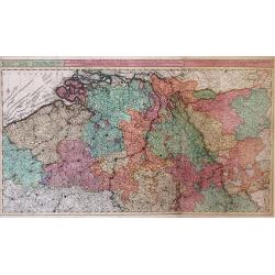
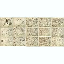
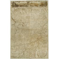
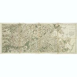
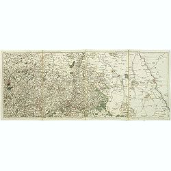
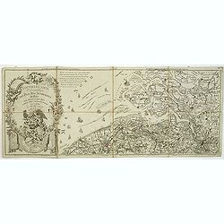
Nouvelle carte chorographique des Pays-Bas autrichiens.
COMPLETE Wall map of the Southern Low Countries (or Austrian Netherlands) published in 1789, composed of 16 leaves, each map ca. 320x395mm. and bound together.First map w...
Date: Bruxelles, 1789
Selling price: ????
Please login to see price!
Sold
Pays Bas françois et Autrichien..
Map of Belgium. With on verso a chart showing the coasts of the French Channel.Louis Capitaine (1749-1797) worked with Belleyme and Chanlaire on Topographical maps of Fra...
Date: Paris ca.1790
Selling price: ????
Please login to see price!
Sold
CARTE NOUVEUE DE PAIS BAS CATHOLIQUES
A detailed map showing Belgium and Luxembourg besides part of France. Probably printed from an old plate by De l'Isle with the imprint altered by Elwe.
Date: Amsterdam, 1792
Selling price: ????
Please login to see price!
Sold in 2015
The Netherlands.
Uncommon miniature map from Gibson's "Atlas Minimus, or a New Set of Pocket Maps of the several Empires, Kingdoms and States of the known World".
Date: London, 1792
Selling price: ????
Please login to see price!
Sold
Les environs de Namur, Dinant,. . .Les environs de SPA, Stavelot, . . .
Detailed map of Belgium, showing the cities of Namur, Dinant, Spa, Stavelot. The map was prepared by Jean Baptiste de Bouge (1757-1833), who prepared one of the first ver...
Date: Bruxelles, 1793
Selling price: ????
Please login to see price!
Sold in 2011
Les environs de Louvain, Tirlemont, . . . Les environs de Limbourg, Bolduc, . . .
Detailed map of Belgium. Showing the cities of Louvain, Liege, Diest, Maastricht and Aix la Chapelle, Cologne, etc. The map was prepared by Jean Baptiste de Bouge (1757-1...
Date: Bruxelles, 1793
Selling price: ????
Please login to see price!
Sold in 2011
Nouvelle carte chorographique des Pays Bas Autrichiens dédiée aux amateurs des arts. . .
Map of Belgium and Zeeland in the Netherlands. On the left a beautiful title cartouche with putti.The map was prepared by Jean Baptiste de Bouge (1757-1833), who prepared...
Date: Bruxelles, 1793
Selling price: ????
Please login to see price!
Sold in 2011
A New Map of the Seat of War in the Netherlands.
Large detailed map of Belgium, including parts of France, Luxembourg, Germany, and the Netherlands. Shows the status of the French Revolutionary Wars in 1794. Important m...
Date: London, 1794
Selling price: ????
Please login to see price!
Sold in 2012
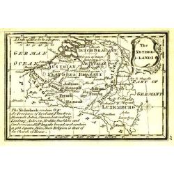
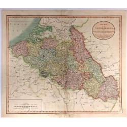
The Catholic Netherlands, or The Low Countries. Comprehending The Provinces of Brabant, Gelderland, Limburg, Luxemburg, Haynaut, Namur, Flanders, Cambre Sis & Artois by Samuel Dunn Mathematician.
A highly detailed map of the Netherlands by Samuel Dunn Published by R. Laurie & J. Whittle No 53 Fleet Street May 1794.
Date: London, 1794
Selling price: ????
Please login to see price!
Sold in 2014
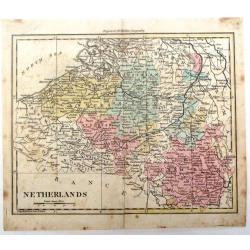
Netherlands.
Detailed map of the Netherlands by William Darton Jr. It is from Walker's Geography and is decorated with original coloring.
Date: London, 1802
Selling price: ????
Please login to see price!
Sold in 2016
A New Map of the Netherlands, Also Of that part of Germany Westward of the Rhine
A detailed map of John Cary’s Netherlands, from the important early 19th century “NEW UNIVERSAL ATLAS”. It covers from Dunkirk eastward as far as the German border....
Date: London, 1804
Selling price: ????
Please login to see price!
Sold in 2017
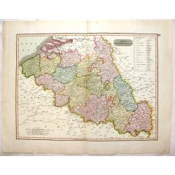
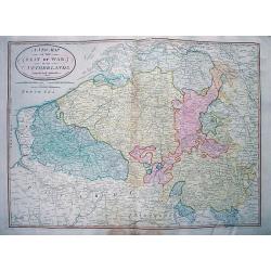
The Netherlands. (Belgium)
This striking hand colored 1814 Thomson map shows modern day Belgium, here called the Netherlands divided into thirteen departments. The labeled the Netherlands or “Low...
Date: Edinburgh, 1814
Selling price: ????
Please login to see price!
Sold in 2016
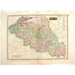
The Netherlands. (Belgium)
Striking, large map of Belgium here called The Netherlands divided into thirteen departments.John Thomson (1777-c1840) was a Scottish cartographer from Edinburgh, celebra...
Date: Edinburgh, 1814
Selling price: ????
Please login to see price!
Sold in 2016
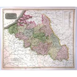
The Netherlands (Belgium and Luxemburg)
A fine map of Belgium and Luxembourg by John Thomson, the Edinburgh cartographer. The title ‘The Netherlands’ refers to the old name for Belgium. The map covers the r...
Date: Edinbourgh, 1817
Selling price: ????
Please login to see price!
Sold in 2016
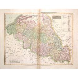
The Netherlands.
Striking large hand-colored map of The Netherlands. From John Thomson's "New General Atlas",/b> published in 1817. Engraved by J. Moffat.
Date: Edinburgh, 1817
Selling price: ????
Please login to see price!
Sold in 2018

