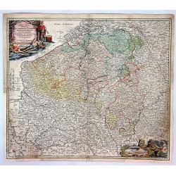
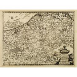
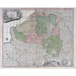
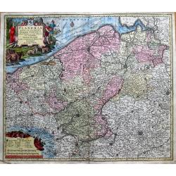
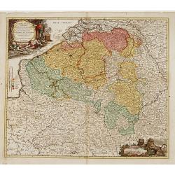
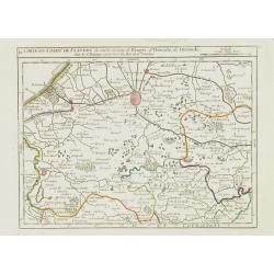
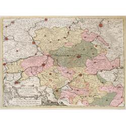
Arena Martis in Belgio, Qua Provincie X Catholica...
A detailed map of Belgium and parts of Holland, France and Germany, showing the territories occupied by the French, English, Dutch, Bavarians, and Prussians with a color ...
Date: Neuremberg, 1720
Selling price: ????
Please login to see price!
Sold in 2017
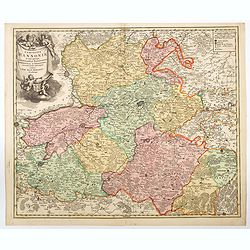
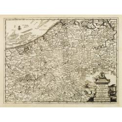
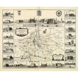
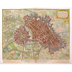
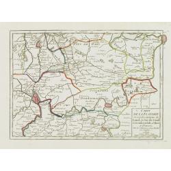
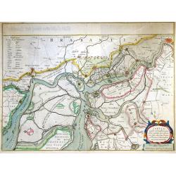
Comitatus Hannoniae in quas quasque Castellanias Balliviatus. . .
This beautiful and detailed map, is centered on the Belgian city of Mons, and includes the towns of Doornick, Halle, Charleroy, Camerijk and Dounay. The larger towns are ...
Date: Nuremberg, ca 1720
Selling price: ????
Please login to see price!
Sold in 2021
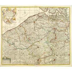
![Flandria et Zeelandia Comitatus. / A Map of the County of Flanders. [Two maps]](/uploads/cache/40598-250x250.jpg)
Flandria et Zeelandia Comitatus. / A Map of the County of Flanders. [Two maps]
[Two maps] First map is a decorative, large map including Flanders and Zeeland. The map, originally engraved in 1641 for Sanderus Flandria Illustrata, and was used at dif...
Date: Amsterdam, ca. 1645 - London, 1721
Selling price: ????
Please login to see price!
Sold in 2018
Carte du Comté de Flandre, suivant les nouvelles observations..
Including Belgium and Brabant. With decorative title cartouche lower right corner.This example is unusual in having the additional separately engraved decorative framewor...
Date: Amsterdam 1728
Selling price: ????
Please login to see price!
Sold
Carte du Comté de Flandre, suivant les nouvelles observations..
Including Belgium and Brabant. With decorative title cartouche lower right corner.
Date: Amsterdam 1728
Selling price: ????
Please login to see price!
Sold
Carte du Comté de Flandre, suivant les nouvelles observations..
Including Flanders and part of Brabant. With decorative title cartouche lower right corner with coat of arms, a farmer and a person weaving textiles.
Date: Amsterdam 1728
Selling price: ????
Please login to see price!
Sold
Carte du Comté de Flandre, suivant les nouvelles observations. . .
Including Flanders and part of Brabant. With decorative title cartouche lower right corner with coat of arms, a farmer and a person weaving textiles.
Date: Amsterdam, 1728
Selling price: ????
Please login to see price!
Sold in 2022
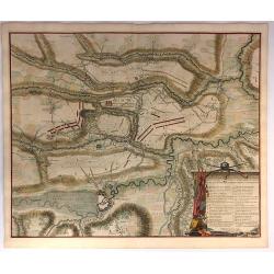
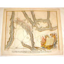
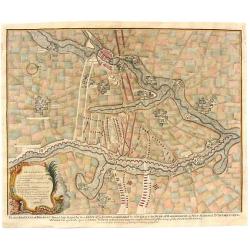
Plan der Glorieuse Veldslag van Malplaquet Gewonnen door de Geallieerde op den 11 September 1709.
Impressive large engraving, etching showing the battle of Malplaquet, published by Isaac van der Kloot after a design of Jan van Vianen (Amsterdam c. 1680 - after 1726).T...
Date: Amsterdam, 1729
Selling price: ????
Please login to see price!
Sold in 2014
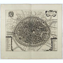
BRUGE een der voornaamste steden van Vlaandren / L'une desPrincipales Villes de Flandre. . .
Detailed plan of Brugge taken from the rare work "Histoire Militaire du Prince Eugene de Savoye, du Prince et Duc de Marlborough, et du Prince de Nassau-Frise" ...
Date: The Hague, Isaac van der Kloot, 1729
Selling price: ????
Please login to see price!
Sold in 2015
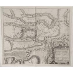
Plan de la Bataille D'Oudenaerde.
A plan of the Battle of Oudenard fought on July 11th 1708. A finely engraved plan with excellent detail of the fortifications of Oudenaerde in Belgium. Full hand coloring...
Date: Paris, 1729
Selling price: ????
Please login to see price!
Sold in 2018
Plan der Veldslag van Oudernaerde den 11 July, 1708 ...
Fine detailed plan of the fortifications of Oudenaarde in Belgium by Dumont in 1729. Engraved by James Basire. Features a striking title cartouche with weapons. James...
Date: Paris, 1729
Selling price: ????
Please login to see price!
Sold in 2023
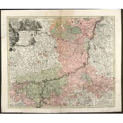
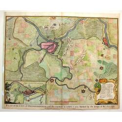
L'Eveche et L'Etat de Liege Avec les appartenances designées dans les pais voisins Delineation nouvelle et exacte Aux depens de Matthieu Seutter
Beautiful cooper engraved map of the central part of Belgium and parts of the Netherlands by M. Seutter. Showing the area around Liège and Maastricht. The nice...
Date: Augsburg, 1730
Selling price: ????
Please login to see price!
Sold in 2009
Belgii Regii accuratissima Tabula, Auctore Fredericum de Witt. . .ex Officina R. et J. Ottens.
Map of the present-day Belgium. Ottens acquired the copper plate from Visscher and re-issued the map, adding his address to the title cartouche. Uncommon.Joachim Ottens (...
Date: Amsterdam, 1730
Selling price: ????
Please login to see price!
Sold in 2010
Belgica in Provincias Quatuor et Populos Viginti aut circiter. . .
This map, published by Covens and Mortier, covers present-day Belgium, once known as Belgica, and the surrounding provinces. In the 1st century AD, the provinces of Gaul ...
Date: Amsterdam, 1730
Selling price: ????
Please login to see price!
Sold in 2010
Flandria Maximus Et Pulcherrimus Europae Comitatus in suas Ditiones accurate distinctus. . .
A fine impression of this decorative map with its uncolored title cartouche, showing Flanders including the towns of Gent, Sluis, Bruges, Ostend, Brussels, Lille, Dunkerq...
Date: Augsbourg, 1730
Selling price: ????
Please login to see price!
Sold in 2018
L'Eveche et l'Etat de Liege . . .
Detailed map centered on Liege. No text on verso. Very good impression done on thick paper.Matthaus Seutter the elder first published his "Atlas Geographicus" i...
Date: Ausburg, 1730
Selling price: ????
Please login to see price!
Sold in 2018
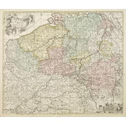
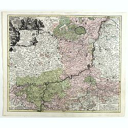
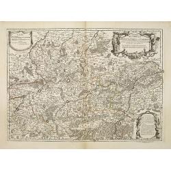
Germaniae Inferioris Sive Belgii Pars Meridionalis exhibens X. Provincias Catholi. Cum Confiniis Galliae Germ. Hollandiae recentissime et curatissime in lucem edita . . .
Decorative regional map of Belgium, centered on Namur. Inset plan of Oostende. Includes decorative cartouche. Shows cities and towns, place names, rivers and forests.Matt...
Date: Augsburg, 1730
Selling price: ????
Please login to see price!
Sold in 2018
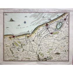
Carte Particulière des Environs de Dunkerque, Bergues, Furnes, Gravelines, Calais et autres.
A fine example of Covens & Mortier's regional map of the Belgian - French coastline showing; Dunkerque, Bergtues, Furnes, Gravelines, Calais and other cities. This at...
Date: Amsterdam, 1730
Selling price: ????
Please login to see price!
Sold in 2019
(Double page plan of Brussels)
Striking and highly detailed copper engraved city plan of Brussels, by Isaac Basire. For Mr. Tindal's Continuation of Mr. Rapin's History. This plan depicts roads, waterw...
Date: London, 1732
Selling price: ????
Please login to see price!
Sold in 2014

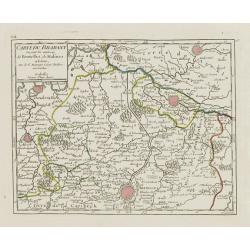
Kaart van 't graafschap Henegouwen.
Attractive map centred on the province of Cambrai and Mons, including two views of Mons and Valenciennes. Prepared by Daniel de La Feuille (1702) published in the rare fi...
Date: Amsterdam 1735
Selling price: ????
Please login to see price!
Sold
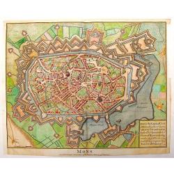
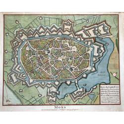
![Mons. [2 prints]](/uploads/cache/12979-250x250.jpg)
Mons. [2 prints]
Attractive birds-eye-view of the town of Mons and a map of the battle of 1709 in the area Mons and Maubeuge, with two fighting figures on the right side. Prepared by Dani...
Date: Amsterdam 1735
Selling price: ????
Please login to see price!
Sold
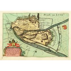
Luik.
An attractive birds-eye-view of the town of Liege, prepared by Daniel de La Feuille (1702) published in the rare first edition of "Kleyne en Beknopte Atlas, of Toone...
Date: Amsterdam 1735
Selling price: ????
Please login to see price!
Sold
![Kings of Brabant. [2 maps]](/uploads/cache/13016-250x250.jpg)
Kings of Brabant. [2 maps]
Two attractive engravings of the Brabant Dukes, from Tassandre the First till Philip V, published in the rare first edition of "Kleyne en Beknopte Atlas, of Tooneel ...
Date: Amsterdam 1735
Selling price: ????
Please login to see price!
Sold
Les Comtez de Hainaut, de Cambresis, et Partie du Comté de Namur..
Uncommon map showing southern Belgium provinces south of Brussels and published by Crepy.Including the towns of Lille, Brussels, Namen, Dinant, Cambray, Mons, etc.
Date: Paris, 1735
Selling price: ????
Please login to see price!
Sold in 2015
Nova et exacta tabula geographica Salae et Castellaniae Iprensis Anno MDCXXXXI
A "carte à figures"-map the Dioceses of Ypres, with the towns of Ypres and Roeselare. With a panoramic view of the town in top and 20 vignettes of buildings at...
Date: The Hague, Chr. Van Lom, 1732/1735
Selling price: ????
Please login to see price!
Sold in 2011
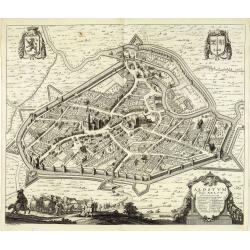
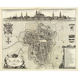
Alostum Vulgo Aelst.
Detailed plan of Aalst from Verheerlijkt Vlaanderen or Flandria Illustrata, engraved by R.Blokhuyse. The author was Antonius Sanderus [Anton Sander] (1586 -1664) who stud...
Date: The Hague, Chr. Van Lom, 1732/1735
Selling price: ????
Please login to see price!
Sold in 2011
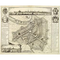
Teneramonda vulgo Dendermonde.
Detailed plan of Dendermonde from Verheerlijkt Vlaanderen or Flandria Illustrata, engraved by R.Blokhuyse. The author was Antonius Sanderus [Anton Sander] (1586 -1664) wh...
Date: The Hague, Chr. Van Lom, 1732/1735
Selling price: ????
Please login to see price!
Sold in 2011
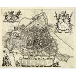
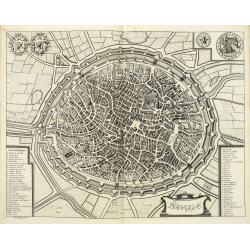
Gandavum Vulgo Gent.
Detailed plan of Gent from Verheerlijkt Vlaanderen or Flandria Illustrata, engraved by R.Blokhuyse. The author was Antonius Sanderus [Anton Sander] (1586 -1664) who studi...
Date: The Hague, Chr. Van Lom, 1732/1735
Selling price: ????
Please login to see price!
Sold in 2011
Ypra. (Ypre)
Detailed plan of Ypres from Verheerlijkt Vlaanderen or Flandria Illustrata, engraved by R.Blokhuyse. The author was Antonius Sanderus [Anton Sander] (1586 -1664) who stud...
Date: The Hague, Chr. Van Lom, 1732/1735
Selling price: ????
Please login to see price!
Sold in 2011
Brugge.
Detailed plan of Bruges from Verheerlijkt Vlaanderen or Flandria Illustrata, engraved by R.Blokhuyse. The author was Antonius Sanderus [Anton Sander] (1586 -1664) who stu...
Date: The Hague, Chr. Van Lom, 1732/1735
Selling price: ????
Please login to see price!
Sold in 2011
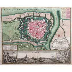
Novissima Ichnographica Delineatio munitissima Urbis et celeberrimi Emporii Ostenda, in Comitatu Flandria Austriaca fitae
Detailed city map of the city of Ostend, surrounded by walls and moats, on the coast of West Flanders, Belgium from Mathaus Seutter's Grosser Atlas. In the lower inset se...
Date: Augsburg, 1735
Selling price: ????
Please login to see price!
Sold in 2010
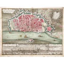
Plan de la Ville et Citadelle d'Anvers Renomee pour fon ports Comerce et edifices La citadelle est des plus fortes au monde, grave en taille douce
Detailed city map of the city of Anvers (now Antwerp), Belgium, surrounded by walls and moats, from Mathaus Seutter's Grosser Atlas. A view of the bustling port of Antwer...
Date: Augsburg, 1735
Selling price: ????
Please login to see price!
Sold in 2010
Germanie Inferioris Belgii.
Matthaus Seutter map of northern France, Belgium and Holland. Shows from Paris, France in the south to Rotterdam, Holland in the north.
Date: Augsburg, 1730-1740
Selling price: ????
Please login to see price!
Sold in 2010
Plan de la ville de Brusselle, Ville Noble au Duche de Brabant, et les delices des Pays Bas.
Impressive and scarce plan of Brussels by Covens & Mortier. This city plan was engraved by F. De Bakker and published in Amsterdam after 1712. The plan is a copy of t...
Date: Amsterdam, 1740
Selling price: ????
Please login to see price!
Sold in 2010
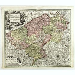
Comitatus Flandriae universe in ditiones. . .
Detailed map of Flandriae. Showing the cities of Lens, Lille, Bethune, Brugge, Gent. Beautiful title cartouche surrounded by 5 cherubs.
Date: Amsterdam, 1740
Selling price: ????
Please login to see price!
Sold in 2011
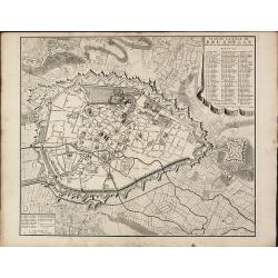
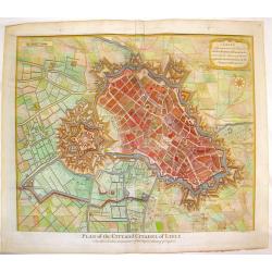
Mons, the Capital City of Hainault
City plan of Mons, Belgium during the time of the Treaty of Utrecht. From Mr. Tindal's Continuation of Mr. Rapin's "History of England".Paul de Rapin (1661-1725...
Date: Paris, 1740
Selling price: ????
Please login to see price!
Sold in 2015
Lisle, A Strong and Rich City in the Earldom of Flanders.
Elaborate bird's-eye view of the fortifications and city if Lille and the surrounding countryside.Decorated with a title cartouche and compass rose. Paul de Rapin (1661-1...
Date: London, 1740
Selling price: ????
Please login to see price!
Sold in 2015
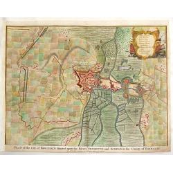
Plan of the City of Bouchaine.
"Plan of the City of Bouchain Situated Upon the Rivers Sensette & Sceld in the County of Hainault" For Mr. Tindal's Continuation of Mr. Rapin's 'HISTORY of ...
Date: London, 1740
Selling price: ????
Please login to see price!
Sold in 2015
Plan of the Towm & Castle of Lerida.
Striking copperplate engraving featuring the approaches made by the French and Spanish armies during the Spanish War of Succession. Lovely Rococco cartouche. Paul de Rap...
Date: London, 1740
Selling price: ????
Please login to see price!
Sold in 2016
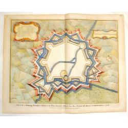
Aeth, A Strong Town in Brabant.
Fine copper engraved Fortification plan of Aeth, taken by the Duke of Marborough in 1706 during the Spanish War of Succession. Fancy Rococco cartouche. Nicholas Tindal (...
Date: London, 1740
Selling price: ????
Please login to see price!
Sold in 2016
Plan of the Glorious Battle of Hochstet.
Striking hand-colored copper engraving featuring the fortifications and troop placements during the Battle of Hochstet. Lovely flag cartouche. Nicholas Tindal (1687-1774...
Date: London, 1740
Selling price: ????
Please login to see price!
Sold in 2016
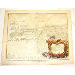
Plan of the Battle of Wynendale.
Copper engraved battle plan between Major General Webb and Count de la Motte with actual miniature pictures of the troupes. Very fancy Rococco cartouche with canons, flag...
Date: London, 1740
Selling price: ????
Please login to see price!
Sold in 2016
Lisle, A Strong and Rich City in the Earldom of Flanders.
Striking bird's-eye view of the fortification of the city of Lisle. Hand-colored, copperplate, detailed map with nice title cartouche and compass rose. Nicholas Tindal (...
Date: London, 1740
Selling price: ????
Please login to see price!
Sold in 2016
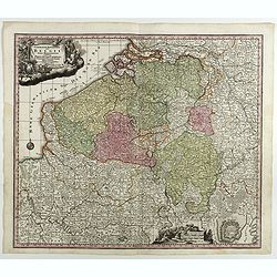
Flandria Maximus et Pulcherrimus Europae...
Large copper engraved map of Flanders in Belgium. Extends to include the borders of France, and the southern tip of the Netherlands. Shows the coastline from Grevelingen ...
Date: Augsburg, 1740
Selling price: ????
Please login to see price!
Sold in 2014
Plan of the Situation Where the Battle of Ramillies was Fought.
Battle Plan of the famous battle in 1706 in Flanders. Detailed cities as well as the battle. colored copper engraving. Nicholas Tindal (1687-1774) / Paul de Rapin (1661-1...
Date: London, 1742
Selling price: ????
Please login to see price!
Sold in 2016
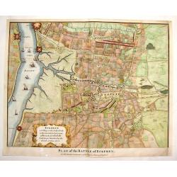
Plan of the Battle of Eckeren.
Detailed battle plan of the Battle of Eckeren. Belgium. Fancy Rococo cartouche and nine detailed ships in the harbour. Paul de Rapin (1661-1725) was a Frenchman responsi...
Date: London, 1743
Selling price: ????
Please login to see price!
Sold in 2014
Plan of the City of Dendermonde.
Copper engraved city plan of Dendermonde showing how allied troops blocked it. Nice Rococo cartouche. Paul de Rapin (1661-1725) was a Frenchman responsible for publishing...
Date: London - 1743
Selling price: ????
Please login to see price!
Sold in 2015
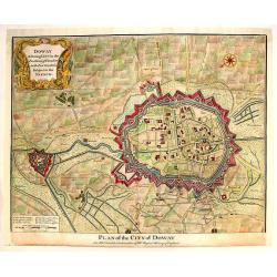
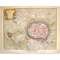
Doway, A Strong City in the Earldom of Flanders.
Copper engraved city plan of Douai from "History of England." Features the extensive fortifications and troop placements during the War of the Spanish Successio...
Date: London, 1743
Selling price: ????
Please login to see price!
Sold in 2015
Doway, A Strong City in the Earldom of Flanders. - Plan of the City of Doway.
Interesting copper engraved plan of the Fortification of Doway. Fancy Rococco cartouche. Nicholas Tindal (1687-1774)/ Paul de Rapin (1661-1725) was a Frenchman responsi...
Date: London, 1743
Selling price: ????
Please login to see price!
Sold in 2016
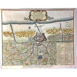
Dunkirk, A Strong Seaport Town in the Earldom of Flanders
A striking view of the walled city of Dunkirk with its extensive fortifications and surrounding countryside.A key at bottom left lists 40 important sites which are labele...
Date: London, 1743
Selling price: ????
Please login to see price!
Sold in 2020
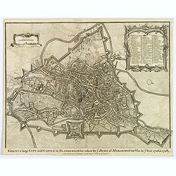
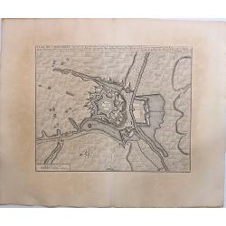
Ghent a large City and Castle in Flanders. . .
A very fine bird's-eye plan of the city and fortifications of Ghent and the surrounding countryside in Belgium. A decorative cartouche encloses a detailed key to the map ...
Date: London, 1743
Selling price: ????
Please login to see price!
Sold in 2019
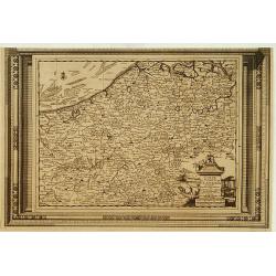
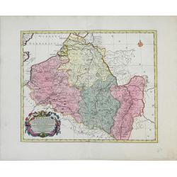
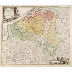
Arena Martis in Belgio qua provinciae X catholicae..
"Johann Baptist Homann's well-engraved map of Belgium, southern part of the Netherlands and Luxembourg. With two fine decorative title cartouche, one with miniature ...
Date: Neurenberg 1744
Selling price: ????
Please login to see price!
Sold
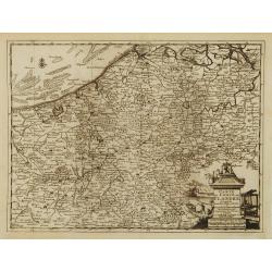
Arena Martis in Belgio qua provinciae X catholicae. . .
Johann Baptist Homann's well-engraved map of Belgium, southern part of the Netherlands and Luxembourg. With two fine decorative title cartouche, one with miniature panora...
Date: Neurenberg 1744
Selling price: ????
Please login to see price!
Sold in 2011
Cartes Des Provinces Des Pays Bas Contenant les Comte´s de Flandre, de Hainaut, Cambresis, le Duche´ de Brabant. . .
Fricx was a book seller and publisher active in Brussels. He issued maps from 1703 onwards and is best known for his maps of the military campaigns of the War of the Span...
Date: Paris, Crepy, 1744
Selling price: ????
Please login to see price!
Sold in 2014
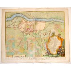
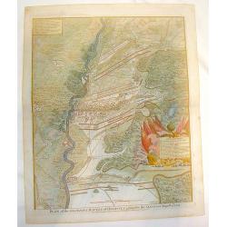
Plan of the Lines of Brabant forced July 18, 1705
This map of Brabant, Belgium is from Paul de Rapin's “The History of England” written in French by Mr. Rapin de Thoyras. The map represents a battle that took place d...
Date: London, 1744
Selling price: ????
Please login to see price!
Sold in 2023
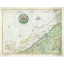
Carte Particuliere Des Environs D'Ostende Neuport Furnes et Autres
This is a seldom seen map of the coast of Belgium by one of the most prolific Belgian publishers of the 18th century, Eugène-Henri Fricx (1644-1740 c.). The map feature...
Date: Brussels, 1744
Selling price: ????
Please login to see price!
Sold in 2023
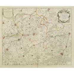
Carte des Comtéz de HAINAUT de NAMUR et de CAMBRESIS.
Map of the region of Mons, Maubeuge, Valencienes in the North of France and Namen and Huy in Belgium.Philippe Buache de la Neuville was born in Neuville-en-Pont (France) ...
Date: Paris, 1745
Selling price: ????
Please login to see price!
Sold in 2020
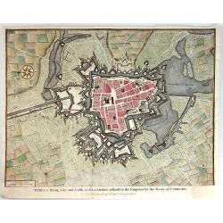
MONS the Capital City of Hainault in ye Low Countries, taken by ye French in 1691...
Superb bird's-eye plan of the city and fortifications of Mons. Beautifully illustrating the city with its buildings and churches in great detail. Also with two windmills,...
Date: London, ca. 1745
Selling price: ????
Please login to see price!
Sold in 2011
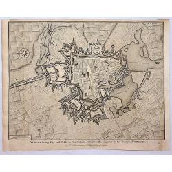
Ypres a Strong City and Castle in Flanders, Restored to the Emperor by the Treaty of Utrecht.
A fine and detailed view of the city of Ypres in Flanders as was included in Mr. Tindal's 'Continuation of Mr. Rapin's History of England'.
Date: London, 1745
Selling price: ????
Please login to see price!
Sold in 2016
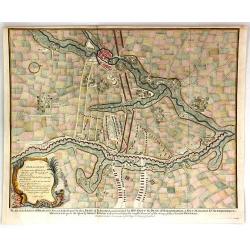
Plan of the Lines of Brabant Forced July 18, 1704 by the Army of the Allies
A detailed military map, engraved from 'Mr. Tindal's Continuation of Mr. Rapin's 'History of Engand'. With maps by Richard William Seale and John Basire, published by Rap...
Date: London, ca. 1745
Selling price: ????
Please login to see price!
Sold in 2019
Plan de Charleroy Ville Forte des Pays-Bas dans le Comte de Namur.
A striking example of Covens & Mortier's plan of Charleroy. The map focuses on the town fortifications and includes details of the town plan and environs.The primary ...
Date: Amsterdam, 1745
Selling price: ????
Please login to see price!
Sold in 2019
Ypres, a Strong City and Castle in Flanders.
A detailed plan of the City of Ypres, including fortifications, town plan, roads, farms, rivers, and a decorative compass rose. From Tindal's “Continuation of Rapin's H...
Date: London, 1745
Selling price: ????
Please login to see price!
Sold in 2018
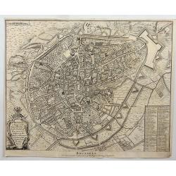
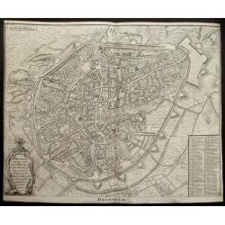
Brussels.
Fine detailed plan of the city of Brussels in Belgium, including fortifications, town plan, roads, farms, rivers and a decorative cartouche with arms, city crest and topp...
Date: London, 1746
Selling price: ????
Please login to see price!
Sold in 2018
Carte de la principauté de Liege et de ses environs..
Map of present-day Dutch and Belgium Brabant and Liege, with an imposing title cartouche Carte de la pricipauté de Liége et de ses environs tirée des observations fait...
Date: Liege, ca.1748
Selling price: ????
Please login to see price!
Sold
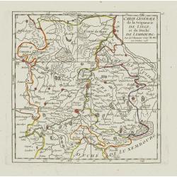
Carte Générale de la Seigneurie de Lyege, et du Duché de Limbourg.
Attractive small map showing an area straddling the border between the Netherlands, Belgium and Germany.Centered on Maastricht. Dated 1748. Divided into 6 sections. From ...
Date: Paris, 1748
Selling price: ????
Please login to see price!
Sold
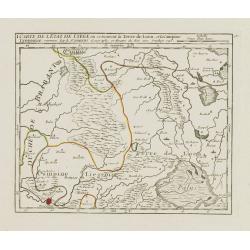
I. Carte de l'Etat de Lyege ou se trouvent la Terre de Leon, et la Campine Lyegeoise.
Attractive small map encompassing the eastern part of the Flemish Limburg. It shows the town of Diest in the lower left corner. Dated 1748.From Atlas Portatif Universel, ...
Date: Paris, 1748
Selling price: ????
Please login to see price!
Sold in 2022
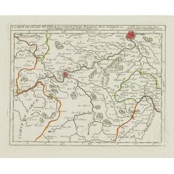
V. Carte de l\'Etat de Lyege.. ou se trouvent Lyege, Hannuye, Huy..
Attractive small map showing part of the Wallon region, south west of Liège. Dated 1748. From Atlas Portatif Universel, by Robert de Vaugondy.Page 15e outside border top...
Date: Paris, 1748
Selling price: ????
Please login to see price!
Sold in 2008
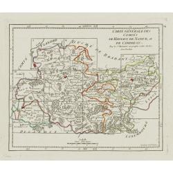
Carte Générale des Comtés de Haynaut, de Namur, et de Cambresis.
Attractive small map encompassing an area straddling the border between Belgium and France.Showing Cambrai, Tournai, Mons and Namur. Divided into 10 sections. From Atlas ...
Date: Paris, after 1748
Selling price: ????
Please login to see price!
Sold in 2008
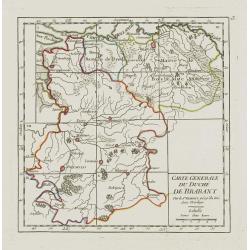
Carte Generale du Duché de Brabant.
Nice small map illustrating the Duchy of Brabant in the Low Countries. Divided into 10 sections. Centered on Herentals.The historical region consisted not only of the thr...
Date: Paris, later than 1748
Selling price: ????
Please login to see price!
Sold
![[IV.] Carte du Brabant où se trouvét la Mairie de Santhoven.. Ryen.](/uploads/cache/24684-250x250.jpg)
[IV.] Carte du Brabant où se trouvét la Mairie de Santhoven.. Ryen.
Nice small map encompassing an area which straddles the border between Belgium and the Netherlands.Showing Antwerp in the central lower part. From Atlas Portatif Universe...
Date: Paris, later than 1748
Selling price: ????
Please login to see price!
Sold in 2008
VII. Carte du Brabant ou sont les environs de Bruxelles, de Malines et Liere.
Nice small map illustrating part of the Flemish region and the Brussels-Capital Region. It shows Brussels, Aalst, Dendermonde, Mechelen and Lier.From Atlas Portatif Unive...
Date: Paris, later than 1748
Selling price: ????
Please login to see price!
Sold
![[VIII.] Carte du Brabant ou sont les env.s de Louvain, d'Ascot, de Diest de Leeuwe &c.](/uploads/cache/24688-250x250.jpg)
[VIII.] Carte du Brabant ou sont les env.s de Louvain, d'Ascot, de Diest de Leeuwe &c.
Nice small map illustrating part of the Flemish region. It shows Leuven, Aarschot, Diest and Sint-Truiden.From Atlas Portatif Universel, by Robert de Vaugondy. Unrecorded...
Date: Paris, later than 1748
Selling price: ????
Please login to see price!
Sold in 2022
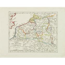
Carte des Pays-Bas Catholiques.
Nice small map that extends from Dieppe to Verdun and north into Holland. Dated 1748.From Atlas Portatif Universel, by Robert de Vaugondy.
Date: Paris, 1748
Selling price: ????
Please login to see price!
Sold in 2008
I. Carte du Comté de Flandre où sont les env.s de l'Ecluse, d'Ardenburg.. &c.
Nice small map illustrating the southwestern most part of Zeeland. Centered on Sluis. Showing Aardenburg and Vlissingen. Dated 1768.From Atlas Portatif Universel, by Robe...
Date: Paris, later than 1748
Selling price: ????
Please login to see price!
Sold in 2008
IV. Carte du Comté de Flandre où sont les environs de Bruges, d'Ostende, de Dixmunde.
Nice small map covering part of the West Flanders, delimited by Oostende, Bruges, Tielt, Roeselare and Diksmuide.From Atlas Portatif Universel, by Robert de Vaugondy. Unr...
Date: Paris, later than 1748
Selling price: ????
Please login to see price!
Sold in 2008
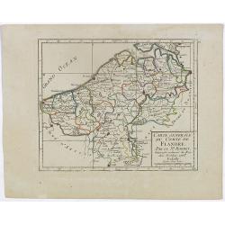
V. Carte de la Flandre où sont les environs de Gand.. et d'Anvers.
Charming small map covering part of the East Flanders, delimited by Ghent, Sas van Gent, Aalst, and Antwerp.From Atlas Portatif Universel, by Robert de Vaugondy. Unrecord...
Date: Paris, later than 1748
Selling price: ????
Please login to see price!
Sold in 2008
II. Carte du C.té de Haynaut où sont les environs de Halle, d'Enghien, de Braine le Comte.
Attractive small map encompassing part of Hainaut. It shows the towns of Enghien, Halle and Braine-le-Comte.From Atlas Portatif Universel, by Robert de Vaugondy.Unrecorde...
Date: Paris, after 1748
Selling price: ????
Please login to see price!
Sold in 2015
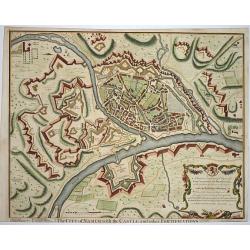
The city of Namur..
Nice fortification plan of the city Namur, with houses churches and even the gardens are visible. A decorative cartouche in the corner. Engraved by J. Basire.
Date: London ca. 1750
Selling price: ????
Please login to see price!
Sold
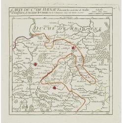
Nova et Accurata Hannonia Comitatus.
Detailed map of Belgium region centered around the city of Bergen Mons (Mons) in the center area of map. Also includes the cities of Douay (Douai), Valencienne and Brusse...
Date: Antwerp, 1720-1750
Selling price: ????
Please login to see price!
Sold in 2010
Tabula Castelli ad Sanflitam, qua fimul inundati agri, alluvio nes, fossae, alvei, quae Bergas ad Zomam et Anverpiam interjacent, annotantur. . .
Fine, beautifully colored map of the Antwerp region of Belgium. Fleets of ships are depicted sailing in and out of the city of Antwerp. The city of Bergen op Zoom is also...
Date: Amsterdam, c. 1750
Selling price: ????
Please login to see price!
Sold in 2010

