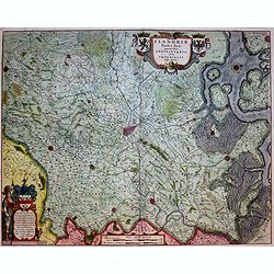
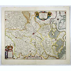
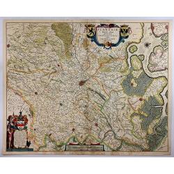
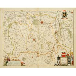
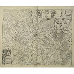
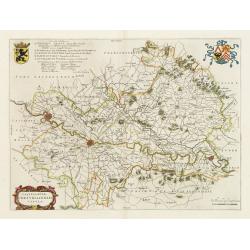
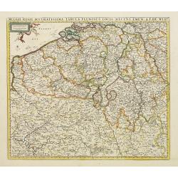
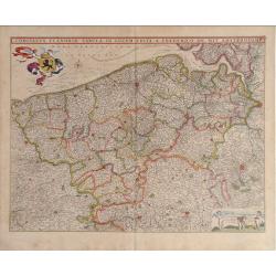
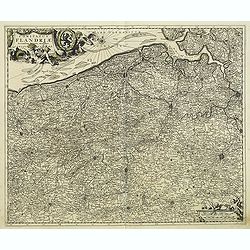
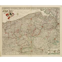
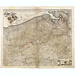
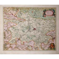
Flandriae Partes duae quarum altera proprietaria . . .
Splendid map of Flanders centered on Gent. in lower right corner Antwerp and Vlissingen in top right. At bottom left a very decorative cartouche with a dedication to Jaco...
Date: Amsterdam, ca. 1645
Selling price: ????
Please login to see price!
Sold in 2018
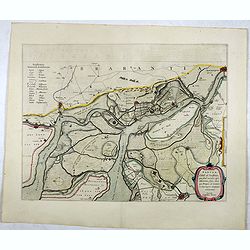
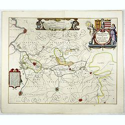
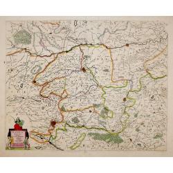
Tabula Castelli ad Sandflitam,..Bergas ad Zomam et Antverpi
East is at the top. The map pictures the complex military situation that had developed after the Dutch blockade of Antwerp. All entrenchment's and fortresses marked by a ...
Date: Amsterdam, 1645
Selling price: ????
Please login to see price!
Sold in 2017
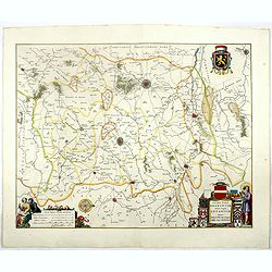
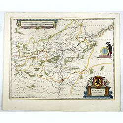
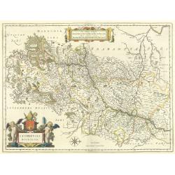
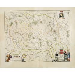
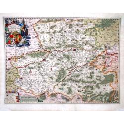
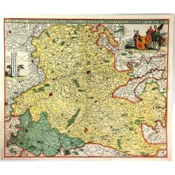
Prima pars Brabantiae cuius caput Lovanium.
Decorative map centered on Tienen and Leuven. West to the top.More about maps by Willem Blaeu. [+]
Date: Amsterdam, 1645
Selling price: ????
Please login to see price!
Sold
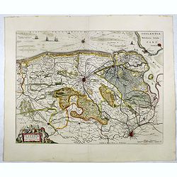
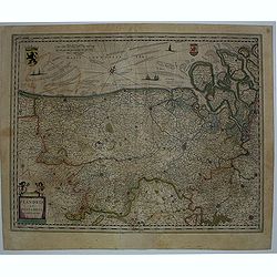
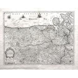
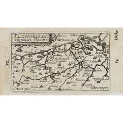
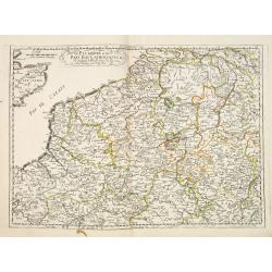
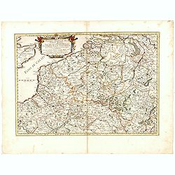
Flandriae Teutonicae pars orientalior.
Detail of the eastern part of Flemish Flanders: the Liberty of Bruges with the island of Cadzand. . . The towns of Ghent, Sluis, Bruges, Ostend and many others.More about...
Date: Amsterdam, 1645
Selling price: ????
Please login to see price!
Sold in 2020
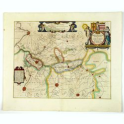
Flandriae Partes duae quarum altera proprietaria . . .
A very detailed map with Gent in the center. Lower right corner Antwerp and Vlissingen in top right. At bottom left a very decorative cartouche with a dedication to Jacob...
Date: Amsterdam, 1645
Selling price: ????
Please login to see price!
Sold in 2021
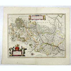
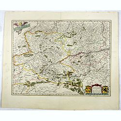
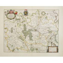
Secunda pars Brabantiae cuis urbus primaria Bruxellae . . .
At the upper left the title cartouche, decorated with two angels holding the heraldic arms of Brussels, Nijvel and Vilvoorde, next to it that of Brabant.More about maps b...
Date: Amsterdam, 1645
Selling price: ????
Please login to see price!
Sold in 2017
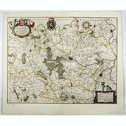
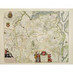
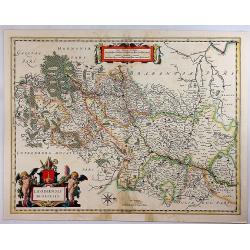
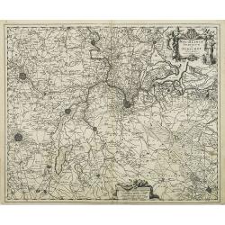
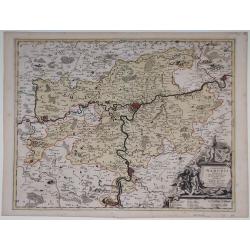
Mechlinia Dominium, et Aerschot Ducatus.
On the upper right a beautiful title cartouche embellished with two female figures of whom the one on the right is Justice. This splendid Blaeu map gives a survey of the ...
Date: Amsterdam, 1645
Selling price: ????
Please login to see price!
Sold in 2017
Leodiensis dioecesis.
West orientated to the top and a pair of fine cartouches to complement this fine Blaeu map including the Dutch province of Limburg and the Belgium province of Namen and A...
Date: Amsterdam, 1645
Selling price: ????
Please login to see price!
Sold in 2017
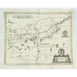
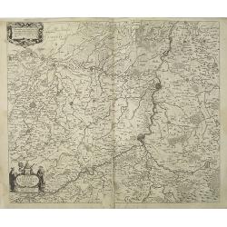
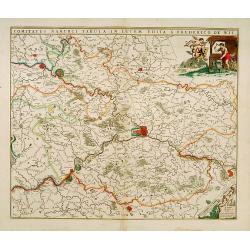
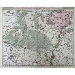
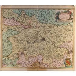
Namurcum comitatus Auctore Johann Surhonio.
Centred on Namen, prepared by Johan Surhonius. With 3 decorative cartouches. More about maps by Willem Blaeu. [+]
Date: Amsterdam, 1645
Selling price: ????
Please login to see price!
Sold in 2020
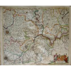
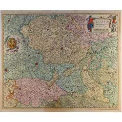
Comitatum Hannoniae et Namurci descriptio.
This is Blaeu’s map of the Belgium region of Hainaut and Namur. Numerous towns and villages are on the map. In the lower right corner is the title cartouche with two co...
Date: Amsterdam, 1645
Selling price: ????
Please login to see price!
Sold in 2017
Flandriae Partes Duae. . .
A very detailed map with Ghent in the centre. Lower right corner is Antwerp, and Vlissingen in top right. At bottom left is a very decorative cartouche with a dedication ...
Date: Amsterdam, 1645
Selling price: ????
Please login to see price!
Sold in 2018
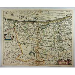
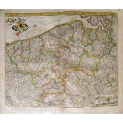
Comitatus Flandriae Nova Tabula.
Fine map of Flanders prepared by Henricus Hondius, the famous mapmaker.A beautiful ornamental title cartouche located on the lower left corner. Dedicated to Dr. Ionni d'H...
Date: Amsterdam, 1645
Selling price: ????
Please login to see price!
Sold in 2018
Mechlinia Dominium, et Aerschot Ducatus.
Blaeu's lovely map of the surrounds of Mechelin in central Belgium. In the upper right corner a beautiful title cartouche is seen, embellished with two female figures, on...
Date: Amsterdam, 1645
Selling price: ????
Please login to see price!
Sold in 2020
Leodiensis dioecesis.
West to the top. Fine map including the Dutch and Belgium provinces Limburg and the Belgium province of Namen and Ardennes. German text on verso.
Date: Amsterdam, 1647
Selling price: ????
Please login to see price!
Sold in 2018
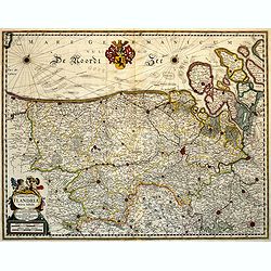
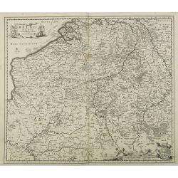
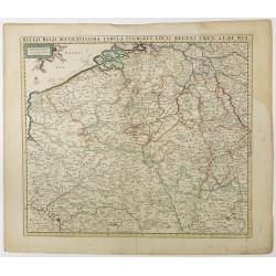
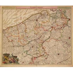
Flandria et Zeelandia Comitatus.
Includes Flanders and Zeeland. The map originally engraved in 1641 for Sanderus 'Flandria Illustrata', was used several times in Blaeu's atlases.
Date: Amsterdam, ca. 1647
Selling price: ????
Please login to see price!
Sold in 2012
Flandria Gallica Continens Castellanias Insulensem Duacensem Orchianensem Civitatem Dominiumq: Tornacense.
This map of a part of Walloon province of Belgium in the centre is Lille, In 1667, Louis XIV of France successfully laid siege to Lille, resulting in it becoming French i...
Date: Amsterdam, 1647
Selling price: ????
Please login to see price!
Sold in 2020
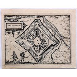
MarieBourg.
This bird's-eye plan of Mariebourg in Belgium illustrates the strategic position of its fortifications . It provides an excellent view of the city's defences, bridges, wa...
Date: Amsterdam, 1649
Selling price: ????
Please login to see price!
Sold in 2019
Iprensis Episcopatus.
Map of the Dioceses of Ypres (1559-1801). Centered on the towns of Ypres and Rouselare.Rare map only included in Joan Blaeu's Atlas Major. Originally engraved for Sanderu...
Date: Amsterdam, 1650
Selling price: ????
Please login to see price!
Sold in 2020
Prima pars Brabantiae cuius caput Lovanium.
Decorative map centred on Tienen and Leuven. West to the top.
Date: Amsterdam 1650
Selling price: ????
Please login to see price!
Sold in 2018
Prima pars Brabantiae cuius caput Lovanium.
Decorative map centered on Tienen and Leuven. West to the top.
Date: Amsterdam, 1650
Selling price: ????
Please login to see price!
Sold in 2018
Prima pars Brabantiae cuius caput Lovanium.
Decorative map centered on Tienen and Leuven. West to the top. Prepared by Michael Floris van Langeren (1612-1675). He was an mathematician and astronomer who served for ...
Date: Amsterdam 1650
Selling price: ????
Please login to see price!
Sold
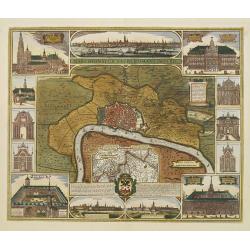
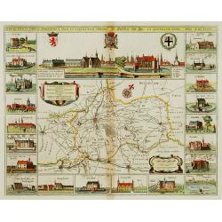
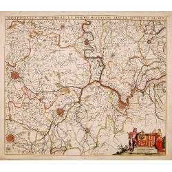
Marchionatus Sacri Romani Imperii.
In the centre a plan of the city of Antwerp with its surroundings. In numerous insets panoramic views of the harbour and parts of the city and pictures of the most import...
Date: Amsterdam, 1650
Selling price: ????
Please login to see price!
Sold
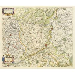
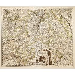
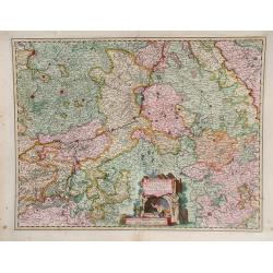
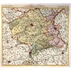
Tertia Pars Brabantiae.
West is at the top. At the lower left the cartouche embellished with male figures with compasses, globe, book and winckel-kruis . At bottom, right of the centre, a beauti...
Date: Amsterdam, 1650
Selling price: ????
Please login to see price!
Sold in 2008
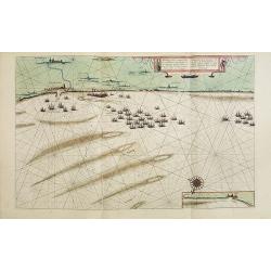
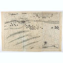
Afbeeldinge vande vermaerde seehaven .. Duynkerken..
Blaeu's chart of the coast of the French coast from Duinkerk till Waldamme. In an inset, lower right the continuation till Calais. Many ships offshore Duinkerk, with soun...
Date: Amsterdam, 1650
Selling price: ????
Please login to see price!
Sold in 2008
Prima pars Brabantiae cuius caput Lovanium.
Decorative map centered on Tienen and Leuven. West to the top.
Date: Amsterdam, 1650
Selling price: ????
Please login to see price!
Sold in 2008
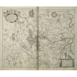
Secunda pars Brabantiae cuis urbus primaria Bruxellae.
At the upper left the title cartouche, decorated with two angels holding the heraldic arms of Brussels, Nijvel and Vilvoorde, next to it that of Brabant. The cartographer...
Date: Amsterdam, 1650
Selling price: ????
Please login to see price!
Sold in 2008
Secunda pars Brabantiae cuis urbus primaria Bruxellae . . .
No text on verso !. At the upper left the title cartouche, decorated with two angels holding the heraldic arms of Brussels, Nijvel and Vilvoorde, next to it that of Braba...
Date: Amsterdam, 1650
Selling price: ????
Please login to see price!
Sold in 2018
Dioecesis Leodiensis
Detailed map of Belgium. Embellished an allegorical title cartouche surrounded by a coat of arms. Shows the Maas, part of Belgium next to Brabant. Cities include Liege, M...
Date: Amsterdam, c. 1650
Selling price: ????
Please login to see price!
Sold in 2023
Afbeeldinge vande vermaerde seehaven ... Duynkerken..
Blaeu's chart of the coast of the French coast from Dunkirk till Waldamme. In an inset, lower right the continuation till Calais. Many ships offshore Dunkirk, with soundi...
Date: Amsterdam, 1650
Selling price: ????
Please login to see price!
Sold in 2020
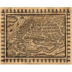
Antorff
Very rare German woodcut birds-eye view of Antwerp during the early 17th century. Shows the city with its buildings and fortifications, and the Scheldt river with ships! ...
Date: Frankfurt, 1658
Selling price: ????
Please login to see price!
Sold in 2010
Comitatus Flandria Noua Tabula.
Finely detailed map of Flanders by Sanson published by Pierre Mariette. Shows the Flemish coastal region from Calais and Dunkirk, France to Antwerp, Belgium and includes...
Date: Paris, 1654-1659
Selling price: ????
Please login to see price!
Sold in 2010
Namurcum Comitatus.
A fine map of the surrounding area around Namur, Belgium, part of the Spanish Netherlands. The map with the Sambre and Meuse rivers and other places like Dunant. It feat...
Date: Frankfurt, 1659
Selling price: ????
Please login to see price!
Sold in 2018
Flandriae Partes duae quarum altera proprietaria . . .
No text on verso.! A very detailed map with Gent in the center. Lower right corner Antwerp and Vlissingen in top right. At bottom left a very decorative cartouche with a ...
Date: Amsterdam, ca. 1660
Selling price: ????
Please login to see price!
Sold in 2009
Dioecesis Leodiensis Accurata Tabula.
Detailed map of Belgium taken from H. Hondius map and updated. Shows the river Maas, part of Belgium next to Brabant. Including the towns of Liege, Maastricht, Namur and ...
Date: Amsterdam, ca.1660
Selling price: ????
Please login to see price!
Sold in 2009
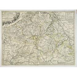
Pars Flandriae Teutonicae.
A fine map of Flemish Flanders with the city of Dunkerque shown and a huge fleet of 39 ships. The interior is well engraved with forests and towns, and extends to the Lys...
Date: Amsterdam, 1660
Selling price: ????
Please login to see price!
Sold in 2018
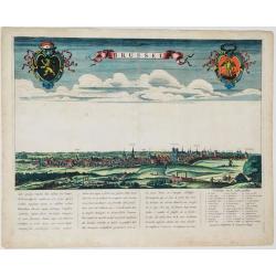
Brussel.
Panoramic view of the city of Brussels seen from the South. Title in a banner at top centre, left and right the coats-of-arms of Brabant and Brussels. Underneath a poetic...
Date: Amsterdam, ca. 1660
Selling price: ????
Please login to see price!
Sold in 2021
Castellaniae Corturiacensis Tabula.
With a dedication by A.Sanderus to the nobles and the magistrates of the Castellany. Very detailed map including the towns of Menen, Tielt, Harelbeke, Cortryck and Deinze...
Date: Amsterdam, 1661
Selling price: ????
Please login to see price!
Sold in 2022
![Nobilibus Amplissimis Q. Dominis D. Georgio De La Faille Toparchae Deneuele &c. Praetori Totiq. Colllegio Supremae Curiae Feudalis Regiae Veteris Burgi Gandensis [Gent]](/uploads/cache/38732-250x250.jpg)
Nobilibus Amplissimis Q. Dominis D. Georgio De La Faille Toparchae Deneuele &c. Praetori Totiq. Colllegio Supremae Curiae Feudalis Regiae Veteris Burgi Gandensis [Gent]
Fine map centered on Gent in Flandres with inset "Graven Kasteel". From Blaeu's Atlas Major.
Date: Amsterdam, 1662
Selling price: ????
Please login to see price!
Sold in 2019
Leodiensis Dioecesis.
A map of Liege, a province in Belgium. A splendidly decorative map of the Muese River and valley, including Namur and Liege, with west oriented at top of map. Franchimo...
Date: Amsterdam, 1662
Selling price: ????
Please login to see price!
Sold in 2018
Flandriae. . .
Charming little map of Belgium made by Gabriel Bucelin (1599-1681). Bucelin was a Swiss genealogist and an author of several books and a number of manuscript maps of Germ...
Date: Ulm, Johannes Görlin, 1658-1664
Selling price: ????
Please login to see price!
Sold in 2008
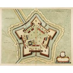
Arx Antverpiensis.
Detailed plan of the Castle and Fort near Antwerp.
Date: Amsterdam, 1666
Selling price: ????
Please login to see price!
Sold in 2022
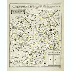
La Flandre Gallicane conquise par le Roy Lan c'est-à-dire La Province ou Chastellenie de Lille. . .
Scarce and detailed map of northern France, centered on Lille with title along the top. The map is dated 1667 and has the address "…proche le Fort l'Euesque, sur l...
Date: Paris, 1667
Selling price: ????
Please login to see price!
Sold
Picardie et les Pays Bas Catoliques &c. . .
Covering southern part of the Netherlands, Belgium and northern part of France. Engraved by R.Cordier Abbauil.Nicolas Sanson was to bring about the rise of French cartogr...
Date: Paris, 1667
Selling price: ????
Please login to see price!
Sold in 2014
Comitatus Flandria Tabula, in Lucem Edita a Frederico de Wit ...
Attractive map of Flanders.
Date: Amsterdam, 1670
Selling price: ????
Please login to see price!
Sold in 2012
Marchionatus sacri imperii et dominii mechelini tabula...
Map of the belgion region of Mechelen.
Date: Amsterdam, 1670
Selling price: ????
Please login to see price!
Sold in 2012
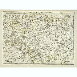
Le duche de Luxembourg et le comte de Namur . . .
The 1675 edition of the copperplate first issued in 1668. Detailed map of the duchy of Luxembourg and including the Belgium region Namur, with the title along the top.Dat...
Date: Paris, 1675
Selling price: ????
Please login to see price!
Sold in 2013
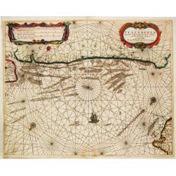
De Cust van Vlaenderen, vande Wielingen to aenden Hoofde.
Theunis Jacobsz, Amsterdam-based maritime publisher added Lootsman (pilot) to his name. After his death in 1650, his sons Jacob Theunisz and Casparus continued the firm. ...
Date: Amsterdam, 1676
Selling price: ????
Please login to see price!
Sold in 2008
Belgii Regii accuratissima Tabula, Auctore Nicolao Visscher.
Map of mainly present-day Belgium. Taken from the atlas Germania Inferior, sive XVII Provinciarum Geographicae generales ut et particulares tabulae. Kaert-Boeck van de XV...
Date: Amsterdam, 16856-1677
Selling price: ????
Please login to see price!
Sold in 2015
![Dormalle in Brab. [Dormael].](/uploads/cache/13748-250x250.jpg)
Dormalle in Brab. [Dormael].
A very nice view of the castle of Dormalle. On the foreground, a snake and a rat are depicted. With a verse in two languages underneath the picture.The poet and topograph...
Date: Frankfurt, 1623-1678
Selling price: ????
Please login to see price!
Sold in 2017
Lovaniensis Tetrarchia una cum Arscotano Ducatu. . .
Decorative map centred on Tienen and Leuven. Also including the towns of Mechelen, Namen, Landen, Leeuw, Aarschot, etc.
Date: Amsterdam, 1680
Selling price: ????
Please login to see price!
Sold in 2018
Leodiensis episcopatus..
Map centred on Liege. Covering the area between Antwerp, Turnhout, Roermond, Cologne, Trier and Dinant.
Date: Amsterdam 1680
Selling price: ????
Please login to see price!
Sold
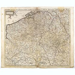
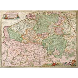
Belgii Regii Accuratissima Tabula Pluribus Locis...
Covering present-day Belgium, Luxembourg, Noord Brabant an Limburg in the Netherlands, and northern part of France.
Date: Amsterdam 1680
Selling price: ????
Please login to see price!
Sold in 2022
Comitatus Namurci Tabula in Lucem..
Centred on Namen, with decorative title cartouche upper right.
Date: Amsterdam 1680
Selling price: ????
Please login to see price!
Sold
Marchionatus sacri imperii.. Mechelini Tabula. . .
Decorative map covering the area of Antwerp, Leuven, Brussels Aalst and Hulst.
Date: Amsterdam, 1680
Selling price: ????
Please login to see price!
Sold in 2018
Comitatus Flandria Tabula, in Lucem Edita a Frederico de Wit Amsterdami.
Frederick de Wit map of Flanders region showing from Arras, France on the south to Antwerp, Belgium in the north with beautiful gold leaf detail.
Date: Amsterdam, 1680
Selling price: ????
Please login to see price!
Sold in 2010
Leodiensis Episcopatus.
Visscher map of Belgium and Trier region of Germany with beautiful original color. Shows Antwerp in the upper left corner, Trier, Germany in lower right corner.
Date: Amsterdam, 1680
Selling price: ????
Please login to see price!
Sold in 2010
Comitatus Hannonia Tabula.
Nicolas Vissher map showing region of northern France and Belgium.
Date: Amsterdam, 1680
Selling price: ????
Please login to see price!
Sold in 2010
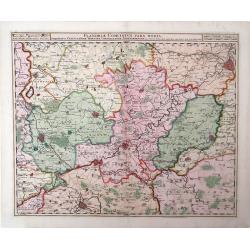
Flandria Comitatus Pars Media.
Nicolas Visscher map, with beautiful original color, showing region of Belgium with city of Gent in the top right corner.
Date: Amsterdam, 1680
Selling price: ????
Please login to see price!
Sold in 2010
Leodiensis Episcopatus Pars Septentrionalis, Comprehendens Comitatum Lossensem et Hornanum
Beautiful map of the Limburg region of Southeastern Netherlands and northern Belgium by Nicolas Visscher. Shows the cities of Maastricht, Hasselt (northern Belgium), Brey...
Date: Amsterdam, c. 1680
Selling price: ????
Please login to see price!
Sold in 2010
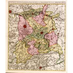
Comitatus Flandriae Accuratissima, descriptio,. . .
Uncommon and detailed map of the provinces of Flanders and Brabant in present-day Belgium.Magnificent title- and scale cartouches etched by Romeijn de Hooghe.
Date: Amsterdam, 1680
Selling price: ????
Please login to see price!
Sold in 2014
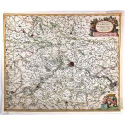
Comitatus Namurci..
Detailed map of a part of Belgium with Namur in the middle. Large (colored) cartouche with putti and one with a coat of arms.
Date: Amsterdam ca.1680
Selling price: ????
Please login to see price!
Sold in 2014
Comitatus Hannoniae..
Detailed map of a part of Belgium with Bergen/Mons in the middle. Large (colored) cartouche with putti and one with a coat of arms.
Date: Amsterdam ca.1680
Selling price: ????
Please login to see price!
Sold in 2014
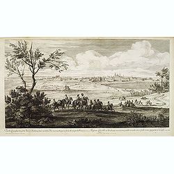
Veue de Leuve, place très-forte dans le Brabant, située au milieu d'un marais, attaquée et forcée de nuit par les François en l'année 1678. . . (Zoutleeuw)
Showing the siege of the town of Zoutleeuw. Showing the French cavalry advancing in the direction of the Sint-Truiden port. Giving a clear picture of the old Holy Cross C...
Date: Paris, ca. 1680
Selling price: ????
Please login to see price!
Sold
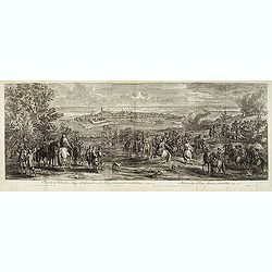
Veuë de la Ville et du Siège d'Oudenarde, ou le Roy commande en personne, en l'année 1667.
Showing the town of Oudenaarde. Etching after Adam Frans van der Meulen (1632-1690) who was a Flemish Baroque painter specializing in battle scenes. He was active first i...
Date: Paris, ca. 1680
Selling price: ????
Please login to see price!
Sold in 2017
Comitatus Flandriae Tabula in lucem edita.
Map of Flanders, the whole Belgian region northwest of Brussels, confined by Antwerp, Brussels, Valenciennes, Arras, St. Omer and the Channel.Title heading above the map,...
Date: Amsterdam, 1680
Selling price: ????
Please login to see price!
Sold in 2018
Belgii Regii Accuratissima Tabula Pluribus Locis recens emen: A F. DE Wit.
Covering present-day Belgium, Luxembourg, Noord Brabant an Limburg in the Netherlands, and northern part of France.
Date: Amsterdam, 1680
Selling price: ????
Please login to see price!
Sold in 2016
Comitatus Flandriae Tabula, In Lucem Edita A Frederico De Wit.
Double page map of Flanders, the whole Belgian region northwest of Brussels, confined by Antwerp, Brussels, Valenciennes, Arras, St. Omer and the Channel. Title heading a...
Date: Amsterdam, 1680
Selling price: ????
Please login to see price!
Sold in 2016
Comitatus Hannonia et Episcopatus Cambresis Descriptio Auctore
A pleasing map of the Belgian region of Hannonia. Adorned with a cartouche including a coat of arms with soldiers on horses surrounding. Also has an interesting vertical ...
Date: Amsterdam, 1680
Selling price: ????
Please login to see price!
Sold in 2016
Belgii Regii Accuratissima Tabula Pluribus Locis. . .
Covering present-day Belgium, Luxembourg, Noord Brabant an Limburg in the Netherlands, and northern part of France.
Date: Amsterdam, 1680
Selling price: ????
Please login to see price!
Sold in 2023

Flandriae Partes duae, quarum altera proprietaria, altera imperialis. . .
No text on verso.! A very detailed map with Gent in the center. Lower right corner Antwerp and Vlissingen in top right. At bottom left a very decorative cartouche with a ...
Date: Oxford, 1682
Selling price: ????
Please login to see price!
Sold in 2011
Flandriae Comitatus Pars Australis.
A finely engraved decorative map of southern Flanders, centered on Ryssel / Lille. The cities and topography are shown in detail with a miniature plan representing the f...
Date: Amsterdam, 1683
Selling price: ????
Please login to see price!
Sold in 2016
Mechlinia Dominium et Aerschot Ducatus Auctore Nicolao Visscher.
Fine decorative map of part of Belgium including the cities of Antwerp, Mechelen, Brussels, Leuven and Tienen. Taken from the atlas Germania Inferior, sive XVII Provincia...
Date: Amsterdam, 1684
Selling price: ????
Please login to see price!
Sold in 2015
Belgii Regii Tabula, in qua omnes Provincia ab Hispanis ad Annum 1684 possessae, nec nontam a Rege Galliea quam Batavis acquifitae. . .
Beautifully colored map of present day Belgium, northern France, Luxembourg and the Netherlands from Visscher's Germania Inferior. Paris and Luxembourg are shown in the s...
Date: Amsterdam, 1677-1684
Selling price: ????
Please login to see price!
Sold in 2010
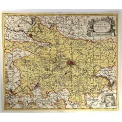
Comitatus Namurci Emendata Delineatio, Nuperrimè in lucem edita, per Nicolaum Visscher.
A detailed engraved map of the Belgian province of Namur (Namen), showing some cities including; Namur, Dinant & Charleroi. From the atlas “Germania Inferior, sive ...
Date: Amsterdam, 1684
Selling price: ????
Please login to see price!
Sold in 2016
Comitatus Namurci Emendata Delineatio.
A fine copperplate map of the Namur region of Belgium, with the city of Namur at the center. Two large cartouches feature three putti making weapons, wearing armour and s...
Date: Amsterdam, 1684
Selling price: ????
Please login to see price!
Sold in 2016
Comitatus Namurci Emendata Delineatio Nuperrine in Lucem.
Map by Nicholas Visscher of the area around the Belgium city of Namur from Philipville to Huy and Charlemont. This map includes major cities such as Buillon, Fontaine and...
Date: Amsterdam, 1685
Selling price: ????
Please login to see price!
Sold in 2010
Prouincie Meridionalide Paesi Bassi..
Rossi's map of Belgium and northern France and Luxembourg, based upon Sanson's map, but with revised Italian nomenclature. The engraver was Giorgio Widman.Issued in Il Me...
Date: Rome, 1677-1688
Selling price: ????
Please login to see price!
Sold in 2016
Flandriae Comitatus.
Frederik de Wit (1610-98), Amsterdam-based cartographer and publisher. ' Atlas minor', 1670, ' Zee-Atlas', 1675, ' Atlas Major', 1690.Nicolaas Visscher's attractive map o...
Date: Amsterdam, c.1690
Selling price: ????
Please login to see price!
Sold in 2013
La partie Meridionale des Pays-Bas, Connue sous le nom de FLANDRE divisée en plusieurs Provinces. . .
Although the title cartouche states Flanders, or the Spanish part of the 17 provinces of the Low Countries, the map shows present-day Belgium. Title cartouche on the uppe...
Date: Paris, 1690
Selling price: ????
Please login to see price!
Sold in 2022
Comitatus Namurci Tabula.
Carol Allard map of Belgium, shows the city of Namur in the center.
Date: Amsterdam, 1690
Selling price: ????
Please login to see price!
Sold in 2010

