Browse Listings in Europe
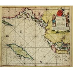
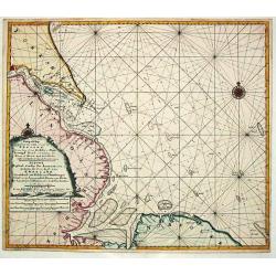
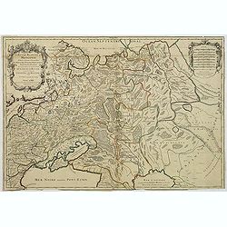
Paskaart Voor een gedeelte van de Oost-Zee. Beginnende van Schenkkenes tot aan Stokholm.
The successful van Keulen firm published charts, pilot guides and sea-atlases for over 2 centuries. Founded by Johannes van Keulen, his son Gerard led the firm to its zen...
Date: Amsterdam, 1715
Selling price: ????
Please login to see price!
Sold
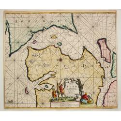
Pascaart Om door de Sond En de Droogen te Seylen Stekkende van Kol tot Meun.
The successful van Keulen firm published charts, pilot guides and sea-atlases for over 2 centuries. Founded by Johannes van Keulen, his son Gerard led the firm to its zen...
Date: Amsterdam, 1715
Selling price: ????
Please login to see price!
Sold
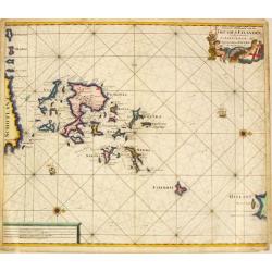
Nieuwe Paskaart van de Orcades Eylanden
The successful van Keulen firm published charts, pilot guides and sea-atlases for over 2 centuries. Founded by Johannes van Keulen, his son Gerard led the firm to its zen...
Date: Amsterdam, 1715
Selling price: ????
Please login to see price!
Sold in 2010
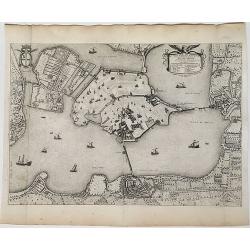
![[Varsovie]](/uploads/cache/24496-250x250.jpg)
[Varsovie]
Bird's eye-view of Warsaw. With a smaller frontal view of the town in the lower part and 2 insets in the upper corners illustrating Louwitz or Lowicz Castle. Engraved by ...
Date: Paris, ca. 1715
Selling price: ????
Please login to see price!
Sold in 2008
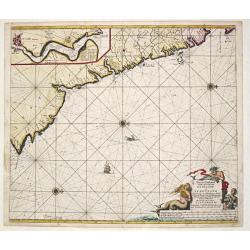
Nieuwe Paskaert Vande oost Cust van Engeland en Schotland. Beginnende van 't Flamburger Hooft tot aan de Rivier van Eedenborg. Inset: The River Tyne.
The successful van Keulen firm published charts, pilot guides and sea-atlases for over 2 centuries. Founded by Johannes van Keulen, his son Gerard led the firm to its zen...
Date: Amsterdam, 1715
Selling price: ????
Please login to see price!
Sold in 2008
Nieuwe Wassende Gradige Pas-kaart van een gedeelte der oost-kust van Engeland, Strekkende van Eckles tot Flambrouger Hooft , in zig begrypende de Rievier van Hull.
The successful van Keulen firm published charts, pilot guides and sea-atlases for over 2 centuries. Founded by Johannes van Keulen, his son Gerard led the firm to its zen...
Date: Amsterdam, 1715
Selling price: ????
Please login to see price!
Sold in 2011
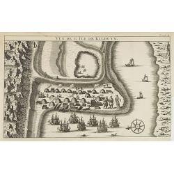
Vüe de l'Ile de Kilduyn.
A view of the Kilduyn Island on the Kola River in Russia. In upper right corner "To. 3. pa.24."The Kola River in the northern part of the Kola Peninsula...
Date: 1715
Selling price: ????
Please login to see price!
Sold in 2009
Russiae et Novae Zemblae Maritimae.
Splendid sea-chart of the Barents Sea coast from Murmansk to Novaya Zemlya. The chart is embellished with sailing ships, whaling scenes. In the upper right corner a title...
Date: Amsterdam, 1715
Selling price: ????
Please login to see price!
Sold in 2009
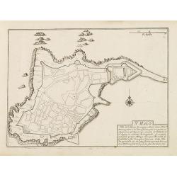
St. Malo
Fortification town-plan of St. Malo in Brittany. Wind rose and explanatory panel in lower right corner.Nicolas de Fer [1646-1720] was one of the most prolific and influen...
Date: Paris, 1715
Selling price: ????
Please login to see price!
Sold
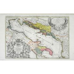
Le Golfe de Venise Avec ses Principaux Caps Promontiores & Ports de Mer. . .
Map of the Gulf of Venice also known as the Adriatic Sea by Sanson and published by Covens and Mortier. The colored areas include southern Italy to the west and Dalmatie ...
Date: Amsterdam, c. 1715
Selling price: ????
Please login to see price!
Sold in 2010
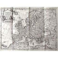
L'EUROPE suivant les Nouvelles Observations...
Charming map of Europe, including parts of North Africa, the Near East, and Russia. Very detailed map with many place names (cities, rivers, lakes, islands, etc). Decorat...
Date: Leiden, c.1715
Selling price: ????
Please login to see price!
Sold in 2011
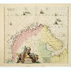
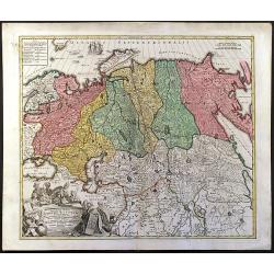
Finmarchae et Laplandiae Maritima. / Nieuwe Pascaert vande Kusten Finmarcken en Lapland Streckende van Dronten tot Archangel.
An eye-catching chart of Barents Sea and White Sea (with Archangelsk) with the coast of Norway, Lapland and peninsula Kola.. Coastal cities, bodies of water and islands a...
Date: Amsterdam, 1715
Selling price: ????
Please login to see price!
Sold in 2012
Oxford Shire Actually Survey'd &c. . .
Scarce extensive county map, north oriented to the right. With an elaborate title cartouche, 5 inset views of "The Prospect of Oxford," "The Theatre,"...
Date: London, 1715
Selling price: ????
Please login to see price!
Sold in 2015
![[Varsovie].](/uploads/cache/37246-250x250.jpg)
[Varsovie].
Bird's eye-view of Warsaw. With a smaller frontal view of the town in the lower part and 2 insets in the upper corners illustrating Louwitz or Lowicz Castle. Engraved by ...
Date: Paris, ca. 1715
Selling price: ????
Please login to see price!
Sold in 2016
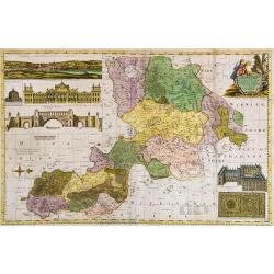
Regiae Celsitudinis Sabaudicae. . .
A detailed map of the Piedmont region in Northern Italy. The major cities of Torino, Milan, and Genoa and Geneva, Switzerland are all shown. Johann Baptist Homann was a G...
Date: Nuremberg, ca. 1715
Selling price: ????
Please login to see price!
Sold in 2017
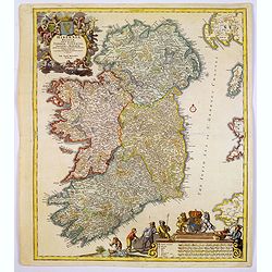
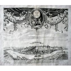
Hiberniae regnum. . .
A detailed and decorative map of Ireland, colored by the 4 regions and showing the towns, roads, counties, rivers, lakes, castles, etc. Includes a pair of lovely cartouch...
Date: Nurnberg, 1715
Selling price: ????
Please login to see price!
Sold in 2017
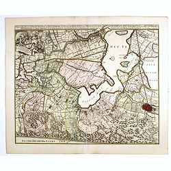
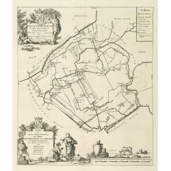
Nieuwe Kaerte van t'Baljuwschap van Kennemerland met de Bannen van Westsaanen, Assendelft, Heemskerk . . .
Rare map prepared by Elisabeth Visscher who was the widow of Nicolas Visscher and republished by Petrus Schenk. East to the top. Including Haarlem, Heemskerk, Velsen, etc...
Date: Amsterdam, 1715
Selling price: ????
Please login to see price!
Sold in 2017
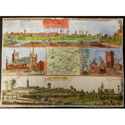
The prospects of the two most remarkable towns in the north of England for the clothing trade, viz. Leeds, As it appears from Holbeck Road, and Wakefield, As it appears from London Road.
This plate was published in Ducatus Leodiensis, or the Topography of the Town and Parish of Leedesby the Yorkshire antiquary Ralph Thoresby.Thoresby continued his father�...
Date: London, 1715
Selling price: ????
Please login to see price!
Sold in 2017
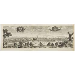
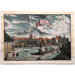
Stockholmia metropolis regni Sueciae et sedes regia qua parte . . .
Very decorative etching of Stockholm by the Parian master engraver and etcher Perelle (1638 - 1695). The title between two elegant cartouches decorated with cherubs, the ...
Date: Paris, 1715
Selling price: ????
Please login to see price!
Sold in 2018
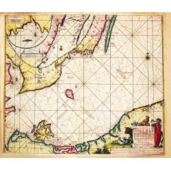
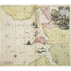
Paskaart Voor een gedeelte van de Oost-Zee. Beginnende van Valsterborn tot Schenkkenes.
A sea chart of the southwest part of the Baltic with two insets showing the coast between Kristianstad and Calmer, and the ports of 'Selfborgh, Boetekolen Rottenbuy'....
Date: Amsterdam, 1715
Selling price: ????
Please login to see price!
Sold in 2021
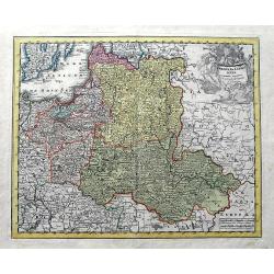
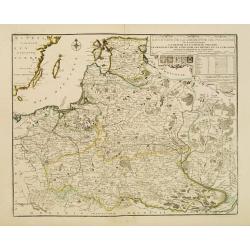
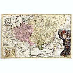
Poloniae & Lithuania accurante curatius.
A very scarce map of Poland, Lithuania, and a large part of Latvia. The copper engraved map extends from the Baltic Sea until Hungary and the southern Ukraine. Published ...
Date: Nuremberg, ca 1715
Selling price: ????
Please login to see price!
Sold in 2019
![[Varsovie].](/uploads/cache/45606-250x250.jpg)
[Varsovie].
Bird's eye-view of Warsaw. With a smaller frontal view of the town in the lower part and 2 insets in the upper corners illustrating Louwitz or Lowicz Castle. Engraved by ...
Date: Paris, ca. 1715
Selling price: ????
Please login to see price!
Sold in 2020
Ville et Environs de Mantoue.
An extremely detailed city map of Mantova in Lombardia, published by Pierre Mortier, after Blaeu. An attractive birds-eye view including all the city's main buildings, in...
Date: Amsterdam, 1704/1715
Selling price: ????
Please login to see price!
Sold in 2022
Les Etats de la couronne de Pologne..
Rare map of Poland. In upper right corner a title cartouche, key with longitudes and latitudes to the important cities and coats of arms of Poland, Lithuania, Prussia, Cu...
Date: Paris 1716
Selling price: ????
Please login to see price!
Sold
Generalis Totius Imperii Russorum Novissim Tabula
Map of the Russian Empire. With beautiful cartouche, ships and seamonsters.
Date: Nuremberg, 1716
Selling price: ????
Please login to see price!
Sold in 2008
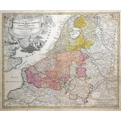
Tabula Generalis Totius Belgii qua Provincia XVII Infer Germania olim fub S.R.I. Circulo Burgundia . . .
Decorative map by Johann Baptist Homann which shows the entire region of The Netherlands and Belgium with its seventeen provinces. A decorative title cartouche is in the ...
Date: Nuremberg, 1716
Selling price: ????
Please login to see price!
Sold in 2010
Carte d'Artois et des Environs ou lon voit le Ressort du Conseil Provincial d'Artois.
Finely detailed map of the Artois region of northern France bordering Belgium, showing the cities of Douai, Arras and Lille. Once a state of the Holy Roman Empire, Artois...
Date: Paris, 1716
Selling price: ????
Please login to see price!
Sold in 2010
Carte de la Geographie sacrée pour l'ancien testament. . .
Beautiful map of the coast of the Mediterranean, including the south of France, Italy, the north African coast, and the near east. On the left, there is a "Table mé...
Date: Paris, 1716
Selling price: ????
Please login to see price!
Sold in 2012
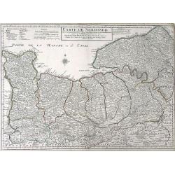
Carte de Normandie ousont marquez exacteme Les Pays ou Contrees enferm ees dascette Province aussi bien que les Villes Bourgs Paroissese.
Finely detailed map of the Normandy region of France by Guillaume de L'Isle. Shows the coastline along the English channel, along with the towns and villages, forests, ab...
Date: Paris, 1716
Selling price: ????
Please login to see price!
Sold in 2010
To His Most Serene and August Majesty Peter Alexovitz Absolute Lord of Russia &c. This map of Moscovy, Poland, Little Tartary, and ye Black Sea &c. is most Humbly Dedicated by H. Moll Geographer
Magnificent large-scale, English map of Russia, Ukraine, Poland, Finland and the Baltic Countries and extending south to the Black Sea and the Balkans, with an ornate ded...
Date: London, 1716
Selling price: ????
Please login to see price!
Sold in 2015
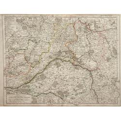
Theatrum Belli Rhenani Auspicatis Militiæ Primitis Potentissimi Roman et Hunga Regis. . .
A detailed and very decorative regional map of the Rhine and Moselle Regions in Germany, exhibiting the Theatre of War in 1702.The inset in the lower left corner traces t...
Date: Nuremberg, 1716
Selling price: ????
Please login to see price!
Sold in 2018
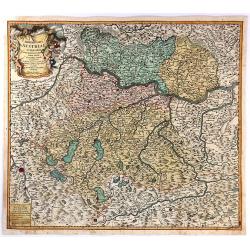
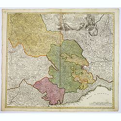
Archiducatus Austriae Superioris.
An antique map of Ober-Österreich between Inn, Donau and Enns, reaching from Passau along the Danube to Ybbs, and south to Salzburg and Rottenmann. After Nicolaas Vissch...
Date: Nuremberg, 1716
Selling price: ????
Please login to see price!
Sold in 2018
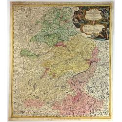
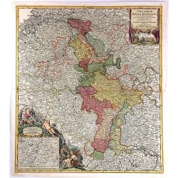
Bavariae Circulus et Electorat in Suasquasque Ditiones...
A striking copper engraved map detailing Bavaria bounded by Nuremberg, Munich, and Passau.The map locates many fortified cities including Munich, Salzberg, Nuremberg, Pas...
Date: Nuremberg, 1716
Selling price: ????
Please login to see price!
Sold in 2016

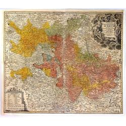
S.R.I. Circulus Rhenanus Inferior sive Electorum Rheni.
A detailed copper engraved map of central Germany that follows the Rhine River from the French border to beyond Dusseldorf. The Moselle River follows the landscape throug...
Date: Nuremberg, 1716
Selling price: ????
Please login to see price!
Sold in 2016
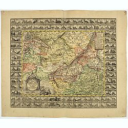
Exactissima Palatinatus Ad Rhenum Tabula, In Qua Episcopus Wormaciensis et Spirensis Ducatus
A fine copperplate map of the Rheinland/Palatinate region of Germany. It displays the area between Cochem on the Mosel, Frankfurt, Marbach, and Saarlouis, the Electorate...
Date: Nuremberg, 1716
Selling price: ????
Please login to see price!
Sold in 2016
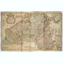
Les Provinces des pays-Bas Catholiques. . .
This is an interesting map that can be dated to after the treaty of Utrecht (1712) as this was when Austria was given the Netherlands, and they are designated the 'Austri...
Date: London, ca 1716
Selling price: ????
Please login to see price!
Sold in 2017
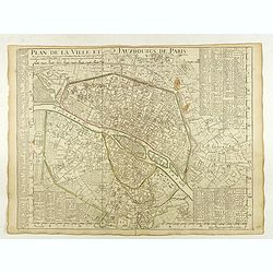
Plan de la Ville et Fauxbourgs de Paris.
A detailed plan of the city and surrounding suburbs of Paris, published "A Paris chez l’Auteur sur le Quai de l’Or.loge avec Pr.r Juin 1716" .The plan has i...
Date: Paris, 1716
Selling price: ????
Please login to see price!
Sold in 2022
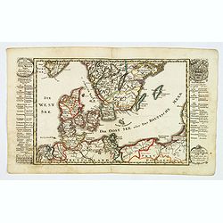
Der Nordischen Konigreiche Sud-West Theil.
An attractive map of the southwest portion of the Nordic kingdom, showing southern Sweden and Denmark, a tiny tip of southern Norway, plus some of the northern German and...
Date: Augsberg, 1716
Selling price: ????
Please login to see price!
Sold in 2021
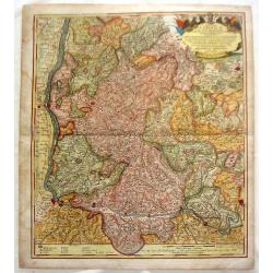
Das Stifft Naumburg und Zeitz nebst einem grossen Theil der angraenzenden Laender. Verfertiget und in Kupffer gestochen von Johann George Schreibern.
Exceptionally rare, early cartographic work of the Leipzig engraver and Atlas publisher Johann Georg Schreiber (1676-1750), who created only two large-portfolio cards in ...
Date: Leipzig, ca. 1716
Selling price: ????
Please login to see price!
Sold in 2020
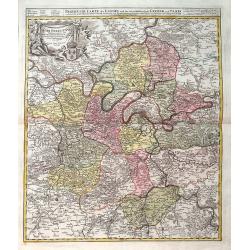
Agri Parisiensis. . .
A detailed map of Île-de-France centered on Paris. Paris is still quite small - Montmartre, Les Invalides, and others are shown as small separate villages. Extends until...
Date: Nuremberg, ca 1716
Selling price: ????
Please login to see price!
Sold in 2019
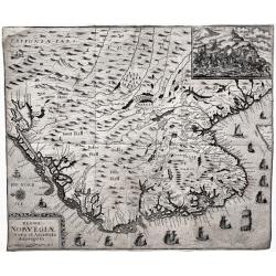
Regni Norvegiæ Nova et Accurata descriptio.
A very rare, decorative map of Norway with inset battle scene and many ships sailing along the coast. The map was included in the fall 1716 issue of Relationis Historicæ...
Date: Frankfurt, 1716
Selling price: ????
Please login to see price!
Sold in 2020
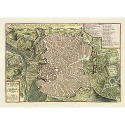
Madrid, ville Considerable de la Nouvelle Castille. . .
Plan of Madrid engraved by C Inselin, stretching from Westminster Abbey in the west to Mile End in the east. A 26 point key identifies important landmarks.From De Fer's &...
Date: Paris, 1717
Selling price: ????
Please login to see price!
Sold in 2011
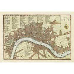
Plan des villes de Londres et de Westminster et de leurs Faubourgs avec le bourg de Southwark. . .
Plan of London engraved by C Inselin, stretching from Westminster Abbey in the west to Mile End in the east. A 113 point key identifies important landmarks.This is the ra...
Date: Paris, 1717
Selling price: ????
Please login to see price!
Sold in 2011
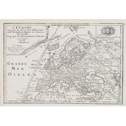
L'Europe, Suivant les Nouvelles Observations de M.rs de L'Academie Royale des Siences. . .
The map was published by N. de Fer (1646-1720), Geographe du Roy, and shows in great evidence the Meridian Line choose by French cartographers in 1634 as framework for th...
Date: Paris, 1717
Selling price: ????
Please login to see price!
Sold in 2018
La Russie Blanche ou Moscovie divisée. . .
Fine map of the European part of Russia with a decorative title and scale cartouche.Alexis-Hubert Jaillot (1632-1712), was a French cartographer. He joined the Sanson hei...
Date: Paris, 1717
Selling price: ????
Please login to see price!
Sold in 2011
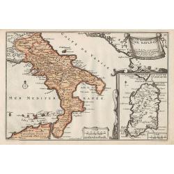
Le Royaume de Naples.
Map of the southern part of Italy, with an inset picturing Sardinia.From De Fer's Atlas Curieux.
Date: Paris, 1705-1717
Selling price: ????
Please login to see price!
Sold in 2012
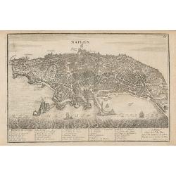
Naples.
Map of the city of Naples.From De Fer's Atlas Curieux.
Date: Paris, 1705-1717
Selling price: ????
Please login to see price!
Sold in 2012
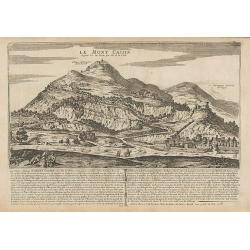
Le Mont Cassin ...
Engraving of Monte Cassino, near the town of Cassino between Rome and Naples.From De Fer's Atlas Curieux.
Date: Paris, 1705-1717
Selling price: ????
Please login to see price!
Sold in 2014
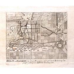
Hulst in Flandern von Denen Franzosen, 1702.
Fine copper engraving of the Hulst Fortress by Merian from "THEATRUM EUROPAEUM" in 1717.
Date: Frankfurt am Main, 1717
Selling price: ????
Please login to see price!
Sold in 2015
La Russie Blanche ou Moscovie Divisee Suivant l'Estendue Des Royaumes Duches. . .
European Russia, including Ukraine. With ornamental title cartouche and scale cartouche in the upper corners. Russia, extending from the Baltic and Black Seas to Grande T...
Date: Paris, ca. 1685 - 1717
Selling price: ????
Please login to see price!
Sold in 2016
Nova et accurata Tabula sedis belli in Regno Hungariae. Accendunt cetera Regna Sclavonia, Croatia, Bosnia, Servia, Dalmatia, Bulgaria et Romania . . .
Wall map in 4 separate sheets, if joined 915 x 1118mm. Map of Hungary, with Transylvania, Croatia, Poland and Slovenia after Conte Luigi Marsigli (1658-1730, an Italian m...
Date: Amsterdam, 1717
Selling price: ????
Please login to see price!
Sold in 2016
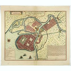
Plan De La Nouvelle Ville De Petersbourg.
The first printed city plan of St. Petersburg, created not long after the founding of the City by Czar Peter the Great. Shows St. Petersburg as it was planned to be built...
Date: Paris, 1717
Selling price: ????
Please login to see price!
Sold in 2019
Prospect Dom Obern Thor Zu Altdorff.
Fine city view of Altdorff Bei Nurnberg, Germany by Johann Puschner in 1717. The view features the protected entrance to the city with a carriage and horses entering. It ...
Date: Nurnberg, 1717
Selling price: ????
Please login to see price!
Sold in 2017
Bellogradum VI Capitur.
An extremely rare, large view of Belgrade. Just one copy found (in the Bayerische Staatsbibliotek, Munich, Germany). It seems to be made of two copper plates, the lower o...
Date: Augsburg / Amsterdam, 1717
Selling price: ????
Please login to see price!
Sold in 2017
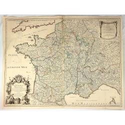
Le Royaume de France Dresse les Memoires et Nouvelles Observations de Messieurs de l'Academie Royalle de Sciences
Very large, copper engraved map of France. It was published by the Jaillot family in Paris in 1717. The map features a large title cartouche with a coat of arms surround...
Date: Paris , 1717
Selling price: ????
Please login to see price!
Sold in 2018
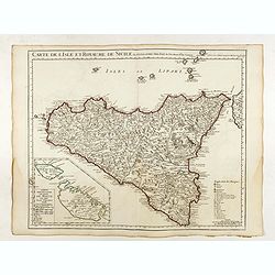
Carte de l'Isle et Royaume de Sicile . . .
Detailed map of Sicily. Inset map of Malta :"Carte particulière de l'Ile de Malte". With the address : Chez l’Auteur sur le Quai de l’Horloge avec Privileg...
Date: Paris, 1717
Selling price: ????
Please login to see price!
Sold in 2022
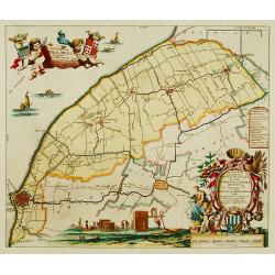
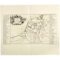
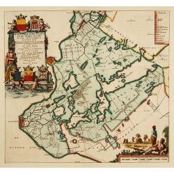
Frisiae dominium vernaculé Friesland..
Very detailed and decorative map of Friesland. Upper left hand corner inset map of the Frisian islands. Lower left statue of the Steenen Man of Harlingen. Key map from th...
Date: Amsterdam 1718
Selling price: ????
Please login to see price!
Sold
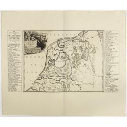
Descriptio Agri Frisii..
Historical map of the northern part of the Netherlands, north of the river Rhine and east of the river Elbe. Prepared by the Menso Alting (1637-1713). He was burgomaster ...
Date: Amsterdam 1718
Selling price: ????
Please login to see price!
Sold
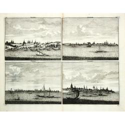
Niesna / Swyatski / Casan / Samara
Four views on one sheet of Russian towns.
Date: Amsterdam, 1718
Selling price: ????
Please login to see price!
Sold
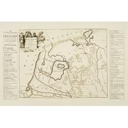
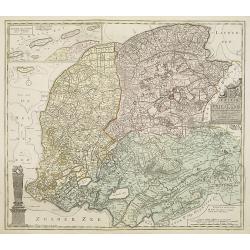
Descriptio Frisiae. . .
Historical map of the present-day Low Countries prepared by the Menso Alting (1637-1713). He was burgomaster of Groningen and geographer, who prepared in 1701 his histori...
Date: Leeuwarden, F.Halma, 1718
Selling price: ????
Please login to see price!
Sold in 2018
Descriptio veteris Agri Batavi et Frisii. . .
Historical map of the present-day Low Countries prepared by the Menso Alting (1637-1713). He was burgomaster of Groningen and geographer, who prepared in 1701 his histori...
Date: Leeuwarden, F.Halma, 1718
Selling price: ????
Please login to see price!
Sold in 2018
Frisiae dominium vernaculé Friesland. . .
Very detailed and decorative map of Friesland. Upper left hand corner inset map of the Frisian islands. Lower left statue of the Steenen Man of Harlingen. Key map from th...
Date: Amsterdam, 1718
Selling price: ????
Please login to see price!
Sold in 2013
Stellingwerf westeinde, de tiende en laafte Grientenije van de Zevenwolden. . .
Very decorative map, with decorative title cartouche lower right, and with three finely engraved cherubs in the upper left corner holding a coat of arms. From the Uitbeel...
Date: Amsterdam, 1718
Selling price: ????
Please login to see price!
Sold in 2010
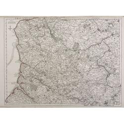
Carte de la Beauce du Gatinois de la Sologne et Pays voifins compris dans la Generalite d\'Orleans.
Detailed map of region of central France south of Paris. The Loire River is depicted with the city of Orleans in the center of the map. The Loire was once an important na...
Date: Paris, 1718
Selling price: ????
Please login to see price!
Sold in 2010
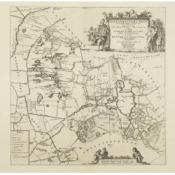
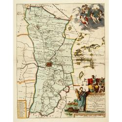
Gaasterland. De zevende Grietenije van de Zevenwolden. . .
Very detailed map of "Gaasterland. De zevende Grietenije van de Zevenwolden" in Friesland prepared by Bernardus Schotanus Steringa. With Sloter Meer and the tow...
Date: Leeuwarden, 1718
Selling price: ????
Please login to see price!
Sold in 2014
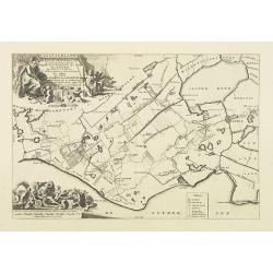
Tjietjerkstera deel. De achtste Grietenije van Ooster-Goo. . .
Very detailed map of "Tjietjerkstera deel. De achtste Grietenije van Ooster-Goo" in Friesland prepared by Bernardus Schotanus Steringa. Centered on Bergum and B...
Date: Leeuwarden, 1718
Selling price: ????
Please login to see price!
Sold in 2014
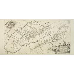
De Grietenije van Smallingerland de negende grietenij van Oostergo
Very detailed map of "De Grietenije van Smallingerland de negende grietenij van Oostergo" in Friesland prepared by Bernardus Schotanus van Steringa. With decora...
Date: Leeuwarden, 1718
Selling price: ????
Please login to see price!
Sold in 2018
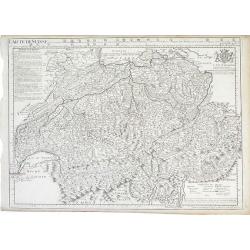
Carte De Suisse.
Detailed map of Switzerland showing different cantons (administrative units) within the country extending to the borders of France, Italy and Germany. The map includes a ...
Date: Paris, 1718
Selling price: ????
Please login to see price!
Sold in 2010
Rauwerderhem de elfde grietenije van Oostergoo . . .
A very detailed map of "Rauwerderhem de elfde grietenije van Oostergoo" in Friesland prepared by Bernardus Schotanus Steringa. Centered on Deersum with in lower...
Date: Leeuwarden, 1718
Selling price: ????
Please login to see price!
Sold in 2010
Leeuwerdera deel.. der stad Leeuwerden. . .
Very decorative map centered on Leeuwarden from the Uitbeelding der Heerlijkheit Friesland prepared by Schotanus. With decorative title cartouche lower right mentioning t...
Date: Amsterdam, 1718
Selling price: ????
Please login to see price!
Sold in 2012
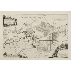
Hemelumer oude vaart en de Noort Woude. . .
Very decorative map including the towns of Staveren, Hindelopen, Workum and several of the Frisian Lakes from the Uitbeelding der Heerlijkheit Friesland prepared by Schot...
Date: Leeuwarden, F.Halma, 1718
Selling price: ????
Please login to see price!
Sold in 2014
Imp. Caes. Carolo VIAugusto Pio Victori.
Highly decorative copperplate map showing Breisgau & Schwarzwald provinces featuring "The Black Forest" & the River Rhine. Interesting allegorical title...
Date: Nuremberg, 1718
Selling price: ????
Please login to see price!
Sold in 2014
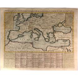
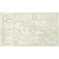
Nouvelle Carte des Conciles Generaux et Particuliers qui se sont Tenus en Europe...
A fine map of the lands bordering the Mediterranean Sea, including Most of Europe, North Africa & Western Asia.The map was drawn to show the cities where Ecclesial Co...
Date: Paris, 1718
Selling price: ????
Please login to see price!
Sold in 2016
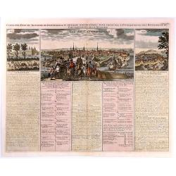
Carte de l'Etat du Royaume de Dannemarck...
Views of the Kingdom of Denmark and various observations about the history and government of this Kingdom.The map shows three views: Friderichsbourg, Copenhagen and Berge...
Date: Amsterdam, 1718
Selling price: ????
Please login to see price!
Sold in 2017
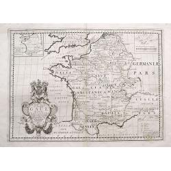
A New Map of Ancient Gaul or Gallia Transalpina...
Decorative map of France, as divided by Augustus Ceasar during Roman times. With the large title cartouche bearing the Royal Coat of Arms.
Date: London, 1718
Selling price: ????
Please login to see price!
Sold in 2016
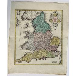
Anglia Cambdeni, excusa a Christopho Weigelio Norimbergae.
A copper engraved map, overall size 50 x 40 cm.This map shows England and Wales, with parts of Scotland. From Weigels' 'Schul und Reise atlas'. Elaborate cartouche with 5...
Date: Nurnberg, ca. 1718
Selling price: ????
Please login to see price!
Sold in 2017
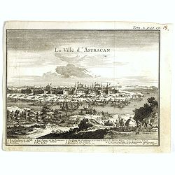
La ville d'Astracan.
Panoramic view of the town of Astracan, based on the observations of Jan Janszoon Struys. In lower part a numbered key (1-14) to the most important buildings.From "I...
Date: Amsterdam, ca. 1718
Selling price: ????
Please login to see price!
Sold in 2017
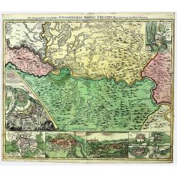
SERBIA - BANAT. UNGARISCHES KRIEGS THEATRUM.
A large and detailed, very decorative map of the theatre of war between the Austrians and Ottoman Turks 1716-17, fought in Romania and Serbia. Under Prince Eugene of Savo...
Date: Nuremberg, 1718
Selling price: ????
Please login to see price!
Sold in 2022
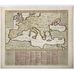
Nouvella Carte des Conciles Generaux et Particuliers qui se sont tenus en Europe, en Asie, En Afrique etc. . .
A fine map of the lands bordering the Mediterranean Sea, including Most of Europe, North Africa & Western Asia. The map was drawn to show the cities where Ecclesial C...
Date: Paris, 1718
Selling price: ????
Please login to see price!
Sold in 2020
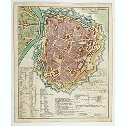
Urbis Augustae Vindobonae.
Engraved city map of Augsburg by Christoph Weigel. Plan of the city with fortifications, left Leopoldstadt, below an extensive key with description. From Bequemer Schul- ...
Date: Nuremberg, 1718
Selling price: ????
Please login to see price!
Sold in 2023