Browse Listings in Europe
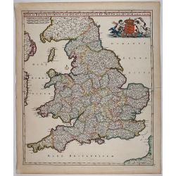
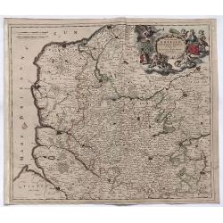
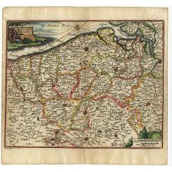
Anglia Regnum In Omnes Suos Ducatus, Comitatus, et Provincias Divisum.
Decorative map of England and Wales showing immense detail of the cities and towns, colored by counties. Very decorative cartouche with mermaids holding up the arms of En...
Date: 1690
Selling price: ????
Please login to see price!
Sold in 2018
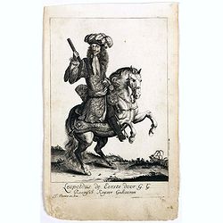
Leopoldus de Eerste door G. G. Roomsch Keijser Gekooren.
Equestrian portrait of the Holy Roman Emperor Leopold I, full-length in profile to left but looking at the viewer, horse seen in frontal view, after Pieter Stevens ( c.16...
Date: Antwerp, c.1690
Selling price: ????
Please login to see price!
Sold in 2019
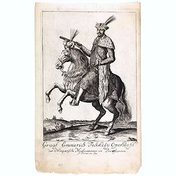
Graaf Emmerics Tekkelÿ Opperhoofd . . .
Equestrian portrait of Emmerics Tekkelÿ, full-length in profile to left but looking at the viewer, horse seen in frontal view, after Pieter Stevens ( c.1683-1692)This is...
Date: Antwerp, c.1690
Selling price: ????
Please login to see price!
Sold in 2019

Julius Franciscus D.G. Saxon . . .
Equestrian portrait of Julius Franciscus, full-length in profile to left but looking at the viewer, horse seen in frontal view, after Pieter Stevens ( c.1683-1692).This i...
Date: Antwerp, c.1690
Selling price: ????
Please login to see price!
Sold in 2019

Johannes III D.G. Polonorum . . .
Equestrian portrait of Johannes III, full-length in profile to left but looking at the viewer, horse seen in frontal view, after Pieter Stevens ( c.1683-1692).This is one...
Date: Antwerp, c.1690
Selling price: ????
Please login to see price!
Sold in 2018

Carel de 2 door G. G Koning van Spangien.
Equestrian portrait of Carel de 2nd, full-length in profile to left but looking at the viewer, horse seen in frontal view, after Pieter Stevens ( c.1683-1692).This is one...
Date: Antwerp, c.1690
Selling price: ????
Please login to see price!
Sold in 2019
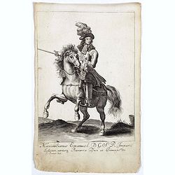
Maximilianus Emanuel D. G. S R Imperii Elector Bavaria.
Equestrian portrait of Maximilianus Emanuel, full-length in profile to left but looking at the viewer, horse seen in frontal view, after Pieter Stevens ( c.1683-1692).Thi...
Date: Antwerp, c.1690
Selling price: ????
Please login to see price!
Sold in 2019
![Del Palatinato, et Elettorato Del Reno Parte Orientale... [and] Descritta Dal P. Coronelli Cosmografo della Serema. Repuca.](/uploads/cache/81112-250x250.jpg)
Del Palatinato, et Elettorato Del Reno Parte Orientale... [and] Descritta Dal P. Coronelli Cosmografo della Serema. Repuca.
A large 2-sheet, detailed and decorative map of the Rhine Valley from Coronelli’s Corso Geografico Universale, published in Venice in 1690.The map shows the eastern par...
Date: Venice, 1690
Selling price: ????
Please login to see price!
Sold in 2018

Ernest Rudiger, Grave van Starrenberg . . .
Equestrian portrait of Ernest Rudiger, full-length in profile to left but looking at the viewer, horse seen in frontal view, after Pieter Stevens ( c.1683-1692) was milit...
Date: Antwerp, c.1690
Selling price: ????
Please login to see price!
Sold in 2018
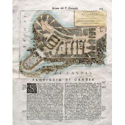
Castello di Candia descritto, e dedicato. . .
An uncommon engraved plan of the castle of Candia (Heraklion, Crete) on a large sheet with Italian text below and on verso. From Coronelli's famous Isolario atlas. Corone...
Date: Venice, ca. 1690
Selling price: ????
Please login to see price!
Sold in 2018
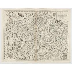
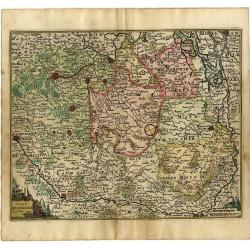
Marcomania Hoggidi Marchesato de Moravia Detto Volgarmente Marnhem. . .
A lovely map of Moravia centered on Brno and filled with well-engraved mountains, forests, coats of arms and cities. The map is dedicated to Andrea Bragadin within the el...
Date: VENICE, 1690
Selling price: ????
Please login to see price!
Sold in 2021
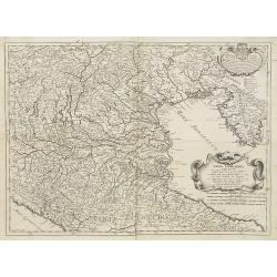
Exactissima Tabula Qua Tam Danubii Fluvii Pars Superior. . .
A highly detailed map of the Upper Danube and the Sea of Liguria (or Genoa), published by Nicolaus Visscher in 1690. The map extends from the headwaters of the Danube in ...
Date: Amsterdam, 1690
Selling price: ????
Please login to see price!
Sold in 2019
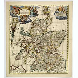
Exactissima regni Scotiae tabula. . .
A superb map of Scotland by Visscher, published in Amsterdam at the end of the seventeenth century. All the Scottish counties are colored in outline. There is a tremendou...
Date: Amsterdam, 1690
Selling price: ????
Please login to see price!
Sold in 2019
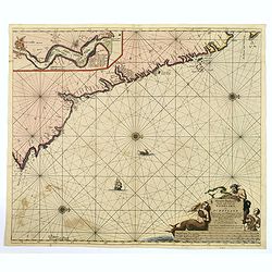
Nieuwe Pas-kaert vande Oost Kust van Engeland en Schotland. . .
A delightful Dutch maritime chart that includes the east coast of England, running from Berwick in Northumberland, southwards to Burlington in Yorkshire. A nice inset map...
Date: Amsterdam, 1690
Selling price: ????
Please login to see price!
Sold in 2019
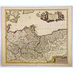
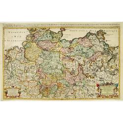
Marchionatus Brandenburgi et Ducatus Pomeraniae Tabula. . .
An attractive map of Brandenburg and Pommeren. Embellished with a title-cartouche with winged putti, fronds and a pair of coats-of-arms, plus a cartouche with three sets ...
Date: Amsterdam, 1690
Selling price: ????
Please login to see price!
Sold in 2019
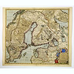
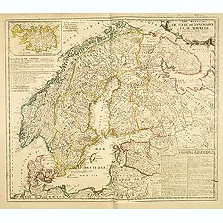
Regni Sueciae Tabula Generalis, divisia in Suediae, Gothiae. . .
An attractive and detailed map of Scandinavia, centered on Finland, including parts of Sweden, Norway and Russia. Nicely colored to accentuate the seas, mountains, lakes ...
Date: Amsterdam, 1690
Selling price: ????
Please login to see price!
Sold in 2019
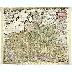
Regni Poloniae et Ducatus Lithuaniae Voliniae, Podoliae..
Standard map of Poland.
Date: Amsterdam, 1690
Selling price: ????
Please login to see price!
Sold in 2019
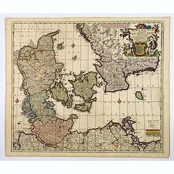
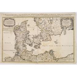
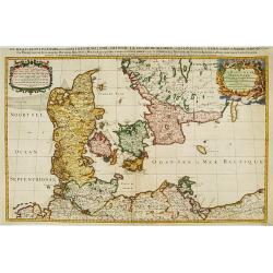
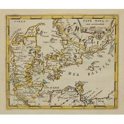
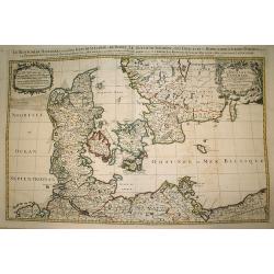
Dania Regnum In quo sunt Ducatus Holsatia et Slesvicum Iutia, et Insule, dictae Danicae. . .
An attractive map centered on Denmark and including southern tip of Sweden. Enhanced by a very ornamented title cartouche in the upper right-hand corner. colored mileage ...
Date: Amsterdam ca 1690
Selling price: ????
Please login to see price!
Sold in 2020
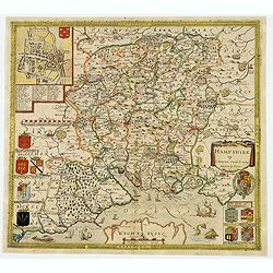
Hampshire.
Christopher Saxton’s sumptuous county map of Hampshire together with the northern part of the Isle of Wight, first issued in 1575, 'Corected & many Additions by P. ...
Date: London, ca 1690
Selling price: ????
Please login to see price!
Sold in 2021
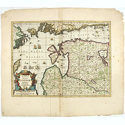
Nova Totius Livoniae accurata Descriptio.
The excellent, and decorative map of Livonia from the Moses Pitt "The English Atlas". Map extent is southern most tip of Sweden, part of the southern coast of F...
Date: Oxford, 1690
Selling price: ????
Please login to see price!
Sold in 2023
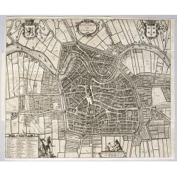
Harlemum, vulgo Haerlem, by Gregorio Leti, 1690.
A detailed and very decorative bird's-eye view of the Dutch city of Haarlem, with the city's and the province's coats of arms, together with two decorative cartouches at ...
Date: Amsterdam, 1690
Selling price: ????
Please login to see price!
Sold in 2020
Candia.
A bird's eye view of the town of Heraklion, in Crete, engraved by Bouttats, G. Showing the siege of the Turks in 1667.
Date: Antwerp, ca. 1690
Selling price: ????
Please login to see price!
Sold in 2020
Novissima Artesiae Comitatus Tabula.
A fine original color example of Justus Danckerts map of Artois in France, published in Amsterdam in 1690. It features a decorative cartouche with eight putti.Justus Danc...
Date: Amsterdam, 1690
Selling price: ????
Please login to see price!
Sold in 2022
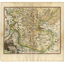
LA TRANSILVANIA. . .
A beautiful map of the Transilvanian regions in Romania, depicting several kingdom's crests around the map.
Date: Venetia, 1690
Selling price: ????
Please login to see price!
Sold in 2020
Ducatus Lutzenburgici Tabula Nuperrime in Lucem Edita per F. de Wit.
Frederick de Wit's handsome map of Luxembourg in fine original coloring. Frederik de Wit (1610-98), Amsterdam-based cartographer and publisher. 'Atlas minor', 1670,' Zee-...
Date: Amsterdam, ca 1690
Selling price: ????
Please login to see price!
Sold in 2020
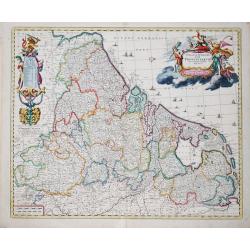
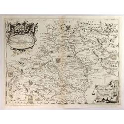
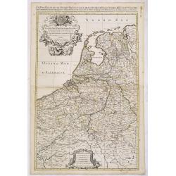
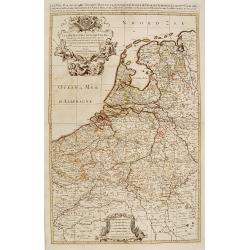
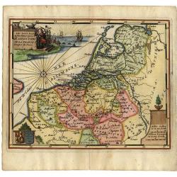
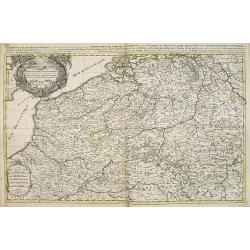
Germaniae Inferioris XVII PROVINCIARUM Accuratissima Tabula.
The third state of Nicolaas Visscher I's attractive map of the XVII Provinces of the Netherlands, published by his son Nicolaas II. Embellished with a large and decorativ...
Date: Amsterdam, ca 1690
Selling price: ????
Please login to see price!
Sold in 2023
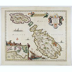
Insularum Melitae vulgo Maltae et Gozae. . .
A very attractive example of this detailed map of Malta and Gozo with inset map of the Western Mediterranean. Sailing ships and a large title cartouche with the Coat of A...
Date: Amsterdam, 1690
Selling price: ????
Please login to see price!
Sold in 2022
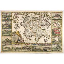
Peloponnesus Hodie Moreae Regnum Distincte Divisum in Omnes suas Provincias . . . Insulae Cefalonia, Zante, Cerigo et St. Maura Acore F. De Wit.
A rare, spectacular map in fine period color of the Peloponnese surrounded by 14 large city, port and fortress views and plans of important Greek cities including Athens,...
Date: Amsterdam, 1690
Selling price: ????
Please login to see price!
Sold in 2022
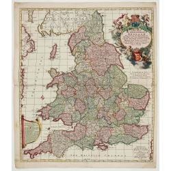
A New Mapp of the Kingdome of England.
Very decorative map of England and Wales by Nicolaes Visscher II, comes from the atlas “Atlas Minor, sive geographia compendiosa qua orbis terrarum. . . ”.
Date: Amsterdam, c. 1690
Selling price: ????
Please login to see price!
Sold in 2022
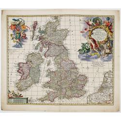
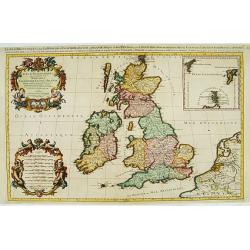
Magnae Britanniae Tabula; Comprehendens Angliae, Scotiae ac Hiberniae Regna
Very decorative map of Great Britain by Nicolaes Visscher II, dedicated to William III, King of England, Scotland and Ireland.Map comes from the atlas “Atlas Minor, siv...
Date: Amsterdam, c. 1690
Selling price: ????
Please login to see price!
Sold in 2023
![[ Lot of 9 maps and plans] Novissima nec non Perfectissima Scandinaviae Tabula](/uploads/cache/18177-(3)-250x250.jpg)
[ Lot of 9 maps and plans] Novissima nec non Perfectissima Scandinaviae Tabula
Frederick de Wit's large and detailled map of Scandinavia. Embellished with a large, decorative title-cartouche.From Frederick de Wit's' Atlas Maior'. Frederik de Wit (16...
Date: Amsterdam, 1690
Selling price: ????
Please login to see price!
Sold in 2022
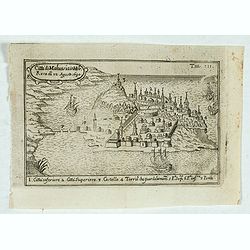
Citta di Malvasia in Mora Reas di 12 Agosto 1690.
Bird's-eye view of the island of Malvasia, nowadays called Monemvasia, with part of the eastern shore of the Peloponnese, showing the island fortress of Monemvasia in Gre...
Date: Italy, after 1690
Selling price: ????
Please login to see price!
Sold in 2023
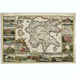
Peloponnesus Hodie Moreae regnum..
A rare, spectacular map of the Peloponnese surrounded by 14 large city, port and fortress views and plans of important Greek cities including Athens, Sparta, Lepanto, Mod...
Date: Amsterdam, 1690
Selling price: ????
Please login to see price!
Sold in 2023
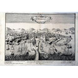
Coppenhague Ville Capitale du Royaume de Danemarck est située en Zeelande qui est une des Isles de la Mer BALTIQUE
Very rare, large decorative view of Copenhagen. The view shows an elaborate waterfront image, with wharves, windmills, shipbuilding, etc. 7 major sites are identified in ...
Date: Paris?, ca 1690
Selling price: ????
Please login to see price!
Sold in 2023
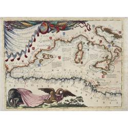
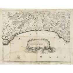
Ristretto del Mediterraneo...
Very large, extremely decorative map of the Western part of the Mediterranean Sea. It is embellished with coats of arms and decorative cartouches, Vincenzo Maria Coronell...
Date: Venice, 1690
Selling price: ????
Please login to see price!
Sold in 2023
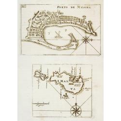
Porto de Mesina I. Malta.
An attractive map of the port of Porto de Mesina and the island of Malta. Most decorative.The remarkable Vincenzo Coronelli (1650-1718), encyclopaedist, geographer, inven...
Date: Venice 1691
Selling price: ????
Please login to see price!
Sold
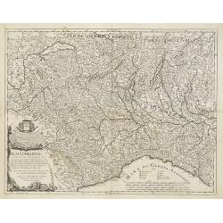
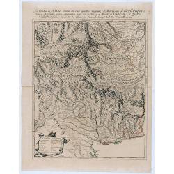
Alta Lombardia e stati ad essa circonuicini . . .
Uncommon late 17th century map of part of the Lombardy region, based on the reports of Giacomo Cantelli da Vignola and published in Roma in Giacomo de Rossi's world atlas...
Date: Rome, ca.1691
Selling price: ????
Please login to see price!
Sold in 2009
![[ Adriatic Sea and the Gulf of Venice. ]](/uploads/cache/27404-250x250.jpg)
[ Adriatic Sea and the Gulf of Venice. ]
A late 17th century coastline map of the Adriatic Sea and the Gulf of Venice, based on the reports of Giacomo Cantelli da Vignola and published in Rome in Giacomo de Ross...
Date: Rome, ca. 1691
Selling price: ????
Please login to see price!
Sold in 2009
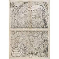
![[Two maps] Il Piemonte . . . Ducato di Monferrato . . .](/uploads/cache/27406-250x250.jpg)
[Two maps] Il Piemonte . . . Ducato di Monferrato . . .
A set of two late 17th century maps of the Piedmont region and the hills of Montferrat and Langhe in the north-western corner of Italy, between the Alps and the Riviera, ...
Date: Rome, 1691
Selling price: ????
Please login to see price!
Sold in 2009
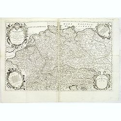
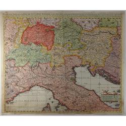
Germania Parte Occidentale, Dedicata Al Reuerendissimo Padre D. Serafino Pasolino Nella Congreg Lateranense ...
Detailed map of Western Europe by Vincenzo Coronelli, showing the Holy Roman Empire. This beautiful map covers from the Baltic in the north to Venice in the south. In the...
Date: Venice, 1691
Selling price: ????
Please login to see price!
Sold in 2014
Les Royaumes De Suede, de Danemarck et De Norwege Divisez en plusieurs Provincez, et Gouvernemens, etc. selon les Memoires de Bxxx de Scheffer, et de plusieurs autres Corrigee et augmentez apr le Sr. de Tillemon . . .
Rare map of Scandinavia and the Baltic with inset map of Iceland. Published by Jean Baptiste Nolin, the Geographer to the King of France. With large text panels giving ge...
Date: Paris, 1691
Selling price: ????
Please login to see price!
Sold in 2014
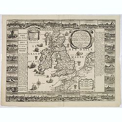
Nouvelle carte d'Angleterre avec les royaumes d'Ecosse et d'Irlande . . .
Decorative and very rare "carte ?? figures"- map of the British Isles by Fran?ois Jollain (ca. 1641 – 18 April 1704). In the center of the map the British Isl...
Date: Paris, 1691
Selling price: ????
Please login to see price!
Sold in 2013
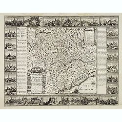
Nouvelle carte de Savoye et Piemont . . .
Detailed and decorative "carte à figures"- map of Lombardy / Savoye, including a part of Switzerland and Italy and published by François Jollain (ca. 1641 –...
Date: Paris, 1691
Selling price: ????
Please login to see price!
Sold
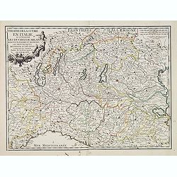
Theatre de la guerre en Italie ou se trouvent les Duchez de Milan. . .
Rare map of the northern part of Italy, including the towns of Rurin, Milan, Verona, Trente, Modena, Ravenna, Geneva, etc. Published by François Jollain (ca. 1641 – 18...
Date: Paris, 1691
Selling price: ????
Please login to see price!
Sold in 2023
La Contea di Nizza divisa ne suoi quattro vicariati . . .
Giacomo Rossi's fine late 17th century map of Nizza province. . The principal settlements, mountain ranges and rivers are shown in detail.Read more about Giovanni Giacomo...
Date: Rome, 1691
Selling price: ????
Please login to see price!
Sold in 2021
Li Grisoni già detti Rheti . . .
Fine example of this scarce map of northern Italy and Southern Switzerland, published by Coronelli in his Corso Geogrpaphico.The map extends from Lago di Como and the nor...
Date: Venice, 1691
Selling price: ????
Please login to see price!
Sold in 2020

Isola di Malta, olim Melita..
The island of Malta surrounded by 62 engraved armorials, including the arms of the Grand Masters of the Order of St John. Most decorative.The remarkable Vincenzo Coronell...
Date: Venice, 1691
Selling price: ????
Please login to see price!
Sold in 2022
Le royaume de Danemark.
Fine map of Denmark with a decorative title and scale cartouche.Alexis-Hubert Jaillot (1632-1712), was a French cartographer. He joined the Sanson heirs and redrew Nicola...
Date: Amsterdam, 1692
Selling price: ????
Please login to see price!
Sold in 2013
Les Provinces des Pays-Bas Catholiques . . . Le Roy de France, le Roy d'Espagne, et les Etats Généraux des Provinces-Unies . . .
Fine map of the Catholic Netherland Provinces with a decorative armorial cartouche and small scale of miles.Alexis-Hubert Jaillot (1632-1712), was a French cartographer. ...
Date: Amsterdam, 1692
Selling price: ????
Please login to see price!
Sold in 2013
Les Dix-Sept Provinces des Pays-Bas..
Map of the present-day Benelux by Hubert Jaillot.
Date: Paris 1692
Selling price: ????
Please login to see price!
Sold
La Savoia divisa nelle sue Principali Provincie da Giacomo Cantelli da Vignola . . .
A set of two late 17th century maps of the Savoye region, based on the reports of Giacomo Cantelli da Vignola and published in Roma in Giacomo de Rossi's world atlas Merc...
Date: Rome, 1692
Selling price: ????
Please login to see price!
Sold in 2013
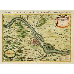
Plan de la ville de Vienne et ses environs par le Sr. Sanson.
Large scale map of Vienna and its environs. Prepared by Sanson and published by Jaillot.
Date: Paris 1692
Selling price: ????
Please login to see price!
Sold
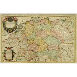
L'Empire d'Allemagne ..
Large scale map of Germany, The Netherlands, Belgium, Luxemburg, Poland and Austria. Prepared by Sanson and published by Jaillot.Very large and decorative piece.
Date: Paris 1692
Selling price: ????
Please login to see price!
Sold
Les Isles Britanniques qui contiennents les- Royaumes, d' Angleterre, Escosse, et Irlande.
Large scale map of England, Scotland and Ireland. To the left inset map of Shetland Islands, Orcades and Orkney.Prepared by Sanson and published by Jaillot.Very large and...
Date: Paris 1692
Selling price: ????
Please login to see price!
Sold
Le cercle de la basse Saxe..
Large scale map of Northern Germany, with Berlin, reaching as far as Poland, with Stettin.Prepared by Sanson and published by Jaillot.Very large and decorative piece.
Date: Paris 1692
Selling price: ????
Please login to see price!
Sold
Le Royaume de Danmark.
Large scale map of Denmark. Prepared by Sanson and published by Jaillot.Very large and decorative piece.
Date: Paris 1692
Selling price: ????
Please login to see price!
Sold
Ducatus Brunsuicensis. . . Calenbergicum, Grubenhag..
With numerous coats of arms of principal cities all over the map.The cartouche is painted in a strong and a somewhat impressionistic way. Varnish is used for the dark sha...
Date: Nurmberg, 1692
Selling price: ????
Please login to see price!
Sold in 2018
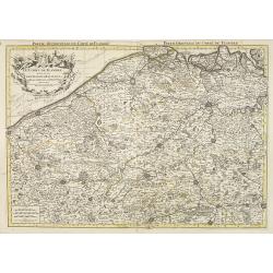
Comitatus Flandriae
Small map of the west part of Belgium locating major rivers and cities.
Date: Antwerp, 1692
Selling price: ????
Please login to see price!
Sold
Les Pays Bas.
Small map of the Netherlands and Belgium, with a decorative scene in the corner.
Date: Antwerp, 1692
Selling price: ????
Please login to see price!
Sold
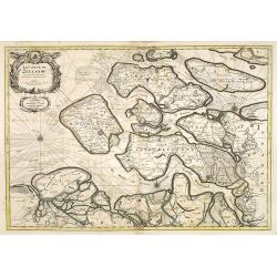
Over-Yssel
Small map of the East part of The Netherlands.
Date: Antwerp, 1692
Selling price: ????
Please login to see price!
Sold
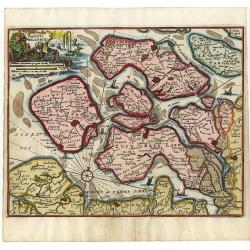
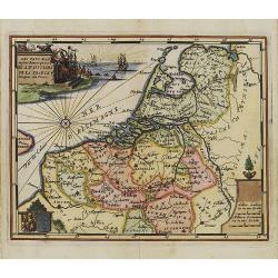
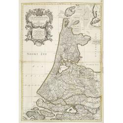
Comitatus Zelandiae
Small map of the South-West part of The Netherlands.
Date: Antwerp, 1692
Selling price: ????
Please login to see price!
Sold
Ducatus Brabantiae
Small map of the Southern part of The Netherlands.
Date: Antwerp, 1692
Selling price: ????
Please login to see price!
Sold
Tran-siselana.
A most attractive and decorative map by Vincenzo Coronelli. An elaborate title cartouche garlanded with intertwined flowers and dedicated to Antonio Martinelli. The remar...
Date: Venice 1692
Selling price: ????
Please login to see price!
Sold
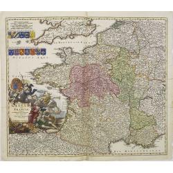
Totius Regni Galliae sive Franciae..
A finely engraved detailed map of France with imposing title cartouche and coats of arms. °
Date: Nuremberg, 1692
Selling price: ????
Please login to see price!
Sold in 2011
Danemarq et Sud-Gothlande.
Lovely small map of Denmark.
Date: Antwerp, 1692
Selling price: ????
Please login to see price!
Sold in 2011
Les Pays Bas.
Small map of the Netherlands and Belgium, with a decorative scene in the corner. Engraved by Jacob Harrewijn.
Date: Antwerp, 1692
Selling price: ????
Please login to see price!
Sold in 2008
Le Royaume de Danemark subdivisé en ses Principales Provinces..
Handsome map of Denmark and part of Sweden.
Date: Paris, 1692
Selling price: ????
Please login to see price!
Sold in 2009
![[The Parma Duchy].](/uploads/cache/27388-250x250.jpg)
[The Parma Duchy].
A uncommon late 17th century map of part of the Parma Duchy in Italy, based on the reports of Giacomo Cantelli da Vignola and published in Roma in Giacomo de Rossi's worl...
Date: Rome, ca. 1692
Selling price: ????
Please login to see price!
Sold in 2009
Parte Seconda Maritima del Patrimonio di S. Pietro . . .
An uncommon late 17th century map of part the Patrimony of S. Peter on the Adriatic coast, based on the reports of Giacomo Cantelli da Vignola and published in Roma in Gi...
Date: Rome, ca. 1692
Selling price: ????
Please login to see price!
Sold in 2009
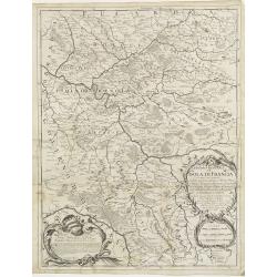
Governo Generale dell' Isola di Francia . . .
In lower left hand corner a large ornamental title cartouche. A late 17th century map of Isle de France region, centered on Paris. Prepared by Giacomo Cantelli da Vignola...
Date: Rome, 1692
Selling price: ????
Please login to see price!
Sold in 2009
Bassa Lombardia . . .
Map of the Lombardy region in Northern Italy, dated 1681. In upper left corner a decorative dedicational cartouche. Lower right a title cartouche.Based on the reports of ...
Date: Rome, ca. 1692
Selling price: ????
Please login to see price!
Sold in 2009
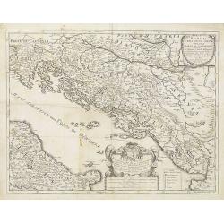
Dalmatia Istria Bosnia Servia Croatia parte di Schiavonia . . .
A late 17th century coast line map of Gulf of Venice and the Adriatic Sea in southern Central Europe bordering Italy to the west, the Adriatic Sea to the southwest, Croat...
Date: Rome, ca. 1692
Selling price: ????
Please login to see price!
Sold in 2009
Veue du Port et des Envirions de Ville Franche ...
Rare early map of Villefranche-sur-Mer near Nice in southern France. Includes Mont Boron (here called Monbourone) and the peninsula of Saint-Jean-Cap-Ferrat. Finely exec...
Date: Paris, 1692
Selling price: ????
Please login to see price!
Sold in 2009
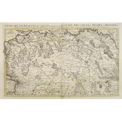
Le Duché de Brabant, qui comprend les Quartiers de LOUVAIN, BRUSSELLES, ANVERS, et BOSLEDUC . . .
Fine map of the present-day Dutch province of North Brabant. The map notes Nicolas Sanson as the mapmaker and claims that the map was published by Alexis-Hubert Jaillot (...
Date: Amsterdam, 1692
Selling price: ????
Please login to see price!
Sold in 2009
Les Provinces des Pays-Bas Catholiques . . . Le Roy de France, le Roy d'Espagne, et les Etats Généraux des Provinces-Unies . . .
Fine map of present day Belgium with a decorative title and scale cartouche.The map notes Nicolas Sanson as the mapmaker and claims that the map was published by Alexis-H...
Date: Amsterdam, 1692
Selling price: ????
Please login to see price!
Sold in 2015
Le Comte de Flandre divisé en ses Chastellenies et Balliages &c le Franc de Bruges et le Pays de Waes. . .
Fine map of the province of Flanders in present-day Belgium, ornated with a rococo title cartouche.Boundaries are outlined in hand color. The map is fully and richly engr...
Date: Amsterdam, 1692
Selling price: ????
Please login to see price!
Sold in 2023
Le Comté de Zeelande . . .
Fine map of the province of Zeeland ornated with a rococo title cartouche with the coat of arms of Zeeland showing a lion half-emerged from water.Boundaries outlined in h...
Date: Amsterdam, 1692
Selling price: ????
Please login to see price!
Sold in 2009
Comte de Hollande dresse sur les Memoires les plus Nouveaux . . .
Fine map of the province of Holland, ornated with a rococo title cartouche incorporating five scales. This cartouche has also a dedication to Le Dauphin with his coat of ...
Date: Amsterdam, 1692
Selling price: ????
Please login to see price!
Sold in 2018
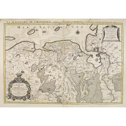
La Seigneurie de Groningue . . .
Fine map of the Groningen in the northern part of the Netherlands with a decorative armorial cartouche and small scale.Alexis-Hubert Jaillot (1632-1712), was a French car...
Date: Amsterdam, 1692
Selling price: ????
Please login to see price!
Sold in 2013
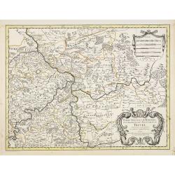
Partie Orientale du Temporel de l'Archevesché et Eslectorat de Treves . . .
Fine map of Trier with a figurative title and scale cartouche.The French name of the city of Trier, in Germany.Alexis-Hubert Jaillot (1632-1712), was a French cartographe...
Date: Amsterdam, 1692
Selling price: ????
Please login to see price!
Sold in 2021