Browse Listings in Europe
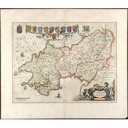
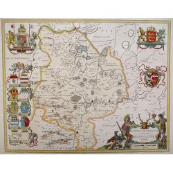
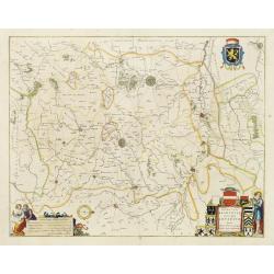
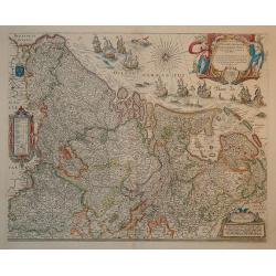
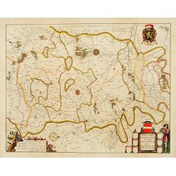
Penbrochia Comitatus et Comitatus Caermaridunum
Attractive map of the country of Pembrokeshire in UK by J. Blaeu. From a Dutch edition of "Atlas Maior" in beautiful color. br>With 13 coats of arms, one car...
Date: Amsterdam, 1648
Selling price: ????
Please login to see price!
Sold in 2008
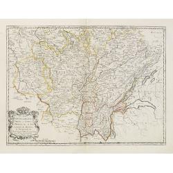
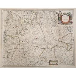
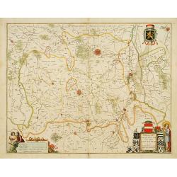
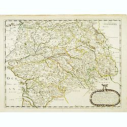
Les Deux Bourgognes Duché et comté la Bresse &c. la Souveraineté de Dombes, le Nivernois &c..
Fine map of Burgundy.This edition carries the date 1648.Nicolas Sanson was to bring about the rise of French cartography, although the fierce competition of the Dutch wou...
Date: Paris, 1648
Selling price: ????
Please login to see price!
Sold
![[Astrakan to Parskylan]](/uploads/cache/28797-250x250.jpg)
[Astrakan to Parskylan]
Showing the region of the Cremea, from Astrakan to Parskylan.
Date: 1648
Selling price: ????
Please login to see price!
Sold in 2010
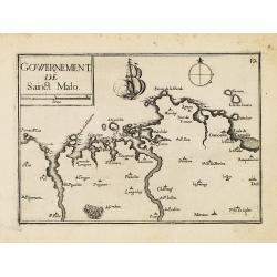
Gowernement de Saint Malo.
Nice map centered on St. Malo from Tassin's desirable and scarce Atlas "Cartes generales de toutes les Provinces de France et d'Espaigne..." published by Berey ...
Date: Paris, Bery, 1648
Selling price: ????
Please login to see price!
Sold in 2010
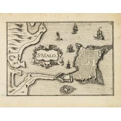
St Malo.
Nice town-plan of St. Malo from Tassin's desirable and scarce Atlas "Cartes generales de toutes les Provinces de France et d'Espaigne..." published by Berey in ...
Date: Paris, Berey, 1648
Selling price: ????
Please login to see price!
Sold in 2010
Stato Di Milano.
Engraved map with Dutch text on verso, Covers the area of Italy from the lakes in the north to Regiano to the south centered on Milan.
Date: Amsterdam, 1648
Selling price: ????
Please login to see price!
Sold in 2016
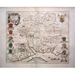
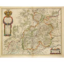
HUNTINGDONENSIS COMITATUS, HUNTINGTON SHIRE
A highly attractive and finely copper plate engraved 17th century map This example bears French text to the verso and the usual excellent quality coloring.
Date: Amsterdam, 1648
Selling price: ????
Please login to see price!
Sold in 2013
Hantonia Sive Southantonensis Comitatus Vulgo Hantshire
A very attractive Blaeu map of Hampshire. The map is embellished with royal coat of arms, and also of earls of Winchester and Southampton. Latin text on verso.
Date: Amsterdam, 1648
Selling price: ????
Please login to see price!
Sold in 2013
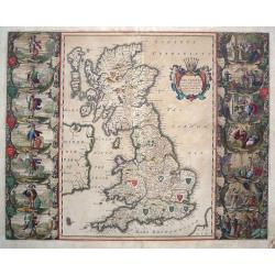
Britannia Prout Divisa Suit Temporibus Anglo-Saxonum.
An impressive and decorative historical map of the British Isles with the seven Anglo-Saxon kingdoms, Northumbria, Mercia, East Anglia, Essex, Kent, Sussex and Wessex. Ea...
Date: Amsterdam, 1648
Selling price: ????
Please login to see price!
Sold in 2014
Estats du Czar ou Grand Duc de la Russie Blanche ou Moscovie.
Eastern portion of Sanson's two-sheet map of Russia and White Russia, extending from the Gulf of Finland to the Caspian Sea and Central Asia. A nice example.Engraved by A...
Date: Paris, 1648
Selling price: ????
Please login to see price!
Sold in 2017
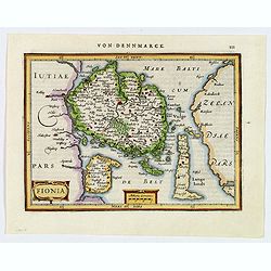
Fionia.
A pretty map of Fionia (Funen) from the Mercator Hondius “Atlas Minor” published in Amsterdam in 1648 (with Janssonius) with German text on verso. In 1607, Jodocus Ho...
Date: Amsterdam, ca 1648
Selling price: ????
Please login to see price!
Sold in 2019
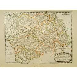
![Les Deux Bourgognes, Duché et Comté, la Bresse & la Souveraineté de Dombes, le Nivernois, &c. [Proof state ]](/uploads/cache/44009-250x250.jpg)
Les Deux Bourgognes, Duché et Comté, la Bresse & la Souveraineté de Dombes, le Nivernois, &c. [Proof state ]
Rare proof state of Sanson' map "Les Deux Bourgognes, Duché et Comté, la Bresse & la Souveraineté de Dombes, le Nivernois, &c", printed without title...
Date: Paris, c. 1648
Selling price: ????
Please login to see price!
Sold in 2021
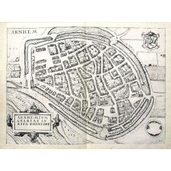
Arnhemium Gelriae in Ripa Rheni Opp.
A bird's eye view plan of Arnhem, Gelderland. After Lodovico Guicciardini by J. Janssonius. Filled with buildings and details. With the coat of arms and a title cartouche...
Date: Amsterdam, 1648
Selling price: ????
Please login to see price!
Sold in 2019
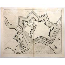
Gravia obsessa et expugnata armis ordinum Belgicae..
A military map showing Grave and the surrounding area with fortifications. With a decorative title cartouche, a blank cartouche with two figures and a military scene vign...
Date: Amsterdam 1649
Selling price: ????
Please login to see price!
Sold
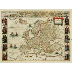
Europa recens descripta.
On either side columns depicting the manner of dress in the major countries of Europe, surmounted by nine city views and plans. For European mapmakers their own continent...
Date: Amsterdam 1649
Selling price: ????
Please login to see price!
Sold
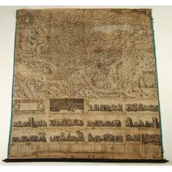
Urbis Romae Sciographia ex Antiquus Monumentis Accuratiss. Delineata.
Large wall map of the most famous plan of Ancient Rome. The plate in 8 sheets is engraved by and first published by Stephanus Du Perac in 1574: re-published by Villamena ...
Date: Rome, after 1649
Selling price: ????
Please login to see price!
Sold
Silesia Inferior.
Johannes Janssonius, the great rival of Willem Blaeu, was the son-in-law of Jodocus Hondius. Together with Jodocus' son Hendrick, he continued to publish the successive e...
Date: Amsterdam, 1649
Selling price: ????
Please login to see price!
Sold in 2009
Ducatus Silesiae Glogani Vera Delineatio. Iona Sculteta Sprotta.
Johannes Janssonius, the great rival of Willem Blaeu, was the son-in-law of Jodocus Hondius. Together with Jodocus' son Hendrick, he continued to publish the successive e...
Date: Amsterdam, 1649
Selling price: ????
Please login to see price!
Sold in 2009
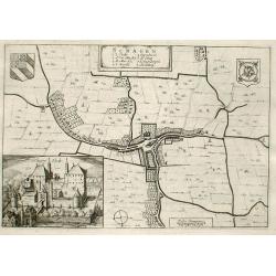
Schagen
Fine map of the town of Schagen with inserted a nice engraving of the Castle of Schagen.Copper engraving from Joan Blaeu's Toneel der Steden (townbook) 1649.Dutch text on...
Date: Amsterdam 1649
Selling price: ????
Please login to see price!
Sold
Breda Obsessa Et Expugnata a Celsissimo Friderico Henrico.
Fine map of Breda and environs to show the siege of the town by Frederik Hendrik, Prince of Orange, in 1637. Lower left a decorative cartouche with a dedication and coats...
Date: Amsterdam, 1649
Selling price: ????
Please login to see price!
Sold in 2013
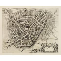
Amisfurtum. (Amersfoort)
A bird's-eye view of the town.
Date: Amsterdam 1649
Selling price: ????
Please login to see price!
Sold
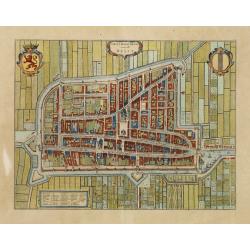
Delfi Batavorum vernacule Delft.
Detailed plan of the city Delft from Joan Blaeu's town book of the Netherlands, first published one year after the peace of Munster and the Spanish acknowledgement of the...
Date: Amsterdam, 1649
Selling price: ????
Please login to see price!
Sold in 2010
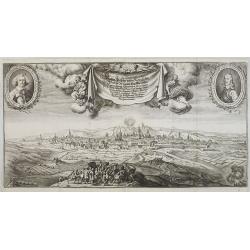
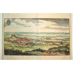
Wahrer Abriz der beijden Königlichen haubt Stadt und New Stadtt Prag . . .
Large decorative panoramic view of Prague, prepared by Carlo Sereta and engraved and published by Matthaeus Merian, in the 'Topographia Bohemiae'. Very decorative and of ...
Date: Frankfurt, 1649
Selling price: ????
Please login to see price!
Sold in 2009
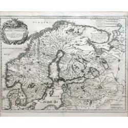
Tabula exantissima Regnoru Suecia et Norvegia
Finely detailed map showing Scandinavia (Denmark, Sweden, Norway, Finland), and White Sea region with a pretty cartouche in the upper left.
Date: Frankfurt, 1649
Selling price: ????
Please login to see price!
Sold in 2010
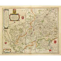
Le Diocese de Tournay ou font Exactement Marquees Les Lignes.
Fine map of northern French region around the city of Tournay (Tournay-sur-Odon). The region depicted on the map extends from Valenciennes and Douay (Douai) in the south ...
Date: Paris, 1649
Selling price: ????
Please login to see price!
Sold in 2010
Epirus hodie vulgo Albania Autore I. Laurenbergio.
A fine copper plate engraving in original hand color of a historical map of Albania and Epirus in Greece. Numerous islands and ships are drawn in the clearly marked Ionia...
Date: Amsterdam, c.1649
Selling price: ????
Please login to see price!
Sold in 2010
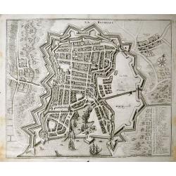
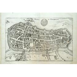
La Rochelle.
Superbly engraved of La Rochelle by Merian. The birds-eye view shows the city with its buildings, city walls, the harbour with sailing ships and shipbuilders, and the su...
Date: Paris, 1649
Selling price: ????
Please login to see price!
Sold in 2011
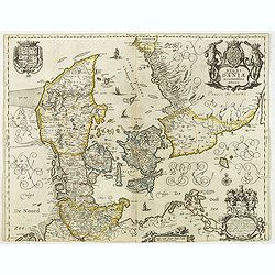
Regni Danemark daniae accuratissime delineatio.
Detailed map of Denmark in a first state, without the names of the dioceses in Jutland added in the second state. Three beautiful cartouches with a dedication to Gerardus...
Date: Amsterdam, 1644-1649
Selling price: ????
Please login to see price!
Sold in 2012
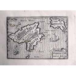
Majorcae et Minorcae descrip.
Superb miniature map of the Balearics. Including a sailing ship, sea monsters, and the title cartouche. After Barent Langenes from his Caert-Thresoor. Very rare and at...
Date: Amsterdam, 1649
Selling price: ????
Please login to see price!
Sold in 2013
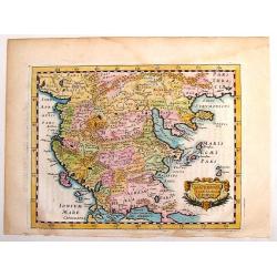
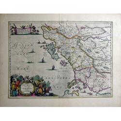
Macedonia Thessalia Epirus.
Fine detailed map of Macedonia by Briet. Decorated with strapwork cartouche. Philippe Briet (1601 - 1668) was a French Jesuit priest, a writer and a mapmaker. His “Par...
Date: Paris, 1649
Selling price: ????
Please login to see price!
Sold in 2013
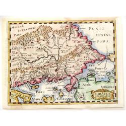
Thraciae Delinieatio.
Detailed copper engraved map of Thracia, Greece with portions of Bulgaria and Turkey. Small title cartouche in the bottom right.Philippe Briet (1601 - 1668) was a French ...
Date: Paris, 1649
Selling price: ????
Please login to see price!
Sold in 2014
Germaniae Antiquae Adiecta.
A pleasant, little, detailed, copper engraved map of ancient Germany. It is enhanced by a strapwork cartouche featuring the face of a cherub.Philippe Briet (1601 - 1668) ...
Date: Paris, 1649
Selling price: ????
Please login to see price!
Sold in 2016
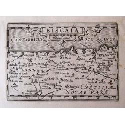
BISCAIA.
Detailed miniature map of Biscay, including Oviedo, Palencia, Burgos, Santander, Bilbao, Logroño...From Visschers reissue of the "Caert-Thresoor": "Tabula...
Date: Amsterdam, 1649
Selling price: ????
Please login to see price!
Sold in 2014
Europa exactissime descripta.
Embellished with two cartouches, several ships and a sea-monster, polar bears and lions. Now with the imprint of Henricus Hondius and the date 1631. With Dutch text on ve...
Date: Amsterdam, 1631-1649
Selling price: ????
Please login to see price!
Sold in 2019
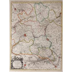
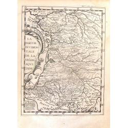
Partie Orientale de la Grande Aquitaine.
Detailed map from the "THEATRE DE L'EUROPE GEOGRAPHIQUE" published in Paris by Pierre Mariette in 1649. The engraver was Phillippe Briet (1601-1668) the Jesuit ...
Date: Paris, 1649
Selling price: ????
Please login to see price!
Sold in 2016
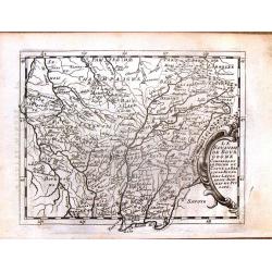
Le Royaume de Bourgogne Comprenant le Duche et Contre la Bresse le Nivernois, Lauxerrois, Dombes et Puysaye
Detailed map from the "THEATRE DE L'EUROPE GEOGRAPHIQUE" published in Paris by Pierre Mariette in 1649. The engraver was Phillippe Briet (1601-1668)the Jesuit p...
Date: Paris, 1649
Selling price: ????
Please login to see price!
Sold in 2014
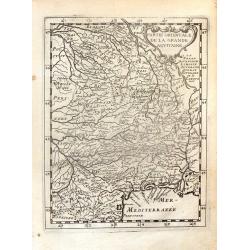
La Partie Occidentale de la Grade Aquitaine.
Detailed map from the "THEATRE DE L'EUROPE GEOGRAPHIQUE" published in Paris by Pierre Mariette in 1649. The engraver was Phillippe Briet (1601-1668) the Jesuit ...
Date: Paris, 1649
Selling price: ????
Please login to see price!
Sold in 2016
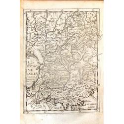
Le Royaume darles comprenant la Provence Daulphine, Savoye & Lionnois.
Detailed map from the "THEATRE DE L'EUROPE GEOGRAPHIQUE" published in Paris by Pierre Mariette in 1649. The engraver was Phillippe Briet (1601-1668)the Jesuit p...
Date: Paris, 1649
Selling price: ????
Please login to see price!
Sold in 2014
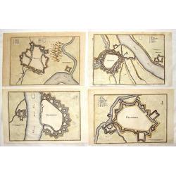
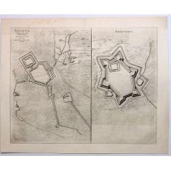
Four hand-colored fortification plans by Caspar Merian.
Four striking city and fortifications of Rhynberg, Wesel, Emmerich and Gelderen. Caspar Merian (1627-1686) was one of the most important topographical engravers of the Ba...
Date: Frankfurt, 1649
Selling price: ????
Please login to see price!
Sold in 2017
L'Allemagne Audeca du Rhin
A quaint and charming 367 year old map featuring the region of Germany and Luxemburg around the Rhine River from Lake Constance to Gueldre.
Date: Paris, 1649
Selling price: ????
Please login to see price!
Sold in 2019
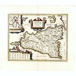
Siciliae veteris typus.
Map with two decorative cartouches featuring a globe, Neptune and his dolphins, angels and an eagle. Large inset of the harbor and city of Syracuse, contained in a third ...
Date: Paris, 1639-1649
Selling price: ????
Please login to see price!
Sold in 2022
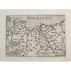
Normandia.
Detailed miniature map of Normandy. With Caen, Rouen, Amiens,... Extends to include Jersey and Mont-Saint-Michel.From Visschers reissue of the Caert-Thresoor: "Tabul...
Date: Amsterdam, ca. 1649
Selling price: ????
Please login to see price!
Sold in 2017
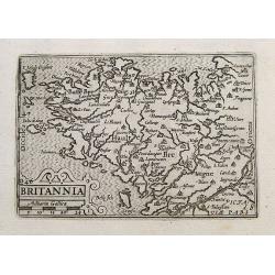
Britannia.
Detailed miniature map of Bretagne. Locates Rennes, Nantes, Brest, Quimper, and many others. Includes Mont-Saint-Michel, Ile Ouessant, Belle-Ile, and Île de Sein.From Vi...
Date: Amsterdam, ca. 1649
Selling price: ????
Please login to see price!
Sold in 2020
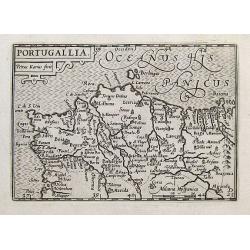
Portugallia.
Highy detailed miniature map of Portugal with parts of Spain. With Lagos, Lisbon, Porto, Vigo, and many more place names. Includes the Berlengas, shown much exaggerated i...
Date: Amsterdam, c1649
Selling price: ????
Please login to see price!
Sold in 2020
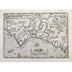
Valentia.
Detailed miniature map of South-East Spain. Includes Alicante, Valencia, and a tip of Ibiza. With a small sailing ship and a sea-monster.From Visschers reissue of the Cae...
Date: Amsterdam, ca. 1649
Selling price: ????
Please login to see price!
Sold in 2019
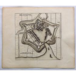
Blockzyl.
Birds-eye view of Blokzijl and it's fortifications by Blaeu. Blokzijl is a city located southwest of Steenwijk in the province of Overijssel, the Netherlands. Blokzijl gr...
Date: Amsterdam, c1649
Selling price: ????
Please login to see price!
Sold in 2018
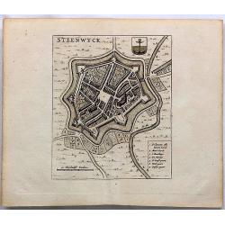
Steenwyck.
Fine birds-eye view of the fortified town of Steenwijk in the province of Overijssel, the Netherlands. Steenwiik grew in the 1580s. During the siege of Steenwijk, the...
Date: Amsterdam, ca.1649
Selling price: ????
Please login to see price!
Sold in 2023
Gravia Obsessa et Expugnata Armis Ordinum Belgicae Confoederate.
A military map showing Grave, Brabant,Netherlands and the surrounding area with fortifications. featuring a decorative title cartouche, a blank cartouche with two figures...
Date: Amsterdam, 1649
Selling price: ????
Please login to see price!
Sold in 2019
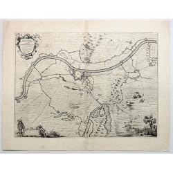
Stenovicum Obsessa ab Ordinibus Belgiae Foederatae.
Striking map of the siege of Steenwijk by Maurice in 1592.. Copper engraving, produced in 1649 in Amsterdam by Joan Blaeu from “Novum ac Magnum Theatrum Urbium Belgicae...
Date: Amsterdam, 1649
Selling price: ????
Please login to see price!
Sold in 2018
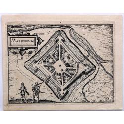
MarieBourg.
This bird's-eye plan of Mariebourg in Belgium illustrates the strategic position of its fortifications . It provides an excellent view of the city's defences, bridges, wa...
Date: Amsterdam, 1649
Selling price: ????
Please login to see price!
Sold in 2019
Brefurtum Capta Anno 1597 / Breevoort. (Bredevoort)
Plans of Breedevoort from the Townbook "Theatrum Urbium Belgicae" by Blaeu. Bredevoort is in the province of Gelderland in the Netherlands.Two engravings on one...
Date: Amsterdam, 1649
Selling price: ????
Please login to see price!
Sold in 2023
Doesburgh.
A nicely colored town plan of Doesburg in northeastern Holland, shown in an unusual panoramic birds-eye view, circa 1649. It features the fortress walls and a few cottage...
Date: Amsterdam, 1649
Selling price: ????
Please login to see price!
Sold in 2019
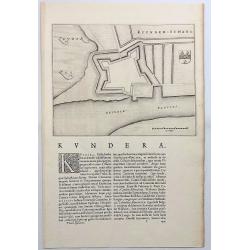
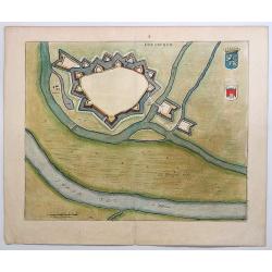
Kuynder-Schans.
Also known as “Kaart van de schans van Kuinre”. Kuinre is a village in the Dutch province of Overijssel located on the Zuyder Zee.It was a separate municipality until...
Date: Amsterdam, 1649
Selling price: ????
Please login to see price!
Sold in 2018

Stenovicum Obessa Ab Ordinibus Belgiae Foederatae...
A detailed map of the Siege of Steenwijk by Maurits in 1592. Steenwijk is located in the northern corner of the province of Overijssel, bordering on the Zuyder Zee, calle...
Date: Amsterdam, 1649
Selling price: ????
Please login to see price!
Sold in 2019
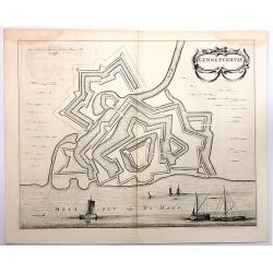
Genneperhuis.
Genneperhuis was a fortress at the mouth of the Niers River, near the town of Milsbeek, in the Dutch province of Limburg.This was the location of the Siege of the Gennepe...
Date: Amsterdam, 1649
Selling price: ????
Please login to see price!
Sold in 2018
Delfsill.
A plan of the town of Delfzijl, on the northern coast of Holland, shown in a panoramic birds-eye view. It features the walls of the fortress, but only one single church w...
Date: Amsterdam, 1649
Selling price: ????
Please login to see price!
Sold in 2018
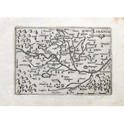
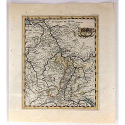
Limania.
A detailed miniature map of an area in the Département Puy-de-Dôme; Region Auvergne-Rhône-Alpes. Centered on the Allier river near Clermont-Ferrand and Pont-du-Châtea...
Date: Amsterdam, 1649
Selling price: ????
Please login to see price!
Sold in 2020
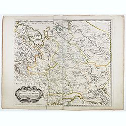
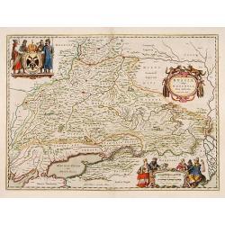
Le Royaume de Pologne..
Detailed map of Poland, including Lithuania, Moravia, Moldavia, etc. included in : Parallela Geographiae Veteris et Novae. / Parallela Geographiae Veteris et Novae by Phi...
Date: Paris, Sebastiani and Gabrielis Cramoisy, 1649
Selling price: ????
Please login to see price!
Sold in 2021
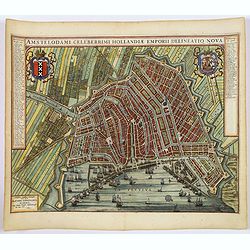
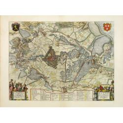
(Amsterdam)Amstelodami Celeberrimi Hollandiae Emporii delineatio nova.
A very attractive bird's-eye view of this most important European city, engraved at the height of the 'Golden Age' of Dutch cartography, when it sat at the hub of one of ...
Date: Amsterdam, 1649
Selling price: ????
Please login to see price!
Sold in 2019
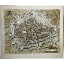
Middelburgum.
A fine city map in the style of a bird's eye of the city of Middelburg in Zeeland, Netherlands. Published in 1649 by Joan Blaeu in his 'Toonneel der Steden der Veenigde N...
Date: Amsterdam, 1649
Selling price: ????
Please login to see price!
Sold in 2021
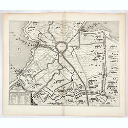
La siege de Hulst Per Son Altesse la Prince dOrangie 1645. / De belegeringe van de stadt Hulst.
This map of Hulst shows the siege and capture of the city in 1645 by a Dutch army led by Frederik Hendrik. The emphasis is on the siege machines surrounding the city. The...
Date: Amsterdam, 1649
Selling price: ????
Please login to see price!
Sold in 2021

Eiecitg Adam et collocauitante paradisium uouptatis cherubim . . . (Plate 7)
Very nice etching by Nicolas Chapron, after Raphaël's (Raffaello Sanzio) frescoes in the Vatican Loggia. Scene illustrating an angel casting Adam and Eve out of the para...
Date: Paris, Petrus Mariette, 1649
Selling price: ????
Please login to see price!
Sold in 2021
Russiae, vulgo Moscovia, pars Australis.
Centered on Moscow. Prepared by Isaac Massa, a Dutch mapmaker who travelled to Russia, returning to Holland in 1609, bringing with him a large amount of original cartogra...
Date: Amsterdam 1650
Selling price: ????
Please login to see price!
Sold
Iprensis Episcopatus.
Map of the Dioceses of Ypres (1559-1801). Centered on the towns of Ypres and Rouselare.Rare map only included in Joan Blaeu's Atlas Major. Originally engraved for Sanderu...
Date: Amsterdam, 1650
Selling price: ????
Please login to see price!
Sold in 2020
Edynburgum
A beautifully rendered 17th century view of Edinburgh. Provides excellent detail, with many of the town's key sites visible. The Scottish coat of arms is shown in the upp...
Date: Frankfurt, 1650
Selling price: ????
Please login to see price!
Sold
Reims en Champagne.
Detailed bird's-eye view of the town of Rheims. From Merian's Theatrum Europaeum. To the bottom a lettered key to the principal places in town.
Date: Frankfurt 1650
Selling price: ????
Please login to see price!
Sold
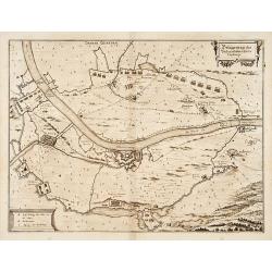
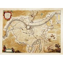
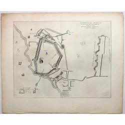
Belägerung des Vesten.. Gennep.
Detailed map of the siege of Gennep.
Date: Frankfurt 1650
Selling price: ????
Please login to see price!
Sold
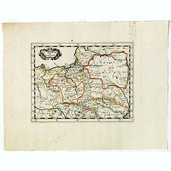
Prima pars Brabantiae cuius caput Lovanium.
Decorative map centred on Tienen and Leuven. West to the top.
Date: Amsterdam 1650
Selling price: ????
Please login to see price!
Sold in 2018
Novus XVII Inferioris Germanie Provinciarum Typus
This is undoubtedly one of the most magnificent maps of the seventeen provinces of the Netherlands. It was first produced as a separately issued wall map in 1608 with fig...
Date: Amsterdam, 1650
Selling price: ????
Please login to see price!
Sold in 2010
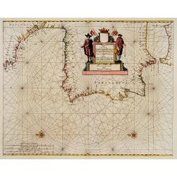
Pascaart vande Custen van Andaluzia, Portugal..
Decorative chart of the coasts of Andalusia, Portugal, Galicia, Biscayne from the first sea-atlas (in the real sense of the word) printed in the Netherlands.
Date: Amsterdam 1650
Selling price: ????
Please login to see price!
Sold
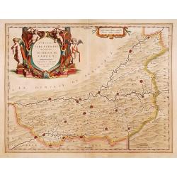
Dioecesis Sarlatensis, vernacule
Detailed map of Perigord, depicting Bergerac, Saint Cyprien, Montignac, Sarlat, Villefranche, etc. Embellished with an enormous and beautiful title cartouche in the left ...
Date: Amsterdam 1650
Selling price: ????
Please login to see price!
Sold
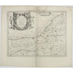
Dioecesis Sarlatensis, vernacule... Sarlat.
Impressive title cartouche with four putti. Detailed map of the region south of the Dordogne River from Bergerac till Saint-Cirq. Including Le Buisson.
Date: Amsterdam 1650
Selling price: ????
Please login to see price!
Sold in 2009
Prima pars Brabantiae cuius caput Lovanium.
Decorative map centered on Tienen and Leuven. West to the top.
Date: Amsterdam, 1650
Selling price: ????
Please login to see price!
Sold in 2018
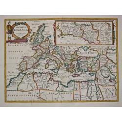
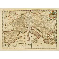
Imperium Romanum. Auth. Phil. Briet e Societ Iesu.
Philip Briet S.J. (1601-1668). French cartographer. Parallela Geogr. Veterus et Novae 1648, Atlas 1653.A map depicting the Roman Empire with an inset showing Rome and its...
Date: Paris, c. 1650
Selling price: ????
Please login to see price!
Sold
Prima pars Brabantiae cuius caput Lovanium.
Decorative map centered on Tienen and Leuven. West to the top. Prepared by Michael Floris van Langeren (1612-1675). He was an mathematician and astronomer who served for ...
Date: Amsterdam 1650
Selling price: ????
Please login to see price!
Sold
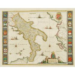
Regno di Napoli.
To the left and right 12 coats of arms of different regions. From a German text edition.
Date: Amsterdam 1650
Selling price: ????
Please login to see price!
Sold
Gouvernement General d'Orleans ..
Fine map of south eastern part of France, including Isle de Ré, Paris, S.Malo, etc. This edition carries the date 1650 and the cartouche presents the address of Pierre M...
Date: Paris, 1650
Selling price: ????
Please login to see price!
Sold
Imperium Caroli Magni
Finely engraved map of the Empire of Karol the Great.
Date: Amsterdam 1650
Selling price: ????
Please login to see price!
Sold
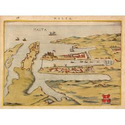
Malta.
Attractivetown-plan of Valetta on Malta, based on the engraving in Braun and Hogenberg' townbook from 1572-1624.A schematic drawing shows Valetta with a strongly fortifie...
Date: The Netherlands ? 1650
Selling price: ????
Please login to see price!
Sold
Gouvernement General d'Orleans ..
Fine map of south eastern part of France, including Isle d'Ré, Paris, S.Malo, etc.This edition carries the date 1650 and the cartouche presents the address of Pierre Mar...
Date: Paris 1650
Selling price: ????
Please login to see price!
Sold