Browse Listings in Europe
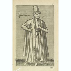
Gentilhomme Grec. (31)
Sought-after copper engraved plate from Laonikos Chalcocondyle’s "L'histoire de la décadence de l'empire grec et establissement de celuy des Turcs." by Thoma...
Date: Paris, Mathieu Guillemot, 1650
Selling price: ????
Please login to see price!
Sold in 2011
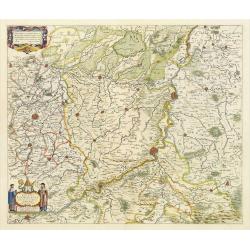
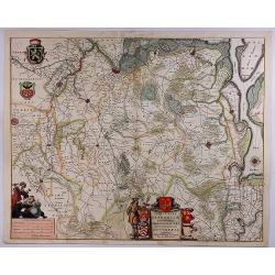
Dioecesis Leodiensis
Detailed map of Belgium. Embellished an allegorical title cartouche surrounded by a coat of arms. Shows the Maas, part of Belgium next to Brabant. Cities include Liege, M...
Date: Amsterdam, c. 1650
Selling price: ????
Please login to see price!
Sold in 2023
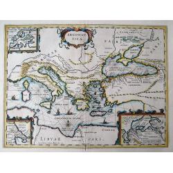
ARGONAUTICA
This decorative map illustrates the geography of the Golden Fleece legend in the Mediterranean, covering from Italy to the Black Sea. The Argonautica is a Greek epic poem...
Date: Amsterdam, c1650
Selling price: ????
Please login to see price!
Sold in 2011
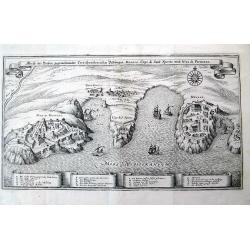
Abriß der Dreyen, gegeneinander Correspondierenden Vestungen Monaco, Capo di Sant Spirito, und Niza die Provenza.
Nice view of the coast in southern France, from Nice to Monaco, including Villefranche-sur-Mer and Saint-Jean-Cap-Ferrat! A very decorative and informative map, with t...
Date: Frankfurt, c1650
Selling price: ????
Please login to see price!
Sold in 2011
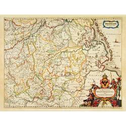
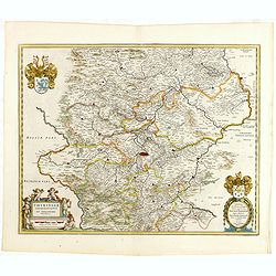
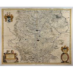
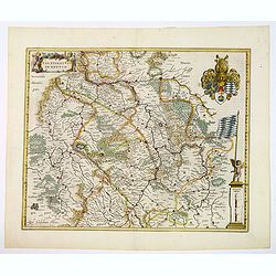
Circulus Westphalicus sive Germaniae Inferioris.
West to the top. Detailed map of the northern part of Germany far south to Düsseldorf and Waldeck and Paderborn.Lower right imposing title cartouche with inset map of Ha...
Date: Amsterdam, 1650
Selling price: ????
Please login to see price!
Sold in 2013
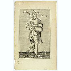
Villageois Grec. (20)
Sought-after copper engraved plate of a musician from Greece. Plate from Laonikos Chalcocondyle’s "L'histoire de la décadence de l'empire grec et establissement d...
Date: Paris, Mathieu Guillemot, 1650
Selling price: ????
Please login to see price!
Sold in 2012
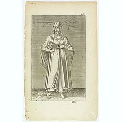
Femme Déstat Grecque de la Ville de Pera. (47)
Sought-after copper engraved plate of a woman from Greece. Plate from Laonikos Chalcocondyle’s "L'histoire de la décadence de l'empire grec et establissement de c...
Date: Paris, Mathieu Guillemot, 1650
Selling price: ????
Please login to see price!
Sold in 2012
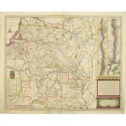
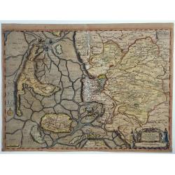
Magni Ducatus Lithuaniae Caetrarumq Regionum illi Adiacentium exacta decrip. . .
Detailed map of Lithuania, Poland and part of Russia up to the River Dnepr, based upon Blaeu's four sheet map. Highly detailed, extending from Cracow to the Baltic in the...
Date: Amsterdam, 1650
Selling price: ????
Please login to see price!
Sold in 2018
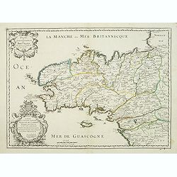
Duche et Gouvernement de Bretagne.
First state of this decorative map of Bretagne, including the cities of Nantes, Rennes, Belle-Île, etc. engraved by Robert Cordier d'Abbauil. The map is dated 1650. In t...
Date: Paris, ca.1650
Selling price: ????
Please login to see price!
Sold
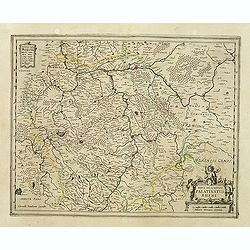
Nova descriptio Palatinatus Rheni.
Detailed map of Germany centered of Manheim. An extremely rare map finely engraved. The map is copied by Cornelis Danckerts II after a map by Henricus Hondius. This map a...
Date: Amsterdam, ca. 1650
Selling price: ????
Please login to see price!
Sold in 2023
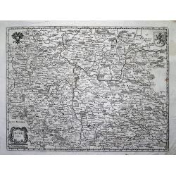
Bohemia (Map showing Rübezahl, Giants + Dragon)
Shows the Riesengebirge (Montes Gigantium - mountains of giants), and showing "Ribenzal" (Rübezahl) as figures and a dragon(?). Rare old copper engraving of B...
Date: ?, c1650
Selling price: ????
Please login to see price!
Sold in 2012
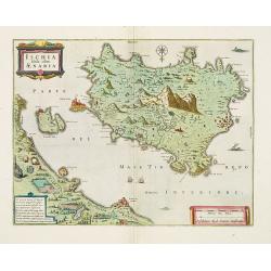
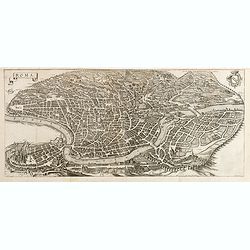
Ischia, quae olim Aenaria.
Prepared by Giulio Iasolino (1537-1622), who wrote a book about Ischia in 1568 and its beneficial baths which included a map of the island, which Ortelius and later Janss...
Date: Amsterdam, 1650
Selling price: ????
Please login to see price!
Sold in 2013
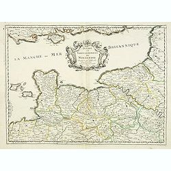
Duche et gouvernement de Normandie.
Fine map of Normandy, with the islands of Jersey and Guernsey. Engraved by R. Cordier d'Abbauil. This edition carries the date 1650. Nicolas Sanson was to bring about the...
Date: Paris, 1650
Selling price: ????
Please login to see price!
Sold
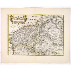
.Catalogne et Arragon.
Early imprint of this fine map of Catalonia. With decorative cartouches for the title and scale. Included in " Theatre geographique de France contenant les cartes pa...
Date: Paris, 1650
Selling price: ????
Please login to see price!
Sold in 2016
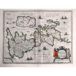
Insularum Britannicarum Acurata Delineatio ex Geographicis Conatibus Abraham Ortelii.
This is Jansson's historical map of the British Isles giving credit to Abraham Ortelius in the title. Engraved by Peter van den Keere. North is oriented to the right. H...
Date: Amsterdam, c1650
Selling price: ????
Please login to see price!
Sold in 2013
Palatina tus ad Rhenum.
A lovely, super-decorated, detailed map of Germany with "three" cartouches depicting "seven" putti plus a coat of arms. The cities, including Bingen, ...
Date: Amsterdam, 1650
Selling price: ????
Please login to see price!
Sold in 2016
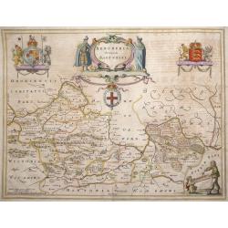
Bercheria vernacule. . . (Barkshire)
‘Bercheria vernacule’ - Barkshire by Joannes Blaeu. A very decorative map, with armorials and escutcheons.
Date: Amsterdam, 1650
Selling price: ????
Please login to see price!
Sold in 2013
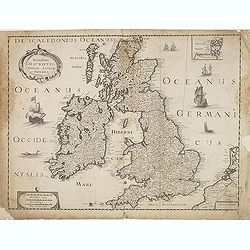
Novissima descriptio Angliae Scotiae et Hiberniae.
Uncommon map of Great Britain and Ireland.
Date: Paris, c. 1650
Selling price: ????
Please login to see price!
Sold in 2015
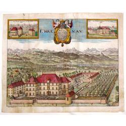
Ehrenau.
Striking detailed, copper engraving of a view of Schloss Ehrenau, Austria. There is a wonderful cartouche featuring two cherubs, a crown and a coat of arms. In addition t...
Date: Germany, 1650
Selling price: ????
Please login to see price!
Sold in 2016
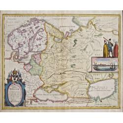
Tabula Russiae.
Map shows total Russia with Scandinavia.
Date: Frankfurt on Main, 1650
Selling price: ????
Please login to see price!
Sold in 2014
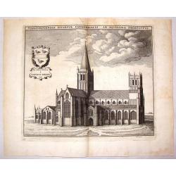
Herfordiensis Ecclesiae Cathedralis Ab Aquilone Prospectus.
Striking copper engraving of Herford Cathedral by Wenceslaus Hollar. It was created in about 1650 for Sir. W. Dugdale of England for his well known book featuring British...
Date: London, c1650
Selling price: ????
Please login to see price!
Sold in 2015
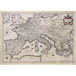
Imperium Caroli Magni.
Nice large map showing the Empire of Karol the Great.
Date: Amsterdam, 1650
Selling price: ????
Please login to see price!
Sold in 2017
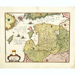
Livonia vulgo Lyefland.
Showing the Baltic region with present-day Estonia, Latvia and Lithuania, with the Baltic Sea, as well as the neighboring coastlines of Sweden and Finland. Based on a map...
Date: Frankfurt, 1650
Selling price: ????
Please login to see price!
Sold in 2018
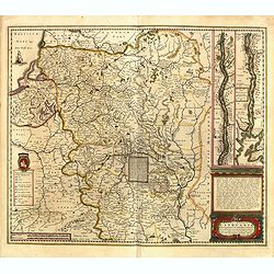
Magni Ducatus Lithuaniae Caetrarumq Regionum illi Adiacentium exacta decrip. . .
Detailed map of Lithuania, Poland, and part of Russia up to the River Dnepr, based upon Blaeu's four-sheet map. Highly detailed, extending from Cracow to the Baltic in th...
Date: Amsterdam, 1650
Selling price: ????
Please login to see price!
Sold in 2017
Roma.
Large and detailed bird's-eye town-view of Rome, published and engraved by Matthaeus Merian around 1641. With city arms to the top right corner. One of the most beautiful...
Date: Frankfurt, 1650
Selling price: ????
Please login to see price!
Sold in 2017
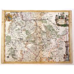
Thuringia landgraviatus...
Detailed map of Thuringa centered on Erfurd on the middle of the map. Showing also Weimar. Embellished with a very decorative title cartouche surrounded by six cherubs. I...
Date: Amsterdam, 1650
Selling price: ????
Please login to see price!
Sold in 2016
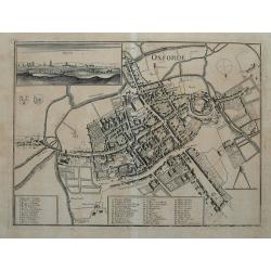
Oxforde.
Superbly detailed plan of Oxford with hundreds of tiny buildings, numerous fields, and rivers. With 48 places, streets, bridges, churches, and colleges identified through...
Date: Frankfurt, c1650
Selling price: ????
Please login to see price!
Sold in 2015
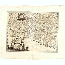
Riviera di Genova di Levante.
Detailed map of the Gulf of Genoa, including the towns of Genoa and La Spezia. Genoa was the birthplace of Christopher Columbus.
Date: Amsterdam, 1650
Selling price: ????
Please login to see price!
Sold in 2015
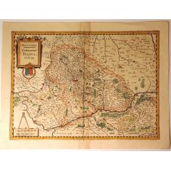
Beauvaisis, Comitatus Belovacium
A pleasing map of the Beuavais region of France. Decorative title cartouche with royal arms and drapery style scale cartouche with compass. Johannes Janssonius (1588-16...
Date: Amsterdam, 1650
Selling price: ????
Please login to see price!
Sold in 2018
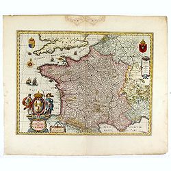
GALLIA. Le royaume de France.
The map was first published with figured borders (1607). When Blaeu needed a folio size map of France for his first atlas (Appendix 1631) he cut off the borders. The same...
Date: Amsterdam, 1650
Selling price: ????
Please login to see price!
Sold in 2016
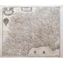
Languedoc
A great map of southern France from Perpignan to just east of the mouth of the Rhone river, until Étang de Berre. Filled with place names, including Avignon, Arles, Caho...
Date: Amsterdam, ca. 1650
Selling price: ????
Please login to see price!
Sold in 2016
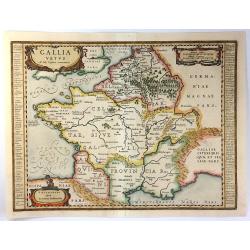
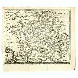
Gallia Vetus ad Iuly Caesaris Commentaria
This striking map of Gallia (ancient France) by Jan Jansson is based on information from Caesar's “De Bello Gallico". It is engraved to show the mountains, rivers ...
Date: Amsterdam, 1650
Selling price: ????
Please login to see price!
Sold in 2016
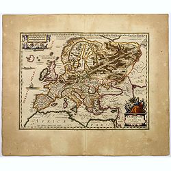
Europam, sive Celticam Veterem.
A map of the Celtic Empire by A. Ortelius, and reissued by Jansson in the middle of the seventeenth century. Ortelius' map first appeared in 1595.The map shows the contin...
Date: Amsterdam, ca 1650
Selling price: ????
Please login to see price!
Sold in 2017
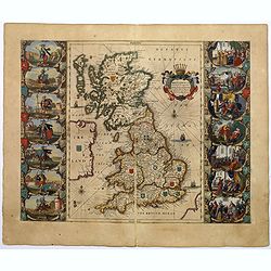
Britannia prout divisa suit temporibus Anglo-Saxonum, praesertim durante illorum Heptarchia.
A very decorative map of England, Scotland and Wales. Wales and Scotland have their own kingdoms, however, England is divided up into seven separate Saxon kingdoms.Northu...
Date: Amsterdam, ca 1650
Selling price: ????
Please login to see price!
Sold in 2018
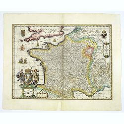
GALLIA. Le royaume de France.
Engraved by the master engraver Josua van den Ende. A very attractive map of France, embellished with a beautiful title cartouche at lower left, two royal shields in the ...
Date: Amsterdam, 1650
Selling price: ????
Please login to see price!
Sold in 2018
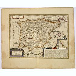
HISPANIAE Veteris descriptio.
A decorative handcolored copper engraved map, Latin text edition of J. Jansson's’ Historical Atlas'.
Date: Amsterdam ca. 1650
Selling price: ????
Please login to see price!
Sold in 2018
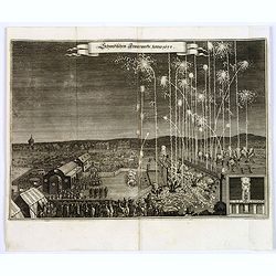
Schwedischen Feiverwerks, Anno 1650,
A night time fireworks display watched by an enthusiastic crowd, a print by M.Merian, published in his "Theatrum Europaeum." Banner title in German.
Date: Frankfurt am Main, 1650
Selling price: ????
Please login to see price!
Sold in 2019
Tertia Pars Brabantiae. . .
A striking map showing part of present-day Belgium and Dutch Brabant. West is at the top. At the lower left the cartouche is embellished with male figures with compasses,...
Date: Amsterdam, 1650
Selling price: ????
Please login to see price!
Sold in 2018
Thuringia Landgraviatus.
A detailed map of Thuringa in central Germany, centred on Erfurd on the middle of the map. Showing also Weimar. Embellished with a very decorative title cartouche that is...
Date: Amsterdam, 1650
Selling price: ????
Please login to see price!
Sold in 2018
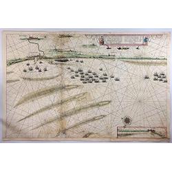
Afbeeldinge Vande vermaerde Seehaven ... Duynkerken...
A striking coastal chart, extending from Dunkerque and Wynoxbergen to in the east to Waldarn and Gravelines in the west, with an inset showing the continuation of the coa...
Date: Amsterdam, 1650
Selling price: ????
Please login to see price!
Sold in 2018
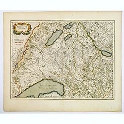
Das Wiflispurgergow.
A lovely detailed map of South-western Switzerland after Gerhard Mercator's map of the same. With an ornamental title cartouche and Dutch text on the verso. It shows Gene...
Date: Amsterdam, ca 1650
Selling price: ????
Please login to see price!
Sold in 2018
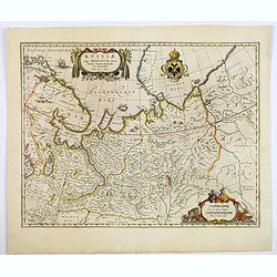
Russiae vulgo Moscovia dictae, Partes Septentionalis et Orientalis.
Covers the northern part of Russia from Finland to just beyond the Jenisej River and south to the Volga River. Includes the cities of Jaroslavl, Niznij Novgorod, and Kaza...
Date: Amsterdam, ca 1650
Selling price: ????
Please login to see price!
Sold in 2019
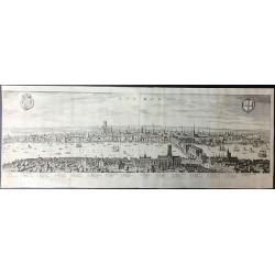
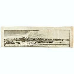
London.
A beautifully engraved panorama of London during the reign of James I which was based on an earlier Visscher engraving published in 1616.Merian's panorama shows London fi...
Date: London, 1650
Selling price: ????
Please login to see price!
Sold in 2019
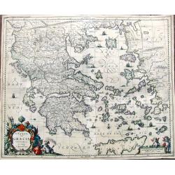
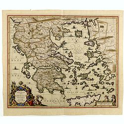
Hellas. seu Graecia Universa. Autore J. Laurenbergio.
Fine map of Greece with Crete, the Carpathian Sea, the islands west of Peloponesia, the Aegean Sea, and a part of Turkey. Richly detailed with towns, rivers, and topograp...
Date: Amsterdam, ca. 1650
Selling price: ????
Please login to see price!
Sold in 2019
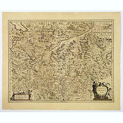
Comitatus Tirolensis.
A detailed map of the west Austrian Tirol region, with plenty of excellent topographical detail in the rendering of the numerous mountains, rivers, forests, larger towns,...
Date: Amsterdam, ca 1650
Selling price: ????
Please login to see price!
Sold in 2019
Avignon.
Detailed bird's-eye view of the town of Avignon.
Date: Frankfurt 1650
Selling price: ????
Please login to see price!
Sold in 2020
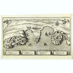
Abriß der Dreÿen, gegeneinander correspondierenden Vestungen, Monaco, Capo di Sant' Spirito, und Niza di Provenza. (Monaco)
Beautiful map showing the coasts of Provence, with detailed plans of Nice, Villefranche-sur-Mer, the peninsula of Cap Ferrat and Monaco, from the from the Theatrum Europ�...
Date: Frankfurt, ca. 1650
Selling price: ????
Please login to see price!
Sold in 2019
Silesia Inferior. . .
A fine and decorative map of lower Silesia (western Poland), centred on Glogau, the capital of Breslaw (Wroclaw) is found not far away. Each major city in the region is c...
Date: Amsterdam, 1650
Selling price: ????
Please login to see price!
Sold in 2019
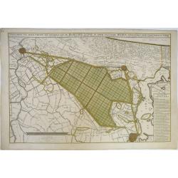
Afbeeldinge van Zeker Concept tot Bedykinge, van de Haarlemer, Leydse en Andere byleggende Meeren.
Large, rare, and detailed map of the region between Amsterdam, Haarlem and Leiden, from two copperplates. It concerns a concept to reclaiming the Haarlemmermeer, drawn by...
Date: Amsterdam, 1650
Selling price: ????
Please login to see price!
Sold in 2019
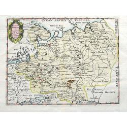
Russie Blanche ou Moscovie. . .
An unusual map of eastern Europe and western Russia. With two pages of descriptive text in French about the area on verso. Includes many cities and towns, rivers, and reg...
Date: Paris, ca 1650
Selling price: ????
Please login to see price!
Sold in 2019
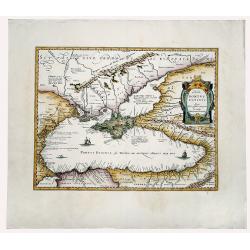
ΠΟΝΤΟΣ ΕΥΞΕΙΝΟΣ. PONTUS EUXINUS.
A striking example of the map depicting the Black Sea and the Crimean Peninsula with its surrounding regions. Covers parts of the Ukraine, Russia, Georgia, Romania and Tu...
Date: Amsterdam, ca 1650
Selling price: ????
Please login to see price!
Sold in 2020
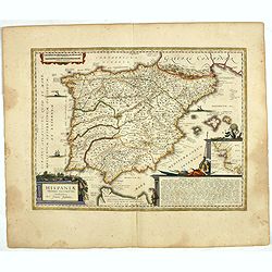
HISPANIAE Veteris descriptio. Abraham Goos Sculpsit.
A decorative handcolored copper engraved map, Latin text edition of J. Jansson's’ Historical Atlas'. A very handsome and decorative map of ancient Spain based on classi...
Date: Amsterdam ca. 1650
Selling price: ????
Please login to see price!
Sold in 2019

Duche et Gouvernement de Bretagne.
A probable first state of this decorative regional French map of Bretagne, including the cities of Nantes, Rennes, Belle-Île, St. Malo, Pontivy, Morlaix, Brest and Vanne...
Date: Paris, 1650
Selling price: ????
Please login to see price!
Sold in 2019
Palatinatus ad rhenum.
A beautiful, detailed map of the south western province of Rhineland-Palatinate in Germany by Blaeu, one of the most famous of all map publishers.A decorative map, coveri...
Date: Amsterdam, ca 1650
Selling price: ????
Please login to see price!
Sold in 2020
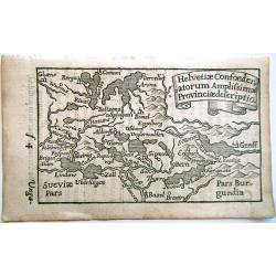
Helvetiae Confoederatorum Amplissimae Provinciae descriptio.
A scarce and charming miniature map of Switzerland from the first edition of Bucelin’s “Historiae universalis cum sacrae tum prophanae nucleus” published by Praetor...
Date: Ulm, 1650
Selling price: ????
Please login to see price!
Sold in 2020
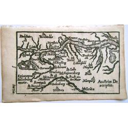
Austriae Descriptio.
A very rare and charming miniature map of Austria, covering the area of Vienna, Linz and Graz. From the first edition of Gabriel Bucelin's “Historiae universalis cum sa...
Date: Ulm, 1650
Selling price: ????
Please login to see price!
Sold in 2019
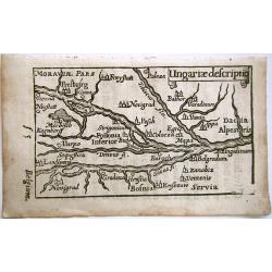
Ungariae descriptio.
A scarce and charming miniature map of Hungary from the first edition of Bucelin’s “Historiae universalis cum sacrae tum prophanae nucleus” published by Praetorius ...
Date: Ulm, 1650
Selling price: ????
Please login to see price!
Sold in 2020
Gallia Antiqua et Nova.
Uncommon map of ancient France. Very decorative and of the highest standing of engraving.
Date: Frankfurt, 1650
Selling price: ????
Please login to see price!
Sold in 2019
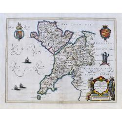
Comitatus Caernarvoniensis. . .
A fine Blaeu map of Caernarvonshire and Anglesey with present-day Gwynedd, including Bangor, Colwyn, Pwllheli, etc. Very detailed with many place names, hills, rivers, la...
Date: Amsterdam, ca 1650
Selling price: ????
Please login to see price!
Sold in 2020
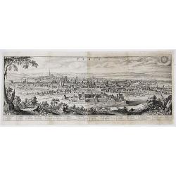
Parys.
Superb panorama of Paris by Merian. Paris is shown from Parc des Buttes-Chaumont looking towards the south west. The foreground includes a back-view self-portrait of the...
Date: Frankfurt, ca. 1650
Selling price: ????
Please login to see price!
Sold in 2020
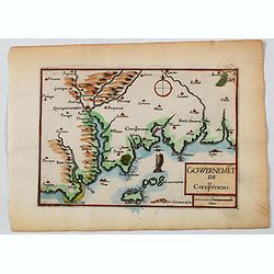
Gowernemet de Conquerneau.
A nice small map of the area of Concarneau, a commune in the Finistère department of Brittany in north-western France. Concarneau is bordered to the west by the Baie de ...
Date: Paris, ca 1650
Selling price: ????
Please login to see price!
Sold in 2021
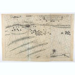
Afbeeldinge vande vermaerde seehaven ... Duynkerken..
Blaeu's chart of the coast of the French coast from Dunkirk till Waldamme. In an inset, lower right the continuation till Calais. Many ships offshore Dunkirk, with soundi...
Date: Amsterdam, 1650
Selling price: ????
Please login to see price!
Sold in 2020
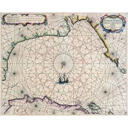
De Cust van Normandie en Picardie. . .
A rare sea-chart from Theunis Jacobsz, who called himself Lootsman. The Jacobsz family went on to be one of the most important commercial publishers of Dutch sea charts i...
Date: Amsterdam, ca 1650
Selling price: ????
Please login to see price!
Sold in 2021
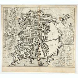
La Rochelle.
Detailed bird's-eye view of the town of La Rochelle. From Merian's Theatrum Europaeum. To the bottom, a lettered key to the principal places in town.
Date: Frankfurt, 1650
Selling price: ????
Please login to see price!
Sold in 2022
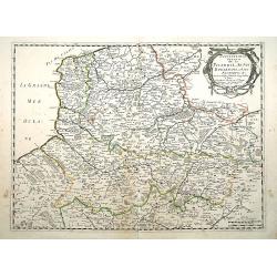
Gouvernement General de la Picardie, Artois,Boulenois..
"Fine map of France, centered on the provinces of Artois, Boulenois and Picardie. The cartouche presents the address of Pierre Mariette; rue St.Jacques a L'Esperance...
Date: Paris 1651
Selling price: ????
Please login to see price!
Sold
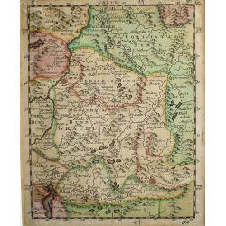
Graubunden.
Nice originally colored map of the Canton Graubunden or Graubunten. From the Atlas Minor.Below left the number of 1706. Upper right map number 36. Map shows Feldkirch in ...
Date: Atlas Minor 1607 - 1651
Selling price: ????
Please login to see price!
Sold
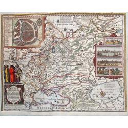
Tabula Russiae ex Mandato Foedor Borissowits Delineata. . .
Visscher version of Hessel Gerritsz' rare and important map of Russia, compiled from a manuscripts brought by Isaac Massa. The map covers the European part of the Russian...
Date: Amsterdam, 1651
Selling price: ????
Please login to see price!
Sold in 2013
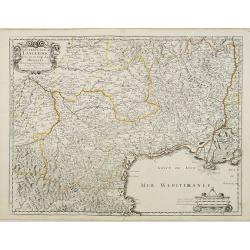
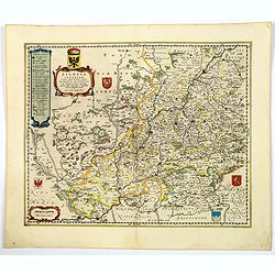
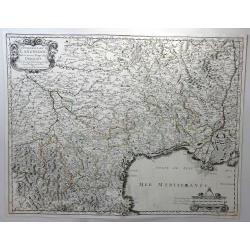
Gouvernem.t Gen.ral du Languedoc divisé en ses Vingt deux Diocèes.
Detailed map of the twenty two Languedoc dioceses. Title in an ornamental cartouche on upper left corner. On lower right corner small ornamental scale cartouche.Engraved ...
Date: Paris, 1651
Selling price: ????
Please login to see price!
Sold
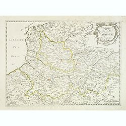
Gouvernement General de la Picardie, Artois, Boulenois. . .
Centered on the French provinces of Artois, Boulenois and Picardie. The cartouche presents the address of Pierre Mariette: rue St.Jacques a L'Esperance and the date 1651....
Date: Paris, 1651
Selling price: ????
Please login to see price!
Sold
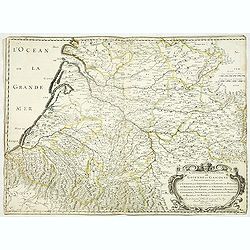
Gouvernement general de Guienne et Gascogne et pays circomvoisins ou sont la Guienne la Saintonge, le Limosin, le Perigort, le Rouergue, le Quercy et l'Agenois de ca la Garonne, la Gascogne, les Landes. . .
Early imprint of this fine map of south western part of France, engraved by R. Cordier d'Abbauil and dated 1651. Engraved by R.Cordier. Still with the address of Sanson &...
Date: Paris, 1651
Selling price: ????
Please login to see price!
Sold
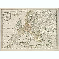
L'Europe. Par le S. Sanson d'Abbeville.
Fine map of Europe, with address of Pierre Mariette: rue st.Jacques a L'Esperance .Nicolas Sanson was to bring about the rise of French cartography, although the fierce c...
Date: Paris, 1651
Selling price: ????
Please login to see price!
Sold in 2013
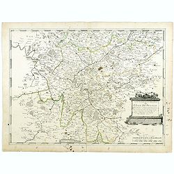
Gouvernement Général de L'Isle de France et pays circomvoisins. . .
A fine engraved map centered on Paris metropolitan area and its vicinities in the "Ile de France" region . Decorative title and scale cartouches. Engraved by Je...
Date: Paris, 1651
Selling price: ????
Please login to see price!
Sold
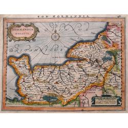
Normandia ducatus.
A map of Normandy from Mercator's Atlas Minor. German text about the region on verso. Extends to include also Saint-Malo & Mont-Saint-Michel.
Date: Amsterdam, 1651
Selling price: ????
Please login to see price!
Sold in 2016
Gouverement General du Languedoc, Divisee en ses Vingt Deux Dioceses.
A fine map of south-eastern part of France (Languedoc Roussillon), including the towns of Montpellier, Toulouse, Avignon, etc. Published in Paris by Sanson. This edition ...
Date: Paris, 1651
Selling price: ????
Please login to see price!
Sold in 2018
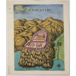
Paleocastro.
A copper engraved view of the Castle of Paleokastro, near Iraklion from Marco Boschini's "Il Regno tutto di Candia”. Marco Boschini, [1613-78] was a Venetian paint...
Date: Venice, 1651
Selling price: ????
Please login to see price!
Sold in 2022
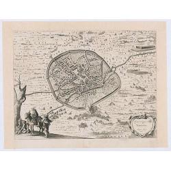
Veroveringe van Thienen Anno 1635
Birds eye view of the conquest of Tienen by the national army led by Frederik Hendrik, 1 June 1635, from : "I. Commelin, Frederick Hendrick van Nassauw Prince van Or...
Date: Amsterdam 1651
Selling price: ????
Please login to see price!
Sold in 2020
Das Ambt Tondern ohne Lundtoff Herde Anno 1648.
A very decorative, large, rare map of the northern coast of Germany and Denmark published by Casper Dankwerth in the famous, rare atlas "Newe Landesbeschreibung der ...
Date: Hossum, 1651
Selling price: ????
Please login to see price!
Sold in 2023
Hellas Seu Graecia Universa Autore J. Laurenbergio.
A decorative, detailed map of Greece, the western part of Turkey, and Macedonia. Lavishly colored and hightened with gold by the master colorist Dirk Jansz. van Santen..T...
Date: Amsterdam, ca.1652
Selling price: ????
Please login to see price!
Sold in 2019
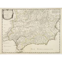
Les Etats de la couronne de Castille.. Andalousie..
Map of Andalusia, with original or early outline hand-color. Numerous place-names of counties, cities, towns, physical features. Prepared by N.Sanson and engraved by Somm...
Date: Paris 1652
Selling price: ????
Please login to see price!
Sold
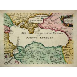
Mer Noire ou Mer Maievre.
Nicolas Sanson (1600-67), ' father of the French cartography' and founder of the Sanson firm. Atlas ' Cartes générales de toutes les parties du Monde', 1658-70 and a po...
Date: Paris, c. 1652
Selling price: ????
Please login to see price!
Sold