Browse Listings in Europe
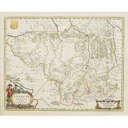
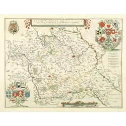
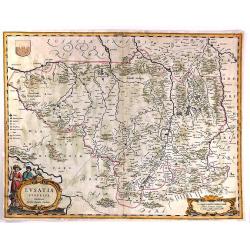
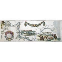
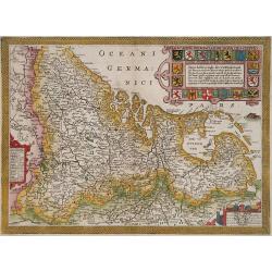
Lusatia Superior.
Attractive map of the region straddling present-day southwestern Poland, Saxony and the Czech Republic.Old city names including Lieba, Gorlitz, Dresden, Pirnaw, and Prybu...
Date: Amsterdam, 1647
Selling price: ????
Please login to see price!
Sold in 2011
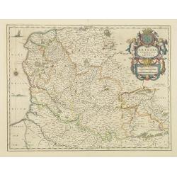
Artesia Comitatus. Artois.
Very decorative map of north-western part of France.As Willem Blaeu died in 1638 most of his maps are actually published by his son Joan. This maps carries his (engraved)...
Date: Amsterdam, 1647
Selling price: ????
Please login to see price!
Sold in 2011
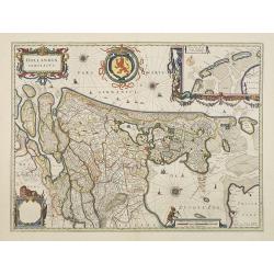
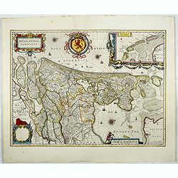
Hollandia Comitatus.
Orientated west to the top of the sheet, this represents the County of Holland in the classical orientation for seventeenth century maps, with Amsterdam at the centre. Th...
Date: Amsterdam, 1647
Selling price: ????
Please login to see price!
Sold in 2009
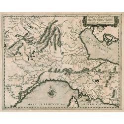
Tabula Alpium et Italiae a Basilea Romam...
Rare map from a book published by Hermannus Crombach. North Italy & Alps.
Date: Cologne, 1647
Selling price: ????
Please login to see price!
Sold in 2009
Galloflandria, in qua Castellaniae Lilana, duacena, et orchiesia, cum dependentibus ; necnon Tornacum, et Tornacesium / Auctore Martino Doué Gallo-Flandro
A very decorative map of the Gallic Flanders or Walloon Flanders comprising the Castellanies of Lille and Douai and the Tournaisis.
Date: Amsterdam, 1647
Selling price: ????
Please login to see price!
Sold in 2021
Leodiensis dioecesis.
West to the top. Fine map including the Dutch and Belgium provinces Limburg and the Belgium province of Namen and Ardennes. German text on verso.
Date: Amsterdam, 1647
Selling price: ????
Please login to see price!
Sold in 2018
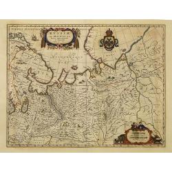
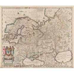
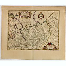
Russiae vulgo Moscovia dictae, Partes Septentrionalis. . .
In the north the Murmansk Sea. Including the western coast of Nova Zembla. Title cartouche and two cartouches, the bottom right one showing two hunters, bears, stags etc....
Date: Amsterdam, 1647
Selling price: ????
Please login to see price!
Sold in 2010
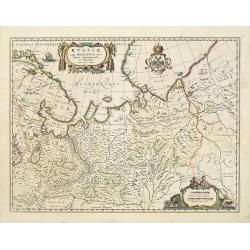
Russiae vulgo Moscovia dictae, Partes Septentrionalis. . .
In the north the Murmansk Sea. Including the western coast of Nova Zembla. Title cartouche and two cartouches, the bottom right one showing two hunters, bears, stags etc....
Date: Amsterdam, 1647
Selling price: ????
Please login to see price!
Sold in 2013
Oxonium Comitatus, Vulgo Oxford shire.
Double-page map of the county of Oxford on the Thames River. This English county map is highly decorative with figurative title cartouche of two scholars. Royal arms and ...
Date: Amsterdam, 1647
Selling price: ????
Please login to see price!
Sold in 2012
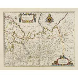
Russiae vulgo Moscovia dictae, Partes Septentrionalis. . .
In the north the Murmansk Sea. Including the western coast of Nova Zembla. Title cartouche and two cartouches, the bottom right one showing two hunters, bears, stags etc....
Date: Amsterdam, 1647
Selling price: ????
Please login to see price!
Sold in 2013
Flandria et Zeelandia Comitatus.
Includes Flanders and Zeeland. The map originally engraved in 1641 for Sanderus 'Flandria Illustrata', was used several times in Blaeu's atlases.
Date: Amsterdam, ca. 1647
Selling price: ????
Please login to see price!
Sold in 2012
Descriptio fluminum Rheni, Vahalis et Mosae.
Shows that part of the central Netherlands where the three great rivers flow to within but a few kilometers of each below Wesel. The scale allows most of the larger towns...
Date: Amsterdam, 1647
Selling price: ????
Please login to see price!
Sold in 2018
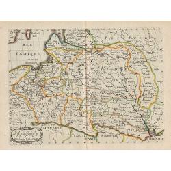
Estats de la Couronne de Pologne.
Map of Poland, from the first edition of the atlas L'Europe.Nicolas Sanson was to bring about the rise of French cartography, although the fierce competition of the Dutch...
Date: Paris, 1647
Selling price: ????
Please login to see price!
Sold in 2012
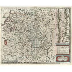
Magni Ducatus Lithuaniae ...
Decorative map of Poland and part of Russia up to the River Dnepr. Sailing ship, cartouche and coat of arms, plus a small mounted battle scene east of Brackaw and a secon...
Date: Amsterdam, 1647
Selling price: ????
Please login to see price!
Sold in 2012
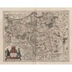
Poloniae Nova et Acurata Descriptio.
Decorative map of Poland, from Ioannis Ianssonni Novus Atlas, Sive Theatrum Orbis Terrarum : In quo Tabulae & Descriptiones omnium Regionum totius Universi accuratiss...
Date: Amsterdam, 1647
Selling price: ????
Please login to see price!
Sold in 2012
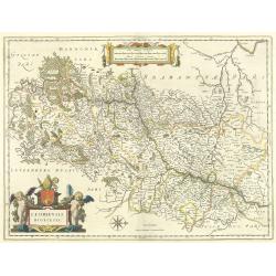
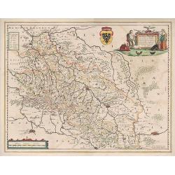
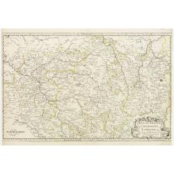
Silesia inferior, ...
Decorative map of Silesia, from Ioannis Ianssonni Novus Atlas, Sive Theatrum Orbis Terrarum : In quo Tabulae & Descriptiones omnium Regionum totius Universi accuratis...
Date: Amsterdam, 1647
Selling price: ????
Please login to see price!
Sold in 2012
Novissima Russiae Tabula.
Decorative map of Russia, from Ioannis Ianssonni Novus Atlas, Sive Theatrum Orbis Terrarum : In quo Tabulae & Descriptiones omnium Regionum totius Universi accuratiss...
Date: Amsterdam, 1647
Selling price: ????
Please login to see price!
Sold in 2012
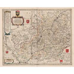
Silesiae Ducatus ...
Decorative map of Silesia, from Ioannis Ianssonni Novus Atlas, Sive Theatrum Orbis Terrarum : In quo Tabulae & Descriptiones omnium Regionum totius Universi accuratis...
Date: Amsterdam, 1647
Selling price: ????
Please login to see price!
Sold in 2012
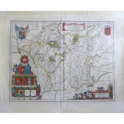
Flandria Gallica Continens Castellanias Insulensem Duacensem Orchianensem Civitatem Dominiumq: Tornacense.
This map of a part of Walloon province of Belgium in the centre is Lille, In 1667, Louis XIV of France successfully laid siege to Lille, resulting in it becoming French i...
Date: Amsterdam, 1647
Selling price: ????
Please login to see price!
Sold in 2020
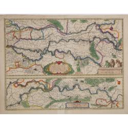
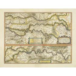
Tractus Rheni et Mosae totusq Vahalis.
Shows that part of the central Netherlands where the three great rivers flow to within but a few kilometers of each below Wesel. The scale allows most of the larger towns...
Date: Amsterdam, 1647
Selling price: ????
Please login to see price!
Sold in 2016
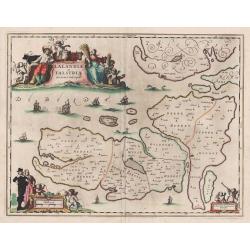
Lalandiae et Falstriae Accurata Descriptio.
Map of some regions of Denmark, from Sive Theatrum Orbis Terrarum. Text in Latin on the back.
Date: Amsterdam, 1647
Selling price: ????
Please login to see price!
Sold in 2014
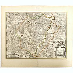
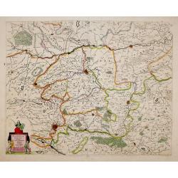
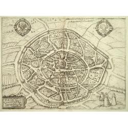
Territorium Abbatiae Herefeldensis - 't Stift Hirszfeldt.
Detailed map centered on Hirschfelt. Title cartouche embellished with two cherubs.
Date: Amsterdam, 1647
Selling price: ????
Please login to see price!
Sold in 2018
Russiae vulgo Moscovia dictae, Partes Septentrionalis..
In the north the Murmansk Sea. Including the western coast of Nova Zembla. Title cartouche and two cartouches, the bottom right one showing two hunters, bears, stags etc....
Date: Amsterdam, 1647
Selling price: ????
Please login to see price!
Sold in 2015
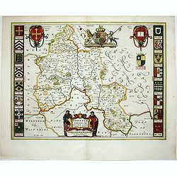
'LEICESTRENSIS COMITATUS' Leicestershire
An attractive, finely engraved and hand colored copperplate 17th century map of Leicestershire. German text edition with two Royal crests, fine cartouches for title and s...
Date: Amsterdam, 1647
Selling price: ????
Please login to see price!
Sold in 2017
Lusatia Superior.
An attractive map of the region of present-day southwestern Poland, at the border with Germany and the Czech Republic. Old city names include Prybus, Lieba, Gorlitz, Dres...
Date: Amsterdam, 1647
Selling price: ????
Please login to see price!
Sold in 2018
Hollandia Comitatus.
Orientated west to the top of the sheet, this represents the County of Holland in the classical orientation for seventeenth century maps, with Amsterdam at the centre. Th...
Date: Amsterdam, 1647
Selling price: ????
Please login to see price!
Sold in 2017
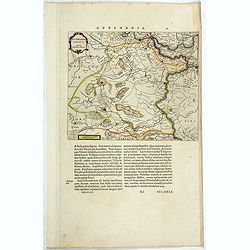
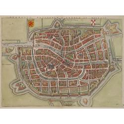
Zutphania Comitatus.
Detailed map of the area "Zutphania" includings the cities of Zutphen, Arnhem, Emmerich, and Deventer. South to the top. More about maps by Willem Blaeu. [+]
Date: Amsterdam, 1647
Selling price: ????
Please login to see price!
Sold in 2017
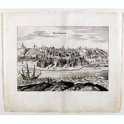
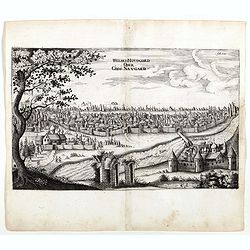
Nisen-Navgorod.
An early of Nisen-Navgorod, on the Volga river. From the rare first edition "Offt begehrte Beschreibung der newen orientalischen Rejse, so durch Gelegenheit einer H...
Date: Schleßwig, Zur Glocken, 1647
Selling price: ????
Please login to see price!
Sold

Kremelin.
An early town-view of Kremlin in Moscow. From the rare first edition "Offt begehrte Beschreibung der newen orientalischen Rejse, so durch Gelegenheit einer Holsteini...
Date: Schleßwig, Zur Glocken, 1647
Selling price: ????
Please login to see price!
Sold in 2021
Weliki: Novogord order Gros: Navgard.
An early of Veliky Novgorod in west Russia on the Volkhov River. From the rare first edition "Offt begehrte Beschreibung der newen orientalischen Rejse, so durch Ge...
Date: Schleßwig, Zur Glocken, 1647
Selling price: ????
Please login to see price!
Sold in 2017
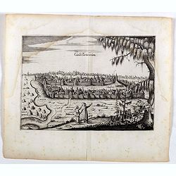
Casan Tartarorum.
An early of Kazan, Russia. From the rare first edition "Offt begehrte Beschreibung der newen orientalischen Rejse, so durch Gelegenheit einer Holsteinischen Legatio...
Date: Schleßwig, Zur Glocken, 1647
Selling price: ????
Please login to see price!
Sold in 2022
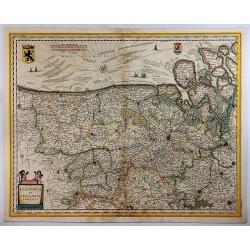
Flandria et Zeelandia Comitatus.
A decorative, large map including Flanders and Zeeland. The map was originally engraved, in 1641, for Sanderus 'Flandria Illustrata', and was used at different times in B...
Date: Amsterdam, 1647
Selling price: ????
Please login to see price!
Sold in 2018
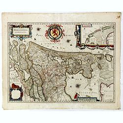
Hollandia Comitatus.
Orientated west to the top of the sheet, this represents the County of Holland in the classical orientation for seventeenth century maps, with Amsterdam at the center. Th...
Date: Amsterdam, 1647
Selling price: ????
Please login to see price!
Sold in 2019
VOLGA RIVER. -Accurata delineatio Nobilissmi toti Europae Fluminis Wolgae olim RHA dictae per Adamum Olearium.
Rare First Edition of The First Great Map of the Volga River. Nice example of Olearius' map of the Volga River, first issued in 1647 and engraved by Christian Rothgiesser...
Date: Schleswig, 1647
Selling price: ????
Please login to see price!
Sold in 2021
Estats du Czar ou Grand Duc de la Russie Blanche ou Moscovie.
Eastern portion of Sanson's two-sheet map of Russia and White Russia, extending from the Gulf of Finland to to the Caspian Sea and Central Asia. A nice example.Engraved b...
Date: Paris, 1648
Selling price: ????
Please login to see price!
Sold
Estats du Czar ou Grand Duc de la Russie Blanche ou Moscovie.
Eastern portion of Sanson's two-sheet map of Russia and White Russia, extending from the Gulf of Finland to the Caspian Sea and Central Asia. A nice example.Engraved by A...
Date: Paris, 1648
Selling price: ????
Please login to see price!
Sold
![No title: [Southern part of Italy]](/uploads/cache/11766-250x250.jpg)
No title: [Southern part of Italy]
Fine map of southern part of Italy and the northern tip of Sicily.This edition carries the date 1648, engraved by AB. De la plaets. With manuscript number in upper right ...
Date: Paris 1648
Selling price: ????
Please login to see price!
Sold
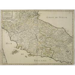
Estats de L'Eglise et de Toscane..
Fine map of Tuscany and the island of Elbe..This edition carries the date 1648. With manuscript number in upper right corner.Nicolas Sanson was to bring about the rise of...
Date: Paris, 1648
Selling price: ????
Please login to see price!
Sold in 2011
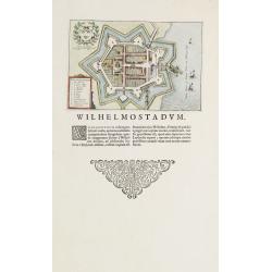
Willemstad.
Plan of the Brabant town "Willemstad" from Blaeus townbooks of the Netherlands. Latin text underneath desribing the foundation of the town by William of Orange...
Date: Amsterdam 1648
Selling price: ????
Please login to see price!
Sold
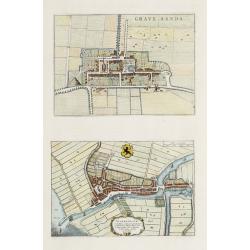
s-Gravensande, Vlaardingen.
Two plans from Blaeus townbooks of the Netherlands. Plan of the town s-Gravensande in the now-a-days province "Zuid Holland". Plan of the town Vlaardingen in...
Date: Amsterdam 1648
Selling price: ????
Please login to see price!
Sold
Lugdunum Batavorum - Leyden in Hollant
Nice hand-colored copper engraving picturing the city of Leiden. The 1648 edition of Guicciardini's famous work Description of the Netherlands was issued by J. Janssonius...
Date: Amsterdam 1648
Selling price: ????
Please login to see price!
Sold
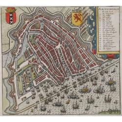
Amstelredam
Nice handcolored copper engraving picturing the city of Amsterdam. From the 1648 edition of Guicciardini's famous work Description of the Netherlands issued by J. Jansson...
Date: Amsterdam 1648
Selling price: ????
Please login to see price!
Sold
Belgicarum Provinciarum Nova Descriptio
Beautifully handcolored copper engraving picturing the Netherlands 17 Provinces. From the 1648 edition of Guicciardini's famous work Description of the Netherlands issued...
Date: Amsterdam 1648
Selling price: ????
Please login to see price!
Sold
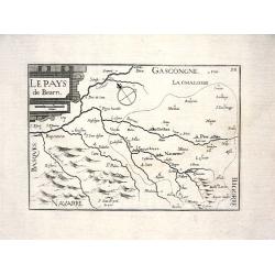
LE PAYS DE BEARN
Nice map from Tassin's desirable and scarce Atlas "Cartes generales de toutes les Provinces de France et d'Espaigne..." published by Berey in 1648. Very detail...
Date: Paris, 1648
Selling price: ????
Please login to see price!
Sold
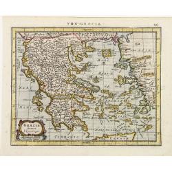
Graecia..
Detailed miniature map of Greece, from a German text edition of his Atlas Minor. The map was published in Janssonius' atlas after the cartographic sources of Laurenberg.
Date: Amsterdam (1628) 1648
Selling price: ????
Please login to see price!
Sold
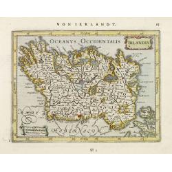
Irlandia.
Detailed miniature map of Ireland, from a German text edition of his Atlas Minor. Engraved by Petrus Kaerius.
Date: Amsterdam (1628) 1648
Selling price: ????
Please login to see price!
Sold
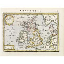
Anglia Scotia et Hibernia.
Detailed miniature map of the British Isles, from a German text edition of his Atlas Minor. Engraved by Petrus Kaerius.
Date: Amsterdam (1628) 1648
Selling price: ????
Please login to see price!
Sold

Russia cum Confiniis.
Detailed miniature map of Russia, from a German text edition of his Atlas Minor. Engraved by Petrus Kaerius.
Date: Amsterdam (1628) 1648
Selling price: ????
Please login to see price!
Sold
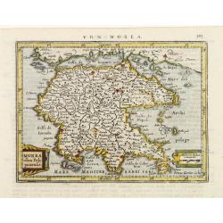
Morea olim Peloponensis.
Detailed miniature map of Morea (Pelopónnisos), from a German text edition of his Atlas Minor. Engraved by Petrus Kaerius.
Date: Amsterdam (1628) 1648
Selling price: ????
Please login to see price!
Sold
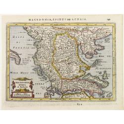
Macedonia Epirus et Achaia.
Detailed miniature map showing Macedonia Epirus and central Greece, from a German text edition of his Atlas Minor. Engraved by Petrus Kaerius.
Date: Amsterdam (1628) 1648
Selling price: ????
Please login to see price!
Sold
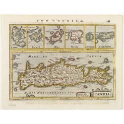
Candia.
Detailed miniature map of Crete, with 6 inset plans of other Greek islands on top. From a German text edition of his Atlas Minor. Engraved by Petrus Kaerius.
Date: Amsterdam (1628) 1648
Selling price: ????
Please login to see price!
Sold
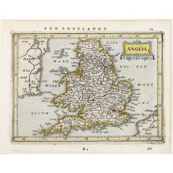
Anglia.
Detailed miniature map of England, from a German text edition of his Atlas Minor. Engraved by Petrus Kaerius.
Date: Amsterdam (1628) 1648
Selling price: ????
Please login to see price!
Sold
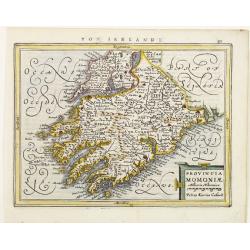
Provincia Momoniae.
Detailed miniature map of the southwestern most tip of Ireland, including the counties of Tipperary, Waterford, Limerick, Cork and Kerry. From a German text edition of hi...
Date: Amsterdam (1628) 1648
Selling price: ????
Please login to see price!
Sold
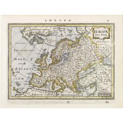
Europae Nova Tabula.
Detailed miniature map of Europe, from a German text edition of his Atlas Minor. Engraved by A. Goos.
Date: Amsterdam (1628) 1648
Selling price: ????
Please login to see price!
Sold
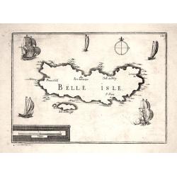
BELLE ISLE
Nice map from Tassin's desirable and scarce Atlas "Cartes generales de toutes les Provinces de France et d'Espaigne..." published by Berey in 1648. Nicely engra...
Date: Paris, 1648
Selling price: ????
Please login to see price!
Sold
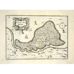
ISLE DE BOUIN
Nice map from Tassin's desirable and scarce Atlas "Cartes generales de toutes les Provinces de France et d'Espaigne..." published by Berey in 1648. Very detaile...
Date: Paris, 1648
Selling price: ????
Please login to see price!
Sold
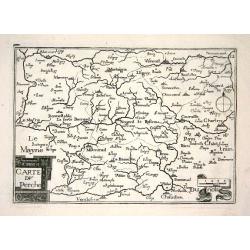
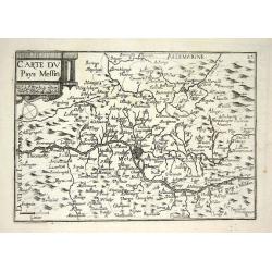
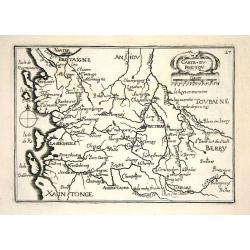
CARTE DU PERCHE
Nice map from Tassin's desirable and scarce Atlas "Cartes generales de toutes les Provinces de France et d'Espaigne..." published by Berey in 1648. Very detaile...
Date: Paris, 1648
Selling price: ????
Please login to see price!
Sold
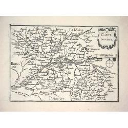
CARTE D'ANIOU
Nice map from Tassin's desirable and scarce Atlas "Cartes generales de toutes les Provinces de France et d'Espaigne..." published by Berey in 1648. Very detaile...
Date: Paris, 1648
Selling price: ????
Please login to see price!
Sold
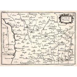
CARTE DE BEAUSSE
Nice map from Tassin's desirable and scarce Atlas "Cartes generales de toutes les Provinces de France et d'Espaigne..." published by Berey in 1648. Very detaile...
Date: Paris, 1648
Selling price: ????
Please login to see price!
Sold
CARTE DU BLAISOIS
Nice map from Tassin's desirable and scarce Atlas "Cartes generales de toutes les Provinces de France et d'Espaigne..." published by Berey in 1648. Very detaile...
Date: Paris, 1648
Selling price: ????
Please login to see price!
Sold
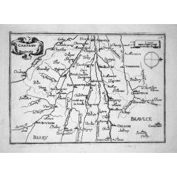
DUCHÉ D'ORLEANS
Nice map from Tassin's desirable and scarce Atlas "Cartes generales de toutes les Provinces de France et d'Espaigne..." published by Berey in 1648. Very detaile...
Date: Paris, 1648
Selling price: ????
Please login to see price!
Sold
CARTE DE L'ISLE DE FRANCE
Nice map from Tassin's desirable and scarce Atlas "Cartes generales de toutes les Provinces de France et d'Espaigne..." published by Berey in 1648. Very detaile...
Date: Paris, 1648
Selling price: ????
Please login to see price!
Sold
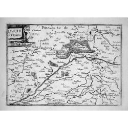
CARTE DU PAYS MESSIN
Nice map from Tassin's desirable and scarce Atlas "Cartes generales de toutes les Provinces de France et d'Espaigne..." published by Berey in 1648. Very detaile...
Date: Paris, 1648
Selling price: ????
Please login to see price!
Sold
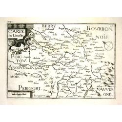
CARTE DU POICTOU
Nice map from Tassin's desirable and scarce Atlas "Cartes generales de toutes les Provinces de France et d'Espaigne..." published by Berey in 1648. Very detaile...
Date: Paris, 1648
Selling price: ????
Please login to see price!
Sold
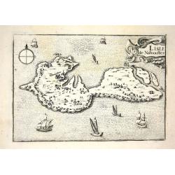
L ISLE DE NARMOUSTIER
Nice map from Tassin's desirable and scarce Atlas "Cartes generales de toutes les Provinces de France et d'Espaigne..." published by Berey in 1648. Very detaile...
Date: Paris, 1648
Selling price: ????
Please login to see price!
Sold
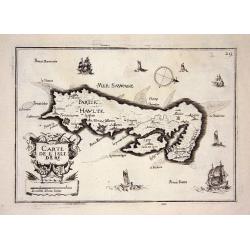
CARTE DE L'ISLE DE RE
Nice map from Tassin's desirable and scarce Atlas "Cartes generales de toutes les Provinces de France et d'Espaigne..." published by Berey in 1648. Very detaile...
Date: Paris, 1648
Selling price: ????
Please login to see price!
Sold
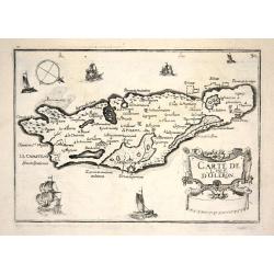
CARTE DE L'ISLE D'OLERON
Nice map from Tassin's desirable and scarce Atlas "Cartes generales de toutes les Provinces de France et d'Espaigne..." published by Berey in 1648. Very detaile...
Date: Paris, 1648
Selling price: ????
Please login to see price!
Sold
CARTE DU LIMOSIN
Nice map from Tassin's desirable and scarce Atlas "Cartes generales de toutes les Provinces de France et d'Espaigne..." published by Berey in 1648. Very detaile...
Date: Paris, 1648
Selling price: ????
Please login to see price!
Sold
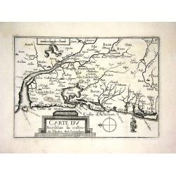
CARTE DU BOURDELOIS & COSTES DE MEDOC &D ARCACHON
Nice map from Tassin's desirable and scarce Atlas "Cartes generales de toutes les Provinces de France et d'Espaigne..." published by Berey in 1648. Very detail...
Date: Paris, 1648
Selling price: ????
Please login to see price!
Sold
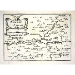
DIOCESE DE SARLAT
Nice map from Tassin's desirable and scarce Atlas "Cartes generales de toutes les Provinces de France et d'Espaigne..." published by Berey in 1648. Very detail...
Date: Paris, 1648
Selling price: ????
Please login to see price!
Sold
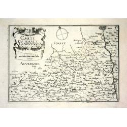
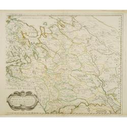
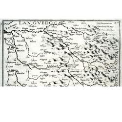
CARTE DU HAULT LANGUEDOC
Nice map from Tassin's desirable and scarce Atlas "Cartes generales de toutes les Provinces de France et d'Espaigne..." published by Berey in 1648. Very detail...
Date: Paris, 1648
Selling price: ????
Please login to see price!
Sold
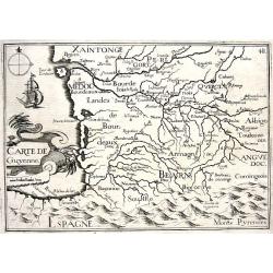
CARTE DE GUYENNE
Nice map from Tassin's desirable and scarce Atlas "Cartes generales de toutes les Provinces de France et d'Espaigne..." published by Berey in 1648. Very detail...
Date: Paris, 1648
Selling price: ????
Please login to see price!
Sold
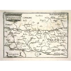
CARTE DU LIONOIS FOREST BEAUIOLOIS ET MASCONNOIS
Nice map from Tassin's desirable and scarce Atlas "Cartes generales de toutes les Provinces de France et d'Espaigne..." published by Berey in 1648. Very detail...
Date: Paris, 1648
Selling price: ????
Please login to see price!
Sold

CARTE DU BAS LAGUEDOC
Nice map from Tassin's desirable and scarce Atlas "Cartes generales de toutes les Provinces de France et d'Espaigne..." published by Berey in 1648. Very detail...
Date: Paris, 1648
Selling price: ????
Please login to see price!
Sold
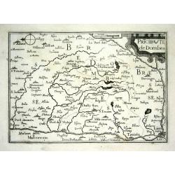
PRICIPAUTE DE DOMBES
Nice map from Tassin's desirable and scarce Atlas "Cartes generales de toutes les Provinces de France et d'Espaigne..." published by Berey in 1648. Very detail...
Date: Paris, 1648
Selling price: ????
Please login to see price!
Sold
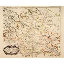
CARTE DE FOIX
Nice map from Tassin's desirable and scarce Atlas "Cartes generales de toutes les Provinces de France et d'Espaigne..." published by Berey in 1648. Very detail...
Date: Paris, 1648
Selling price: ????
Please login to see price!
Sold
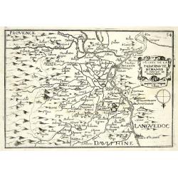
CARTE DE LA PRINCIPAUTE D'ORANGE ET CONTANT DE VENAISSIN
Nice map from Tassin's desirable and scarce Atlas "Cartes generales de toutes les Provinces de France et d'Espaigne..." published by Berey in 1648. Very detail...
Date: Paris, 1648
Selling price: ????
Please login to see price!
Sold
Lutzenbourg
This map in its earliest form by Jacob Van Deventer served as the model for Braun and Hogenberg?s 1581 map of the city. This Guicciardini map, with the engraved plate n...
Date: Amsterdam 1648
Selling price: ????
Please login to see price!
Sold
Isle de France / Champagne / Lorraine.
Showing the regions around Paris, Metz and Troyes. R. Cordier.
Date: Paris, 1648
Selling price: ????
Please login to see price!
Sold
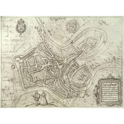
Aquisgranum, vulgo Aich Per antiqua Imperii urbs, etc.
Nice bird?s-eye view of the city of Aachen. With coats of arms of German Empire and the city. South is on top of the view. Copper etching nr. 100 in the 1648 Dutch Jansso...
Date: Amsterdam, 1648
Selling price: ????
Please login to see price!
Sold in 2008