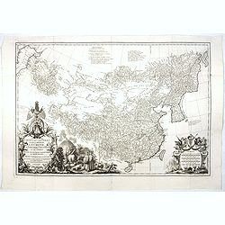
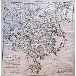
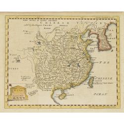
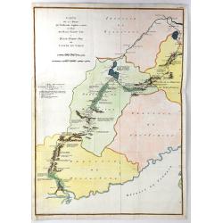
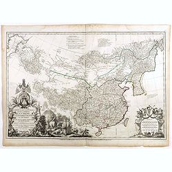
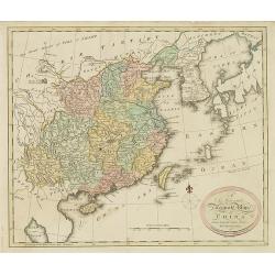
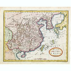
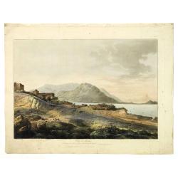
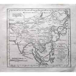
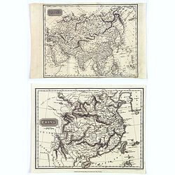
Carte la plus generale et qui comprend la Chine, la Tartarie chinoise et le Thibet. . .
With a quite elaborately pictorial cartouche, engraved by G.Kondet. Very detailed map of China, Tibet and Korea. Jean Baptiste Bourguignon d' Anville (1697-1782), French ...
Date: Paris, Ph.-D. Pierres, Clousier [- Moutard], 1785
Selling price: ????
Please login to see price!
Sold in 2017
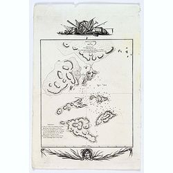
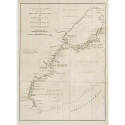
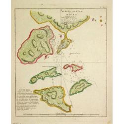
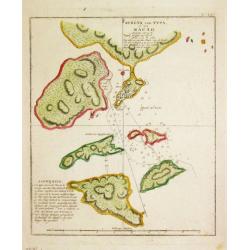
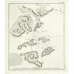
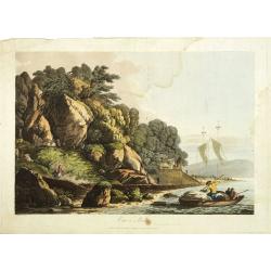
Sketch of the Typa and Macao.
A map of the environs of the Portuguese settlement of Macao in the Far East.
Date: London, 1785
Selling price: ????
Please login to see price!
Sold in 2018
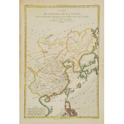
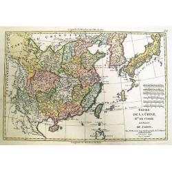
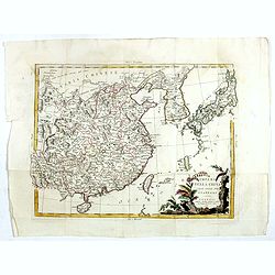
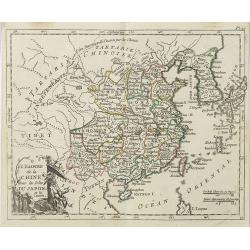
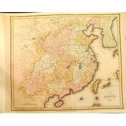
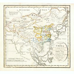
Carte de l'Empire de la Chine, de la Tartarie Chinoise, et du..
A fine map of China, Korea, Japan and Taiwan, prepared by R.Bonne and included in his Atlas Encyclopédique.. Rigobert Bonne (1727-1795) was engineer, mathematician and c...
Date: Paris 1787
Selling price: ????
Please login to see price!
Sold
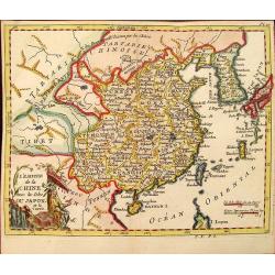
L\'Empire de la Chine avec les Isles du Japon et la Coree.
Attractive map of China and neighbouring countries from Atlas ou Collection de Cartes Geographiques pour l'Intelligence du Voyageur Francois.
Date: Paris, 1787
Selling price: ????
Please login to see price!
Sold in 2012
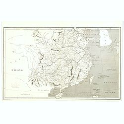
Carte de la Chine.
Uncommon French map of China and adjacent tributary states.
Date: Paris, 1787
Selling price: ????
Please login to see price!
Sold
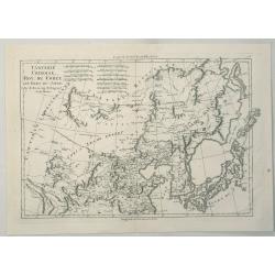
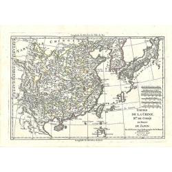
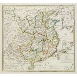
Tartarie Chinoise, Roy, Coree et Isles du Japon.
A detailed map of the region, including Japan, Korea, Manchuria and the Gobi Desert. Highly detailed. From Bonne's 'Atlas Supplement', published in 1787.Rigobert Bonne (1...
Date: Paris, 1787
Selling price: ????
Please login to see price!
Sold in 2023
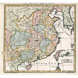
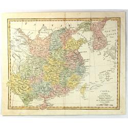
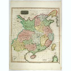
A Map of the Empire of China.
An attractive and uncommon map of China from Trusler's multi-volume work, "The Habitable World Described".
Date: London, 1788
Selling price: ????
Please login to see price!
Sold in 2018
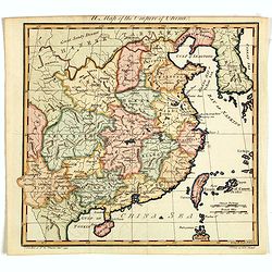
A Map of the Empire of China.
An attractive and uncommon map of China from Trusler's multi-volume work, "The Habitable World Described". In his Description of China, Trusler relied on the wr...
Date: London, 1788
Selling price: ????
Please login to see price!
Sold in 2020
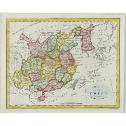
China.
Map of China, including Taiwan and Korea.
Date: London, c. 1790
Selling price: ????
Please login to see price!
Sold in 2010
Empire de la Chine, Rme. de Coree et Isles du Japon.
Rare issue by Pere Francesco Santini of a map originally by Rigobert Bonne.
Date: Venice, 1792
Selling price: ????
Please login to see price!
Sold in 2012
Empire de la Chine, Rme. de Coree et Isles du Japon.
Rare Italian issue of Rigobert Bonne's map of China, Korea, and Japan, by Pere Francesco Santini.
Date: Venice, 1792
Selling price: ????
Please login to see price!
Sold in 2017
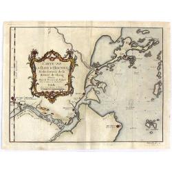
Carte de la Baye d'Hocsieu et des Entres de la Riviere de Chang Situees dans la Province de Fokyen.
Detailed regional map of China. A detailed little chart of the estuary of the Chiang River at present-day Fu-chou in the province of Fukien, adjacent to the island of Ta...
Date: Amsterdam, 1795
Selling price: ????
Please login to see price!
Sold in 2016
Carte de la Route que l'ambassade Anglais a Suive en Allant de Hang-Tchou-fou a Qhang-Tchou-Fou ou canton en Chine
A copper engraved map of a journey from Hang-Tchoo-Foo to Quang-Tchoo-Foo. Published in Stauton's "AN AUTHENTIC ACCOUNT OF AN EMBASSY FROM THE KING OF GREAT BRITAIN ...
Date: Paris, 1796
Selling price: ????
Please login to see price!
Sold in 2018
Impero delle China colle isole del Giappone. . .
A very striking map of China, Korea, Taiwan and Japan embellished with an colored pictorial title cartouche flanked by flowers and a bird. This is the uncommon edition wi...
Date: Venice, 1795-1796
Selling price: ????
Please login to see price!
Sold in 2016
Sketch of A Journey from Hang-Tchoo-Foo ...
A detailed map taken from, from Staunton's 'An Authentic Account of an Embassy from the King of Great Britain to the Emperor of China'.
Date: London, 1796
Selling price: ????
Please login to see price!
Sold in 2018
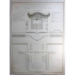
Plan of the Hall of Audience and the Adjacent Courts in the Emperor's Gardens at Yuen-min-Yuen.
A striking copper engraving from an important eighteenth century series on China by William Alexander. From Sir George Leonard Staunton's An Authentic Account of an Emba...
Date: London, 1796
Selling price: ????
Please login to see price!
Sold in 2019
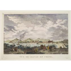
Vue de Macao en Chine.
Jean François Galoup, Comte de la Pérouse (1741-88), outstanding French explorer and hydrographer. ' Voyage autour du Monde?Atlas', 1797.An attractive view of Macao.
Date: Paris, 1797
Selling price: ????
Please login to see price!
Sold
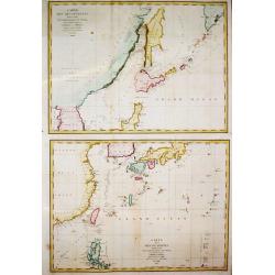
Carte des découvertes Faites en 1787 dans les Mers de Chine et de Tartarie, 1e Feuille/ 2e Feuille.
Two charts together depicting the waters of East Asia. By Jean François Galoup, Comte de la Pérouse (1741-88), outstanding French explorer and hydrographer, who publish...
Date: Paris, 1797
Selling price: ????
Please login to see price!
Sold in 2016
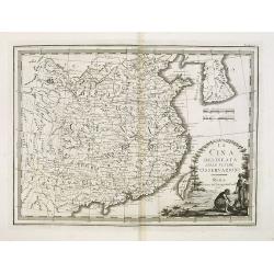
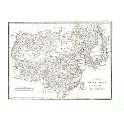
La Cina delineata sulle ultime osservazioni. Roma presso la Calcografia Cam.le, 1798.
Uncommon map of China, Taiwan and Korea, from Giovanni Maria Cassini's "Nuovo Atlante Geografico Universale delineato sulle ultime osservazioni". The Yellow Sea...
Date: Venice, 1798
Selling price: ????
Please login to see price!
Sold in 2009
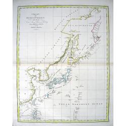
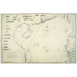
CHART OF DISCOVERIES made in 1787 in the Seas of China & Tartary between Manilla and Avatcha...
Attractive chart showing the area from Kamchatka to the Philippines, including Japan and Korea. With early geography of the islands and coasts, lined with numerous place-...
Date: London, 1798
Selling price: ????
Please login to see price!
Sold in 2010
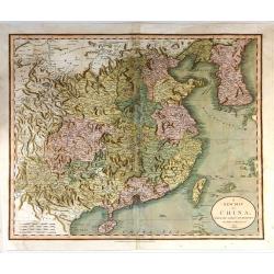
Carte la plus generale et qui comprend la Chine, la Tartarie chinoise et le Tibet. . .
With a quite elaborately pictorial cartouche, engraved by Guelard, the map was engraved by the master engraver Guillaume-Nicolas de la Haye (1727 -1802). Very detailed ma...
Date: Paris, Dezauche, 1789–1799
Selling price: ????
Please login to see price!
Sold in 2018
Reis-kaart van het Britsche gezantschap van Hang-choe-foe naar Quang-choe-foe of Kanton in China.
Uncommon map of eastern part of China, showing a journey of the English Embassy from Hangzhou (south of Shanghai) to Guangzhou (Canton). The maps is giving a wealth of in...
Date: Netherlands c.1800
Selling price: ????
Please login to see price!
Sold
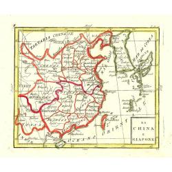
La China e Giapone.
Uncommon map of China, Korea, Japan and Taiwan (I.Formosa), only one town labelled, Tayoan. Very strange shape for Japan.
Date: Italy c. 1800
Selling price: ????
Please login to see price!
Sold
Charte von den christlichen Missionen in China, Cochinchina, Tunkin, Siam, etc.
Unusual German map of South-East Asia showing Korea, Japan, China, Taiwan, the Philippines, Borneo, Malaysia, Thailand, Vietnam, Laos, Cambodia, and Myanmar. Most of them...
Date: probably Germany around 1800
Selling price: ????
Please login to see price!
Sold in 2009
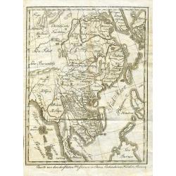
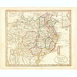
A new and Accurate map of China. . .
Map of China, including Taiwan and Korea. Engraved and published by Thomas Brown, who was active as map seller in Edinburg. Engraved by Gavin and son.From Brown's seldom ...
Date: Edinburgh, 1801
Selling price: ????
Please login to see price!
Sold in 2010
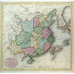
A New Map of China, From the Latest by John Cary
A beautiful example of John Cary's important 1801 map of China and Korea. Offers extraordinary detail including the great Wall of China. Also identifies the Island of Tai...
Date: London, 1801
Selling price: ????
Please login to see price!
Sold in 2015
Schets van Typa of van Macao.
Captain James Cook (1728-79), explorer, circumnavigator and hydrographer. Three voyages, 1768-71, 1772-75 and 1776-79. From 1778 on printed editions of ' Captain Cook's T...
Date: Leiden, 1795-1803
Selling price: ????
Please login to see price!
Sold
Schets van Typa of van Macao.
Captain James Cook (1728-79), explorer, circumnavigator and hydrographer. Three voyages, 1768-71, 1772-75 and 1776-79. From 1778 on printed editions of "Captain Coo...
Date: Leiden, 1795-1803
Selling price: ????
Please login to see price!
Sold in 2008
Schets van Typa of van Macao.
A map of Macao and the islands in its vicinity. From a Dutch edition of "Cook's voyages ".Captain James Cook (1728-79), explorer, circumnavigator and hydrograph...
Date: Leiden, 1795-1803
Selling price: ????
Please login to see price!
Sold in 2011
China, Contains 15 Subject Provinces Including the 2 Islands of Hainan, Formosa and the Tributary Kingdoms of Corea, Tonkin
An antique hand colored map from Wilkinson's "A General Atlas, being a Collection of Maps of the World and Quarters the Principal Empires, Kingdoms &c. with thei...
Date: London, 1803
Selling price: ????
Please login to see price!
Sold in 2016
Charte von China..
Uncommon map of China prepared by H.F.A.Stieler, giving good detail of the region and extending as far as Taiwan and the Korean peninsula.With inset map of the Ryukyu Isl...
Date: Weimar 1804
Selling price: ????
Please login to see price!
Sold
Map of China.
Showing China, Taiwan and Korea, divided into provinces with the main cities marked. The map is of interest for the use of East Sea, the sea between Korea and Japan, here...
Date: London, 1804
Selling price: ????
Please login to see price!
Sold

Map of China.
Showing China, Taiwan and Korea, divided into provinces with the main cities marked. The map is of interest for the use of Sea of Corea, the sea between Korea and Japan, ...
Date: London, 1804
Map of China.
Showing China, Taiwan and Korea, divided into provinces with the main cities marked. The map is of interest for the naming of the sea between Korea and Japan, here called...
Date: London, 1804
Selling price: ????
Please login to see price!
Sold in 2014
L'Empire de la Chine avec les Isles du Japon et la Corée . . .
Map of the Chinese Empire with Japan, Taiwan (Formose I.) and Korea, from Atlas moderne portatif composé de vingt-huit cartes sur toutes les parties du globe terrestre ....
Date: Paris, Prudhomme, Levrault, Debray, 1806
Selling price: ????
Please login to see price!
Sold
![Morokoshi Meisho Zue [Illustrated Description of Famous Sites of China].](/uploads/cache/00003-250x250.jpg)
Morokoshi Meisho Zue [Illustrated Description of Famous Sites of China].
Very rare first edition, of the famous places of Qing dynasty in China, edited and illustrated by the Japanese artists Okada Gyokuzan (1737–1812), Oka Yugaku (1762–18...
Date: Osaka, Kawachiya Kichibei, Bunka, year of the tiger, 1806
Selling price: ????
Please login to see price!
Sold in 2011
![Morokoshi Meisho Zue [Illustrated Description of Famous Sites of China].](/uploads/cache/93014-250x250.jpg)
Morokoshi Meisho Zue [Illustrated Description of Famous Sites of China].
Published : Osaka, Kawachiya Genhichiro, et al.[8 book sellers], slightly later issue but apparently in Edo period, using all the same woodblocks of original first editi...
Date: Osaka, Bunka 3 or1806
Selling price: ????
Please login to see price!
Sold in 2013
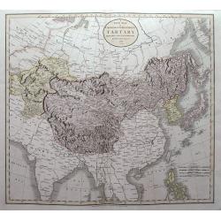
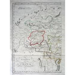
A New Map of Chinese Independent Tartary, from the Latest Authorities.
Map that displays Independent and Chinese Tartary, with present-day China, Tibet, Mongolia, Japan, South Korea, Taiwan, Kazakhstan, Uzbekistan, Turkmenistan, Iran,... Hig...
Date: London, 1806
Selling price: ????
Please login to see price!
Sold in 2015
China.
Map of China with Formosa and Strait of Corea. Topographical detail is limited to rivers, lakes, mountains and place names. Sea area shaded. Aaron Arrowsmith, (born July ...
Date: London, 1807
Selling price: ????
Please login to see price!
Sold in 2017
View in Macao, including the residence of camoens, when he wrote his Lusiad.
One of two views of Macao, taken from "Views in the South Seas" being a very important and early views depicting scenes encountered while employed as draughtsma...
Date: London, Boydell and Co., 1808
Selling price: ????
Please login to see price!
Sold in 2010
View in Macao.
Early view of Macao, taken from "Views in the South Seas" being a very important and early views depicting scenes encountered while employed as draughtsman on C...
Date: London, Boydell and Co., 1808
Selling price: ????
Please login to see price!
Sold in 2012
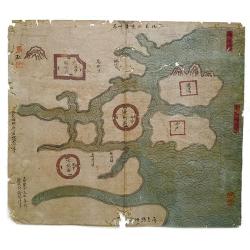
Haizhou Prefecture, Jiangsu Province.
A very rare Qing era manuscript map of Haizhou Prefecture in Jiangsu province, China showing coastal area, islands and ocean. Dated as made in 1810 by Yu Dengda from Haiz...
Date: Haizhou, 1810
Selling price: ????
Please login to see price!
Sold in 2019
The Empire of China Divided into Separate Provinces from the Latest and Best Authorities.
Uncommon map of China and Korea.
Date: Edinburgh, 1811
Selling price: ????
Please login to see price!
Sold in 2012
Charte von China...
Unusual map of east Asia, from India to Japan, including parts of Russia, and Indonesia. With several notes in German. A very interesting and rare map!
Date: Prague, 1812
Selling price: ????
Please login to see price!
Sold in 2014
Charte von China und den angränzenden Ländern und Völkerschaften so wie den letzten Kaiser Tschien-Long. . .
Uncommon map of China on a scale of ca. 1:6,000,000. The map's complete title is “Charte von China und den angränzenden Ländern, und Völkerschaften so wie sie dem le...
Date: Prague, 1812
Selling price: ????
Please login to see price!
Sold in 2015

Charte von China und den angränzenden Ländern und Völkerschaften so wie den letzten Kaiser Tschien-Long. . .
Uncommon map of China on a scale of ca. 1:6,000,000. The map's complete title is “Charte von China und den angränzenden Ländern, und Völkerschaften so wie sie dem le...
Date: Parague, 1812
Selling price: ????
Please login to see price!
Sold in 2023
Kaiserthum China.
A fascinating and unusual copper-engraved map of the Aral lake to Hainan Island shows parts of today's China, Russia, Mongolia, India, Nepal, Bhutan, Bangladesh, and Myan...
Date: Vienna, 1813
Selling price: ????
Please login to see price!
Sold in 2010
China.
Highly detailed map of China including Formosa (Taiwan), Hainan, and part of Luzon in the Philippines. The map show the Tract of the Hindoostan and Lion with the British ...
Date: Edinburgh, 1815
Selling price: ????
Please login to see price!
Sold in 2016
China / Asia.
A pair of maps from the atlas the 'Universal Geography' by Thos. Kelly, and engraved by Finlay. These copper plate maps shows the mainland of China, together with the isl...
Date: London, ca. 1817
Selling price: ????
Please login to see price!
Sold in 2017
L\'Impero della China e l\'impero del Giappone.
Scarce regional map of China, Korea and Japan.Map from the most important Florentine atlas. Bartolomeo Borghi (1750-1821) as “one of the greatest geographers of Europe....
Date: Florence, 1818
Selling price: ????
Please login to see price!
Sold in 2013
China from the best Authorities.
China from Guthrie's Geography. Engraved by John Russell.
Date: London, 1818
Selling price: ????
Please login to see price!
Sold
China, Divided into Its Great Provinces According to the Best Authorities.
The third and final edition of Carey's map of China. One of the most striking differences between maps in this edition vs previous ones is the addition of hatching along ...
Date: Philadelphia, 1818
Selling price: ????
Please login to see price!
Sold in 2020
China Sea. sheet 1.
James Horsburgh early of the coast of China, including Hong Kong, Hainan, Strait of Formosa with lower half of Formosa (Taiwan), Northern part of the Philippines.The cha...
Date: London, 1823
Selling price: ????
Please login to see price!
Sold in 2011
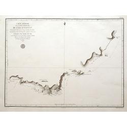
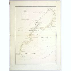
Carte réduite de la partie méridionale de l'Île d'Hainan parcourue en 1817...
A scarce sea-chart of a portion of southern Hainan, locating Sanya, Yalong Bay, Lingshui Bay, and a few more places, in the South China Sea. With the tracks of the ships,...
Date: Paris, ca. 1825
Selling price: ????
Please login to see price!
Sold in 2016
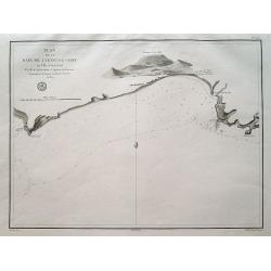
Plan de la Baie de Lyeoung-Soy en l'Île d'Hainan...
A scarce sea-chart from the explorations of Achille de Kergariou in 1817, showing a part of southern Hainan (Lingshui Bay?). With the tracks of the ships, small rocks and...
Date: Paris, ca. 1825
Selling price: ????
Please login to see price!
Sold in 2016
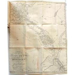
Reise nach China durch die Mongoley in den Jahren 1820 und 1821.
Rare account with the important large map "Charte der Reise von Kiachta nach Peking durch die Mongoley" (55 x 43,5 cm) and a plan of Peking (31x28cm). Extra shi...
Date: Vienna, 1826
Selling price: ????
Please login to see price!
Sold in 2016
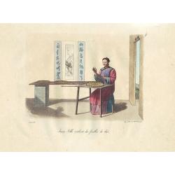
Jeune Fille roulant des feuilles de thé.
Nice hand colored engraving depicting Chinese life.From La Chine, mœurs, usages, costumes, arts et métiers, peines civiles et militaires, cérémonies religieuses, monu...
Date: Paris, 1825-1827
Selling price: ????
Please login to see price!
Sold in 2011

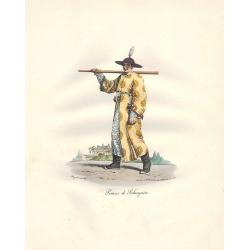
Femme de Mandarin.
Nice hand colored engraving depicting Chinese life.From La Chine, mœurs, usages, costumes, arts et métiers, peines civiles et militaires, cérémonies religieuses, monu...
Date: Paris, 1825-1827
Selling price: ????
Please login to see price!
Sold in 2011
Porteur de Palanquin.
Nice hand colored engraving depicting Chinese life.From La Chine, mœurs, usages, costumes, arts et métiers, peines civiles et militaires, cérémonies religieuses, monu...
Date: Paris, 1825-1827
Selling price: ????
Please login to see price!
Sold in 2012
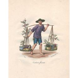
Jardinier fleuriste.
Nice hand colored engraving depicting Chinese life.From La Chine, mœurs, usages, costumes, arts et métiers, peines civiles et militaires, cérémonies religieuses, monu...
Date: Paris, 1825-1827
Selling price: ????
Please login to see price!
Sold in 2012
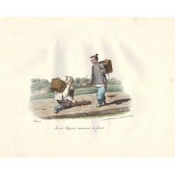
Jeunes Paysans ramassant du fumier.
Nice hand colored engraving depicting Chinese life.From La Chine, mœurs, usages, costumes, arts et métiers, peines civiles et militaires, cérémonies religieuses, monu...
Date: Paris, 1825-1827
Selling price: ????
Please login to see price!
Sold in 2011
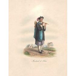
Marchand de Flûtes.
Nice hand colored engraving depicting Chinese life.From La Chine, mœurs, usages, costumes, arts et métiers, peines civiles et militaires, cérémonies religieuses, monu...
Date: Paris, 1825-1827
Selling price: ????
Please login to see price!
Sold in 2012
Marchand de Bétel.
Nice hand colored engraving depicting Chinese life.From La Chine, mœurs, usages, costumes, arts et métiers, peines civiles et militaires, cérémonies religieuses, monu...
Date: Paris, 1825-1827
Selling price: ????
Please login to see price!
Sold in 2012
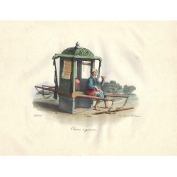
Chaise à porteurs.
Nice hand colored engraving depicting Chinese life.From La Chine, mœurs, usages, costumes, arts et métiers, peines civiles et militaires, cérémonies religieuses, monu...
Date: Paris, 1825-1827
Selling price: ????
Please login to see price!
Sold in 2011
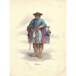
Colporteur.
Nice hand colored engraving depicting Chinese life.From La Chine, mœurs, usages, costumes, arts et métiers, peines civiles et militaires, cérémonies religieuses, monu...
Date: Paris, 1825-1827
Selling price: ????
Please login to see price!
Sold in 2012
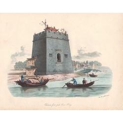
Château-fort près Tien-Sing.
Nice hand colored engraving depicting Chinese life.From La Chine, mœurs, usages, costumes, arts et métiers, peines civiles et militaires, cérémonies religieuses, monu...
Date: Paris, 1825-1827
Selling price: ????
Please login to see price!
Sold in 2011
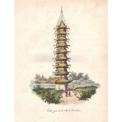
Taa, près de la ville de Sou-tcheou.
Nice hand colored engraving depicting Chinese life.From La Chine, mœurs, usages, costumes, arts et métiers, peines civiles et militaires, cérémonies religieuses, monu...
Date: Paris, 1825-1827
Selling price: ????
Please login to see price!
Sold in 2012
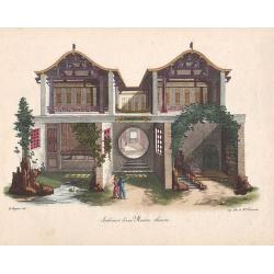
Intérieur d'une Maison chinoise.
Nice hand colored engraving depicting Chinese life.From La Chine, mœurs, usages, costumes, arts et métiers, peines civiles et militaires, cérémonies religieuses, monu...
Date: Paris, 1825-1827
Selling price: ????
Please login to see price!
Sold in 2011
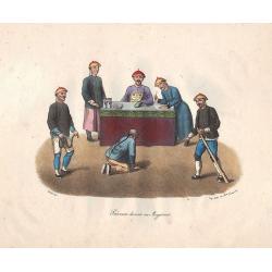
Prévenu devant un Magistrat.
Nice hand colored engraving depicting Chinese life.From La Chine, mœurs, usages, costumes, arts et métiers, peines civiles et militaires, cérémonies religieuses, monu...
Date: Paris, 1825-1827
Selling price: ????
Please login to see price!
Sold in 2011
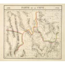
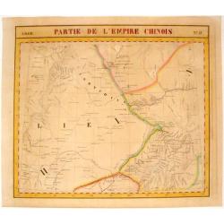
Partie de la Chine N°85. (Covers northeastern India, northern Burma and parts of Tibet, Sichuan and Yunnan.)
Covers northeastern India, northern Burma and parts of Tibet, Sichuan and Yunnan.From his famous Atlas Universel . This atlas was one of the most remarkable world atlases...
Date: Brussels, 1825-1827
Selling price: ????
Please login to see price!
Sold
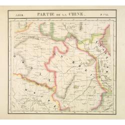
Partie de la Chine N°73. (Covers parts of Hubei, Henan, Anhui, Jiangsu, Shanxi and Shandong provinces.)
Covers parts of Hubei, Henan, Anhui, Jiangsu, Shanxi and Shandong provinces.From his famous Atlas Universel . This atlas was one of the most remarkable world atlases ever...
Date: Brussels, 1825-1827
Selling price: ????
Please login to see price!
Sold
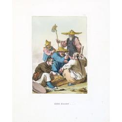
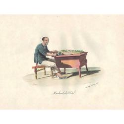
Giuocatori. (Chinese gamblers)
Aquatint with original coloring by Gaetano Zancon, taken from Giulio Ferrario's work Le Costume ancien et moderne ou histoire du gouvernement, de la milice, de la religio...
Date: Milan, 1827
Selling price: ????
Please login to see price!
Sold in 2013
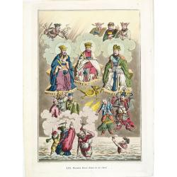
Divinita Cinesi divise in tre classi (shows the Chinese Gods. Confucius, Lanzu, Fe.)
Aquatint with original coloring by Gaetano Zancon, taken from Giulio Ferrario's work Le Costume ancien et moderne ou histoire du gouvernement, de la milice, de la religio...
Date: Milan, 1827
Selling price: ????
Please login to see price!
Sold in 2013
Partie de L'Empire Chinois .
Vandermaelen Philippe (1795 – 1869) was an eminent Belgian geographer and cartographer , famous for having designed a universal authority made Atlas and for having foun...
Date: Brussels, 1827
Selling price: ????
Please login to see price!
Sold in 2015
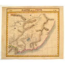
Partie de la Chine - No. 48
A detailed map delineating the border between China and Russia. Lithographed by Henri Ode. One of 387 maps of the world produced on the same scale. This map was important...
Date: Brussels, 1827
Selling price: ????
Please login to see price!
Sold in 2016
![[ XXXVIII. Ceremonie funebri].](/uploads/cache/35000-250x250.jpg)
[ XXXVIII. Ceremonie funebri].
Aquatint depicting a Chinese funeral ceremony engraved by A. Rancati. Plate N°38.From Giulio Ferrario's work Le Costume Ancien et Moderne ou Histoire du gouvernement, de...
Date: Milan, 1827
Selling price: ????
Please login to see price!
Sold in 2018
![[ LVIII. Arco di Cantone, di Ce-Ceu-Fu].](/uploads/cache/35001-250x250.jpg)
[ LVIII. Arco di Cantone, di Ce-Ceu-Fu].
Aquatint depicting an arch in Canton and Ce-Ceu-Fu, engraved by L Rossi. Plate N°58.From Giulio Ferrario's work Le Costume Ancien et Moderne ou Histoire du gouvernement,...
Date: Milan, 1827
Selling price: ????
Please login to see price!
Sold in 2018
![[XI. Ritratti d'Imperatori e d'uomini celebri].](/uploads/cache/35003-250x250.jpg)
[XI. Ritratti d'Imperatori e d'uomini celebri].
Aquatint depicting portraits of Chinese emperors and famous men, engraved by Zanconi. Plate N°11.From Giulio Ferrario's work Le Costume Ancien et Moderne ou Histoire du ...
Date: Milan, 1827
Selling price: ????
Please login to see price!
Sold in 2017
![[LXX. Donne della provincia di Kiang-Nan, e piedi delle donne Cinesi].](/uploads/cache/35006-250x250.jpg)
[LXX. Donne della provincia di Kiang-Nan, e piedi delle donne Cinesi].
Aquatint depicting women of the province of Kiang-Nan, and the shoes and feet of Chinese women, engraved by L Bigatti. Plate N°70.From Giulio Ferrario's work Le Costume ...
Date: Milan, 1827
Selling price: ????
Please login to see price!
Sold in 2018
![[XXXVI. Cappelletta di campagna].](/uploads/cache/35007-250x250.jpg)
[XXXVI. Cappelletta di campagna].
Aquatint depicting a chapel of at the Chinese country side, engraved by A. Rancati. Plate N°36.From Giulio Ferrario's work Le Costume Ancien et Moderne ou Histoire du go...
Date: Milan, 1827
Selling price: ????
Please login to see price!
Sold in 2018
