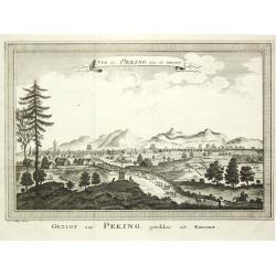
Vue de Peking, tirée de Nieuhof.
A view of Peking.
Date: Amsterdam, c. 1760
Selling price: ????
Please login to see price!
Sold
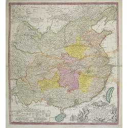
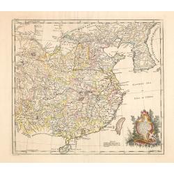
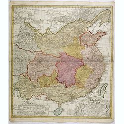
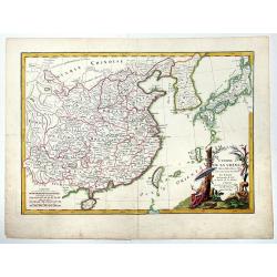
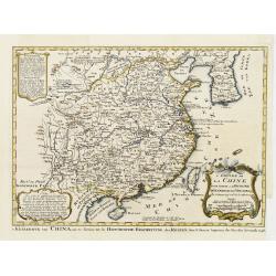
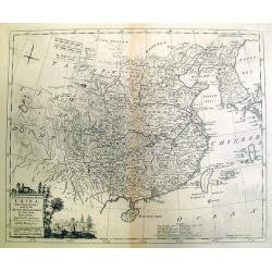
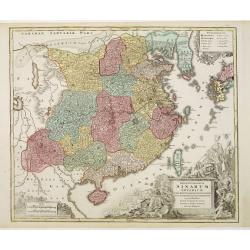
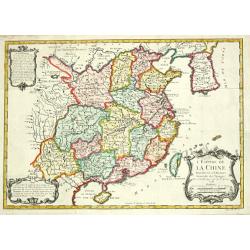
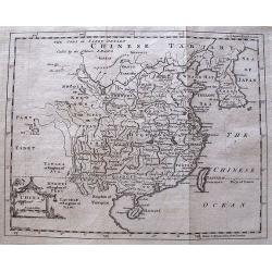
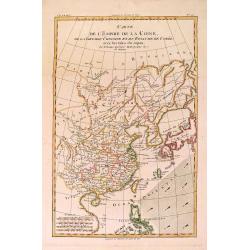
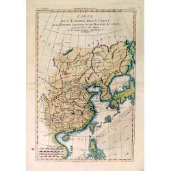
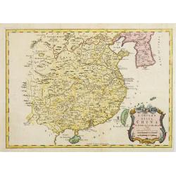
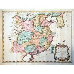
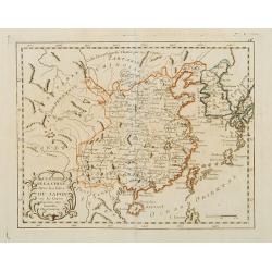
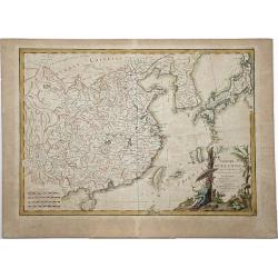
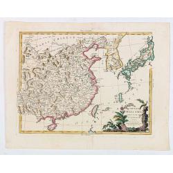
Regni Sinae vel Sinae propriae..
General map of China, including the islands of Taiwan and Hainan. The map is based on the work of du Halde. An appealing title cartouche bottom right with allegorical ima...
Date: Nuremberg, 1760
Selling price: ????
Please login to see price!
Sold in 2011
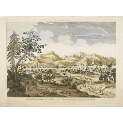
Vue de Peking Capitale de la Chine, et de la Superbe Muraille qui la Separe de la Tartarie.
So-called optical print showing panoramic view of Beijing with the Great Wall in the background.In the eighteenth and nineteenth centuries there were many popular special...
Date: Paris, 1760
Selling price: ????
Please login to see price!
Sold
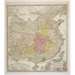
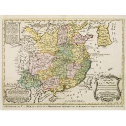
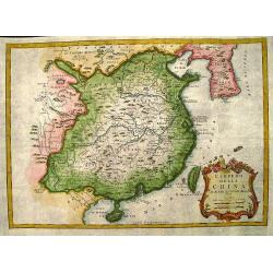
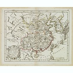
Regni Sinae vel Sinae propriae..
General map of China, including the islands of Taiwan and Hainan. The map is based on the work of du Halde. An appealing title cartouche bottom right with allegorical ima...
Date: Nuremberg, 1760
Selling price: ????
Please login to see price!
Sold in 2011
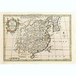
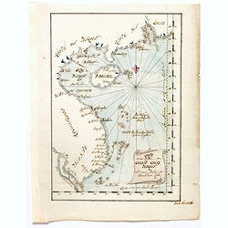
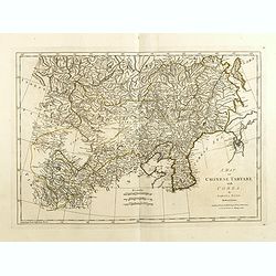
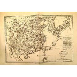
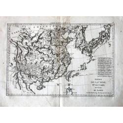
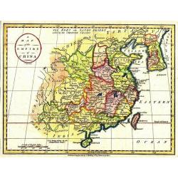
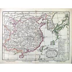
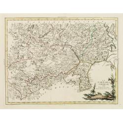
China as surveyed by the Jesuit Misionaries between the years 1708 & 1717 with Korea & the adjoining parts of Tartary.
The map is of interest for the use of Eastern Sea or Sea of China, the sea south of Korea. In the sea along the coast line of Korea : "Kau-Li-Qua or King:m of Korea&...
Date: London, c. 1760
Selling price: ????
Please login to see price!
Sold in 2014
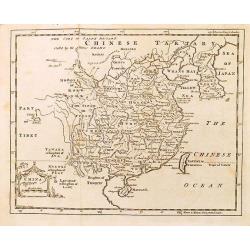
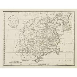
A New & Accurate Map of the Empire of China, from the Sieur Robert's Atlas, with Improvements.
Nice example of Bowen's map of China with neighboring Korea and Formosa published for the 'Geographical Dictionary' in London around 1760. Excellent detail, decorative ca...
Date: London, 1760
Selling price: ????
Please login to see price!
Sold in 2015
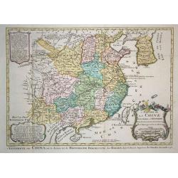
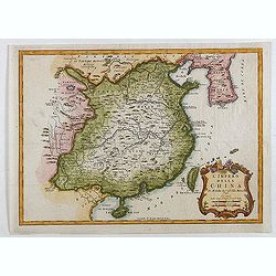
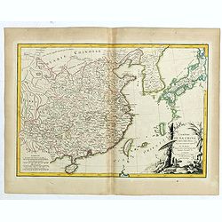
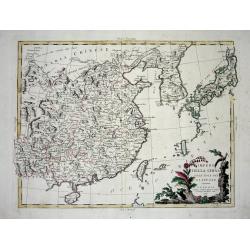
Regni Sinae vel Sinae propriae..
General map of China, including the islands of Taiwan and Hainan. The map is based on the work of du Halde. An appealing title cartouche bottom right with allegorical ima...
Date: Nuremberg, 1760
Selling price: ????
Please login to see price!
Sold in 2015
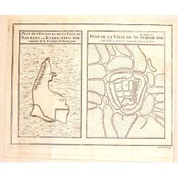
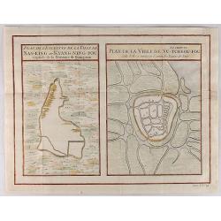
Plan de la Ville de Su-Tcheou-Fou / Plan de L'Enceinte de la Ville de Nan-King.
Two plans on one page. One is a plan of Nanking while the other is of the town of Su-Chew-Fu. Published in Paris by Jacques Nicolas Bellin in 1760.
Date: Paris, 1760
Selling price: ????
Please login to see price!
Sold in 2016
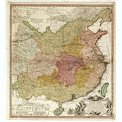
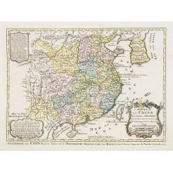
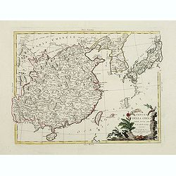
Regni Sinae vel Sinae propriae. . .
General map of China extending to the Gobi Desert in the North, including the islands of Taiwan and Hainan. The map is based on the work of du Halde. An appealing title c...
Date: Nuremberg, 1760
Selling price: ????
Please login to see price!
Sold
Karte von den Küsten von Cochin China, Tunquin und einem Theile der chinesischen Küste
Manuscript map of the coast of Northern Vietnam up to coast of the south Chinese coast below there the island of Hainan. In upper right corner the region of Canton, Macao...
Date: Germany, ca. 1760
Selling price: ????
Please login to see price!
Sold in 2020
Plan de l'Enceinte de la Ville de Nan-King ou Kyang-Ning-Fou (and) Plan de la Ville de Su-Tcheou-Fou.
Two maps on a single sheet, depicting major Chinese Cities. The plan of the left shows Nanking and its fortifications. The plan on the right shows Su-Tcheou-Fou or Su-Che...
Date: Paris, 1760
Selling price: ????
Please login to see price!
Sold in 2018
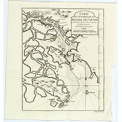
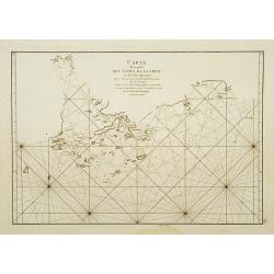
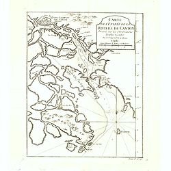
Carte de l'entrée de la Riviere de Canton. . .
Bellin's map of the mouth of the Canton River, from the island of Macao, to Canton itself. Shows the future site of Hong Kong (Sinn-gan-hein).The city of Canton is divide...
Date: Paris, 1760
Selling price: ????
Please login to see price!
Sold in 2020
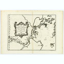
Carte de la Baye d'Hocsieu. . .
An interesting map showing the mouth and estuary of the Chiang River in southwest China, opposite Taiwan (Formosa) by Prevost, after Bellin. It shows the modern day Chine...
Date: Paris, ca 1760
Selling price: ????
Please login to see price!
Sold in 2020
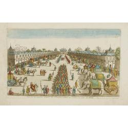
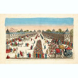
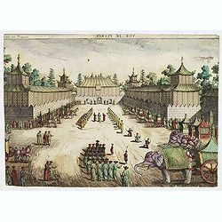
Vue de la superbe Entrée de l'Embassadeur de Siam a la Cour de Pekin.
So-called optical print illustrating a pompous parade to celebrate the arrival of the ambassador of Siam in Beijing.Mondhare was a well-known publisher of optical prints,...
Date: Paris, 1761
Selling price: ????
Please login to see price!
Sold in 2010
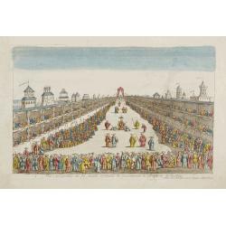
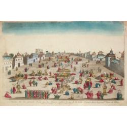
Vue perspective de la grande Ceremonie du Couronnement de l'Empereur de la Chine.
So-called optical print illustrating the crowning of the Chinese emperor. It shows the throne at the center.Mondhare was a well-known publisher of optical prints, establi...
Date: Paris, 1761
Selling price: ????
Please login to see price!
Sold
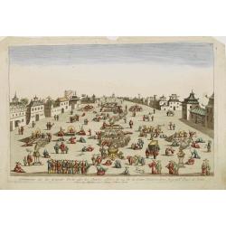
Ceremonie de la grande Feste que les Chinois celebre le 24 de la Lune d'Aoust..
So-called optical print illustrating great festivities on the 24th of August in Beijing.Mondhare was a well-known publisher of optical prints, established in Paris, at ru...
Date: Paris, 1761
Selling price: ????
Please login to see price!
Sold
Vue de la superbe Entrée de l'Embassadeur de Siam a la Cour de Pekin.
So-called optical print illustrating a pompous parade to celebrate the arrival of the ambassador of Siam in Beijing.Mondhare was a well-known publisher of optical prints,...
Date: Paris, 1761
Selling price: ????
Please login to see price!
Sold
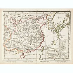
Ueberstetzung der Algemeinen Welthistorie die in England durch eine geselschaft von Gelehrten ausgefertigt worden vol. 24
Part of an extensive work on general world history, this volume focusing on Siam, CochinChina, Tartary, and China including a large fold-out map of China based on D'Anvil...
Date: Halle, 1762
Selling price: ????
Please login to see price!
Sold in 2011
L'EMPIRE DE LA CHINE d'après l'Atlas Chinois avec les Isles du Japon.
A detailed map of China, Korea and the Islands of Japan, showing the Provinces, towns, mountains, rivers, lakes, islands, published in Paris by Jean Lattre. The map is dr...
Date: Paris, 1762
Selling price: ????
Please login to see price!
Sold in 2019
L'Empire de La Chine pour servir a L'Histoire Generale des Voyages..
Detailed colored map of China and Korea in the Northeast with the Chinese Sea.The map is high accurate and naming many cities, lakes, rivers and mountains. Major towns ar...
Date: Amsterdam 1763
Selling price: ????
Please login to see price!
Sold
![Histoire universelle depuis le commmencement du monde jusqu'a present. . . Tome Vingtieme. Contenant [...] l'histoire [...] la Chine [...] la Corée [...] du Japon [...] & des [...] Indes Orientales](/uploads/cache/35153-250x250.jpg)
Histoire universelle depuis le commmencement du monde jusqu'a present. . . Tome Vingtieme. Contenant [...] l'histoire [...] la Chine [...] la Corée [...] du Japon [...] & des [...] Indes Orientales
Volume 20 of this informative publication with a description of China and Korea and the discoveries, conquests, and settlements by the Portuguese, Spaniards, English, and...
Date: Amsterdam, Leipzig, 1763
Selling price: ????
Please login to see price!
Sold in 2014
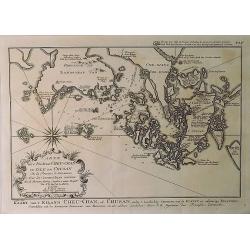
Kaart van't Eiland Cheu-chan of Chusan. . .
A detailed map of Zhoushan Island & Zhajiang China (The coastal area east of Ningbo in the Chinese province of Chekiang, located across the bay from Shanghai). The or...
Date: Paris, 1763
Selling price: ????
Please login to see price!
Sold in 2021
A New and Accurate Map of China, Drawn From Surveys Made by the Jesuit Missionaries. . .
Uncommon map by Kitchin, which appeared in "A Complete Collection of Voyages and Travels" by John Harris, printed for T. Osborne. The map closely resembles Thom...
Date: London, 1764
Selling price: ????
Please login to see price!
Sold in 2012
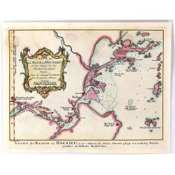
Carte de la Baye d'Hocsieu et des Entrees de la Riviere de Chang Situes dans la Province de Fokyen...
A striking antique map of the mouth of the Yangtze River China by the French cartographer, Nicolas Bellin. Published in Antoine-François Prevost's “ L`Histoire General...
Date: Paris, 1764
Selling price: ????
Please login to see price!
Sold in 2019
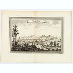
Vue de Peking tiree de Nieuhof.
This handsome view shows Beijing from the countryside, showing the city rising above its massive ancient walls. When Nieuhof visited Peking in the 1650s, the city was the...
Date: Paris, 1764
Selling price: ????
Please login to see price!
Sold in 2019
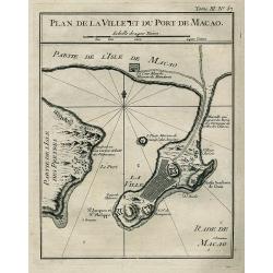
PLAN DE LA VILLE ET DU PORT DE MACAO
Bellin\'s important and interesting map of the bay and city of Macau. Macau was the first and the last European colony in China. It was under Portuguese control from the ...
Date: Paris, ca. 1765
Selling price: ????
Please login to see price!
Sold in 2008
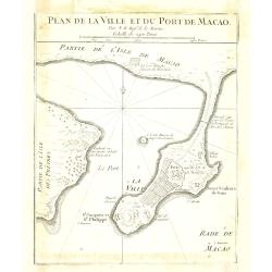
Plan de la ville et du port de Macao.
Bellin's important and interesting map of the bay and city of Macau. Macau was the first and the last European colony in China. It was under Portuguese control from the 1...
Date: Paris, ca. 1765
Selling price: ????
Please login to see price!
Sold in 2010
Grande Tartarie et Isles du Japon.
Text on both sides. Curious shape for Japan, but Ieso as an island and on the position of Hokaido.Curious shape for Korea.
Date: Paris 1766
Selling price: ????
Please login to see price!
Sold in 2009
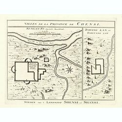
Villes de la Province de Chensi. Steden van't Landschap Shensi of Shansi.
Interesting set of two local town plans of "Si-Ngan-Fu: Capitale, Hoofdstad." and "Tchang Lan, Ou Tchouang Lan.", both cities in the province of Shanx...
Date: The Hague, Pieter de Hondt, 1747-1767
Selling price: ????
Please login to see price!
Sold in 2022
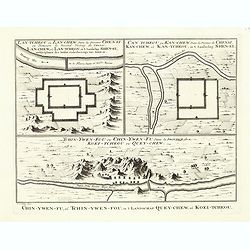
Tchin-Ywen-Fou (...). Chin-Ywen-Fu, (...), in't Landschap Quey-Chew, of Koei-Tcheou.
Interesting set of three local town plans each with extensive titles : "Lan-Tcheou ou Lan-Chew Dans la Province Chensi (…). Lan-Chew, of Lan-Tcheou, in't Landschap...
Date: The Hague, Pieter de Hondt, 1747-1767
Selling price: ????
Please login to see price!
Sold in 2022
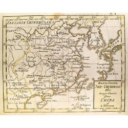
Mappa Geogr. JMP: Chinensis Eller Geogr:Charta ofwer China.
Uncommon Swedish map of China by Andrew Akerman (1721-1778), taken from his successful "Atlas Juvenilis eller Geographiska Chartor till ungdomens tienst i methodisk ...
Date: Uppsala, 1768
Selling price: ????
Please login to see price!
Sold in 2011
Empire de la Chine.
Small detailed map showing the eastern part of China as well as Korea. Including Taiwan and Hainan. Dated 1769.From Atlas Portatif Universel, by Robert de Vaugondy.Page 7...
Date: Paris, later than 1769
Selling price: ????
Please login to see price!
Sold in 2008
Empire de la Chine.
An attractive small detailed map showing the eastern part of China as well as Korea. Including Taiwan and Hainan. Dated 1769 in the cartouche.From ‘Atlas Portatif Unive...
Date: Paris, 1769
Selling price: ????
Please login to see price!
Sold in 2016
Opulentissimum Sinarum Imperium.
Detailed map of China. Korea, Taiwan and southern tip of Japan.T.C.Lotter married M.Seutter's daughter in 1740 and succeeded him in 1756. Lotter used the copperplate of S...
Date: Augsburg, 1770
Selling price: ????
Please login to see price!
Sold
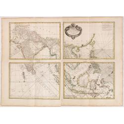
Carte Hydro-geo-graphique des Indes Orientales.. (Set of Four Maps)
A detailed map with a large, and very decorative title cartouche, showing the coast of southern China, Taiwan and the northern Philippines region with particular detail i...
Date: Paris 1771
Selling price: ????
Please login to see price!
Sold in 2014
L'Empire de la Chine avec les isles du Japon.
Uncommon map of China, Japan, Korea and Taiwan. In lower right division of Chinese provinces. In bottom 4 scales.
Date: Paris / Bordeaux, 1771
Selling price: ????
Please login to see price!
Sold in 2015
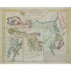
Nouvelle Représentation Des Côtes Nord Et Est De L'Asie ...
Three maps on one sheet, showing the north eastern coast line of China with Kamtschatka. From Diderot's Encyclopedie.
Date: Paris, 1772
Selling price: ????
Please login to see price!
Sold in 2011
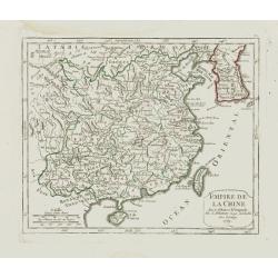
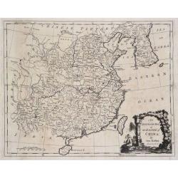
L' Empire de la Chine, 1748.
Jaques Nicolas Bellin (1702-720) was the most important French hydrographer of the 18th century. Sea-atlas 'Hydrographique Français' , 1756-65, atlas to accompany Prévo...
Date: Amsterdam, 1773
Selling price: ????
Please login to see price!
Sold
L'Empire de La Chine../ 't Keizerryk van China..
Attractive map of China with Korea and Taiwan (I.Tay-wan, ou Formosa). Decorative title cartouches in three corners.From Atlas Portatif pour servir a l'intelligence de l'...
Date: Amsterdam 1773
Selling price: ????
Please login to see price!
Sold
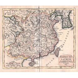
L'Empire de la Chine Pour Servir a l'Histoire des Etablissemens Europeens. Orbis terrarum
Attractive and detailed map of China and Korea, with Canton, Nanking and Taiwan. Taiwan is called Isle Tay-wan, ou de Formosa. The Sea of Japan is labeled Mer de Coree. T...
Date: Amsterdam, 1773
Selling price: ????
Please login to see price!
Sold in 2009
L'Empire de La Chine pour servir a l'histoire des etablissemens europees ..
Attractive map of China with Canton, Nanking and Taiwan, called Isle Tay-wan, ou de Formosa.The map is of interest for the use of East Sea, the sea between Korea and Japa...
Date: The Hague, 1773
Selling price: ????
Please login to see price!
Sold
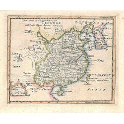
A map of Chinese Tartary with Corea.
The map is of interest for the use of Coreen Sea, the sea between Korea and Japan.Detailed map of China and Korea with Jeso Gasima in the east. Including The Gobi Desert,...
Date: London, 1774
Selling price: ????
Please login to see price!
Sold in 2015
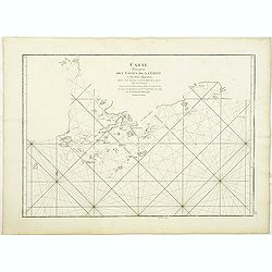
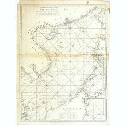
Carte d'une partie des Côtes de la Chine et des Isles adjacentes depuis l'Isle nommée la Pierre Blanche, jusqu'à celle de l'Artimon.
Most important milestone chart based upon the surveys made from navigational surveys and soundings in 1754, 1759, and 1760 by Alexander Dalrymple. This edition of Dalrymp...
Date: Paris, ca 1775
Selling price: ????
Please login to see price!
Sold
Carte d'une partie des Côtes de la Chine et des Isles adjacentes depuis l'Isle nommée la Pierre Blanche, jusqu'à celle de l'Artimon.
Most important milestone chart based upon the surveys made from navigational surveys and soundings in 1754, 1759, and 1760 by Alexander Dalrymple. This edition of Dalrymp...
Date: Paris, ca. 1775
Selling price: ????
Please login to see price!
Sold in 2010
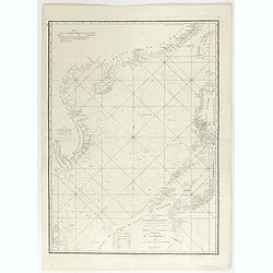
A chart of the China Sea inscribed to Monsr. D'APRES de MANNEVILLETTE .. To A.Dalrymple.
Most important milestone based upon the surveys made from navigational surveys by Alexander Dalrymple (1737-1808]. He was the first Hydrographer of the British Admiralty...
Date: Paris, ca. 1775
Selling price: ????
Please login to see price!
Sold
Carte d'une partie des Côtes de la Chine et des Isles adjacentes depuis l'Isle nommée la Pierre Blanche, jusqu'à celle de l'Artimon.
Most important milestone chart based upon the surveys made from navigational surveys and soundings in 1754, 1759, and 1760 by Alexander Dalrymple. This edition of Dalrymp...
Date: Paris, Brest, Demonville, 1775
Selling price: ????
Please login to see price!
Sold in 2012
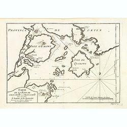
Carte de la Baye de Chin-Chew ou Chang-Chew avec les Isles d'Emowi et de Quemowi ...
A small but very early and interesting map of the coastline from Pu-tay Point, down to the Chin Chew river, with Ko-long-fu, Lakkateyn, Tano-fita, Roo Point, Womends Isle...
Date: Paris, 1738-1775
Selling price: ????
Please login to see price!
Sold in 2013
Carte de l'Entrée de la riviere de Canton Dressee sur les Observations les plus recentes.
A small but very early and interesting map of the mouth of the Canton River with the island of Macao and the future site of Hong Kong (Sinn-gan-hien). The fortified city ...
Date: Paris, 1738-1775
Selling price: ????
Please login to see price!
Sold in 2022
A chart of the China Sea inscribed to Monsr. D\'APRES de MANNEVILLETTE . . . To A.Dalrymple.
Most important milestone based upon the surveys made from navigational surveys by Alexander Dalrymple (1737-1808]. He was the first Hydrographer of the British Admiralty...
Date: Paris, ca. 1775
Selling price: ????
Please login to see price!
Sold in 2015
Vue de Peckin. (Peking)
So-called optical print of Peking published by "Collection des prospects" and engraved by G. B. Leizelt. Title is engraved mirror-imaged along the top. Lower ti...
Date: Augsburg, 1778
Selling price: ????
Please login to see price!
Sold in 2012
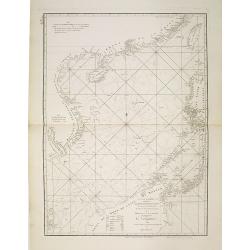
A general chart of the China Sea : drawn from the journals of the European navigators, particularly from those collected by Capt. Hayter.
A scarce and detailed showing China Sea with Taiwan, western part of the Philippines, northern part of Borneo and the coast of South China with Cochinchina. Latitude and...
Date: London, 1778
Selling price: ????
Please login to see price!
Sold in 2013
China.
Prepared by Thomas Jefferys and Thomas Phinn for Salmon's New Universal Geographical Grammar.
Date: Edinburgh, 1778
Selling price: ????
Please login to see price!
Sold in 2018
An Accurate Map of the Empire of China.
A highly detailed map of China and Korea including both Hainan and Formosa (Taiwan). An ornate scenic title cartouche completes the composition. The maps border shows the...
Date: London, 1779
Selling price: ????
Please login to see price!
Sold in 2015
Ceremonie de la grande Feste que les Chinois celebre le 24 de la Lune d'Aoust dans la principale Place de Pekin.
An optical view of festivities on the 24th of August in Bejing.
Date: Paris, c. 1780
Selling price: ????
Please login to see price!
Sold
China.
Decorative map by the noted English cartographer Thomas Jeffreys, Geographer to George III and the Prince of Wales.
Date: London, c. 1780
Selling price: ????
Please login to see price!
Sold in 2012
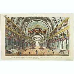
Vue d'un Temple Chinois.
So called optical print showing the interior of a Chinese temple. In the eighteenth and nineteenth centuries there were many popular specialty establishments in Paris, Au...
Date: Paris, 1780
Selling price: ????
Please login to see price!
Sold in 2017
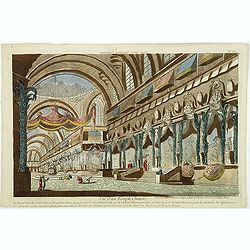
Vue du superbe Temple du Serpent dans la Ville de Juida a la Chine.
Uncommon, so-called optical print of a imaginary interior of a Chinese temple, decorated with vases and two large Buddha's in the center. In the eighteenth and nineteenth...
Date: Paris, 1780
Selling price: ????
Please login to see price!
Sold in 2017
Empire de la Chine, Rme. de Coree, ad Isles Du Japon
Attractive map of China that includes an impressive 11 different scales.
Date: Paris, c. 1780
Selling price: ????
Please login to see price!
Sold
China.
Decorative map by the noted English cartographer Thomas Jeffreys, Geographer to George III and the Prince of Wales.
Date: London, c. 1780
Selling price: ????
Please login to see price!
Sold in 2012
Carte de L'Empire de la Chine. . .
Nice copper-engraved map of China, Korea and Japan. Most of the topographical detail is limited to China. Small arrows indicate the trade winds. The map bears four distan...
Date: Paris, c. 1780
Selling price: ????
Please login to see price!
Sold in 2012
Carte de L'Empire de la Chine . . .
Nice copper-engraved map of China, Korea and Japan. Most of the topographical detail is limited to China. Small arrows indicate the trade winds. The map bears four distan...
Date: Paris, c. 1780
Selling price: ????
Please login to see price!
Sold in 2013
Empire de la Chine, Rme. de Coree, ad Isles Du Japon.
Very attractive map of China that includes 11 different scales.
Date: Paris, c. 1780
Selling price: ????
Please login to see price!
Sold in 2018
L'Empiro dela China. . .
Attractive map of China with Korea and Taiwan (I.Tay-wan, ou Formosa). Decorative title cartouches in three corners. Uncommon Italian issue. The major towns and cities sh...
Date: Venice, 1781
Selling price: ????
Please login to see price!
Sold in 2008
L'Impero Della China.
Uncommon map of China from the Italian version of Bellin's Petit Atlas Maritime.
Date: Venice, 1781
Selling price: ????
Please login to see price!
Sold in 2012
L'Impero Della China.
The map is of interest for the use of Mare di Corea, the sea between Korea and Japan.Attractive and scarce map of China with Korea, Taiwan and Hainan from "Teatro De...
Date: Venice, 1781
Selling price: ????
Please login to see price!
Sold in 2020
L'Impero della China.
A rare map of China, from 'Teatro della Guerra', the Italian version of Bellin's French 'Petit Atlas Maritime.'
Date: Venice, 1781
Selling price: ????
Please login to see price!
Sold in 2020
A Map of the Empire of China.
Map showing China, Formosa, and Korea. The map is of interest for the use of East Sea, the sea between Korea and Japan, here called "Sea of Korea". Uncommon map...
Date: London, 1782
Selling price: ????
Please login to see price!
Sold in 2011
A map of the Empire of China.
Map showing China, Formosa and Corea.The map is of interest for the use of East Sea, the sea between Korea and Japan, here called "Sea of Korea".Uncommon map en...
Date: London, 1782
Selling price: ????
Please login to see price!
Sold in 2010
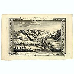
A View of the celebrated Great Wall of China which divides that Empire from Tartary...
A decorative copperplate print of festivities being held at the Great wall in China. The scene is framed within an ornately decorative border. Engraved for Millar's 'New ...
Date: London, ca. 1782
Selling price: ????
Please login to see price!
Sold in 2021
L'Empire de la Chine Avec les Isles Du Japon et la Coree ..
Rare map of China, including Korea, Taiwan and southern part of Japan, prepared after J.B.Nolin and published by Monhare for his Atlas Général a l'usage des colleges et...
Date: Paris, 1783
Selling price: ????
Please login to see price!
Sold
L'Empire de la Chine.
Attractive map of China, Korea, and Japan by Lattre.
Date: Paris, 1783
Selling price: ????
Please login to see price!
Sold in 2012
L'empire de la Chine avec les Isles du Japon. . .
Scarce map of China, including Korea, Taiwan and southern part of Japan, prepared by Nolin and published by L.J. Mondhare for his Atlas Général a l'usage des colleges e...
Date: Paris, 1783
Selling price: ????
Please login to see price!
Sold in 2017
L'Empire de la chine . . .
Attractive map of China, ornated with a decorative title cartouche. Boundaries outlined in hand colorPrepared by Le Sieur Janvier, Jean Denis [Robert], French geographer ...
Date: Paris, ca 1783
Selling price: ????
Please login to see price!
Sold in 2020
L'EMPIRE DE LA CHINE d'apres l'Atlas Chinois avec les isles du Japon.
An attractive map of eastern part of China, including Taiwan, Korea and Japan. With ornamental title cartouche. Boundaries outlined in hand color. From the 'Atlas moderne...
Date: Paris, 1783
Selling price: ????
Please login to see price!
Sold in 2021
La Tartaria Chinese.
With decorative title cartouche. Covering north eastern part of China, Korea and Hokkaido (here called Jeso-Gasima ).
Date: Venice, 1784
Selling price: ????
Please login to see price!
Sold in 2010
Impero della China colle Isole del Giappone
Large copper-engraved map by Zatta, published in the monumental "Atlante Novissimo" in Venice. Shows Japan, Korea and China with Formosa in much detail. Handsom...
Date: Venice 1784
Selling price: ????
Please login to see price!
Sold
Impero delle china colle isole del Giappone. . .
Large copper-engraved map by Zatta, published in the monumental "Atlante Novissimo" in Venice. Shows Japan, Korea and China with Formosa in much detail. Handsom...
Date: Venise, 1784
Selling price: ????
Please login to see price!
Sold in 2011
Empero Della China Giappone.
Fine map of China, Korea and Japan. Shows administrative boundaries, major cities, villages, rivers and mountains. Map from "Atlas Novissimo" printed in Venice ...
Date: Venise, 1784
Selling price: ????
Please login to see price!
Sold in 2020
Sketch of the Typa and Macao.
A map of the environs of the Portuguese settlement of Macao in the Far East. The map shows a small town plan of Macao, nearby rocks, shoals depth soundings, and a few nav...
Date: London, 1785
Selling price: ????
Please login to see price!
Sold in 2020
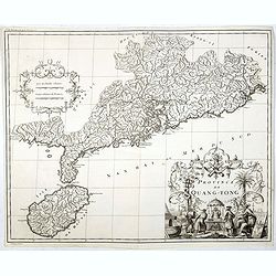
Province de Quang-Tong.
Very detailed map of Hong Kong and its surroundings.The map engraved by the master engraver Delahaye, with a quite elaborately pictorial cartouche, engraved by D. Sorniqu...
Date: Paris, Ph.-D. Pierres, Clousier [- Moutard], 1785
Selling price: ????
Please login to see price!
Sold in 2017
