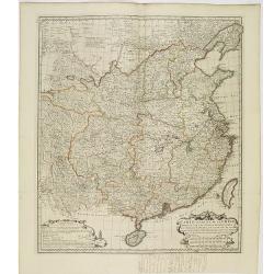
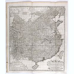
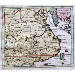
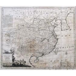
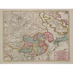
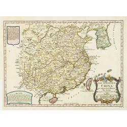
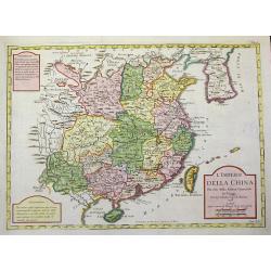
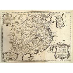
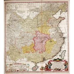
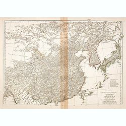
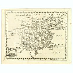
Carte Generale de la Chine Dressée sur les Cartes Particulieres Que l' Empereur Chang-Hi a fait lever sur les lieux..
Large map showing the traditional limits of China, including Hainan and Formosa in the South, and Quantong and parts of the Gobi Desert in the North.As the title notes, t...
Date: Paris , 1737
Selling price: ????
Please login to see price!
Sold in 2014
Nouvel atlas de la Chine, de la Tartarie chinoise, et du Thibet.
First edition of "the principal cartographic authority on China during the 18th century". It was the second major atlas of China produced in Europe following th...
Date: The Hague, H. Scheurleer, 1737
Selling price: ????
Please login to see price!
Sold
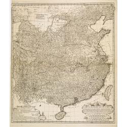
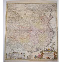
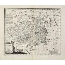
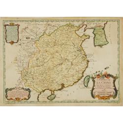
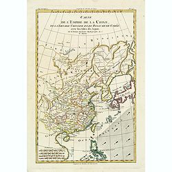
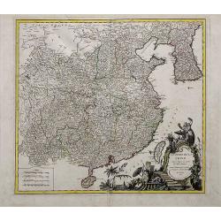
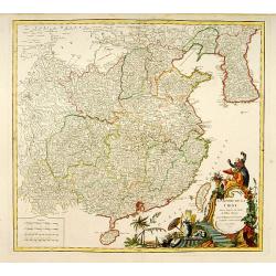
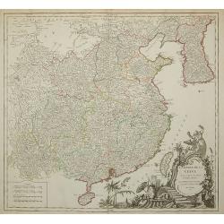
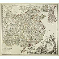
Carte générale de la Chine Dressée sur les Cartes particulières que l'Empereur Cang-hi a fait lever sur les lieux par les RR. PP. Jésuites missionaires dans cet empire / Par le Sr d'Anville.
Important and very detailed map of Southern part of China, including a detailed Taiwan. Jean Baptiste Bourguignon d' Anville (1697-1782) was a French cartographer and com...
Date: The Hague, H. Scheurleer, 1737
Selling price: ????
Please login to see price!
Sold in 2013
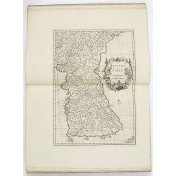
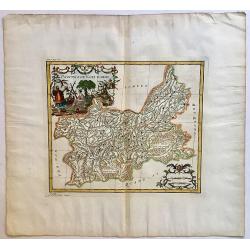
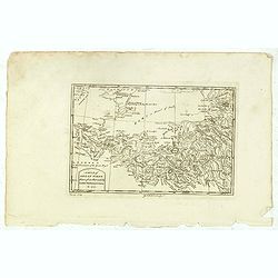
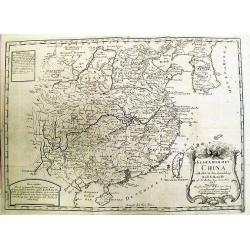
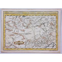
Province de Chen-Si.
With a quite elaborately pictorial cartouche, engraved by Guélard, the map by Delahaye. Jean Baptiste Bourguignon d' Anville (1697-1782), French cartographer. Compiled o...
Date: The Hague, 1737
Selling price: ????
Please login to see price!
Sold in 2014
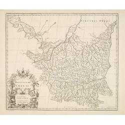
Province de Koei-Tcheou.
Appeared in d'Anville's Nouvel atlas de la Chine in 1737. This is a delightful map of the province of Guizhou, or Kweichow, the smallest province in southwestern China. T...
Date: 1737
Selling price: ????
Please login to see price!
Sold in 2017
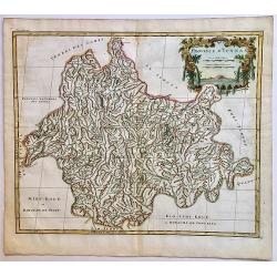
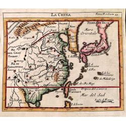
Province d'Yunnan.
Based on Jesuit sources, D'Anville's maps remained the definitive European rendering of China's provinces until the end of the 19th century. This beautiful and detailed D...
Date: 1737
Selling price: ????
Please login to see price!
Sold in 2017
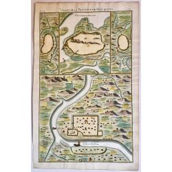
Villes de la Province de Hou-Quang.
A nice example of d'Anville's local town plans of Hubei Province, China from 1737. Includes 4 town plans, including Wuhan, called Vou-Tchang-Fou and a nice map of the Yan...
Date: 1737
Selling price: ????
Please login to see price!
Sold in 2017
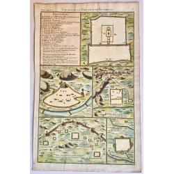
Villes de la Province de Petcheli.
A nice example of d'Anville's local plans of the region around Peking, China in 1737. Shows a town plan of the Forbidden City in Peking, the Great Wall of China, and othe...
Date: 1737
Selling price: ????
Please login to see price!
Sold in 2017
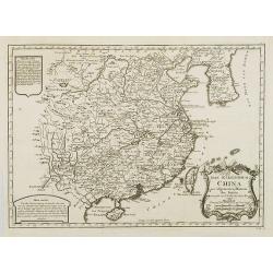
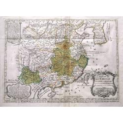
Carte Generale de la Chine Dressée sur les Cartes Particulieres Que l' Empereur Chang-Hi a fait lever sur les lieux..
Large map showing the traditional limits of China, including Hainan and Formosa in the South, and Quantong and parts of the Gobi Desert in the North.As the title notes, t...
Date: Paris , 1737
Selling price: ????
Please login to see price!
Sold in 2018
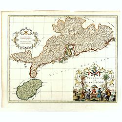
Province de Quang-Tong.
With a quite elaborately pictorial cartouche, engraved by G.Kondet. Very detailed map of Hong Kong and its surroundings. Jean Baptiste Bourguignon d' Anville (1697-1782),...
Date: The Hague 1737
Selling price: ????
Please login to see price!
Sold in 2018
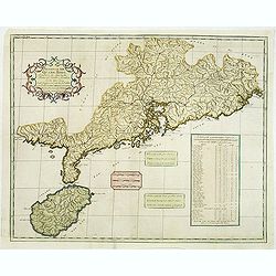
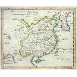
Province XII. Quang-tong. . .
From the rare English text edition of Du Halde's description of China. Showing the area around present-day Hong Kong in good detail. Map of Quang-Tong (Guangdong) showing...
Date: London, 1738
Selling price: ????
Please login to see price!
Sold in 2013
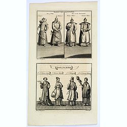
Mandarins, or place-men from du Halde/ Females from du Halde.
Two copperplate engravings on one plate from Duhalde's 'A description of the Empire of China and Chinese Tartary, together with the Kingdoms of Korea & Tibet. The fir...
Date: London, ca. 1738
Selling price: ????
Please login to see price!
Sold in 2019
![[Lot of 2 items] Isoletta Desima Abittata Dagli Olandesi Nel Giappone / Plan du port et de la ville de Nangasaki.](/uploads/cache/84919-250x250.jpg)
[Lot of 2 items] Isoletta Desima Abittata Dagli Olandesi Nel Giappone / Plan du port et de la ville de Nangasaki.
A rare view of the island Deshima with a numbered index table below image. From the Italian translation of T. SALMON, 'Hedendaegsche historie of tegenwoordige staet van a...
Date: Venice, ca 1738
Selling price: ????
Please login to see price!
Sold in 2021
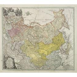
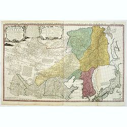
Imperii Russici et Tartariae Universae tam majoris Afiaticæ quam minoris et EuropæTabula.
Decorative map covering Russia, Tibet, China, Tartary, Korea, Taiwan and Japan prepared by J. M. Hasius. With a hefty landmass north of Honshu touching the Asian continen...
Date: Nuremberg, 1739
Selling price: ????
Please login to see price!
Sold in 2009
La Chine.
Lovely example of Giustiniani’s uncommon map of China from his “Atlas Abreviado”.
Date: Amsterdam, 1739
Selling price: ????
Please login to see price!
Sold
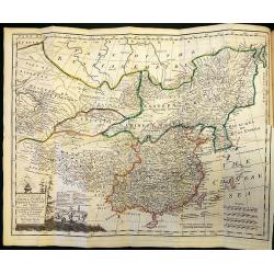
Regni Sinae vel Sinae Propriae Mappa et Descriptio Geographica ..
A highly detailed, excellent map of China based on the works of Du Halde and D'Anville. The map extends from the Gobi desert in the north to Hainan island in the south an...
Date: Nuremberg, ca 1740
Selling price: ????
Please login to see price!
Sold
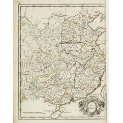
China.
Nice copper engraved map of China including Korea and Formosa (Taiwan) with much topographical detail. With an attractive title cartouche bearing also a distance scale.
Date: London, c1740
Selling price: ????
Please login to see price!
Sold

Nuova carta dell' Imperio della Chia e dei Paesi circonvicini. / Nueva carta de l'Impario de la Quina.
The map is of interest for the use of Mar di Corea" and "Mar Setentrionale del Giapone" in the sea between Korea and Japan.Rare early edition of Albrizzi's...
Date: Venice, 1740
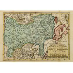
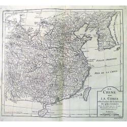
Kaartje van de Chineese Tarters en het land van Jeso..
Attractive and uncommon map of North China with Korea and Jedso. Dutch issue, of this map prepared by de L'Isle. From Atlas Portatif . With a curious and oversized Hokkai...
Date: Deventer, 1742
Selling price: ????
Please login to see price!
Sold in 2011
China.
Charming uncommon Italian map of China, Japan, Korea and Taiwan listed as Tayoun and I.di Formosa. The Great Wall is depicted prominently.
Date: Italy c.1743
Selling price: ????
Please login to see price!
Sold
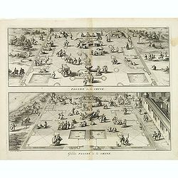
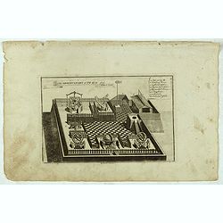
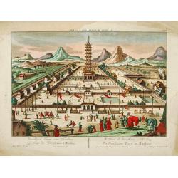
Pagode de la Chine. - Grande Pagode de la Chine.
Two scenes on one page showing scenes on the square of a Pagoda, probably in Changzhou. Fine copper engraving by Bernard Picart and taken from Bernard Picart's famous Cé...
Date: Amsterdam, 1743
Selling price: ????
Please login to see price!
Sold in 2012
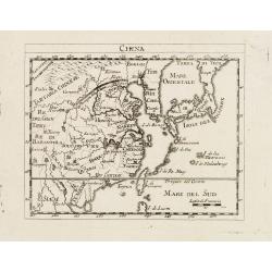
La China.
Smaller format map of China based on the work of De L'Isle.The map is of interest for the use of Sea of Japan / East Sea, the sea between Korea and Japan, here called &qu...
Date: ca. 1743
Selling price: ????
Please login to see price!
Sold in 2012
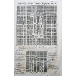
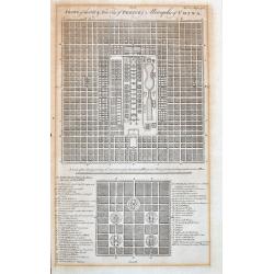
Plans of the Old & New City of Peking ye Metropolis of China.
Two plans of the city, on top new Peking, and below ancient Peking. An extensive legend key identifies around 49 important places such as the Emperor’s residence, remar...
Date: London, 1744
Selling price: ????
Please login to see price!
Sold in 2017
A New & Accurate Map of China.
Emanuel Bowen's map of China based on D'Anville's earlier work.Includes the Korean peninsula, Formosa (Taiwan), and Hainan. With an explanation legend, and text informati...
Date: London, 1744
Selling price: ????
Please login to see price!
Sold in 2017
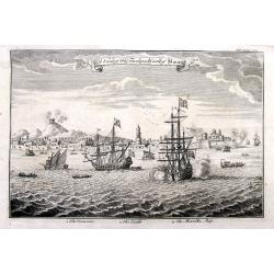
A View of the Town and Castle of Macao.
Nice view of the town seen from the sea. Numerous buildings and ships shown. With the British ship Centurion in the foreground firing cannons, and the return fire is seen...
Date: London, 1744
Selling price: ????
Please login to see price!
Sold in 2018
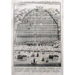
A Plan of the City of Canton on the River Ta ho.
An early plan of Guangzhou, with many buildings and ships shown. A key names 13 places, including the King's Palace, Young Kings's Palace, The City Wall, and two Floating...
Date: London, 1744
Selling price: ????
Please login to see price!
Sold in 2017
Plans of the Old & New City of Peking ye Metropolis of China.
Two early plans of the city, on top the new Peking, and below the ancient Peking. With an extensive legend key that identifies around 49 important places such as the Empe...
Date: London, 1744
Selling price: ????
Please login to see price!
Sold in 2021
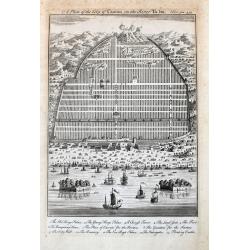
A Plan of the City of Canton on the River Ta ho.
An early and decorative plan of Guangzhou, with many buildings and ships shown. A key names 13 places, including the King's Palace, Young Kings's Palace, The City Wall, a...
Date: London, 1744
Selling price: ????
Please login to see price!
Sold in 2021
Nouvelle Carte de l'Empire de la Chine et les Païs circomvoisins.
A map of China by Izaak Tirion, also showing Korea and Japan.Isaak Tirion (d. 1769) Amsterdam publisher. His "Nieuwe en beknopte handatlas" saw 6 editions betwe...
Date: Amsterdam, c. 1745
Selling price: ????
Please login to see price!
Sold in 2019
![The History of the Court of the King of China [with] An Account of the Empire of China. . .](/uploads/cache/99680-250x250.jpg)
The History of the Court of the King of China [with] An Account of the Empire of China. . .
Complete account extracted from a contemporary collection of voyages in French and Spanish and translated into English. Includes a map of China by Herman Moll.
Date: London, 1745
Selling price: ????
Please login to see price!
Sold in 2012
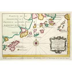
Carte plate qui comprend les Costes de Tsiompa, de la Cochinchine, le golfe de Tunquin, une partie des costes de la Chine avec une partie de l'Archipel des Isles Philippines. . .
Important French of the China Sea with the coast of Southern China, including Hong Kong and the southern tip of Taiwan. Great detail on the Philippines.Engraved by Guill...
Date: Paris, Jean-François Robustel, 1745
Selling price: ????
Please login to see price!
Sold
Das Kaiserthum China zur allgemeinen Historie der Reisen - entworfen von N. Bellin Ing. de la Mar. 1748.
Attractive and detailed map of China and Korea. The Sea of Japan is labeled "Das meer von Korea". The composition is nicely balanced with three decorative carto...
Date: Leipzig, Arkstee & Merkus, 1746
Selling price: ????
Please login to see price!
Sold in 2008
Das Kaiserthum China zur allgemeinen Historie der Reisen - entworfen von N. Bellin Ing. de la Mar. 1748.
Attractive and detailed map of China and Korea. The Sea of Japan is labeled "Das meer von Korea". The composition is nicely balanced with three decorative carto...
Date: Leipzig, Arkstee & Merkus, 1746
Selling price: ????
Please login to see price!
Sold
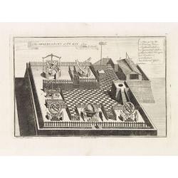
The observatory of Peking from Le Comte.
The observatory in Peking, in which there are very large instruments, an Equinoctial Sphere, a Celestial Globe, a Zodiacal Sphere, Azimuthal Horizona, Quadrant, and a Sex...
Date: London, 1746
Selling price: ????
Please login to see price!
Sold in 2014
A New & Accurate Map of China. Drawn from Surveys made by the Jesuit Missionaries, by Order of the Emperor
Bowen's map of China from 'A Complete System of Geography'. With an elaborate allegorical cartouche and a compass rose. Includes Korea and Formosa and advertising notes a...
Date: London, 1747
Selling price: ????
Please login to see price!
Sold in 2010
![Kaartje Van TKeizer-Ryk China... [two maps]](/uploads/cache/92001-250x250.jpg)
Kaartje Van TKeizer-Ryk China... [two maps]
Two rare maps based on the work of De L'Isle, one of the Empire of China and a second of Chinese Tartary, including Korea and an oversized Hokkaido.
Date: Deventer, 1747
Selling price: ????
Please login to see price!
Sold in 2012
A Map of Great Tibet drawn from that made by Lama Mathematicians in 1717.
Uncommon map of the Gobi Desert, Kashgar regions with Tibet. Drawn from indigenous sources, including the Dalai Lama's mathematicians and engraved by G. Child - with his ...
Date: London, 1745-1747
Selling price: ????
Please login to see price!
Sold in 2015
The observatory of Pe-kin from Le Comte.
Print of the observatory of Peking after Le Comte who visited the Peking Observatory in 1688. Engraved by G. Child - with his signature in lower bottom.From Astley, Thoma...
Date: London, 1745-1747
Selling price: ????
Please login to see price!
Sold in 2016
L'Empire de la Chine.
A fine map of China, Korea and Taiwan.Jacques Nicholas Bellin (1703-1772) was one of the most important and proficient French cartographers of the mid-eighteenth century....
Date: Paris 1748
Selling price: ????
Please login to see price!
Sold
L'Impero della China Per uso della Storia generale de'Viaggi.
Rare uncommon Italian variant of Bellin's three-cartouche map of China. This map shows locations of ethnic groups and communities in China, Korea, and Mongolia. The map s...
Date: Paris, 1748
Selling price: ????
Please login to see price!
Sold in 2008
L'Empire de la Chine.
Beautiful example of Bellin's classic map of China with information provided in three delicately engraved cartouches.
Date: Paris, 1748
Selling price: ????
Please login to see price!
Sold in 2009
La Chine avec La Coree. . .
Fine map of China, Korea and Taiwan (named as Tayouan ou Formose I.). Prepared after Jesuit sources from 1708-1717.The map is of interest for the use of "Kao-Liqoue ...
Date: Paris, 1748
Selling price: ????
Please login to see price!
Sold in 2012
Carte L'Empire de la Chine, de la Tartarie Chinoise..
A fine map of China, Korea, Japan and Taiwan, prepared by R.Bonne and included in his Atlas Ecyclopédique.. Rigobert Bonne (1727-1795) was engineer, mathematician and ca...
Date: Paris, 1748
Selling price: ????
Please login to see price!
Sold in 2013
L' Empire de La Chine...
Detailed map of China and South Korea, with parts Mongolia, Tartar regions, and also showing Hainan and Formosa (Taiwan). With numerous cities shown: Canton, Macao, Pekin...
Date: Paris, ca. 1748
Selling price: ????
Please login to see price!
Sold in 2015
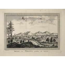
Gezigt van Peking, getrokken uit Nieuhof
This view of Peking is based on an engraging from the publication ''''Het Gezantschap der Neêrlandtsche Oost-Indische Compagnie, aan den grooten Tartarischen Cham, den t...
Date: 1749
Selling price: ????
Please login to see price!
Sold in 2008
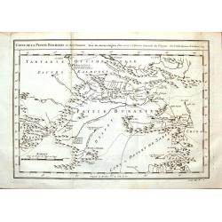
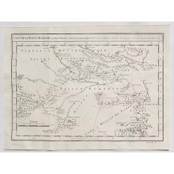
Carte de la Petite Bukharie et Pays Voisins.
Fine copper engraved map covering entire Sinkiang, the Tarim Basin, Djungariet and Turfan and the Pamirs in the west to the Chinese Wall beginning in the East. Engraved b...
Date: Paris, 1749
Selling price: ????
Please login to see price!
Sold in 2016
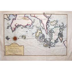
Carte de L'isle de Cheu-Chan.
Striking map of the area of China, east of Ningbo in Chekiang Province across from Shanghai. The map was by Bellin in 1749. Interestingly, the large, detailed compass ...
Date: Paris, 1749
Selling price: ????
Please login to see price!
Sold in 2019
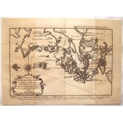
l'Isle de Cheu-chan ou Isle de Chusan.
A striking map of of Cheu-Chan in the province of Che-Kiang and surrounding islands in China. It was published in "HISTOIRE GENERALE DES VOYAGES" by Prevost in ...
Date: Paris, 1749
Selling price: ????
Please login to see price!
Sold in 2019
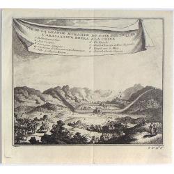
Vue de la Grande Muraille du Cote par Lequel L'Ambassadeur Entra a la Chine.
Fine little copper engraving from "HISTOIRE DES VOYAGES" by Abbe Prevost. It was published by Didot in Paris in 1748. Interesting banner cartouche.
Date: Paris, 1749
Selling price: ????
Please login to see price!
Sold in 2016
Carte de la Petite Bukarde et Pays Voisins. . .
Antique map of Central Asia (Turpan) of China. Petit Bukaharie or Xinjiang, known for the more two thousand years old Silk road. By Bellin in 1749.Jacques Nicolas Bellin ...
Date: Paris, 1749
Selling price: ????
Please login to see price!
Sold in 2020
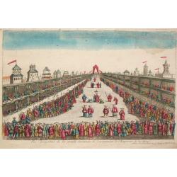
Vue perspective de la grande Ceremonie du couronnement de l'Empereur de la Chine.
An optical view of the coronation ceremony of the Chinese emperor.
Date: Paris, c. 1750
Selling price: ????
Please login to see price!
Sold
Regni Sinae vel Sinae Propriae Mappa et Descriptio Geographica.
China with the islands of Formosa and Hainan. Copper engraved map in contemporary color after du Halde and d'Anville by John Matth. Hase, published by the heirs of J.-B. ...
Date: Nuremberg, c. 1750
Selling price: ????
Please login to see price!
Sold in 2013
![[SET OF 7 MAPS OF CHINA, ca. 1750]](/uploads/cache/91735-250x250.jpg)
[SET OF 7 MAPS OF CHINA, ca. 1750]
Interesting set of seven regional copper-engraved maps and plans of China by or after Bellin, dating to around 1750. List of the maps: 1: Carte des isles qui sont a l'en...
Date: Paris, 1750
Selling price: ????
Please login to see price!
Sold in 2011

L'Empire de la Chine. . .
Detailed map of China, Korea and Taiwan. The large title cartouche is resplendent in the French style with musicians, a dancer, and various accouterments representative o...
Date: Paris, dated 1750
(Map of China, Korea and Japan)
A large detailed map of China, Korea and Japan prepared and published by Jean Baptiste Bourguignon d’Anville. This is the upper part of his two-sheet map of the Far Eas...
Date: Paris, c. 1750
Selling price: ????
Please login to see price!
Sold in 2014

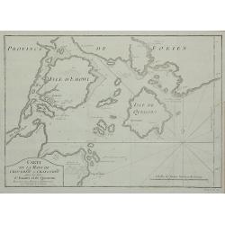
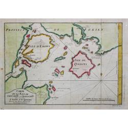
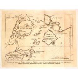
Carte de la Baye de Chin-Chew ou Chang-Chew avec les Isles d'Emowi et de Quimowi
A copper engraved chart of the estuary of the Chiu-lung River at present-day Hsia-men, on the mainland coast, adjacent to Taiwan. Chart shows the location of a few villag...
Date: Paris, c1750
Selling price: ????
Please login to see price!
Sold in 2016
L'Empire de la Chine dressé d'après les cartes de l'Atlas Chinois...
A detailed, large map of China, Korea and Taiwan. The large and spectacular title cartouche is in the typical French style, with musicians, a dancer, and various details ...
Date: Paris, ca 1750
Selling price: ????
Please login to see price!
Sold in 2016
L'Empire de la Chine..
Detailed map of China, Korea and Taiwan. Decorative cartouche lower right.
Date: Paris 1751
Selling price: ????
Please login to see price!
Sold
L'Empire de la Chine ...
Detailed map of China, Korea and Taiwan. Decorative cartouche lower right.
Date: Paris, 1751
Selling price: ????
Please login to see price!
Sold in 2011
L'Empire de la Chine..
Detailed map of China, Korea and Taiwan. Decorative cartouche lower right showing natives.
Date: Paris, 1751
Selling price: ????
Please login to see price!
Sold in 2012
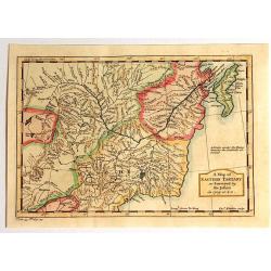
A Map of Eastern Tartary as Surveyed by the Jesuits in 1709, 1710 & 1711.
A fine map of Eastern Tartary that shows parts of present-day Russia, Mongolia, and China, and was based on the work of Jesuit cartographer Jean-Baptiste Regis.In the bot...
Date: London, 1751
Selling price: ????
Please login to see price!
Sold in 2015
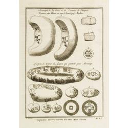
Monnoyes de la Chine et du Royaume de Tunquin. - Lingots d\'Argent du Japon qui passent pour Monnoye. Pl. VI.
Decorative print illustrating coins and silver ingots from China and Japan. From Histoire générale des voyages.. by Antoine François Prévost.Titles in French and Dutc...
Date: Paris, 1752
Selling price: ????
Please login to see price!
Sold in 2008
![Nieuwe Pas=Caart strekkende van Pta Cataon tot Pta. Lamtoan, langs de kusten van Cochinchina, Tonquin, Quangsi en Quantung [?] van Macao.](/uploads/cache/23818-250x250.jpg)
Nieuwe Pas=Caart strekkende van Pta Cataon tot Pta. Lamtoan, langs de kusten van Cochinchina, Tonquin, Quangsi en Quantung [?] van Macao.
A finely engraved and detailed chart of Vietnam reaching till Macao and present-day Hong Kong..Very rare: only included in 6th volume (so-called secret atlas) of Van Keul...
Date: Amsterdam 1753
Selling price: ????
Please login to see price!
Sold
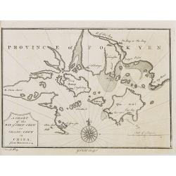
PROVINCE OF FOKYEN A chart of the Bay of Chin-Chew or Chang-Chew in China.
A small but very early and interesting map, engraved by G.Child for \'The Universal Traveller\', by Thomas Salmon.Covers that part of the coastline from Pu-tay Point, dow...
Date: London, Th. Salmon, 1729-1753
Selling price: ????
Please login to see price!
Sold in 2008
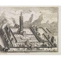
Temple of Paulin near Nankin.
A small but very early and interesting engraving by J. Basire for 'The Universal Traveller', by Thomas Salmon. A pleasing and uncommon mid-18th century birds-eye view (li...
Date: London, Th. Salmon, 1729-1753
Selling price: ????
Please login to see price!
Sold in 2008
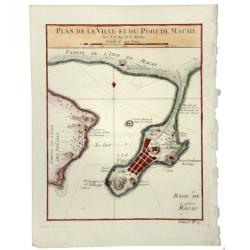
PLAN DE LA VILLE ET DU PORT DE MACAO.
A fine early map of Macao, published by Nicholas Bellin, the French Royal Hydrographer.
Date: Paris, 1753
Selling price: ????
Please login to see price!
Sold in 2020
Carte de la Baye de Chin-Chew ...
A detailed small chart of the estuary of the Chiu-lung River at present-day Hsia-men, on the mainland coast, adjacent to Taiwan, showing the location of a few village set...
Date: Paris, 1754
Selling price: ????
Please login to see price!
Sold in 2011
KejserDommet China udkastet til den almindelige Reise-beskrivelse af N. Bellin Ing. de la Mar. 1748.
Extremely rare Danish issue of Bellin's three cartouche map of China. Bellin added this map to the Prevost itinerary, which has been published in French, Dutch, German, a...
Date: Copenhagen, 1754
Selling price: ????
Please login to see price!
Sold in 2013
China.
A nice mid-eighteenth century map of China, extending from the island of Haynan in the south, to the Kobi Desert in the north, from Lake Puka in Tibet in the west to Kore...
Date: London, ca. 1754
Selling price: ????
Please login to see price!
Sold in 2017
Tatariae Sinensis mappa Geographica. . .
A fine large-scale map derived from d'Anville and prepared by Johann Tobias Mayer . Including far western China and Mongolia, Japan, Korea and Manchuria. Dense with old p...
Date: Nuremberg, 1755
Selling price: ????
Please login to see price!
Sold in 2011
![[Two maps] Tatariae Sinensis mappa Geographica... [together with] Regni Sinae vel Sinae propriae. . .](/uploads/cache/33797-250x250.jpg)
[Two maps] Tatariae Sinensis mappa Geographica... [together with] Regni Sinae vel Sinae propriae. . .
Tatariae Sinensis mappa Geographica A fine large-scale map derived from d'Anville and prepared by Johann Tobias Mayer . Including far western China and Mongolia, Japan, K...
Date: Nuremberg, 1755
Selling price: ????
Please login to see price!
Sold in 2013
History of China, the Modern History, By Way of Sequel to Mr. Rollin's Ancient History.
A rare book translated from French and printed for J.& P. Knapton. The volume is divided into a number of parts, covering a general history of China; a description of...
Date: London, 1755
Selling price: ????
Please login to see price!
Sold in 2018
La Chine.
Fine map of China, with in lower right corner Taiwan and a large decorative title cartouche. George Louis Le Rouge was active from 1740- till 1780 as a publisher, and was...
Date: Paris, 1756
Selling price: ????
Please login to see price!
Sold
Carte de la Tartarie Occidentale Pour Servir a L'Histoire Generale des Voyages Tiree des Auteurs Anglois.
A map of Western Tartary, covering present-day Northern China and Mongolia. The site of Genghis Khan's ancient Mongol capital of Karakum (Karakorum) is centrally marked o...
Date: Paris, 1758
Selling price: ????
Please login to see price!
Sold in 2019
Carte de la Baye de Chin-Chew. Avec les Isles de Emowi et de Quemowi.
Jaques Nicolas Bellin (1702-720) was the most important French hydrographer of the 18th century. Sea-atlas 'Hydrographique Français' , 1756-65, atlas to accompany Prévo...
Date: Amsterdam, 1759
Selling price: ????
Please login to see price!
Sold
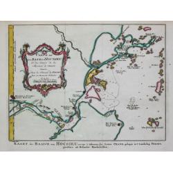
Carte de la Baye d?Hocsieu.
Jaques Nicolas Bellin (1702-720) was the most important French hydrographer of the 18th century. Sea-atlas 'Hydrographique Français' , 1756-65, atlas to accompany Prévo...
Date: Amsterdam, 1759
Selling price: ????
Please login to see price!
Sold
Carte des Isles... de la Rivière de Canton.
Jaques Nicolas Bellin (1702-720) was the most important French hydrographer of the 18th century. Sea-atlas 'Hydrographique Français' , 1756-65, atlas to accompany Prévo...
Date: Amsterdam, 1759
Selling price: ????
Please login to see price!
Sold
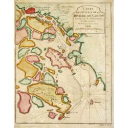
Carte del? Entrée de la Rivière de Canton.
Jaques Nicolas Bellin (1702-720) was the most important French hydrographer of the 18th century. Sea-atlas 'Hydrographique Français' , 1756-65, atlas to accompany Prévo...
Date: Amsterdam, 1759
Selling price: ????
Please login to see price!
Sold
Kaart der Baai van Chin-Chew, of Chang-Chew.
This map features the Bay of Changchow in the Fukien province. The map features a floral title cartouche. The Dutch title is at the bottom.
Date: Paris, 1759
Selling price: ????
Please login to see price!
Sold in 2018
La Tour de Porcellaine à Nanking.
A well-known publisher of optical prints, established in Augsburg. After a design by P.van Blankaert.In the eighteenth and nineteenth centuries there were many popular sp...
Date: Augsburg 1760
Selling price: ????
Please login to see price!
Sold
