Browse Listings in Asia
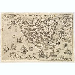
La famosa citta de Constantinopoli.
A separately published decorative and very rare panoramic of of present-day Istanbul, viewed from the village of Scutari. The City is shown with all its fortifications, ...
Date: Venice, c. 1570
Selling price: ????
Please login to see price!
Sold in 2013
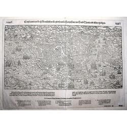
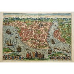
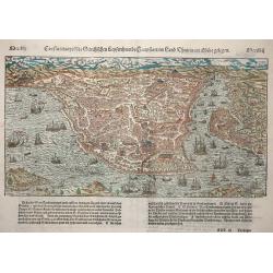
Constantinopel.
An early, fine, extremely detailed woodcut depicting a bird's-eye view of Istanbul as seen from the perspective showing it out on a spur, with Pera across the water to th...
Date: Basle, ca. 1570
Selling price: ????
Please login to see price!
Sold in 2022
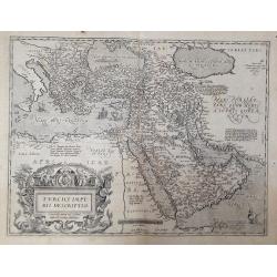
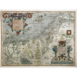
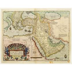
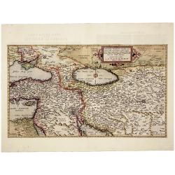
Turcici imperii descriptio.
From Ortelius' 'Theatrum Orbis Terrarum', the first regularly produced, and uniform format, modern atlas of the World. Reference literature: MARCEL P.R. van den Broecke, ...
Date: Antwerp, 1570
Selling price: ????
Please login to see price!
Sold in 2020
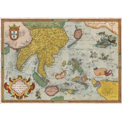
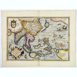
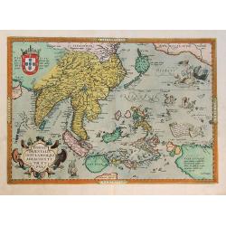
Indiae Orientalis, Insularumque Adiacientium Typus.
Finely contemporarily handcolored example of Ortelius' map of SE Asia, Japan, and the Philippines, etc. The map includes Beach and other information drawn from Marco Polo...
Date: Antwerpen, 1571
Selling price: ????
Please login to see price!
Sold in 2009
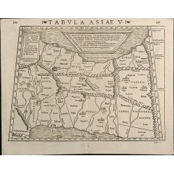
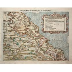
Tabula Asiae V
Woodcut map showing Persia between Persian Gulf and Caspian Sea. From the Latin 1571 edition of Strabo's Geographia with maps of Sebastian Munster which appeared in Ptole...
Date: Basle, 1571
Selling price: ????
Please login to see price!
Sold in 2013
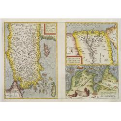
Natoliae quae olim asia minor? / Aegypti recentior? / Carthaginis celeberimisinus typus.
colored copper engraved map of Turkey by A. Ortelius. On right side a map of Egypt and one of Tunis. Three map on one sheet printed from one plate. From the 1571 Latin ed...
Date: Antwerp, c. 1571
Selling price: ????
Please login to see price!
Sold in 2010
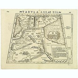
Tabula Asiae III
Attractive woodblock Ptolemaic map, depicting Armenia and in the Right part of the Caspian Sea with Noes Arch. The mountain ranges are depicted in the manner of the early...
Date: Basle, Strabo, 1571
Selling price: ????
Please login to see price!
Sold in 2012
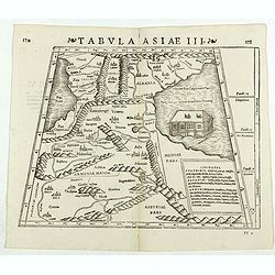
Tabula Asiae III. (Armenia)
Double-page woodcut Ptolemaic-style map by Sebastian Münster figuring Armenia, published in the edition of Strabo by Henri Petri in 1571."Strabonis rerum geographic...
Date: Basle, Henri Petri, 1571
Selling price: ????
Please login to see price!
Sold in 2018
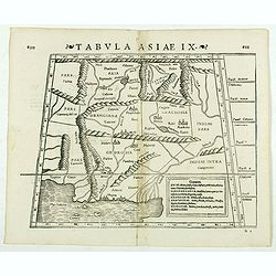
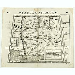
Tabula Asiae IX. (Pakistan, including part of India)
Double-page woodcut Ptolemaic-style map by Sebastian Münster figuring Pakistan, including part of India, published in the edition of Strabo by Henri Petri in 1571."...
Date: Basle, Henri Petri, 1571
Selling price: ????
Please login to see price!
Sold in 2019
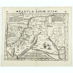
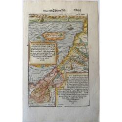
Tabula Asiae IIII. (Holy Land)
Double-page woodcut Ptolemaic-style map by Sebastian Münster figuring Holy Land, published in the edition of Strabo by Henri Petri in 1571."Strabonis rerum geograph...
Date: Basle, Henri Petri, 1571
Selling price: ????
Please login to see price!
Sold in 2019
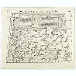
Tabula Asiae I. (Turkey)
Double-page woodcut Ptolemaic-style map by Sebastian Münster figuring Turkey, published in the edition of Strabo by Henri Petri in 1571."Strabonis rerum geographica...
Date: Basle, Henri Petri, 1571
Selling price: ????
Please login to see price!
Sold in 2018
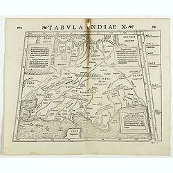
Tabula Indiae X. (part of India and the Indian Ocean)
Double-page woodcut Ptolemaic-style map by Sebastian Münster figuring part of India and the Indian Ocean, published in the edition of Strabo by Henri Petri in 1571."...
Date: Basle, Henri Petri, 1571
Selling price: ????
Please login to see price!
Sold in 2022
Tabula Asiae IX. (North India and Pakistan)
Double-page woodcut Ptolemaic-style map by Sebastian Münster figuring North India and Pakistan, published in the edition of Strabo by Henri Petri in 1571."Strabonis...
Date: Basle, Henri Petri, 1571
Selling price: ????
Please login to see price!
Sold in 2020
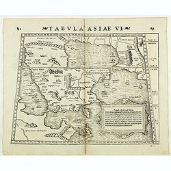
Tabula Asiae VI. ( Arabian Peninsula)
Double-page woodcut Ptolemaic-style map by Sebastian Münster figuring Arabian Peninsula, published in the edition of Strabo by Henri Petri in 1571."Strabonis rerum ...
Date: Basle, Henri Petri, 1571
Selling price: ????
Please login to see price!
Sold in 2018
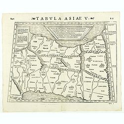
Tabula Asiae V. ( Eastern Iraq and western Iran)
Double-page woodcut Ptolemaic-style map by Sebastian Münster figuring Eastern Iraq and western Iran, published in the edition of Strabo by Henri Petri in 1571."Stra...
Date: Basle, Henri Petri, 1571
Selling price: ????
Please login to see price!
Sold in 2019
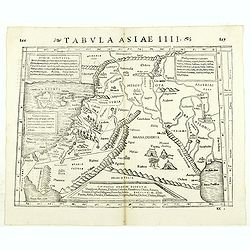
Tabula Asiae IIII. ( Holy Land, Cyprus, Syria, etc.)
Double-page woodcut Ptolemaic-style map by Sebastian Münster figuring Holy Land, Cyprus, Syria, etc., published in the edition of Strabo by Henri Petri in 1571."Str...
Date: Basle, Henri Petri, 1571
Selling price: ????
Please login to see price!
Sold in 2018
![[Cyprus].](/uploads/cache/41984-250x250.jpg)
[Cyprus].
Woodcut Ptolemaic-style map by Sebastian Münster figuring Cyprus, published in the edition of Strabo by Henri Petri in 1571."Strabonis rerum geographicarum" is...
Date: Basle, Henri Petri, 1571
Selling price: ????
Please login to see price!
Sold in 2018
Terra Sancta.
Full title in an elaborate cartouche with scenes from the live of Christ in vignettes at top right: 'Terra Sancta, a Petro Laicstain perlustrata, et ab eius ore et schedi...
Date: Antwerp, 1571
Selling price: ????
Please login to see price!
Sold in 2021
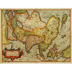
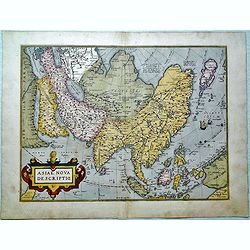
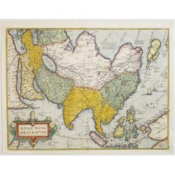
Asiae nova descriptio.
Ortelius' fine map of Asia well represents the continent at a time when Europeans were expanding their power in the far east. The Indian subcontinent and Malaysian penins...
Date: Antwerp 1572
Selling price: ????
Please login to see price!
Sold
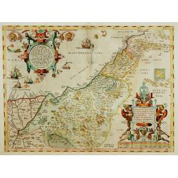
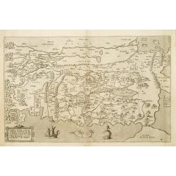
Palestinae sive totius terrae promissionis nova..
A new description of Palestine or the whole Promised Land. The shoreline runs from Berytus (Beirut) to the Nile Delta, reaching inland east of the Jordan and in the south...
Date: Antwerp 1572
Selling price: ????
Please login to see price!
Sold
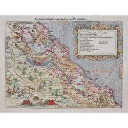
Das hehlig Judisch land mit. . .
This is Sebastian Munster's interesting and detailed double-page map of the Holy Lands from his Cosmographia. The map shows from Sidon and the land of the Phoenicians in...
Date: Basel, (1540) 1572
Selling price: ????
Please login to see price!
Sold in 2012
Tabula Terrae Canaan Abrahae tempore et ante adventum?
Map of Canaan at the times of Abraham and before the conquest by the Children of Israel, with the neighboring regions. Oriented to the east. The shore line runs from Turk...
Date: Antwerp, 1572
Selling price: ????
Please login to see price!
Sold
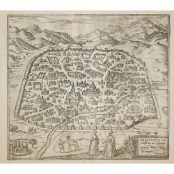
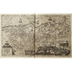
Damascus, urbs.
Early view of Damascus, a town-plan from the greatest publication in this genre !. The ,Civitates, was compiled and written by George Braun, Canon of Cologne Cathedral. B...
Date: Cologne 1572
Selling price: ????
Please login to see price!
Sold in 2011
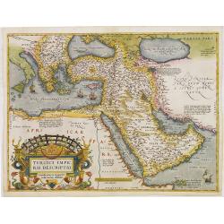
Turcici Imperii Descriptio.
This is Ortelius uncommon first map of the Turkish Empire only used from 1570 until 1579. This is the best known of all the sixteenth-century maps of the Middle East, ext...
Date: Antwerp, 1572
Selling price: ????
Please login to see price!
Sold in 2012
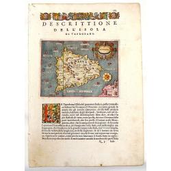
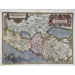
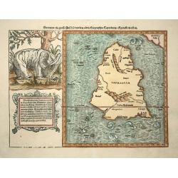
Descrittione del l'Isola di Taprobana.
Charming map of the island of Sri Lanka (Celon). The map is oriented with north to the right. Fancy strapwork cartouche with two faces and a unique compass rose. Printed ...
Date: Venice, 1572
Selling price: ????
Please login to see price!
Sold in 2013
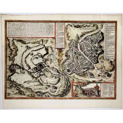
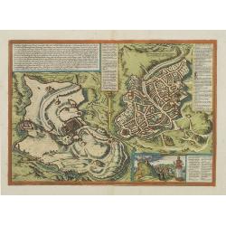
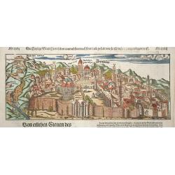
Hierosolyma, Clarrisima Totius Orientis Civitas ludaee Metropolis... (Jerusalem)
A very fine, decorative map with a double-view of Jerusalem depicts Biblical Jerusalem and the modern city during the 16th century. Biblical Jerusalem appears on the left...
Date: 1572
Selling price: ????
Please login to see price!
Sold in 2019
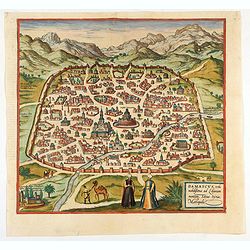
Damascus, urbs.
Early view of Damascus, a bird's eye view from the greatest publication in this genre ! The Civitates was compiled and written by George Braun, Canon of Cologne Cathedral...
Date: Cologne, 1572
Selling price: ????
Please login to see price!
Sold in 2020
Tartariae sive Magni Chami Regni.
Beautiful old color example of Ortelius' map of Tartary, Japan and the West Coast of North America, from the early 1573 Latin edition Ortelius' Theatrum Orbis Terarrum, t...
Date: Antwerp, 1573
Selling price: ????
Please login to see price!
Sold in 2014
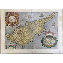
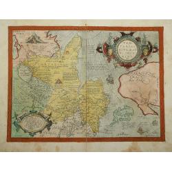
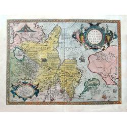
Cypri insulae nova descript.
A milestone in the history of cartography of Cyprus, based on a 1570 map by Giacomo Franco. The map is embellished by sailing ships and a sea monster, bearing a map of Le...
Date: Antwerp, 1573
Selling price: ????
Please login to see price!
Sold in 2020
Tartariae sive Magni Chami Regni typus. . .
An early edition of the famous and important map of Tartary, Japan, and the west coast of North America, from Ortelius'Theatrum Orbis Terarrum, the first modern atlas of ...
Date: Antwerp, ca 1573
Selling price: ????
Please login to see price!
Sold in 2018
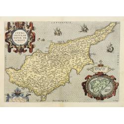
Cypri Insulae Nova descript. 1573.
This is a beautiful copy of a classic map of Cyprus. It is the earliest obtainable version of the best map of Cyprus made to date. Ortelius based his map upon that publis...
Date: Antwerp, 1574
Selling price: ????
Please login to see price!
Sold in 2011
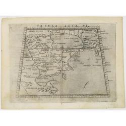
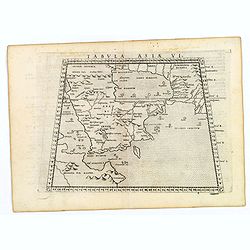
Tabula Asiae VI.
The ancient depiction of Arabia, based on Claudius Ptolemy's Geographia from the second century A.D. The region appears with many interior mountains and rivers: none of w...
Date: Venice, 1561-1574
Selling price: ????
Please login to see price!
Sold in 2016
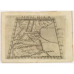
Tabula Asiae III
The ancient depiction of the region between the Black Sea and Caspian Sea extending south to include all of Armenia Maior and part of Armenia Minoris, based on Claudius P...
Date: Venice, 1561-1574
Selling price: ????
Please login to see price!
Sold in 2014
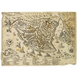
Constantinopoli.
Uncommon plan of Istanbul from Giovanni Francesco Camocio. In the lower right corner, "appresso Gioan Francesco Camocio." Oriented with north toward the upper r...
Date: Venice, ca. 1574
Selling price: ????
Please login to see price!
Sold in 2010
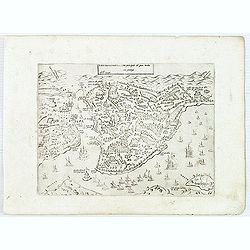
Costantinopoli città principale del gran turcho. . .
Uncommontown-plan of Constantinople. From Giovanni Francesco Camocio's rare " Isole Famose porti, fortezze, e terre maritime . . ." issued by Bertelli. The seco...
Date: Venice, D.Bertelli, ca.1574
Selling price: ????
Please login to see price!
Sold in 2015
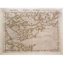
Arabia Felice Nuova Tavola.
A classical map of the Arabian Peninsular, is an enlarged version of Giacomo Gastaldi's published in 1548. Girolamo Ruscelli's edition of Ptolemy's Geographia included ne...
Date: Venice, 1574
Selling price: ????
Please login to see price!
Sold in 2014
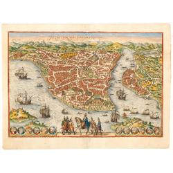
Byzantium nunc Constantinopolis.
One of the finest and most sought-after views of Istanbul. Viewed from the village of Scutari, the City is shown with all its fortifications, the original Genoese distric...
Date: Cologne, ca. 1574
Selling price: ????
Please login to see price!
Sold in 2014
Asiae nova descriptio.
Ortelius' fine map of Asia well represents the continent at a time when Europeans were expanding their power in the Far East. The Indian subcontinent and Malaysian penins...
Date: Antwerp, 1574
Selling price: ????
Please login to see price!
Sold in 2015
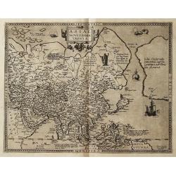
![[Asia Minor]](/uploads/cache/35967-250x250.jpg)
[Asia Minor]
Early, attractive hand-colored woodcut map of Turkey, with an unnamed Cyprus in the lower right corner. From the German edition of Sebastian Münster's Cosmography, title...
Date: Basle, ca. 1574
Selling price: ????
Please login to see price!
Sold in 2016
![Tabula Asiae VI. [Arabian Peninsular]](/uploads/cache/39790-250x250.jpg)
Tabula Asiae VI. [Arabian Peninsular]
The ancient depiction of Arabia, based on Claudius Ptolemy's Geographia from the second century A.D. The region appears with many interior mountains and rivers: none of w...
Date: Venice, 1574
Selling price: ????
Please login to see price!
Sold in 2017
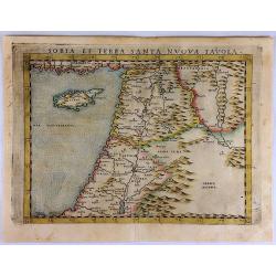
Soria et Terra Santa Nuova Tavola.
Ruscelli's map of the Holy Land, Syria and Cyprus. One of the earliest obtainable separately published maps of the region. The map first appeared in the 1561 edition of R...
Date: Venice, 1574
Selling price: ????
Please login to see price!
Sold in 2017
Tabula Asiae VI. (Arabian Peninsular)
A lovely example of this classical map depicting an ancient representation of the Arabian Peninsula, based on Ptolemy's second century A.D. Geographia here called Arabia ...
Date: Venice, 1574
Selling price: ????
Please login to see price!
Sold in 2020
Indiae Orientalis, Insularumque Adiacientium Typus. . .
A finely hand colored example of Ortelius' highly decorative map of South East Asia, Japan, and the Philippines, etc from the Latin text edition of 1574. The map includes...
Date: Antwerp, 1574
Selling price: ????
Please login to see price!
Sold in 2018
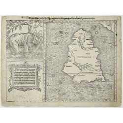
Sumatra ein grosse Insel, so von den alten Geographen Taprobana, ist genent worden (Sri Lanka).
A nice impression of this great map of island of Tabrobana, which was variously thought to be Ceylon or Sumatra. This map depicts Ceylon with the typical misconceptions o...
Date: Basle, 1574
Selling price: ????
Please login to see price!
Sold in 2021
Byzantium nunc Constantinopolis.
One of the finest and most sought-after views of Istanbul. Viewed from the village of Scutari, the City is shown with all its fortifications, the original Genoese distric...
Date: Cologne, ca 1574
Selling price: ????
Please login to see price!
Sold in 2019
Palestinae sive totius terrae promissionis nova description (....)
A fine example of Ortelius' map of the Holy Land, published in his "Theatrum Orbis Terrarum", the first modern atlas. This famous map by Ortelius is based on th...
Date: Antwerp, ca 1574
Selling price: ????
Please login to see price!
Sold in 2021
Byzantium Nunc Constantinopolis
This marvelous engraving of Constantinople in original color is from an early edition of Braun & Hogenberg's Civitates Orbis Terrarum, the most prolific compilation o...
Date: Cologne, 1574
Selling price: ????
Please login to see price!
Sold in 2023
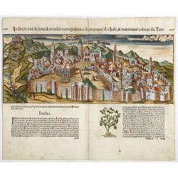
La Sainte cité de Jérusalem jadiz métropolitaine du royaume des juifz...
A particularly attractive example of this early wood cut view of Jerusalem. The city appears well laid out, and is surrounded by a vast wall.Included in a French text edi...
Date: Paris, 1575
Selling price: ????
Please login to see price!
Sold in 2017
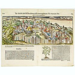
La Sainte cité de Jérusalem jadiz métropolitaine du royaume des juifz...
A particularly attractive example of this early wood cut view of Jerusalem. The city appears well laid out, and is surrounded by a vast wall.Included in a French text edi...
Date: Paris, 1575
Selling price: ????
Please login to see price!
Sold in 2014
Turcici Imperii Descriptio.
Map of the Middle East, extending from Greece to Arabia and covering the Cradle of Civilisation region. This is rare FIRST PLATE only used until 1579. Based on Gastaldi's...
Date: Antwerp 1575
Selling price: ????
Please login to see price!
Sold
Asiae nova descriptio.
The much rarer first plate of Ortelius' fine map of Asia. The first plate has "La Farfana", in the lower right corner. It is estimated that only 1575 copies are...
Date: Antwerp, 1575 - 1575
Selling price: ????
Please login to see price!
Sold in 2008
Hierosolymia, Clarissima totius Orientis civitas.
Two bird's eye perspectives town-plans on one sheet. The left plan shows ancient Jerusalem at the time of Christ. A contemporary view of Jerusalem appears to the right wi...
Date: Cologne, 1575
Selling price: ????
Please login to see price!
Sold in 2015
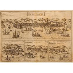
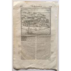
Calechut Celeberrimum Indiae Emporium
Birdeye view of Kozhikode (Calicut) with ships and elefants.
Date: Cologne, 1575
Selling price: ????
Please login to see price!
Sold in 2009
![[ Noe's Ark caught in a storm ].](/uploads/cache/27241-250x250.jpg)
[ Noe's Ark caught in a storm ].
On verso a woodcut of Noe's Ark caught in a storm.From a French text edition of his Cosmographia , that great compendium of Renaissance knowledge. In 1575 Sebastian Müns...
Date: Basle, ca.1575
Selling price: ????
Please login to see price!
Sold in 2018
Asie.
Uncommon wood-cut map of Asia. New Guinea has disappeared and Japan is represented as a turtle-shaped island. An important innovation is the appearance of the Straits of ...
Date: Paris, 1575
Selling price: ????
Please login to see price!
Sold in 2010
Indiae Orientalis, insularumque adiacentium typus.
Fine example of Ortelius' map of SE Asia, Japan, and the Philippines, etc. The map includes Beach and other information drawn from Marco Polo, portion of the West Coast o...
Date: Antwerp, 1575
Selling price: ????
Please login to see price!
Sold in 2011
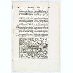
(Arch of Noah.)
Wood block engraved print of the Arch of Noah, from "La Cosmographie Universelle de Tout le Monde", the French and most extended edition of Sebastian Münster's...
Date: Paris, Nicolas Chesneau, 1575
Selling price: ????
Please login to see price!
Sold in 2014
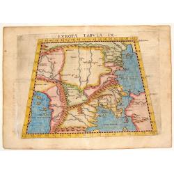
Europae Tabula IX.
One of the earliest maps of Turkey and Macedonia. From Girolamo Ruscelli's edition of "Ptolemy's Geographia". The map is drawn on the trapezoidal projection and...
Date: Venice, 1575
Selling price: ????
Please login to see price!
Sold in 2014
Asie.
Scarce wood-cut map of Asia. New Guinea has disappeared and Japan is represented as a turtle-shaped island. An important innovation is the appearance of the Straits of An...
Date: Paris, 1575
Selling price: ????
Please login to see price!
Sold in 2017
![[Kings of the Ottoman Empire].](/uploads/cache/14188-250x250.jpg)
[Kings of the Ottoman Empire].
On recto an early representation of the first Ottoman King of the dynasty (112x65 mm). On verso a portrait of Orchanes, second king (80x50 mm), and of Amurathes, third ki...
Date: Basle, about or after 1575
Selling price: ????
Please login to see price!
Sold in 2020
Ormus.
A scarce and early woodcut view of Hormuz, an island in the Strait of Hormuz, belonging to Iran. On the full text sheet. Based on the Hormuz view of Braun and Hogenberg. ...
Date: Paris, 1575
Selling price: ????
Please login to see price!
Sold in 2016
![Calechut Celeberrimum Indiae Emporium [on sheet with] Ormus [and] Canonor [and] S. Georgii Oppidum Mina.](/uploads/cache/33683-250x250.jpg)
Calechut Celeberrimum Indiae Emporium [on sheet with] Ormus [and] Canonor [and] S. Georgii Oppidum Mina.
Four very desirable and early town-plans of Kozhikode, Hormuz, Kannur and Almina. "KOZHIKODE (CALICUT) : "The city is viewed from the sea, just as it would hav...
Date: Cologne, (1572) 1577
Selling price: ????
Please login to see price!
Sold in 2017
![Anfa, quibusdam Anaffa [on sheet with] Azaamurum [and] Diu [and] Goa.](/uploads/cache/33685-250x250.jpg)
Anfa, quibusdam Anaffa [on sheet with] Azaamurum [and] Diu [and] Goa.
Four very desirable and early town-plans of Casablanca (Anfa) - Azemmour (Azamor) - Diu - Old Goa (Velha Goa) "CASABLANCA (ANFA) : "The engraving shows the rav...
Date: Cologne, (1572) 1577
Selling price: ????
Please login to see price!
Sold in 2020
![Calechut Celeberrimum Indiae Emporium [on sheet with] Ormus [and] Canonor [and] S. Georgii Oppidum Mina.](/uploads/cache/36842-250x250.jpg)
Calechut Celeberrimum Indiae Emporium [on sheet with] Ormus [and] Canonor [and] S. Georgii Oppidum Mina.
Four very desirable and early town-plan of Kozhikode, Hormuz, Kannur and Almina. "KOZHIKODE (CALICUT) : "The city is viewed from the sea, just as it would have ...
Date: Cologne, (1572) 1577
Selling price: ????
Please login to see price!
Sold
![Calechut Celeberrimum Indiae Emporium [on sheet with] Ormus [and] Canonor [and] S. Georgii Oppidum Mina.](/uploads/cache/41270-250x250.jpg)
Calechut Celeberrimum Indiae Emporium [on sheet with] Ormus [and] Canonor [and] S. Georgii Oppidum Mina.
Four very desirable and early town-plans of Kozhikode, Hormuz, Kannur and Almina. "KOZHIKODE (CALICUT) : "The city is viewed from the sea, just as it would hav...
Date: Cologne, (1572) 1577
Selling price: ????
Please login to see price!
Sold in 2018
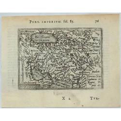
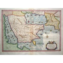
Percici Siuc Sophorum Regni Tipus.
This is a miniature map of Iran and Arabia in central Asia. Ortellius map taken from the first French edition of Le Miroir du Monde, published by Galle & Heyns in 157...
Date: Antwerp, 1577
Selling price: ????
Please login to see price!
Sold in 2021
![Calechut Celeberrimum Indiae Emporium [on sheet with] Ormus [and] Canonor [and] S. Georgii Oppidum Mina.](/uploads/cache/46221-250x250.jpg)
Calechut Celeberrimum Indiae Emporium [on sheet with] Ormus [and] Canonor [and] S. Georgii Oppidum Mina.
Four very desirable and early town-plan of Kozhikode, Hormuz, Kannur and Almina. "KOZHIKODE (CALICUT) : "The city is viewed from the sea, just as it would have...
Date: Cologne, (1572) 1577
Selling price: ????
Please login to see price!
Sold in 2022
Asiae novissima tabula.
Map of Asia, including the most western part of America from the extremely rare first edition. De Jode describes this map as new, as he extended the map westward from Ort...
Date: Antwerp 1578
Selling price: ????
Please login to see price!
Sold
Terrae Sanctae quae Promissionis terra, est Syriae pars,..
Map of Holy land from the extremely rare first edition.. This map shows the Mediterranean at the top while the entire lower right offers a detailed view of Jerusalem. Eng...
Date: Antwerp 1578
Selling price: ????
Please login to see price!
Sold
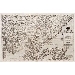
Tertiae Partis Asiae..
Map of India, Malaysia, China's south coast, Philippines, northern part of Sumatra, Borneo. From the extremely rare first edition.. Engraved by Joannes and Lucas van Deut...
Date: Antwerp 1578
Selling price: ????
Please login to see price!
Sold
Sumatra ein grosse insel..
Map of island of Taprobana, which was variously thought to be Ceylon or Sumatra. This map depicts Ceylon with the typical misconceptions of Ptolemy showing a small part o...
Date: Basle, 1578
Selling price: ????
Please login to see price!
Sold in 2009
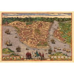
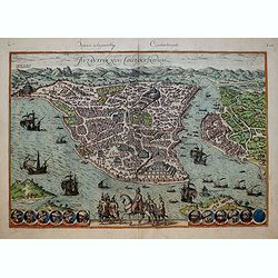
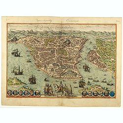
Constantinopel
Detailed bird's-eye view of the Golden Horn of Constantinople. The city plan depicts the markets, homes, palaces and churches, including the famous Hagia Sophia, shown pr...
Date: Basle, 1578
Selling price: ????
Please login to see price!
Sold in 2009
Das Heilig Judisch Land mit Ausztheilung der Zwolff Geschlechter.
Munster based this map of the Holy Land on maps by Mercator and Ziegler and filled it with numerous woodcut vignettes. The unusual orientation of the map places west at t...
Date: Basle 1578
Selling price: ????
Please login to see price!
Sold in 2009
Die heilige statt Jerusalem contrafehtet nach form und gestalt..
Bold woodcut view of Jerusalem from an edition of Munster's Cosmographia. Well-detailed birds-eye view from outside the walls with numerous buildings and temples named. O...
Date: Basle, 1578
Selling price: ????
Please login to see price!
Sold in 2009
Asiae Tab.VI.
Finely engraved, this classical map of the Arabia peninsula after Ptolemy from the renowned Gerhard Mercator. The map shows the Gulf of Persia in an almost rectangular f...
Date: 1578
Selling price: ????
Please login to see price!
Sold in 2015
Byzantium, Nunc Constantinopolis..
One of the finest and most sought-after views of Istanbul. Viewed from the village of Scutari, the City is shown with all its fortifications, the original Genoese distric...
Date: Cologne, 1578
Selling price: ????
Please login to see price!
Sold in 2017
Byzantium, Nunc Constantinopolis..
One of the finest and most sought-after views of Istanbul. Viewed from the village of Scutari, the City is shown with all its fortifications, the original Genoese distric...
Date: Cologne, 1578
Selling price: ????
Please login to see price!
Sold in 2020
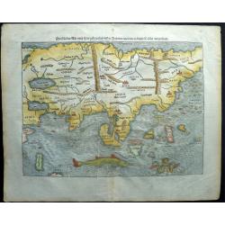
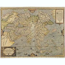
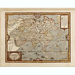
Asia, die Länder Asie nach ihrer gelegenheit biss in Indiam werden in dieser Tafeln verzeichnet.
This is one of the earliest maps of the whole continent of Asia, based on the recent geographical discoveries by Portuguese navigators. The outline of the Asian mainland ...
Date: Basel, 1578
Selling price: ????
Please login to see price!
Sold in 2018
Primae Partis Asiae.
The Very Rare First State. Turkey/ Holy Land/ Iran/ Iraq/ Arabia/ Afganistan.
Date: Antwerp, 1578
Selling price: ????
Please login to see price!
Sold
Holy Land. Die Tafel gibt ein klein anzeigung...
Early, attractive woodcut map of the Holy Land with Cyprus. On the full page. From the German edition of Sebastian Münster's Cosmography, titled Cosmographey oder beschr...
Date: Basel, 1578
Selling price: ????
Please login to see price!
Sold in 2020