Browse Listings in America

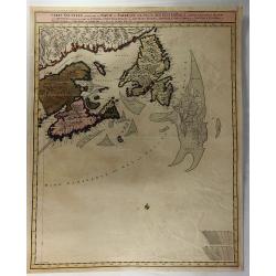
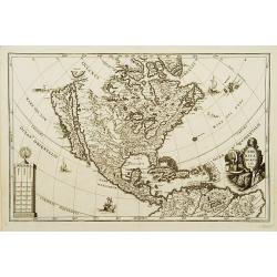
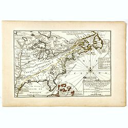
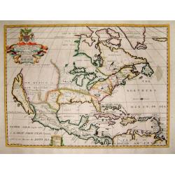
Belgii novi, angliae novae, et partis Virginiae . . .
This example is state 3 of the original Janssonius plate, printed after Schenk acquired the plates at public auction in 1694 from the heirs of Jansson van Waesberge. The ...
Date: Amsterdam, 1694
Selling price: ????
Please login to see price!
Sold in 2025
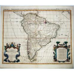
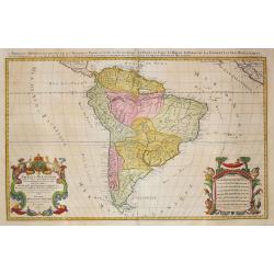
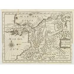
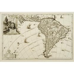
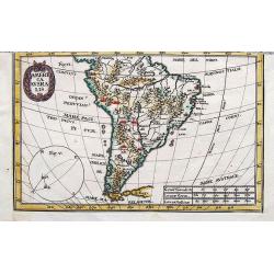
L'Amerique Meridionale Divisee en ses Principales Parties. . .
A handsome large-format map of South America by Jaillot, based upon the earlier maps of Nicholas Sanson. From: 'Atlas Royal', Amsterdam, 1694.Jaillot’s map is well-fram...
Date: Amsterdam, 1694
Selling price: ????
Please login to see price!
Sold in 2021
![Straet Davis en Hudson [Portrait of two locals]](/uploads/cache/06034-250x250.jpg)
Straet Davis en Hudson [Portrait of two locals]
Rare print of two locals of Canada, probably from Allard's Orbis Habitabilis Oppida et Vestitus.
Date: Amsterdam 1695
Selling price: ????
Please login to see price!
Sold
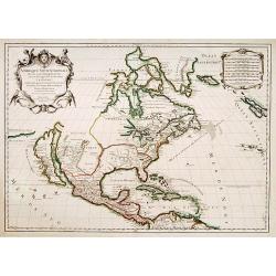
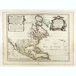
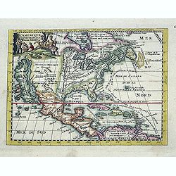
Amérique septentrionale divisée en ses principales parties..
Engraved by Cordier. Spectacular example of Jaillot's map of North America, showing California as an Island, based upon Sanson's landmark map of 1656. This map shows the ...
Date: Paris, 1695
Selling price: ????
Please login to see price!
Sold
America meridionale Auttore Il P.M. Coronelli M.C. Cosmografo della Serenissima Repub. Di Venetia..
Matching set of 2 attractive large folio maps depicting all of South America in the grand Coronelli style. Splendid large ornate cartouche with Coronelli's normal flouris...
Date: Venice 1696
Selling price: ????
Please login to see price!
Sold
Amerique septentrionale / divisee en ses principales parties. Paris, 1695.
Alexis-Hubert Jaillot (1632-1712), French cartographer. He joined the Sanson heirs and redrew Nicolas Sanson's maps on a larger scale. 'Atlas Nouveau' (1674), sea-atlas '...
Date: Amsterdam, 1696
Selling price: ????
Please login to see price!
Sold
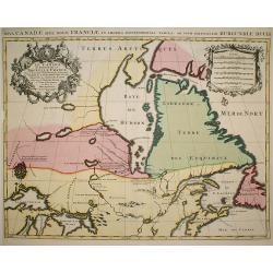
Le Canada ou Partie de la Nouvelle France..
A derivative of the 1685 map with a number of alterations including posts established by the French to prevent the Indians trading with the English in the Hudson's Bay an...
Date: Paris, 1696
Selling price: ????
Please login to see price!
Sold in 2009
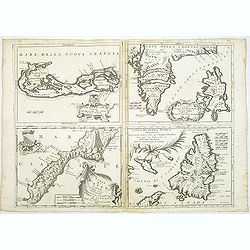
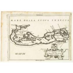
Le Bermude / Frislanda / Isola di Mayen / Isola di Terra Nuova.
Four maps printed on one large sheet, each from a separate copper plate. The remarkable Vincenzo Coronelli (1650-1718), encyclopaedist, geographer, inventor and Doctor of...
Date: Venice, 1696
Selling price: ????
Please login to see price!
Sold
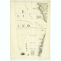
(Globe gore) Della citta di Chiloe. . .
Globe segment published in 1696 as part of the atlas entitled "Libri dei Globi". The page contains part of the west coast of Chili and Peru. This atlas containe...
Date: Venice, 1696
Selling price: ????
Please login to see price!
Sold in 2012
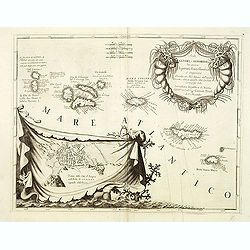
Isole Azzori, o Azzoridi. . .
A beautiful and highly decorative map of the Azores Islands. With large title cartouche in the upper right corner decorated with coral, fish, seaweeds and pearl chains.In...
Date: Venice, ca. 1696
Selling price: ????
Please login to see price!
Sold in 2014
Le Bermude, Dedicate All'Illusstrissimo Sig:r Abbate Isidoro Bernardi.
Fine map of Bermuda with the title cartouche incorporating a the cardinal’s arms beneath, this map occurred in an atlas called ‘Corso Geographico Universale’.The re...
Date: Venice, 1696
Selling price: ????
Please login to see price!
Sold in 2014
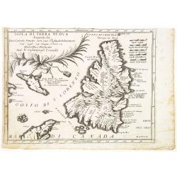
Isola Di Terra Nuova Scoperta da Gio: Cabota Veneto con suo Figliuso Sebastiano l'an 1596 24 Giugno a hore 12 . . .
A fine map of Newfoundland reduced from Coronelli's larger map of the Maritimes.The title is referencing to the discovery of the island by the Venetian explorer Giovanni ...
Date: Venice, 1696
Selling price: ????
Please login to see price!
Sold in 2014
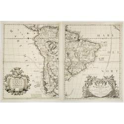
Amerique meridionale divisee en ses principales.
An attractive large-format map of the South American continent, embellished with two large cartouches. Newly engraved for the counterfeited edition of the 'Atlas Nouveau'...
Date: Amsterdam, 1696
Selling price: ????
Please login to see price!
Sold in 2022
L'Amérique septentrionale et les terres polaires arctique (sic) / dressée par N. de Fer.
An interesting small map of North America by Nicolas de Fer. From his rare "Petit et Nouveau Atlas". The first edition was published in 1697 and was republished...
Date: Paris,1697
Selling price: ????
Please login to see price!
Sold in 2016
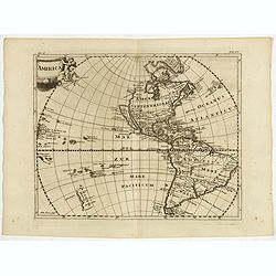
America.
Interesting map of America showing California as an island and completely omitting the Great Lakes. From Philipp Clüver's famous Introductionis in Universam geographicam...
Date: Amsterdam, 1697
Selling price: ????
Please login to see price!
Sold in 2017
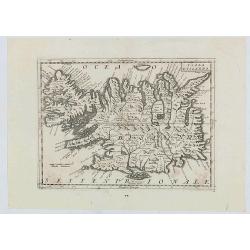
Isola d'Islanda
The map is a reduced copy of Joris Carolus', but the forms of the names and other features suggest that the model was the version by Johannes Janssonius rather than that ...
Date: Venice, 1697
Selling price: ????
Please login to see price!
Sold in 2020
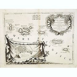
Isole Azzori, o Azzoridi. . .
A beautiful and highly decorative map of the Azores Islands. With large title cartouche in the upper right corner decorated with coral, fish, seaweeds and pearl chains.In...
Date: Venice, 1698
Selling price: ????
Please login to see price!
Sold in 2013
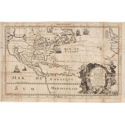
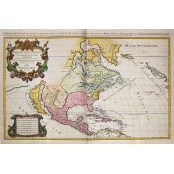
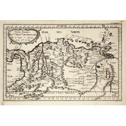
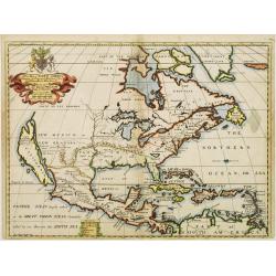
Carte d'un Nouveau Monde, entre le Nouveau Mexique et la Mer Glaciale ...
Map of America from Nouveau Voyage d'un Pays plus grand que l'Europe ... by R. P. Louis Hennepin, published in Utrecht in 1698.Based on his 1683 map Carte de la Nouvelle ...
Date: Utrecht, 1698
Selling price: ????
Please login to see price!
Sold in 2014
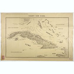
Kaart van Cuba. Bijvoegsel behoorende bij het 2e blad van de nieuwe Rotterdamsche Courant van Vrijdag 6 Mei 1898.
Lithographed map of Cuba, including southern tip of Florida with the Keys and the Bahama Islands. Several folds as issued, some underlaid with archival tape. Published as...
Date: Rotterdam, 1698
Selling price: ????
Please login to see price!
Sold in 2017
Nouveau Voyage d'un Pais Plus Grand que l'Europe.
FIRST EDITION OF THE BOOK. This edition of Hennepin's writings, a continuation of his Nouveau voyage of the previous year, comprises materials about La Salle taken from C...
Date: Utrecht, [E. Voskuyl for] Antoine Schouten, 1698
Selling price: ????
Please login to see price!
Sold
Carte D'un Nouveau Monde, entre le Nouveau Mexique, et la Mer Glacialle Novellement decouvert par le R.P. Louis Hennepin...
Extremely rare second edition of Louis de Hennepin’s map of North America, which incorporates many of the discoveries omitted by Hennepin in the first edition of his ma...
Date: Paris, 1698
Selling price: ????
Please login to see price!
Sold in 2021
Atlantis Insula.
Third state (of five) of the unusual map that purports to show the earth about 200,000 years ago before its settlement by humans. The god Neptune had divided up the land ...
Date: Paris 1699
Selling price: ????
Please login to see price!
Sold
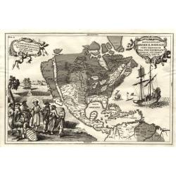
Repraesentatio Americae Borealis...
An interesting religious map of North America, showing the Catholic regions illuminated and the Protestant and still uncolonized lands swathed in darkness. California is ...
Date: Munich 1699
Selling price: ????
Please login to see price!
Sold
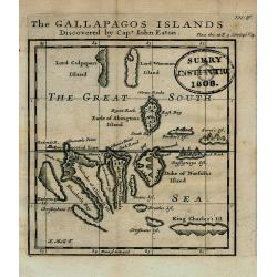
The GALLAPAGOS ISLANDS Discovered by Capt. John Eaton
Important map of the Galapagos Islands in the Pacific Ocean, now belonging to Ecuador. Discovered first by Spanish sailors, then a hideaway for Pirates, they later came u...
Date: London, 1699
Selling price: ????
Please login to see price!
Sold in 2008
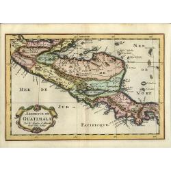
Audience de Mexico.
From a pocket atlas called: Description de tout l'Univers, published by F.Halma. Engraved by A. de Winter."
Date: Amsterdam, 1700
Selling price: ????
Please login to see price!
Sold
A new map of.. Plantations of the English in America..
"A boldly engraved large-scale map of the Carolinas, Nova Scotia, Bermuda, Barbados and Jamaica appear as large insets on this interesting uncommon and attractive ma...
Date: London 1700
Selling price: ????
Please login to see price!
Sold
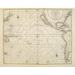
Mer de Sud ou Pacifique contenant l'Isle de Californe. . .
Intriguing map of the Pacific copied from important manuscript maps collected by the Portuguese crown and secreted away in Portuguese archives. Showing California with in...
Date: Amsterdam, 1700
Selling price: ????
Please login to see price!
Sold in 2016
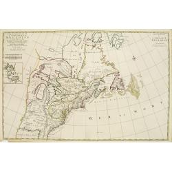
Carte Nouvelle de L'Amerique Angloise Contenant La Virginie, Mary-Land, Caroline, Pensylvania, Nouvelle Jorck, N. Jarsey, N. France..
A unique map of eastern North America with oversized Great Lakes. Pennsylvania includes both Delaware and eastern Maryland and almost bisects New York. Virginia includes ...
Date: Amsterdam c. 1700
Selling price: ????
Please login to see price!
Sold
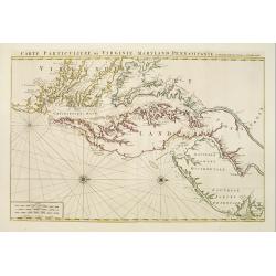
Carte Particuliere de Virginie, Maryland, Pennsilvanie, La Nouvelle Jarsey. Orient et Occidentale.
Large scale, decorative map centered on Maryland and the Chesapeake Bay. Shown is an area from Staten Island in New York southward to Carratuck Inlet in North Carolina wi...
Date: Amsterdam c. 1700
Selling price: ????
Please login to see price!
Sold
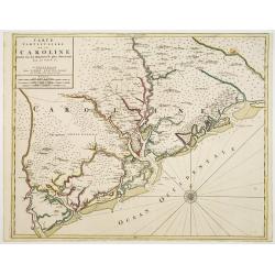
Carte Particuliere de la Caroline Dresse Sur les Memoires le plus Nouveaux.
Large, decorative map of today South Carolina centered on Charleston. The area represented extends from the South Edisto River northward to the Santee River. Illustrated ...
Date: Amsterdam 1700
Selling price: ????
Please login to see price!
Sold
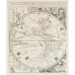
Title in Greek (Sub-title: Index Geographicus tum vete..)
This sheet covers the western hemisphere, with California as an island, and has Greek lettering throughout. As stated in the long Greek title and Latin sub-title it is th...
Date: Padua, 1700
Selling price: ????
Please login to see price!
Sold in 2010
Peru ou Perou.
Charming map of Peru. Including some of the territory of today Equador on the north and extending southwards as far as the Atacama desert in Chile. Decorated with a large...
Date: Amsterdam 1700
Selling price: ????
Please login to see price!
Sold
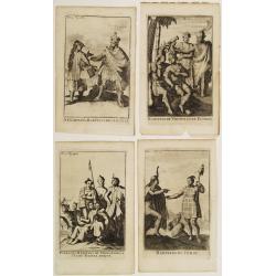
Four engravings by M. Duplessis.
4 decorative engravings representing native American people.Mexiquains. Habitans des Antiles.Habitans de Virginie et de Floride.Habitans du Perou.Patagons. Habitans du Ch...
Date: Amsterdam 1700
Selling price: ????
Please login to see price!
Sold
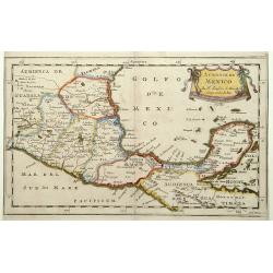
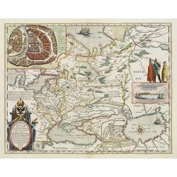
Audience de Guatimala
Nice map that illustrates the region from the Yucatan to the Gulf of Panama. It is nicely detailed, although much of the topography is still incorrect. Lago de Nicaragua ...
Date: Amsterdam, 1700
Selling price: ????
Please login to see price!
Sold in 2008
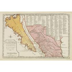
Cette Carte de Californie et du Nouveau Mexique ?
A most important map, identifying by numerical code some 314 places in New Mexico, and showing in detail California as an island, although based on Sanson's monumental ma...
Date: Paris, 1700
Selling price: ????
Please login to see price!
Sold in 2009
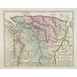
Nieuwe kaart van Suriname vertonende de stromen en land-streken van Suriname, Comowini, Cottica en Marawini, gelegen in Zuid America op de kusten van Caribana. . .
Decorative full color example of Ottens map of Suriname. Detailed map of the northeast part of Suriname between Paramaribo, with fort Zeelandia, and Mana. Along the Surin...
Date: Amsterdam, ca. 1700
Selling price: ????
Please login to see price!
Sold
Terre Ferme, Nouveau Royaume de Grenade ?
Fine map of Colombia, Venezuela and the islands of Curaçua, Aruba, Bonaire, etc ... Prepared by N. Sanson. Engraved by A. de Winter.
Date: Amsterdam, 1700
Selling price: ????
Please login to see price!
Sold in 2009
Extrema Americae Versus Boream, ubi Terra Nova Nova Francia, Adiacentiaq.
Rare issue by Pierre Mortier, identical to 1662's map by J. Blaeu. Later reissued by J. Covens also.The map is in a strictly contemporary coloring and of the highest leve...
Date: Amsterdam, c.1700
Selling price: ????
Please login to see price!
Sold in 2014

Audience de Mexico.
From a pocket atlas called "Description de tout l'Univers" published by F. Halma. Engraved by A. de Winter.
Date: Amsterdam, 1700
Selling price: ????
Please login to see price!
Sold in 2011
Terre Ferme et Nouv. Royaume de Grenade et Popaian.
Charming and uncommon map of today territory of Colombia. Decorated with a compass rose and title cartouche.
Date: Amsterdam, 1700
Selling price: ????
Please login to see price!
Sold in 2015
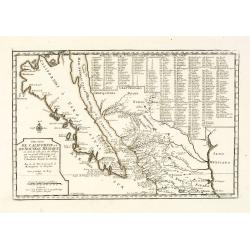
Cette Carte de Californie et du Nouveau Mexique.
A most important map, identifying by numerical code some 314 places in New Mexico, and showing in detail California as an island, although based on Sanson's monumental ma...
Date: Paris, 1700
Selling price: ????
Please login to see price!
Sold in 2013
Partie Orientale de l'Amérique Angloise.
This is the eastern half of Mortier's two-sheet map of the eastern United States and Canada: "Carte Nouvelle de l'Amerique Angloise. This sheet, focusing almost all ...
Date: Amsterdam, 1700
Selling price: ????
Please login to see price!
Sold in 2016
Recentissima Novi Orbis sive Americae Septentrionalis et Meridionalis Tabula ex officina Caroli Allard . . .
Map of estern hemisphere by Carol Allard (1614-1709); drawn by Ph.Tideman, engraved G. van Gouwen. from: Atlas Minor', published Amsterdam, c1700. 3rd state with climates...
Date: Amsterdam, ca. 1700
Selling price: ????
Please login to see price!
Sold in 2016
Carte Nouvelle Contenant la Partie D'Amerique la Plus Septentrionale ...
Fine example of the eastern part of Visscher's 2-sheet map of the Northeastern part of North America, first published in 1696. The map extends from Nova Scotia and Acad...
Date: Amsterdam, c1700
Selling price: ????
Please login to see price!
Sold in 2018
L'Amerique Septentrionale dressée sur les Observations de Mrs de l'Academie Royale des Sciences . . .
Rare third state of "L’Amerique Septentrionale. Chez l’Auteur sur le Quai de l’Horloge a la Cour. de Diamans avec Privilege du Roy pour 20 ans, 1700". &qu...
Date: Paris, 1700
Selling price: ????
Please login to see price!
Sold in 2018
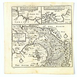
A Map of the Isthmus of Darien, & Bay of Panama.
A map of the Isthmus of Darien and Bay of Panama, with the twin insets of the North Sea Coast & the South Sea Coasts at the top. From A New Voyage around the World', ...
Date: London, ca 1700
Selling price: ????
Please login to see price!
Sold in 2019
![Cette Carte DE CALIFORNIE et DU NOUVEAU MEXIQUE.[Rare 1st edition!]](/uploads/cache/83264-250x250.jpg)
Cette Carte DE CALIFORNIE et DU NOUVEAU MEXIQUE.[Rare 1st edition!]
Rare and important map of California ,New Mexico and New Spain, showing in detail California as an island [San Francisco, San Diego and Mendocino are mentioned among many...
Date: Paris 1700
Selling price: ????
Please login to see price!
Sold in 2021
Carver's new map of North America. . .
6 maps on a sheet Carver's map of North America, among other maps of Strait Anian.
Date: England, ca. 1700
Selling price: ????
Please login to see price!
Sold in 2020
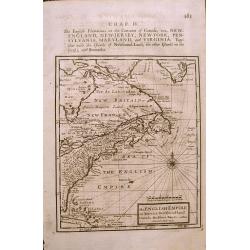
The ENGLISH EMPIRE in America.
Early English map of the British Colonies in North America from Herman Moll's 'A System of Geography' published in 1701. Compass Rose and rhumb lines with text on the rev...
Date: London, 1701
Selling price: ????
Please login to see price!
Sold in 2015
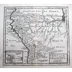
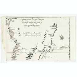
Peru and the Amazones Country.
Detailed copper engraved map showing parts of todays Peru, Ecuador, Bolivia, Brazil, Columbia, Chile and Argentina. From Quito until the mouth of the Amazonas. Includes a...
Date: London, ca. 1701
Selling price: ????
Please login to see price!
Sold in 2018
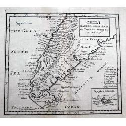
Chili Magellans-Land, and Terra del Fuego &c.
A detailed copper engraved map south of Paraguay with Chile, Argentina, Tierra del Fuego, Le Maire Strait, and a small tip of the Falkland Islands. Includes a curious 'Da...
Date: London, ca 1701
Selling price: ????
Please login to see price!
Sold in 2018
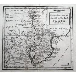
The Great Province of Rio de la Plata.
A detailed copper engraved map of parts of Brazil, Paraguay and Uruguay until Buenos Aires. Includes a curious Lake of Xarayes and the fictional Saxemberg Island.
Date: London, ca 1701
Selling price: ????
Please login to see price!
Sold in 2018
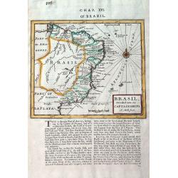
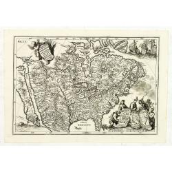
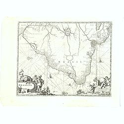
Brasil, divided into its Captainships.
Important map of Brazil when it was a Portuguese colony. It depicts the various captainships including Para, Maragnan, Siara, Rio Grande, Paraiba, Tamaraca, Pernambuco, S...
Date: London, 1701
Selling price: ????
Please login to see price!
Sold in 2019
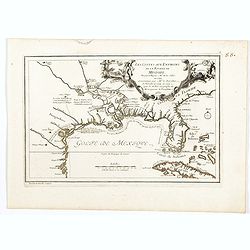
Les Costes aux Environs de la Riviere de Misisipi.
An historically important map of Florida and the Gulf Coast showing especially the estuary of the Mississippi in some detail, more or less correctly located.The locations...
Date: Paris, 1701
Selling price: ????
Please login to see price!
Sold in 2022
Mauritius.
Uncommom map of the southern most tip of Tiera del Fuego. From "Recueil des voiages qui ont servi a l'etablissement et aux progres de la Compagnie des Indes Oriental...
Date: Amsterdam, 1702
Selling price: ????
Please login to see price!
Sold
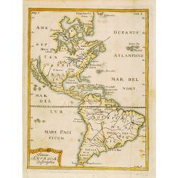
Totius Americae Descriptio.
Rare map of America with California as an island on Briggs model and lacking detail to north. From Kort Beskrifning Om Provincien Nya Swerige uti AMERICA, som nu fortjden...
Date: Stockholm 1702
Selling price: ????
Please login to see price!
Sold
America borealis 1699.
A map from the series of maps by the Jesuit mathematician. One of the two maps of North America from the series of about six of North America, produced by Scherer to show...
Date: Munich c.1702
Selling price: ????
Please login to see price!
Sold
America australis dei parae Multas Sacras Aedes..
A map from the series of maps by the Jesuit mathematician. A general map of south America, produced by Scherer to show the spread of Catholicism in the continent. This de...
Date: Munich c.1702
Selling price: ????
Please login to see price!
Sold
Delineatio Nova Et Vera Partis Australis Novi Mexici.
Attractive map of the Southern Portion of Baja California and contiguous Mexico, based in part on Scherer's correspondence with Fra. Eusebio Kino, the Jesuit Missionary c...
Date: Munich c.1702
Selling price: ????
Please login to see price!
Sold
Nova Svecia hodie dicta Pensylvania.
Very rare map shows the location of Swedish settlements on the Delaware River.Prepared by Peter Lindström in 1655, who made a map titled Nova Svecia, anno 1654 och 1655,...
Date: Stockholm 1702
Selling price: ????
Please login to see price!
Sold
Pelineatis anarium Peru cujus Metropolis Lima : In qua vicarus Regis, Archie piscopusque . . . .
Uncommon map of the central part of South America with Peru, Brasil. Only coastal names.From a travel book describing the early Dutch voyages by René Augustin Constantin...
Date: Amsterdam, E. Rogers, 1702
Selling price: ????
Please login to see price!
Sold in 2016
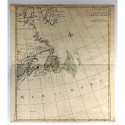
Provinciae Borealis Americae non ita Pridem Detectae aut Magis ab Europaeis Excultae.
This captivating map of North America features a huge island of California, an oversized depiction of the Great Lakes, and a misplaced Mississippi River delta. The interi...
Date: Munich, 1702
Selling price: ????
Please login to see price!
Sold in 2012
L\'Amerique septentrionale. Noord America.
Map of North and Central America showing California as an island with indented coastline, and with place names R'Estiete, C.Blanco, P.de Carinde, Canal de S. Barbe, I. de...
Date: Amsterdam, 1702
Selling price: ????
Please login to see price!
Sold in 2013
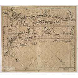
Pas-Kaart Vande Zee Kusten van Niew Nederland Anders Genaamt Niew York. . .
The first separate map of the Hudson River Valley, and the second printed of New York, Long Island and the southern New England coast. Based on original Dutch surveys ma...
Date: Amsterdam, 1682 - ca. 1702
Selling price: ????
Please login to see price!
Sold in 2013
Le Canada, ou Nouvelle France la Florida, la Virginie, Pensilvanie . . .
First edition. This fine map is showing the east coast of the United States from the Caribbean up to Newfoundland, with the western border just beyond the Mississippi.The...
Date: Paris, 1702
Selling price: ????
Please login to see price!
Sold in 2016
America Ausralis.
A charming and boldly engraved map of South America. This is the bottom part of a map of the Americas by Scherer. With major lakes, rivers and mountains shown, as well as...
Date: Munich, 1702
Selling price: ????
Please login to see price!
Sold in 2017
![Le Vieux Mexique ou NOUVELLE ESPAGNE avec les costes DE LA FLORIDE.[1st edition]](/uploads/cache/83258-250x250.jpg)
Le Vieux Mexique ou NOUVELLE ESPAGNE avec les costes DE LA FLORIDE.[1st edition]
The first edition of this interesting regional map of Florida, Texas, the Gulf Coast, the Southwest, Mexico and Central America, from the first edition of De Fer's Atlas ...
Date: Paris, 1702
Selling price: ????
Please login to see price!
Sold in 2020
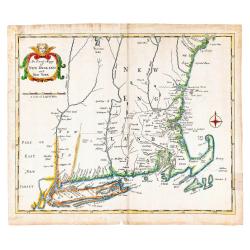
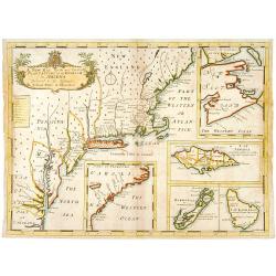
An Exact Mapp of New England and New York.
Recognized as the first 18th-century map of New England (Schwartz & Ehrenberg), this map was used to illustrate Cotton Mather's famous history of the Bay Colony, &quo...
Date: London: Printed for Thomas Parkhurst, 1702
Selling price: ????
Please login to see price!
Sold in 2023
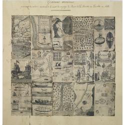
A compilation of 16 engravings taken from : Nouveaux Voyages de Mr. Le Baron de Lahontan, dans l'Amerique Septentrionale . . .
16 plates and maps with a title in manuscript in upper margin. The plates are quite detailed, if speculative, depicting Indians in many aspects, their clothing, accouterm...
Date: Paris, Freres l'Honore, 1703
Selling price: ????
Please login to see price!
Sold in 2012
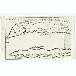
Porto il Desire.
Simplified bird's-eye view of Port Desire or Puerto Deseado in present-day Argentina.From volume two of the French reissue of the account of early Dutch voyages. The Fren...
Date: Amsterdam, E. Rogers, 1703
Selling price: ????
Please login to see price!
Sold in 2013
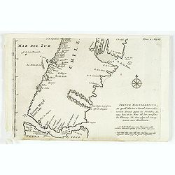
Fretum Magellanicum in quod Olivier a Noord Generalis navium. . .
Map of the southern tip of South America including parts of Chile, Argentina, and Tierra del Fuego. Cartographic elements include scales of German and Spanish miles, comp...
Date: Amsterdam, E. Roger, 1703
Selling price: ????
Please login to see price!
Sold in 2012
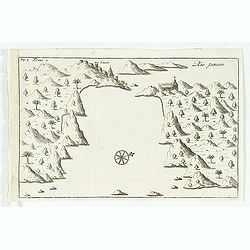
Isle du Prince.
Simplified bird's-eye view of "Isle du Prince" in present-day Argentina.From volume two of the French reissue of the account of early Dutch voyages. The French ...
Date: Amsterdam, E. Roger, 1703
Selling price: ????
Please login to see price!
Sold in 2013
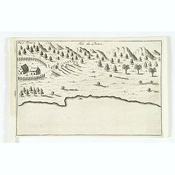
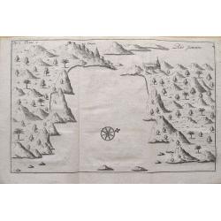
Rio Janeiro.
Simplified bird's-eye view of São Sebastião do Rio de Janeiro and Guanabara Bay, Brazil. Includes compass rose, church, and settlement.From volume two of the French rei...
Date: Amsterdam, E. Roger, 1703
Selling price: ????
Please login to see price!
Sold in 2012
Rio Janeiro.
Scarce map of the Guanabara Bay with Rio de Janeiro, from Constantin Renneville's "Recueil des voyages qui ont servi a l'etablissement et aux progres de la Compagnie...
Date: Amsterdam, 1703
Selling price: ????
Please login to see price!
Sold in 2015
Brasilia.
A very fine and decorative map of Brazil. From the book "A Collection of Voyages and Travels" by Churchill, the map came from the section containing a descripti...
Date: London, Printed for A. and J. Churchill, 1703
Selling price: ????
Please login to see price!
Sold in 2017
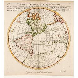
Hemisphere Superieur du Globe Terrestre..
Rare map of Western Hemisphere shown in reverse, but text printed normally. World from internal viewpoint. California with indented northern coast. Terre de Jesso to Nort...
Date: Paris 1704
Selling price: ????
Please login to see price!
Sold
A New Map of North America Shewing its Principal Divisions, Chief Cities, Townes, Rivers, Mountains & c.
A boldly engraved map of North America, showing California as an island. This is a state 4. California as New Abion discovered by Sir Francis Drake Anno 1577 . Traci now ...
Date: London, 1704
Selling price: ????
Please login to see price!
Sold in 2018
A New Map of North America
Title: 'A New Map of North America Shewing its Principal Divisions, Chief Cities, Townes, Rivers, Mountains & c.'. A rare and interesting map of North America. Alth...
Date: London, 1704
Selling price: ????
Please login to see price!
Sold
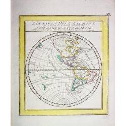
Der neuen West Begriff...
Scarce German miniature map of the Western Hemisphere showing California as an Island, a partial coast of New Zealand and a misshaped South America. The western coast of ...
Date: Augsburg 1704
Selling price: ????
Please login to see price!
Sold
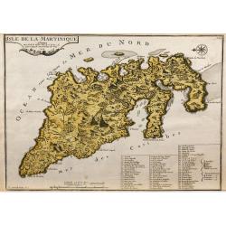
L'Isle de la Martinique.
Map of the island of Martinique, engraved by F.Starckman, from De Fer's Atlas Curieux.
Date: Paris, 1704
Selling price: ????
Please login to see price!
Sold in 2009