Subscribe to be notified if similar examples become available.
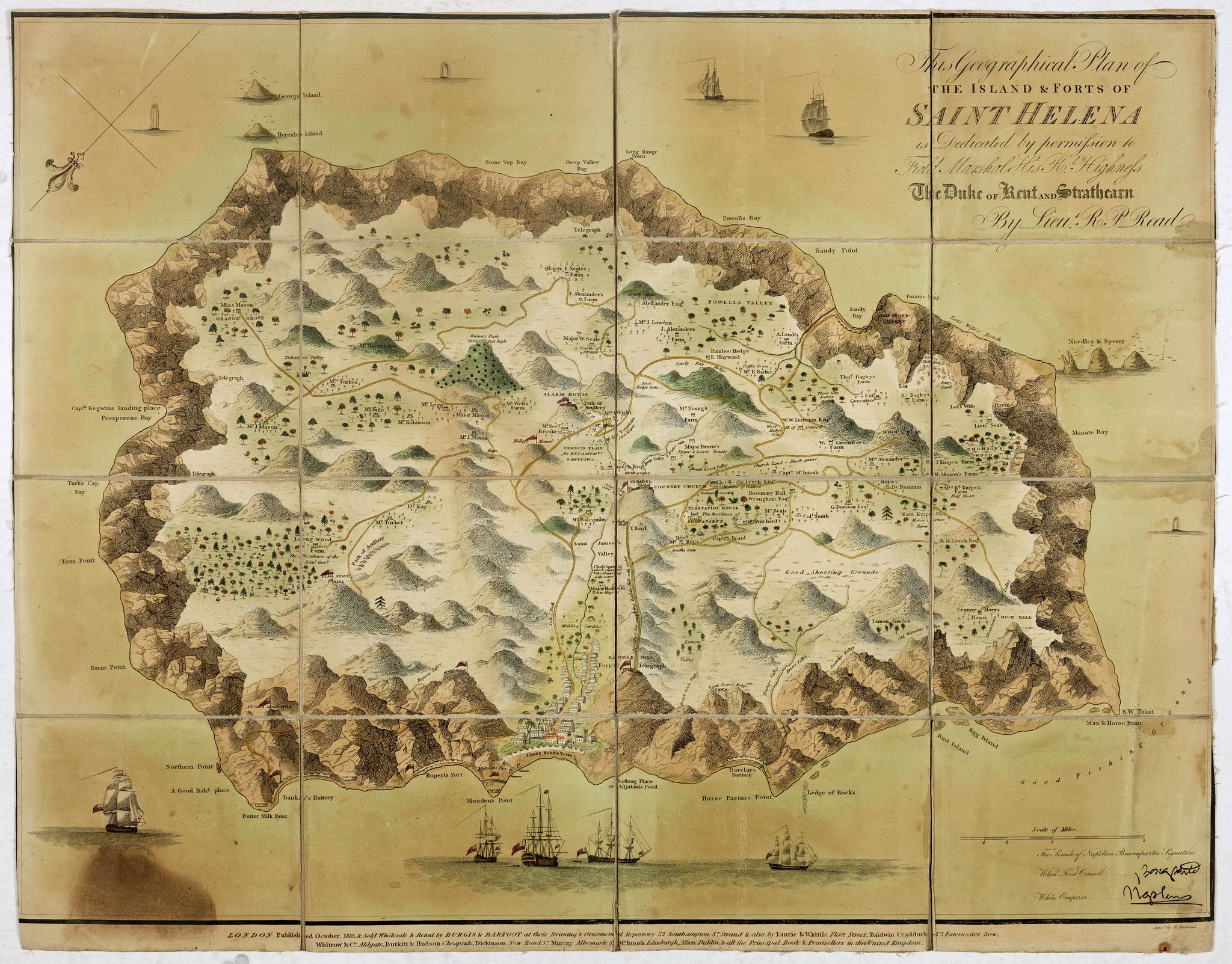
This Geographical Plan of the Island & Forts of St Helena is Dedicated by permission to Field Marshal His Ro.l Highness The Duke of Kent and Strathearn By Lieu.t R.P. Read. |
||||||||||||||||||||
|
||||||||||||||||||||
|
|
||||||||||||||||||||
|
Selling price: $ Please login to see price!
Sold in 2021 Missed this item! Add your name to our mailing list and be the first to get notified about our newly added listings. . |
My Collection +
Add this or any of your favorite items in one place. If you want to save the items permanently, you have to sign in or create an account first. |
|||||||||||||||||||
Description
FIRST EDITION. A map of the island of St Helena, decorated with trees, ships, cannons, residences, and even whales (perhaps sperm whales) firing powerful jets of water from their blowholes, lending an illustrative air to the island's geographical representation.
Each country property lists its owner, whilst the Helenian “landmarks”, such as telegraphs and the citadel, are also depicted, thus adding some supplementary but precious historical information to the document.
This South Atlantic island chosen to house Napoleon during his second exile because of the ring of high cliffs that would make escape a virtual impossibility.
For the first two months he lived in a pavilion on 'The Briars' estate (almost the centre of the map).
He was then moved to Longwood House. The poor state of repair of Longwood, situated on a damp and windswept part of the island, is reported to have shortened the former emperor's life.
The rare first edition with "PLANTATION HOUSE The Residence of BUONAPARTE" erroneously marked as residence of Napoleon Bonaparte and "Longwood farm The Residence of the Lieu.t Gov."
In the lower right corner of the map there are facsimiles of Napoleon's signature, first when First Consul, and another when Emperor. Robert Kirkwood (December 8, 1774 – November 14, 1818) was a Scottish engraver active in Edinburgh during the late 18th and early 19th century. (B.Worms, British Map Engravers p. 377.)
Three published editions in three years – plus a subsequent fourth edition, printed in 1841 – suggest that the map was successful, commercially speaking.
- The first edition was published in October 1815 by London's Burgis & Barfoot (32 Southampton Street, The Strand). This version is the rarest – and thus most sought-after – because it lists "Buonaparte's" residence as Plantation House, which subsequently went on to become the governor's “palace”, occupied by Hudson Lowe.
- The second edition, also dated October 1815, rectified some labelling mistakes: Longwood, naturally, became Napoleon's home, Mr Balcombe's house – The Briars – was changed to "Buonaparte's first residence”, and Plantation House was captioned “Residence of Governor". The precise date of this edition is uncertain: either it is correctly dated and it was a matter of a few days or weeks between the two print runs, or the date is out by a couple of months, but the publisher did not see fit (or simply forgot) to change the print date.
- The third edition – which contained no changes – went on sale on 4 June, 1817, and was produced by a different London printing and publishing firm (this time J. M. Rippin, n° 21 Theobald's Road).
- The fourth edition – from 1841 – was released once again by Burgis & Barfoot. This edition was timed to coincide with another Napoleonic event: the return of the emperor's remains to Paris – the "Retour des Cendres" – which took place in 1840.
FAQ - Guarantee - Shipping
Buying in the BuyNow Gallery
This item is available for immediate purchase when a "Add to Cart" or "Inquire Now" button is shown.
Items are sold in the EU margin scheme
Payments are accepted in Euros or US Dollars.
Authenticity Guarantee
 We provide professional descriptions, condition report (based on 45 years experience in the map business)
Paulus Swaen warrants the authenticity of our items and a certificate of authenticity is provided for each acquired lot.
Condition and Coloring
We indicate the condition of each item and use our unnique HiBCoR grading system in which four key items determine a map's value: Historical Importance, Beauty, Condition/Coloring and Rarity.
Color Key
We offer many maps in their original black and white condition. We do not systematically color-up maps to make them more sellable to the general public or buyer.
Copper engraved or wood block maps are always hand colored. Maps were initially colored for aesthetic reasons and to improve readability. Nowadays, it is becoming a challenge to find maps in their original colors and are therefor more valuable.
We use the following color keys in our catalog:
Original colors; mean that the colors have been applied around the time the map was issued.
Original o/l colors; means the map has only the borders colored at the time of publication.
Colored; If the colors are applied recently or at the end of the 20th century.
Read more about coloring of maps [+]
Shipping fee
A flat shipping fee of $ 30 is added to each shipment by DHL within Europe and North America. This covers : International Priority shipping, Packing and Insurance (up to the invoice amount).
Shipments to Asia are $ 40 and rest of the world $50
We charge only one shipping fee when you have been successful on multiple items or when you want to combine gallery and auction purchases.
Read more about invoicing and shipping
FAQ
Please have a look for more information about buying in the BuyNow gallery
Many answers are likely to find in the general help section.
My Collection+
![]()
With My Collection+ you can collect all your favorite items in one place. It is free, and anyone can create his or her virtual collection.
Unless you are logged in, the item is only saved for this session. You have to be registed and logged-in if you want to save this item permanently to My Collection+.
Read More[+]
Register here, it is free and you do not need a credit card.
Add this item to
My Collection+
or click the following link to see My Collection+.
| Digital Image Download | |
|
Paulus Swaen maintains an archive of most of our high-resolution rare maps, prints, posters and medieval manuscript scans. We make them freely available for download and study. Read more about free image download |
Click the image for a free small image download. |
In accordance with the EU Consumer Rights Directive and habitually reside in the European Union you have the right to cancel the contract for the purchase of a lot, without giving any reason.
The cancellation period will expire 14 calendar days from the day after the date on which you or a third party (other than the carrier and indicated by you) acquires, physical possession of the lot. To exercise the right to cancel you must inform Paulus Swaen Inc, of your decision to cancel this contract by a clear statement (e.g. a letter sent by post, or e-mail.
To meet the cancellation deadline, it is sufficient for you to send your communication concerning your exercise of the right to cancel before the cancellation period has expired.
