Browse Listings in Europe
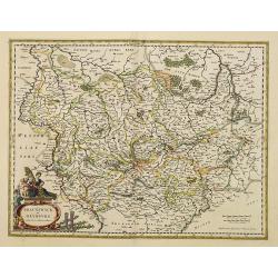
Bravnswyck et Meydburg. . .
As Willem Blaeu died in 1638 most of his maps are actually published by his son Joan. This maps carries his (engraved) signature and was actually published in volume II o...
Date: Amsterdam, 1638
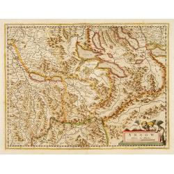
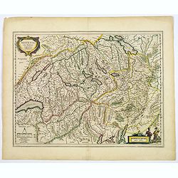
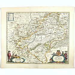
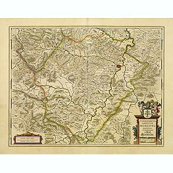
Argow .
Centered on the Bernese and Lucerne. Including the towns of Lucerne, Bern and Thuner- and Lucerner See. Prepared by Gerard Mercator.
Date: Amsterdam, 1639
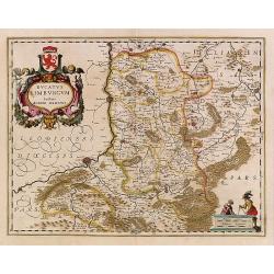
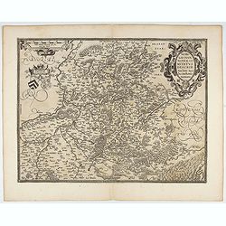
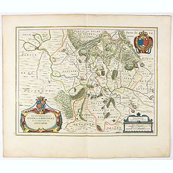
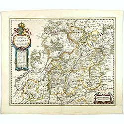
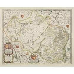
Ducatus Limburg.
In 1616 prepared by Aegidio Martini. Includes the towns of Maastricht as well as of Aachen. A very large title cartouche with two putti.
Date: Amsterdam 1639
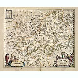
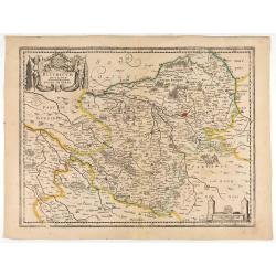
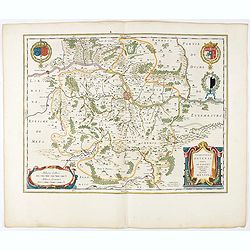
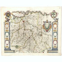
Comitatus Glatz.
Handsome map of the Silesia region with Glatz (Klodzko) at center. The forested region was renowned for its wild game and the map includes tiny illustrations of the wildl...
- $450 / ≈ €393
Date: Amsterdam, 1640
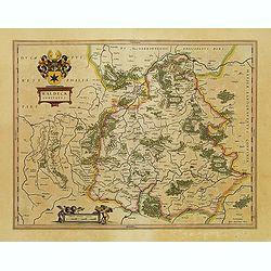
Waldeck Comitatus.
Map centered on Waldeck, Korbach, etc.
- $100 / ≈ €87
Date: Amsterdam, 1640
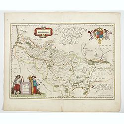
Bituricum Ducatus. Duche de Berri.
A very decorative map with beautiful cartouches of a province of France by one of the most famous map publishers. Berry is a region located in the center of France. It wa...
Date: Amsterdam, 1640
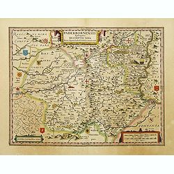
Paderbornensis Episscopatus Descriptio Nova.
Detailed map by Willem Blaeu., centered on Paderborn. Embellished with several coats of arms. Prepared by Joannes Michael Gigas (1580-1650+), a doctor, mathematician and ...
- $175 / ≈ €153
Date: Amsterdam, 1640
Mansfeldia Comitatus..
Centered on Mansfeld and prepared by Tilemano Stella (1527-1589) a German cartographer who made maps of Germany and the Holy Land.
- $100 / ≈ €87
Date: Amsterdam, 1640
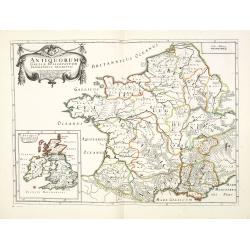
Antiquorum Galliae episcopatuum geographica descriptio. . . / Antiqui magnae Britaniae Episcopatus.
Detailed map of France during Ancient times. In lower left corner inset map of England "Antiqui magnae Britaniae Episcopatus." (160x146mm.) First published in &...
Date: Paris, ca.1641
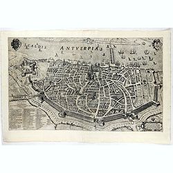
Scaldis Antverpia - Locorum Insignium ac viae triumphalis qua ser.mus princeps, Ferdinandus Austriacus, Hispaniar, Infans. etc. Antverpiam est ingressus, designatio . . .
Bird's-eye view of the city of Antwerp and the River Schelde, numbered (1-59 ) with important sites along the entry of the Cardinal Infant Ferdinand of Austria into Antwe...
- $2000 / ≈ €1747
Date: Antwerp, 1635-1641
Nobilis Hannoniae Comitatus Descrip.
Fine map of Hannonia (Hainaut), with ornate cartouches, two coats of arms, etc. Showing the cities of Charleroi, Mons, Ath, Tournay, Valenciennes, Maubeuge, etc. in Belgi...
- $600 / ≈ €524
Date: Antwerp, 1612-1641
Ducatus silasiae Wolanus. . .
An engraved 17th-century map of the Duchy of Wohlau in Poland with four cartouches in the corners. Orientated with east at the top. The decorative cartouche displaying th...
- $550 / ≈ €480
Date: Amsterdam, ca. 1641
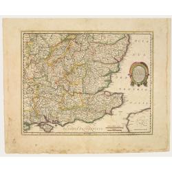
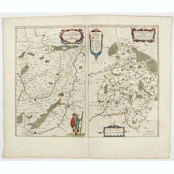
Warwicum Northamtonia Huntingdonia Cantabrigia..
Showing the south-eastern part of England.
Date: Amsterdam, 1642
Northumbria, Cumberlandia et Dunelmensis Episcopatus..
Showing the most northern part of England. The map shows Cumbria, Northumberland, Westmorland, Durham, and adjacent parts of Lancashire, Yorkshire, and Scotland.
Date: Amsterdam, 1642
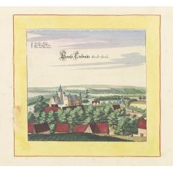
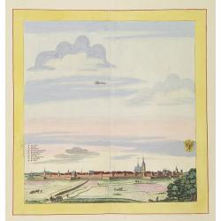
Haus trebnits an der saale.
Very decorative and rare panoramic of Trebnitz a.d Saale , Bez. Halle.The engraver and publisher of prints, Mrs. Anna Beek of the Hague, enlarged the print and mounted i...
Date: The Hague, ca. 1642
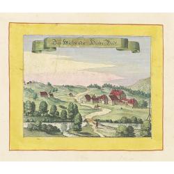
Das Wiesen oder Hiobs Badt.
Very decorative and rare panoramic town view of Wiensenbad near Annaberg im Erzgebirge.The engraver and publisher of prints, Mrs. Anna Beek of the Hague, enlarged the pri...
Date: The Hague, ca. 1642
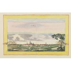
Weissensee.
Very decorative and rare panoramic town view of Weissensee in Thürigen, Bez. Erfurt.The engraver and publisher of prints, Mrs. Anna Beek of the Hague, enlarged the print...
Date: The Hague, ca. 1642
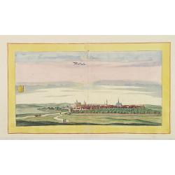
Hertzberg.
Very decorative and rare panoramic town view of Herzberg a.d. Schwarzen Elster, Bez. Cootbus.The engraver and publisher of prints, Mrs. Anna Beek of the Hague, enlarged t...
Date: The Hague, ca. 1642
Newstatt an der Orla.
Very decorative and rare panoramic of Neustadt a.d. Donau, Kr. Kelheim, Ndb.The engraver and publisher of prints, Mrs. Anna Beek of the Hague, enlarged the print and mou...
Date: The Hague, ca. 1642

Greüssen.
Very decorative and rare panoramic town view of Greussen (Thür.),Bez. Erfurt .The engraver and publisher of prints, Mrs. Anna Beek of the Hague, enlarged the print and m...
Date: The Hague, ca. 1642
Schweet.
Very decorative and rare panoramic town view of Schwedt a.d Oder, Bez. Frankfurt a.d. Oder.The engraver and publisher of prints, Mrs. Anna Beek of the Hague, enlarged the...
Date: The Hague, ca. 1642
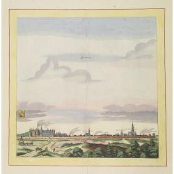
Werben.
Very decorative and rare panoramic town view of Werben a.d. Elbe, Bez. Magdeburg.The engraver and publisher of prints, Mrs. Anna Beek of the Hague, enlarged the print and...
Date: The Hague, ca. 1642
Bützom.
Very decorative and rare panoramic town view of Bützom.The engraver and publisher of prints, Mrs. Anna Beek of the Hague, enlarged the print and mounted it on larger pap...
Date: The Hague, ca. 1642
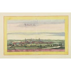
Statt und Ambtt Wantzleben.
Very decorative and rare panoramic town view of Wanzleben, Bez. Magdeburg.The engraver and publisher of prints, Mrs. Anna Beek of the Hague, enlarged the print and mounte...
Date: The Hague, ca. 1642
Helvetia cum finitimis regionibus confoederatis.
A typically detailed and finely engraved map of Switzerland by Blaeu, including the cities of Basel, Zürich, Bern, Lucerne, Fribourg, etc. The map is embellished with tw...
Date: Amsterdam, 1643
Les Souverainetez de Sedan et de Raucourt.. Doncheri.
A very decorative map with beautiful large cartouches of a province of France by one of the most famous map publishers. From early on Willem Jansz. Blaeu aimed of publis...
- $175 / ≈ €153
Date: Amsterdam, 1644
Territorium Metense. Auctore Ab. Fabert.. Le Pais Messin.
A very decorative map of part of Lorraine with beautiful cartouches. Orientated with West on top. Centered on Metz. From early on Willem Jansz. Blaeu aimed of publishing...
- $300 / ≈ €262
Date: Amsterdam, 1644
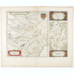
Lemovicum.. Lymosin. / Topographia Limaniae. . .
Two maps on one sheet. The author of the map of Lymosin was the French physician and cartographer Jean du Fayen. From early on Willem Jansz. Blaeu aimed of publishing an...
- $175 / ≈ €153
Date: Amsterdam, 1644
Xaintonge et Angoumois.
This map features a portion of western coastal France, north of Bordeaux with Ile de Ré and Ile Oléron. Two large cartouches show cherubs with grapes and wheat, and tw...
- $450 / ≈ €393
Date: Amsterdam, 1644
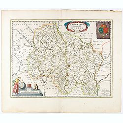
Cadurcium Vernaculé Querci.
Detailed map of a province of France by one of the most famous map publisher. Centered on Cahors.In the lower-left corner, a colored scale cartouche surmounted by a monke...
Date: Amsterdam, 1644
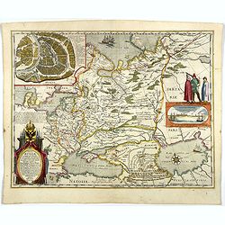
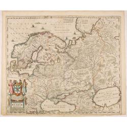
Tabula Russiae.
A re-issue, by Willem Blaeu, of Hessel Gerritsz' rare and influential map of Russia.This fine map was compiled from manuscripts brought back from Russia, by Isaac Massa, ...
Date: Amsterdam, 1644
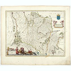
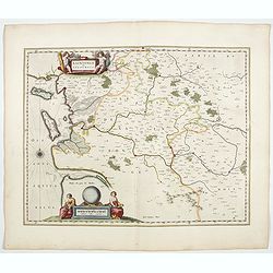
Belsia vulgo La Beausse.
In the left-hand lower part of the image a beautiful contemporary cartouche with goddess Ceres [agricultural] holding a reaping-hook in her right hand and receiving with ...
- $200 / ≈ €175
Date: Amsterdam , 1644

Europa recens descripta à Guilielmo Blaeuw.
On either side, columns depicting the manner of dress in the major countries of Europe, surmounted by nine city views and plans.For European mapmakers their own continent...
Date: Amsterdam, 1644
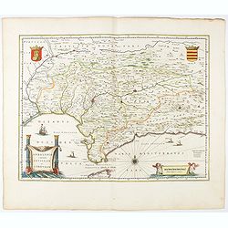
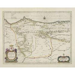
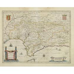
Andaluzia continens Sevillam.
Features the province of Andalucia and the city of Seville, but also depicts the Straights of Gibraltar, know in classical times as the Pillars of Hercules. Córdoba, Má...
- $350 / ≈ €306
Date: Amsterdam, 1644
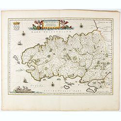
Britannia Ducatus. Duché de Bretaigne.
Map of Bretagne in France. From early on Willem Jansz. Blaeu aimed of publishing an atlas to compete with the Hondius-Jansson Atlas. By 1630, he had published at least 1...
- $650 / ≈ €568
Date: Amsterdam, 1644
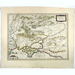
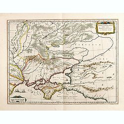
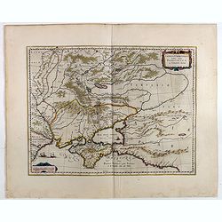
Taurica Chersonesus.
One of the earliest detailed maps of the Crimea and Ukraine between the northern coast of the Black Sea and Moscow.With the engraved signature of Gerard Mercator in lower...
- $300 / ≈ €262
Date: Amsterdam, 1639-1644
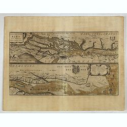
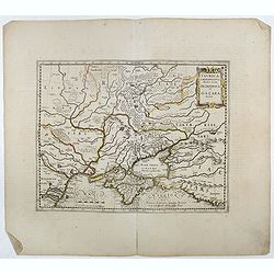
Celeberrimi Fluvis Albis nova delineatio. . .
A decorative map from a 1640's Latin text edition of Blaeu's "Theatrum Orbis Terrarum, Sive Atlas Novis." The River Elbe is depicted in two sections from the mo...
- $80 / ≈ €70
Date: Amsterdam, 1644
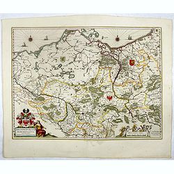
Brandeburgum Marchionatus. . .
Decorative map by Willem Blaeu centered on Berlin and Brandenburg, and part of Poland and Pomerania, Mecklenburg and Rugia with excellent detail of forests, rivers, towns...
- $250 / ≈ €218
Date: Amsterdam, 1644
Comitatus Glatz.
Nice map by Willem Blaeu of the Silesia region with Glatz (Klodzko) at center. The forested region was renowned for its wild game and the map includes tiny illustrations ...
- $450 / ≈ €393
Date: Amsterdam, 1644
Ducatus Silesiae Glogani Vera Delineatio . . .
Map of Silesia showing the area of Glogow. French text on back. More about Willem Blaeu. [+]
- $350 / ≈ €306
Date: Amsterdam, 1644
Silesia Inferior. . .
Decorative map prepared by Jonas Scultetus, a Silesian cartographer (1603-1664). More about Willem Blaeu. [+]
- $300 / ≈ €262
Date: Amsterdam, 1644
Taurica Chersonesus, Nostra aetate Przecopsca, et Gazara dicitur.
Part of Russia with in the north Smolensk and Moscow and in the south the Black Sea. More about Willem Blaeu. [+]
- $300 / ≈ €262
Date: Amsterdam, 1644
Picardia Regio Belgica.
Map of the northern region of Picardy. The region is well known due to the 4 major battles fought between France, Britain and Germany between 1915-18 during World War I. ...
- $400 / ≈ €349
Date: Amsterdam, 1644
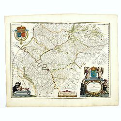
Veromanduorum.. Vermandois / Gouvernement de la Capelle.
A very decorative map with beautiful cartouches of a province of France by one of the most famous map publishers. Signed by Guilielmus Blaeu.From early on Willem Jansz. B...
- $220 / ≈ €192
Date: Amsterdam, 1644
Le Gouvernement de l'Isle de France.
A very detailed map of Ile de France centered on Paris. Showing Beauvais, Compiègne, Noyon, Laon, Soisson, Vernon, Mante, Pontoise, Meaux, etc.Adorned with the royal arm...
- $300 / ≈ €262
Date: Amsterdam, 1644
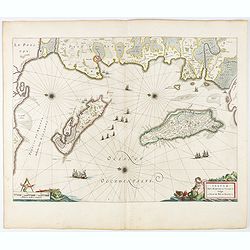
Insulae Divi Martini et Uliarus, vulgo L'Isle de Ré.. Oleron.
Map of Ré and Oléron islands. Depicting the west coast of France, showing La Rochelle. Several vessels and sailing ships dot the Atlantic ocean.Three windroses indicate...
- $950 / ≈ €830
Date: Amsterdam, 1644
Archiepiscopatus Maghdeburgensis et Anhaltinus Ducatus.
A very nice, decorative copper engraved map of Lower-Saxony and Saxony-Anhalt by Blaeu. With one figural cartouche. Bounded on the west by the River Wesel between Nienbur...
- $80 / ≈ €70
Date: Amsterdam, 1645
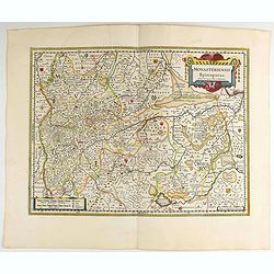
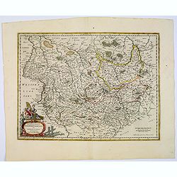
Monasteriensis Episcopatus.
A very detailed map of Germany centered on Linge. Showing Wessel to the top of the map, and Oldenburg to the right. North is oriented to the right. The map is further ado...
Date: Amsterdam 1645
Wirtenberg Ducatus.
Map depicting the area south of Heidelberg, including Stuttgart, Ulm, etc.. and river Danube.A beautiful coat of arms and a splendid title cartouche decorated by three ch...
Date: Amsterdam, 1645
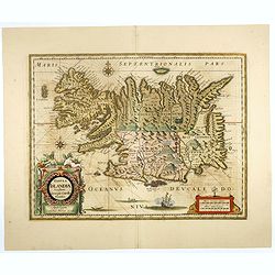
Tabula Islandiae..
This handsome map of Iceland was based on information from a Dutch navigator named Joris Carolus in about 1620. The map shows the influence of both versions of bishop Gud...
- $1100 / ≈ €961
Date: Amsterdam, 1645
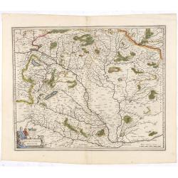
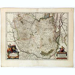
Hungaria Regnum.
Detailed map of Hungary centered on Budapest. Including the towns of Vienna, Zagreb as well.As Willem Blaeu died in 1638 most of his maps are actually published by his so...
Date: Amsterdam, 1645
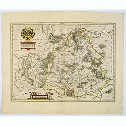
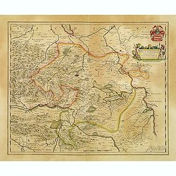
Waldeck Comitatus.
Blaeu's attractive map of the region of Waldeck. Forests, hills and rivers all feature, along with towns villages and cities. Decorative title cartouche surmounted by coa...
- $100 / ≈ €87
Date: Amsterdam, 1645
Taurica Chersonesus, Nostra aetate Przecopsca, et Gazara dicitur.
Detailed map of the Ukraine, Russia with in the north Smolensk and Moscow and in the south the Black Sea. Shows ports, fortified cities and the mouths of the Danube. Mino...
- $750 / ≈ €655
Date: Amsterdam, 1645
Legionis Regnum et Asturiarum Principatus.
A very decorative map by Willem Blaeu of the Spanish Province Asturias, Castile and Léon, including the towns of Oviedo, Leon, Santander, Valladolid, etc. With two fine ...
Date: Amsterdam, 1645
Andalusia continens Sevillam et Cordubam.
Features the province of Andalusia and the city of Seville, but also depicts the Straights of Gibraltar, know in classical times as the Pillars of Hercules. The title car...
Date: Amsterdam, 1645
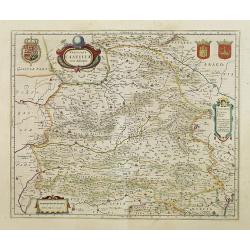
Utriusque Castillae nova descriptio.
Blaeu's map of León-Castilla, showing Zaragoza, Valencia, Alicante, Cartagena, Madrid, Cordoba, Seville, Salamanca, Palencia, Segovia, Toledo, Cuenca, Granada, etc. Incl...
Date: Amsterdam, 1645
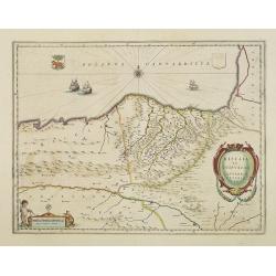
Biscaia et Guipuscoa Cantabriae veteris Pars.
Shows cities of Bilbao and Laredo, and includes a charming vignette of a putti with surveying equipment, being observed by a kitten. With Dutch text on verso.More about m...
Date: Amsterdam, 1645
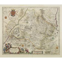
Navarra Regnum.
Decorative map of the region which includes the city of Pamplona at the centre of the map, Bayonne and San Sebastian. Highly decorative figured cartouche bottom left. Fou...
Date: Amsterdam, 1645
Arragonia Regnum.
A beautiful, highly decorative map of Aragon, centered on Saragossa and extending to Balbasdtor, Huesca, Calataiud, Tortosa, Tervel, Albarrazin and Cuenca. Towns, rivers,...
Date: Amsterdam, 1645
Novissima Russiae Tabula.
Detailed map of Russia including Scandinavia. Bottom left title cartouche and dedication. Prepared by Isaac Masso. Latin text on the verso.
Date: Amsterdam, 1645
Juliacensis et Montensis Ducatus / De Hertoghdomen Gulick en Berghe.
Detailed map centered on Cologne. Embellished with scale cartouche with cherubs, a cartouche with a putti inside holding two coats of arms. Lower left corner, the title c...
- $150 / ≈ €131
Date: Amsterdam, 1645
Zuydhollandia stricte sumta.
The count ship of Holland was subdivided into a number of bailiwicks. The most southerly bailiwick, bordering on Brabant was named Zuid-Holland. Many floods changed the a...
Date: Amsterdam, 1645
Taurica Chersonesus, Nostra aetate Prezecopsca, et Gazara dicitur.
Part of Russia with in the north Smolensk and including Moscow and in the south the Black Sea.More about Willem Blaeu. [+]Taurica, Tauric Chersonese, and Taurida were nam...
- $500 / ≈ €437
Date: Amsterdam, 1645
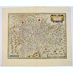
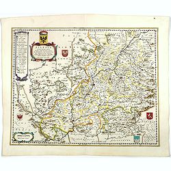
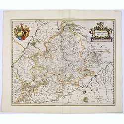
Westphalia Ducatus.
Originally engraved for Jodocus Hondius II, at his death in August 1629, this map was, among 39 other copper plates, purchased by Willem Blaeu who deleted Hondius' name a...
Date: Amsterdam, 1645
Quarta pars Brabantiae cujus caput Sylvaducis.
The coat of arms of Brabant and 's-Hertogenbosch do appear on the map. But the municipal arms in the columns on right and left-hand side have not yet been filled in. The ...
Date: Amsterdam, 1645
Brabantia Ducatus.
A very decorative map by Willem Blaeu with west is at the top. On the lower left a magnificent cartouche with a sitting female figure carrying a globe and compasses and t...
Date: Amsterdam, 1645
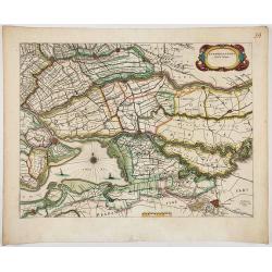
Zuydhollandia stricte sumta.
The count ship of Holland was subdivided into a number of bailiwicks. The most southerly bailiwick, bordering on Brabant was named Zuid-Holland. Many floods changed the a...
- $350 / ≈ €306
Date: Amsterdam, 1645
Afbeeldinge vande vermaerde seehaven .. Duynkerken..
Blaeu's map of the coast of the French coast from Duinkerk till Waldamme. In an inset, lower right the continuation till Calais. Many ships offshore Duinkerk, with soundi...
- $500 / ≈ €437
Date: Amsterdam, 1645
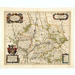
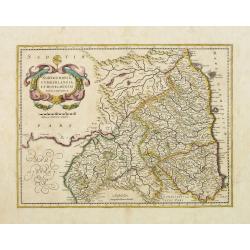
![Perchensis Comitatus [together with] Comitatus Blesensis.](/uploads/cache/44784-250x250.jpg)
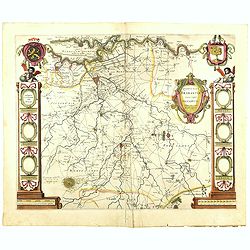
Perchensis Comitatus [together with] Comitatus Blesensis.
Two maps on one sheet, each with its own decorative title cartouche. These maps detail the region of the Loire River. Perchensis includes the cities of Mortagne, Nogent-l...
Date: Amsterdam , ca 1645
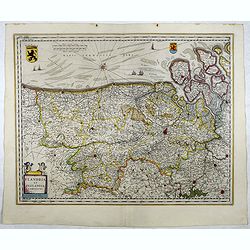
Flandria et Zeelandia Comitatus.
Includes Flanders and Zeeland. The map originally engraved in 1641 for Sanderus 'Flandria Illustrata', was used several times in Blaeu's atlases.More about maps by Willem...
- $250 / ≈ €218
Date: Amsterdam, 1645
Quarta pars Brabantiae cujus caput Sylvaducis.
The coat of arms of Brabant and 's-Hertogenbosch do appear on the map. But the municipal arms in the columns on right and left-hand side have not yet been filled in. The ...
Date: Amsterdam, 1645
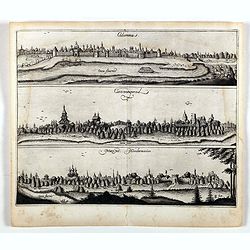
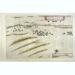
Colomna - Cassimogorod - Moruma.
Three panoramic views of Colomna - Cassimogorod - Moruma on one sheet. From the rare first edition "Offt begehrte Beschreibung der newen orientalischen Rejse, so dur...
- $300 / ≈ €262
Date: Schleßwig, Zur Glocken, 1647
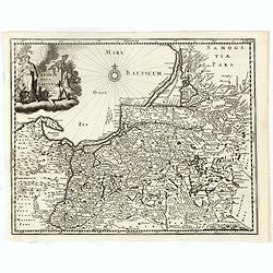
Prussiae nova tabula.
Rare map of Prussia with nowadays Poland. The map features a bold title cartouche, a ship, compass rose, and a sea monster in the Baltic Sea. The map was prepared by the ...
- $550 / ≈ €480
Date: Amsterdam, 1647
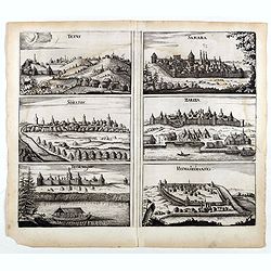
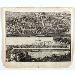
Tetus - Samara - Soratof - Zariza - Tzornogar - Kusmamedianski.
Panoramic views of Tetus, Samara, Soratof, Zariza, Tzornogar and Kusmamedianski on one sheet. From the rare first edition "Offt begehrte Beschreibung der newen orien...
- $300 / ≈ €262
Date: Schleßwig, Zur Glocken, 1647
Tarku.
An early of Tarku in the Republic of Dagestan. From the rare first edition "Offt begehrte Beschreibung der newen orientalischen Rejse, so durch Gelegenheit einer Ho...
- $250 / ≈ €218
Date: Schleßwig, Zur Glocken, 1647
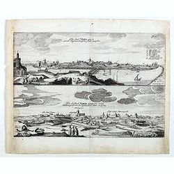
Die stadt Narva . . .
Two panoramic views of the city of Narva, on one sheet. Narva is the third largest city in Estonia. It is located at the eastern extreme point of Estonia, at the Russian...
- $250 / ≈ €218
Date: Schleßwig, Zur Glocken, 1647
Kom - Kaschan.
An early of Kom and Kaschan on one sheet. From the rare first edition "Offt begehrte Beschreibung der newen orientalischen Rejse, so durch Gelegenheit einer Holstei...
- $250 / ≈ €218
Date: Schleßwig, Zur Glocken, 1647
Territorium Abbatiae Herefeldensis - 't Stift Hirszfeldt.
Detailed map centered on Hirschfelt. Title cartouche embellished with two cherubs.
- $250 / ≈ €218
Date: Amsterdam, 1647
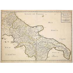
Royaume de Naples..
Fine map of the southern part of Italy.This edition carries the date 1648, engraved by AB. De la plaets. With the manuscript number in the upper right corner.Nicolas Sans...
Date: Paris, 1648
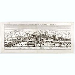
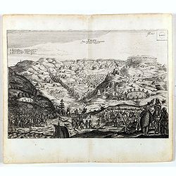
La ville archie-piscopale et primatiale de Vienne en Dauphiné.
View of Vienne, engraved by François de La Pointe.
- $600 / ≈ €524
Date: Paris, 1648
