Browse Listings in America
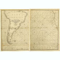
A general chart of the South Atlantic Ocean Drawn by J.W.Norie hydrographer. Revised & Corrected 1854.
A 2-sheet chart of the South Atlantic Ocean, showing the coast of South America from the mouth of the Amazon to Quito in Peru. The right hand part showing Africa's coast ...
- $600 / ≈ €524
Date: London, 1854
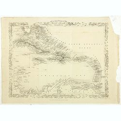
West India Islands.
Map of the West Indies, published by "The London Printing and Publishing Company". Drawn and engraved by John Rapkin.
- $75 / ≈ €66
Date: London, 1854
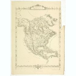
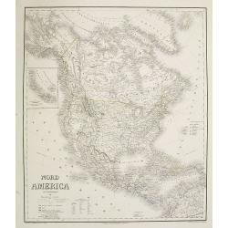
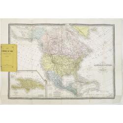
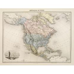
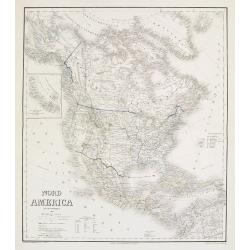
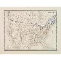
North America.
Map of North America, published by "The London Printing and Publishing Company". Drawn and engraved by John Rapkin.
- $100 / ≈ €87
Date: London, 1854
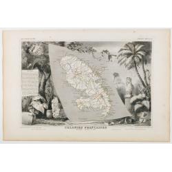
Colonies Françaises. Martinique - Amérique du Sud.
Carte du Département de la Martinique entourée de motifs décoratifs représentant les productions de l'île telles que le tabac et le sucre. In original o.l. color, f...
Date: Paris, 1854
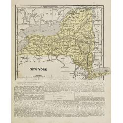
New York.
Map of New York. From Sidney E. Morse''s: System of Geography for the use of schools , published by Harper and brothers, 329 Pearl Street, New York.An 150 years old map w...
- $30 / ≈ €26
Date: New York, 1855
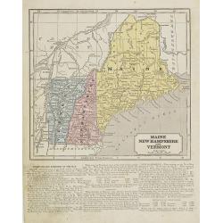
Maine, New Hampshire and Vermont.
Map of Maine, New Hampshire and Vermont.. On the verso, a world map of North and South America with its northern and southern hemispheres. From Sidney E. Morse''s: System...
Date: New York, 1855
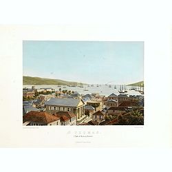
St. Thomas (parti af Byen og Havnen).
A beautiful view of the harbour on the island St. Thomas. This view shows much of the town, bay and surrounding area. One of a series of six lithographs of St. Thomas pro...
Date: Copenhagen, Baerentzen Co, 1856
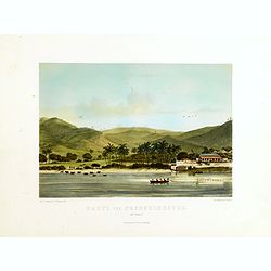
Parti ved Frederikssted (St. Croix).
Early town-views of the small town of Frederiksted on the island of St. Croix. This view shows much of the harbor and a portion of the town's waterfront. one of a series ...
Date: Copenhagen, Baerentzen / Co, 1856
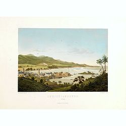
Christianssted. (St.Croix).
A beautiful view of the small town of Christiansted on the island of St. Croix. This view shows much of the harbour and a portion of the town's waterfront. one of a serie...
- $900 / ≈ €786
Date: Copenhagen, Baerentzen & Co, 1856
The Bucareli Promenade - Paseo de Bucareli - Promenade de Bucareli.
Lithographed plate of the Bucareli Promenade of Mexico City. The plate has caption title in English, Spanish and French, from the rare publication MEXICO Y SUS ALREDEDORE...
Date: Mexico, Establecimiento Litografico de Decaen, 1855-1856
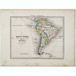
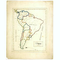
Nuovo Mondo parte Meridionale.
Uncommon map of South America prepared by Francesco Costantino Marmocchi. Above the map "Geografia Commerciale". From "Il Globo Atlante di carte Geografich...
Date: Genova, Paolo Rivara fu Giacomo, 1858
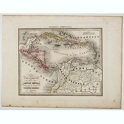
Le Indie Ocidentali ( Antille maggiori e minori, ecc) L'America Centrale . . .
Uncommon map of Central America and the Antilles prepared by Francesco Costantino Marmocchi. Above the map "Geografia Commerciale". From "Il Globo Atlante ...
Date: Genova, Paolo Rivara fu Giacomo, 1858
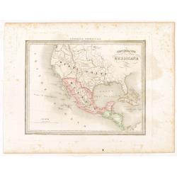
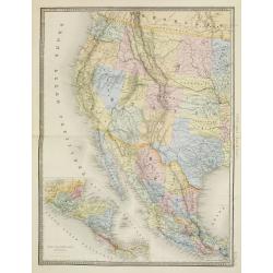
Confederazione Messicana.
Uncommon map of Mexico and the Transmississippi West, includes the name Texas, prepared by Francesco Costantino Marmocchi. Above the map "Geografia Commerciale"...
Date: Genova, Paolo Rivara fu Giacomo, 1858

Een Danser der Californische Indiaanen.
Decorative, original hand colored, woodcut engraving illustrating a native American dancer from California.
- $35 / ≈ €31
Date: Amsterdam, ca. 1860
![Westelijk Halfrond. [Western hemisphere]](/uploads/cache/25524-250x250.jpg)
Westelijk Halfrond. [Western hemisphere]
Uncommon world map view of the western and eastern hemispheres of North and South America, Asia. Lithography by J.H. van Weijer, published in Atlas der geheele Aarde [?] ...
Date: Groningen, ca. 1860
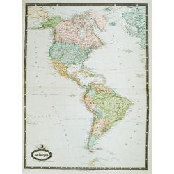
Amérique. . .
Very detailed map from Atlas Sphérodidal & Universel de géographie , Prepared by F.A.Garnier and edited by Jules Renouard, rue de Tournon, Paris. With decorative ti...
- $300 / ≈ €262
Date: Paris, 1861
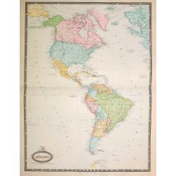
Amérique..
Very detailed map from Atlas Sphéroïdal & Universel de géographie. Prepared by F.A.Garnier and edited by Jules Renouard, rue de Tournon, Paris. With decorative tit...
- $175 / ≈ €153
Date: Paris, 1861
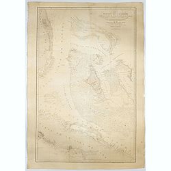
Carta del Gran Banco de Bahama parte de la Isla de Cuba y Costa de la Florida.
A large marine chart, engraved by Juan Noguera and C.Marquerie, produced by the Direccion de Hydrografia, under the direction of Jose de Quesada, who was the then chief o...
- $1750 / ≈ €1529
Date: Madrid, 1858-1866
Nord America mit Westindien. . .
A superbly engraved and colored map of North America and the West Indies with a host of place names and meticulously rendered topography.Includes an inset of the Aleutian...
Date: Weimar, 1867
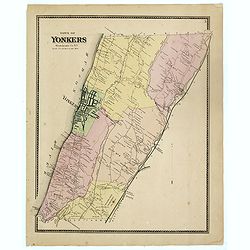
Town of Yonkers Westchester Co. NY
Fine lithographed map of the town of Yonkers. The map provides the names of specific homeowners, as well as information about the occupations and physical locations of th...
Date: New York, 1867
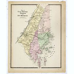
Plans of East Chester Pleham and New Rochelle. Westchester Co.
Fine lithographed map of East Chester Pelham and New Rochelle. The map provides the names of specific homeowners, as well as information about the occupations and physica...
Date: New York, 1867
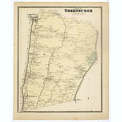
Town of Greenburgh.
Fine lithographed map of the town of Greenburgh. The map provides the names of specific homeowners, as well as information about the occupations and physical locations of...
Date: New York, 1867
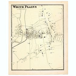
White Plains.
Fine lithographed map of White Plains. The map provides the names of specific homeowners, as well as information about the occupations and physical locations of the vario...
Date: New York, 1867
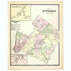
Town of Mt Pleasant. Westchester Co. NY.
Fine lithographed map of the town of Mt Pleasant. The map provides the names of specific homeowners, as well as information about the occupations and physical locations o...
Date: New York, 1867
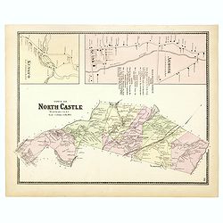
Town of North Castle.
Fine lithographed map of the town of North Castle. The map provides the names of specific homeowners, as well as information about the occupations and physical locations ...
Date: New York, 1867
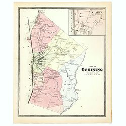
Town of Ossining. Westchester Co. NY.
Fine lithographed map of the town of Ossining. The map provides the names of specific homeowners, as well as information about the occupations and physical locations of t...
Date: New York, 1867
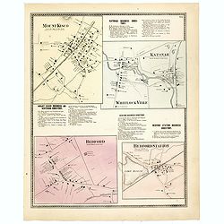
Mount Kisco / Bedford / Katonah / Bedford Station.
Fine lithographed map of Mount Kisco / Bedford / Katonah / Bedford Station. The map provides the names of specific homeowners, as well as information about the occupation...
Date: New York, 1867
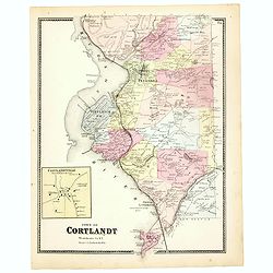
Town of Cortlandt.
Fine lithographed map of the town of Cortlandt. The map provides the names of specific homeowners, as well as information about the occupations and physical locations of ...
- $90 / ≈ €79
Date: New York, 1867
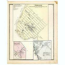
Town of Verplanck / Crugers / Croton Landing.
Fine lithographed map of the town of Verplanck / Crugers / Croton Landing. The map provides the names of specific homeowners, as well as information about the occupations...
- $90 / ≈ €79
Date: New York, 1867
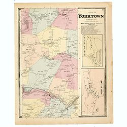
Town of Yorktown.
This is a fine lithographed map of Yorktown. The map provides the names of specific homeowners, as well as information about the occupations and physical locations of the...
- $90 / ≈ €79
Date: New York, 1867
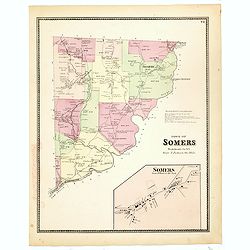
Town of Somers.
This is a fine lithographed map of the town of Somers. The map provides the names of specific homeowners, as well as information about the occupations and physical locati...
- $90 / ≈ €79
Date: New York, 1867
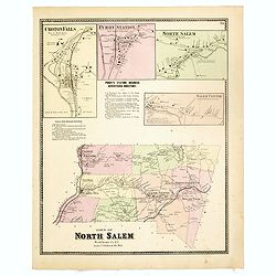
Town of North Salem.
Fine lithographed map of the town of North Salem. The map provides the names of specific homeowners, as well as information about the occupations and physical locations o...
- $90 / ≈ €79
Date: New York, 1867
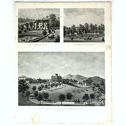
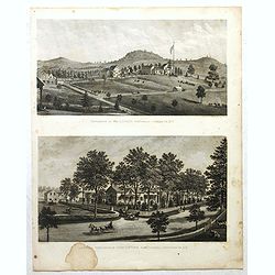
Property of F.A.Halstead Bedford Station, The Halstead Homestead at Bedford and Inland Vale residence of J.S.Libby, Westchester Co. NY North Salem.
Three heliographic prints on one sheet : "Property of F.A.Halstead Bedford Station", "The Halstead Homestead at Bedford" and "Inland Vale residen...
- $100 / ≈ €87
Date: New York, 1867
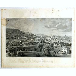
View of Brewsters' Putnam Co.N.Y.
Heliographic print of Brewsters' Putnam Co.N.Y." after a design by R.K.Sneden.From Beer's famous county atlas "Atlas of New York and vicinity, a documentary rec...
- $100 / ≈ €87
Date: New York,1867
Résidence of WM H.Drew Southeast Putnam Co.N.Y / Lake Farm Résidence of John V.Storm East Fiskill Dutches Co.N.Y.
Two heliographic prints on one sheet : " Résidence of WM H.Drew Southeast Putnam Co.N.Y / Lake Farm Résidence of John V.Storm East Fiskill Dutches Co.N.Y." af...
- $100 / ≈ €87
Date: New York,1867
Todd Homestead / Résidence of B. Travis Katonah N.Y / Reisig & HexamersBarn Ivy Hill / Résidence of W.F Bearns
Four heliographic prints on one sheet : "Todd Homestead / Résidence of B. Travis Katonah N.Y / Reisig & HexamersBarn Ivy Hill / Résidence of W.F Bearns "I...
- $100 / ≈ €87
Date: New York,1867
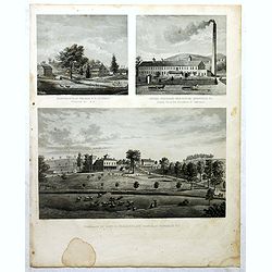
Residence of A.S. Doane Doanesburg Putnam Co. N.Y. - N. L. Thompsons's lake Mahopac - The Gregory House lake Mahopac Putnam Co N. Y. Lewis H. Gregory Proprietor.
Three heliographic prints on one sheet : "Residence of A.S. Doane Doanesburg Putnam Co. N.Y. (120x150mm.) / N. L. Thompsons's lake Mahopac (120 x 160mm.) / The Grego...
- $100 / ≈ €87
Date: New York,1867
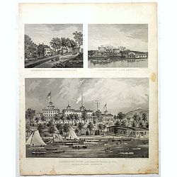
Mount Vernon Valley Residence of S.J. Powers / Borden condensed milk factory brewsters N.Y / Residence of Dan D. Chamberlain South East Putman Co. N.Y.
Three heliographic prints on one sheet : "Mount Vernon Valley Residence of S.J. Powers (135 x 155mm.) / Borden condensed milk factory brewsters N.Y (135 x 155mm.) / ...
- $100 / ≈ €87
Date: New York,1867
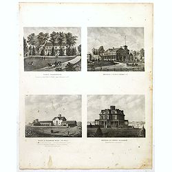
"Old Dutch church, "Sleepy Hollow" / Residence of A.B Baylis esq Bedford village N.Y / "Sunny side" former residence of Washington Irving."
Three heliographic prints on one sheet : "Old Dutch church, "Sleepy Hollow" / Residence of A.B Baylis esq Bedford village N.Y / "Sunny side" form...
- $100 / ≈ €87
Date: New York,1867
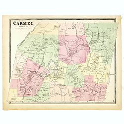
Town of Carmel.
Fine lithographed map of the town of Carmel. From : "Atlas of New York and vicinity" published by Beers, Ellis & Soule, 95 Maiden Lane, New York. The map pr...
Date: New York, 1867
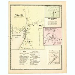
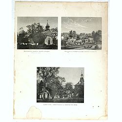
Town of Carmel / Towners Station / South East Centre / Mill Town.
Fine lithographed map of the town of Carmel / Towners Station / South East Centre / Mill Town. From "Atlas of New York and vicinity" published by Beers, Ellis ...
Date: New York, 1867
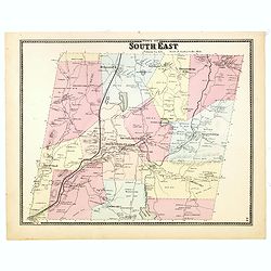
Town of South East.
Fine lithographed map of the town of South East. From : "Atlas of New York and vicinity" published by Beers, Ellis & Soule, 95 Maiden Lane, New York.The map...
Date: New York, 1867
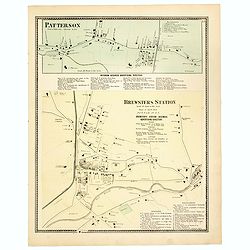
Town of Patterson / Brewsters Station.
Fine lithographed map of the town of Patterson / Brewsters Station. From : "Atlas of New York and vicinity" published by Beers, Ellis & Soule, 95 Maiden Lan...
Date: New York, 1867
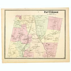
Town of Patterson.
Fine lithographed map of the town of Patterson. From : "Atlas of New York and vicinity" published by Beers, Ellis & Soule, 95 Maiden Lane, New York.The map ...
Date: New York, 1867
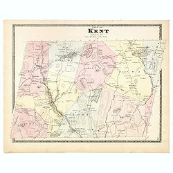
Town of Kent.
Fine lithographed map of the town of Kent. From :"Atlas of New York and vicinity" published by Beers, Ellis & Soule, 95 Maiden Lane, New York.The map provid...
Date: New York, 1867
Plano de la Hacienda de Juana de Oro.
Wall-map sized map in 2 sheets, if joined 940 x 1300mm., showing the Hacienda (farm) of Juana de Oro in Ecuador. The cocoa farm was owned by Mrs. Leonor Carbo of Higgins ...
Date: Guayaquil ( Equateur), 1868
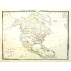
Carte de L'Amérique du Nord. . .
Detailed map of Nord America and Central America giving good detail along the east coast and the Lakes. Including San Francisco, Monterey, etc.With inset map of Dominican...
- $250 / ≈ €218
Date: Paris, 1870
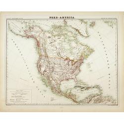
Nord-America
Large and detailed map of North and Central America. With inset key to the different possessions, Republic of Mexico, - Central America, States and territories.Lithograph...
- $150 / ≈ €131
Date: Berlin, 1872
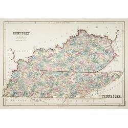
Kentucky.
A detailed lithographed map of Kentucky. Published by Adam (1784-1874) and Charles Black, publishers active in Edinburgh.
- $100 / ≈ €87
Date: Edinburg, 1874
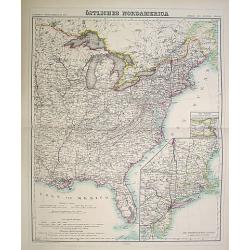
Östliches Nordamerica. . .
An extensive and detailed map of North America. With inset map lower right of "Die Nordöstlichen Staten". With color key in lower left.The map is prepared by H...
- $200 / ≈ €175
Date: Weimar 1874
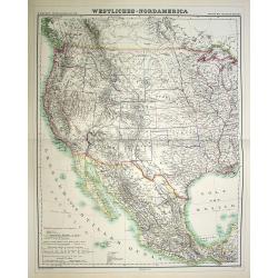
Westliches-Nordamerica.
An extensive and detailed map of North America. With color key in lower left. The map is prepared by H. Kiepert and published in Berlin by Dietrich Reimer and engraved b...
- $200 / ≈ €175
Date: Weimar, 1874
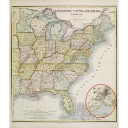
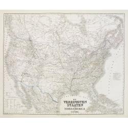
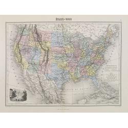
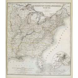
Die Vereinigten Staten von Nordamerika (Ostlicher theil).
Detailed map of eastern part of the United states. In lower right hand corner inset map of New York Bay, including, NY, Newark, Staten Island.The map is prepared by C.Gr�...
- $450 / ≈ €393
Date: Weimar, 1874
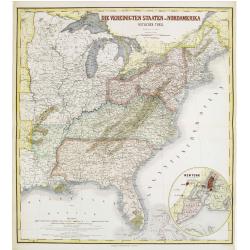
Die Vereinigten Staten von Nordamerika (Ostlicher theil).
Detailed map of eastern part of the United states until the border of Texas. In lower right hand corner inset map of New York Bay, including, NY, Newark, Staten Island.Th...
- $450 / ≈ €393
Date: Weimar, 1874
Amérique du Nord.
Decorative map of Northern America from Géographie Universelle, Atlas Migeon. published by J. Migeon. Nice engraving at the lower left hand of New York with the Statue o...
Date: Paris, 1874
Die Vereinigten Staten von Nordamerika nebst Canada.
Large and very detailed German map issued before the outbreak of the Civil War. It covers the United States, parts of Canada, and Mexico. The states and territories are s...
- $400 / ≈ €349
Date: Weimar, 1874
Nord America mit Westindien.
Detailed map of North America. With a color key indicating US, English, French, Dutch, Spanish, Portuguese, Danish possessions in the region with original outline color d...
- $300 / ≈ €262
Date: Weimar, 1874
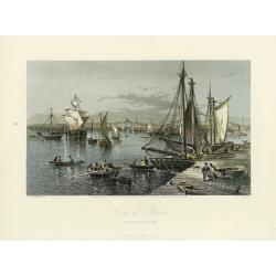
City of Boston.
A handsome mid 19th century panoramic view of the city of Boston as seen from the southern part of it's harbor. Many monuments are clearly visible, including the State Ho...
- $250 / ≈ €218
Date: New York, 1872-1874
Etats-Unis.
Decorative map of the United States from Géographie Universelle, Atlas Migeon. Oklahoma is Indian Territory with Public Lands in the panhandle. With an engraving lower l...
- $75 / ≈ €66
Date: Paris, 1874
Nouvelle carte de l'Amérique Septentrionale et des iles qui en dépendent dressée par H. Brué. . .
Very large, highly detailed, and uncommon issue of the map of North and Central America (ca. 1:13,888,000) prepared by H. Brué and improved by A.Vuillemin. Showing main ...
- $500 / ≈ €437
Date: Paris, 1875
Die Vereinigten Staaten von Nordamerika (Ostlicher theil).
This is a 1876 example of C. Graf's map of the United States of America. The map covers the eastern part of the United States from eastern Texas to the Atlantic, extendin...
- $300 / ≈ €262
Date: Weimar, 1876
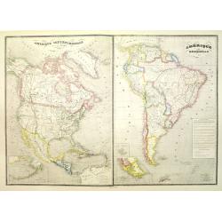
Amérique septentrionale dressée par C.V. Monin. . . / Amérique méridionale. . .
Two maps on one sheet. North America to the left, shows major cities, political divisions, and areas of Indian habitation for North America and the West Indies and state ...
- $300 / ≈ €262
Date: Paris, c.1876
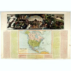
América del Norte.
Beautiful, large map of North America with a stunning panorama at the top of figures representing the continents, etc. A rare and decorative map. From "Atlas geográ...
- $550 / ≈ €480
Date: Madrid, 1877
États-Unis et Nouvelle Bretagne.
A detailed map of the United States. All different States are divided by an orange border line.
- $120 / ≈ €105
Date: Paris, 1880
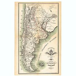
Carte générale de la République Argentine dressée d'après les données les plus récentes.
An UpToDate map of the Argentinian Republic published in Basel by "le Bureau Officiel d'Information de la République Argentine". Detailed map of Argentina show...
- $350 / ≈ €306
Date: Basel, 1887
Etats Unis (Etats de l' Ouest).
Large format highly detailed map of the states and territories of the West, with Central America, included in a large inset titled "Etats de l'Amerique Centrale"...
Date: Paris, 1889
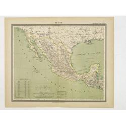
Mexico.
Decorative territorial map showing the Southwest of the United States with Mexico, Baja California and the neighboring states Arizona, New Mexico and Texas. The map exten...
Date: Glogau, 1892
![[South America].](/uploads/cache/46140-250x250.jpg)
[South America].
Alexey Afinogenovich Ilyin was a lieutenant general and cartographer (1832-1889). In 1856, after graduating from the Academy of the General Staff, he was at the military ...
- $100 / ≈ €87
Date: St. Petersburg, 1899
![[North America].](/uploads/cache/46142-250x250.jpg)
[North America].
Alexey Afinogenovich Ilyin was a lieutenant general and cartographer (1832-1889). In 1856, after graduating from the Academy of the General Staff, he was at the military ...
- $150 / ≈ €131
Date: St. Petersburg, 1899
S America by Mas T.J. Sackels.
Pen and ink on card board. Map of South America drawn by T.J.Shackels. Probably a school exercise.
- $120 / ≈ €105
Date: England, ca. 1900
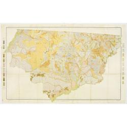
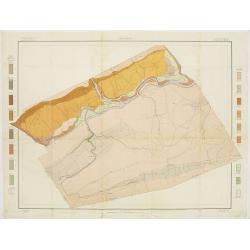
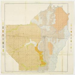
Soil map - Florida, Gadsden County sheet.
Early color lithographed soil map by Julius Bien & Co. in New York for the Department of Agriculture. Legends at the side give detail on soil type, etc. They also inc...
- $40 / ≈ €35
Date: New York, 1903
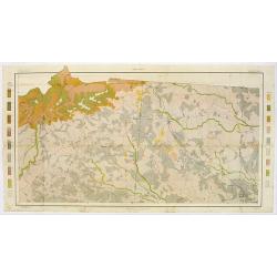
Soil map - South Carolina Campobello Sheet.
Early color lithographed soil map by Julius Bien & Co. in New York for the Department of Agriculture. Legends at the side give detail on soil type, etc. They also inc...
- $50 / ≈ €44
Date: New York, 1903
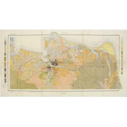
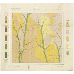
Soil map - Virginia Norfolk Sheet.
Soil map printed by Julius Bien & Co. in New York for the Department of Agriculture. The map gives great detail of the area centered on Norfolk, Potsmouth, Chesapeake...
- $50 / ≈ €44
Date: New York 1903
Soil map - Pennsylvania, Lockhaven sheet.
Early color lithographed a href="https://www.swaen.com/map-types/geological-maps">soil map by Julius Bien & Co. in New York for Department of Agriculture...
- $50 / ≈ €44
Date: New York, 1903
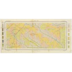
Soil map - Texas, Nacogdoches sheet.
Early color lithographed soil map by Julius Bien & Co. in New York for Department of Agriculture. Legends at side give detail on soil type, etc. They also include int...
- $75 / ≈ €66
Date: New York, 1903
Soil map - Georgia, Fort Valley sheet.
Early color lithographed soil map by Julius Bien & Co. in New York for Department of Agriculture. Legends at side give detail on soil type, etc. They also include in...
- $50 / ≈ €44
Date: New York, 1903
Soil map - Mississippi, McNeill sheet.
Soil map printed by Julius Bien & Co in New York for Department of Agriculture. The map is giving great detail of the area McNeill, Mississippi, in the year 1903. Soi...
- $50 / ≈ €44
Date: New York, 1903
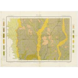
Soil map - Louisiana, Ouachita sheet.
Early color lithographed soil map by Julius Bien & Co. in New York for Department of Agriculture. Legends at side give detail on soil type, etc. They also include int...
- $40 / ≈ €35
Date: New York, 1903
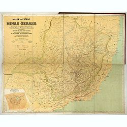
Mappa do estado de Minas Geraes.
Monumental map of the Minas Geraes State, the Brazilian Eldorado, with an inset plan of Belo Horizonte. Scale of 1 : 100 000. Lith. Hartmann-Reichenbach, 1910. Organized ...
- $1000 / ≈ €874
Date: Rio de Janeiro, 1910 -1911
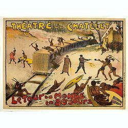
Théâtre du Châtelet. Le Tour du Monde en 80 jours. (The attack of the train).
Theatre poster for "Around the World in Eighty Days by A. Dennery and Jules Verne, for Théâtre du Châtelet, Paris. Printed by : Imprimerie Ch. Wall et Cie, 14 rue...
- $1200 / ≈ €1048
Date: Paris, Imp. Ch. Wall et Cie, ca.1900-1914
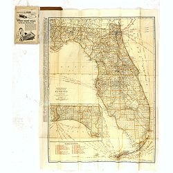
Rand Mc.Nally indexed pocket map Tourits' and Shipper' Guide of Florida. . .
This fine pocket map has on both side a map of Florida. Folding color map (approximately 640 x 495mm) is titled "Rand McNally standard map of Florida" and one h...
Date: Chicago & New York, ca.1915
