Browse Listings in World Maps
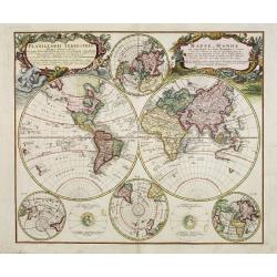
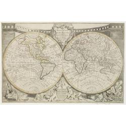
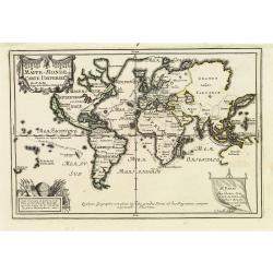
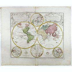
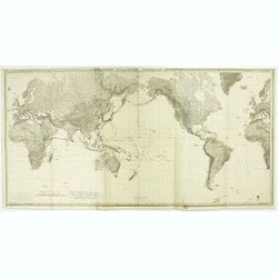
Planiglobii Terrestris - Mappe-Monde...
Word map in double hemisphere. In center two smaller hemispheres of the north and south pole are shown. Two interesting diagrams depict the earth as it would be seen from...
Place & Date: Nuremberg, 1746
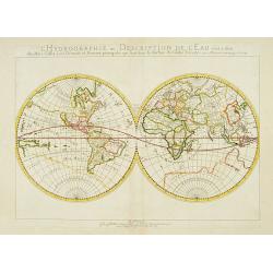
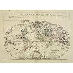
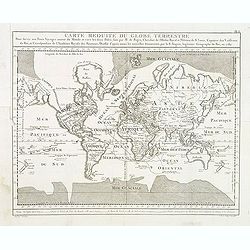
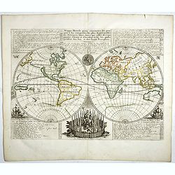
L'Hydrographie ..la Surface du Globe Terrestre.
An unusual double hemisphere hydrological map of the world - the earliest of the world prepared by the great French mapmaker Nicolas Sanson. Of particular interest is the...
- $750 / ≈ €702
Place & Date: Paris, 1652

A new and correct map of the world.
The early eighteen century was one of the most important periods for English cartography. One of the period's most intriguing world maps is this large scale map which off...
- $12000 / ≈ €11229
Place & Date: London 1714

Nova Orbis Tabula in Lucem edita A.F.de Wit.
According to Shirley, De Wit's map is one of the most attractive of its time. The brilliant scenes in the corners combine images of the four seasons, the elements, and th...
Place & Date: Amsterdam, 1680
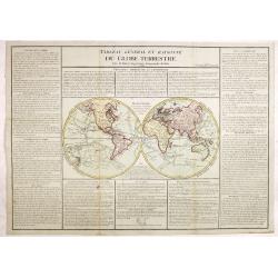
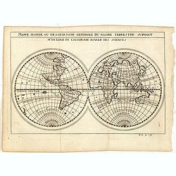
Tableau général et raisonné du Globe Terrestre. . .
Uncommon double hemisphere world map showing the tracks of Cook (1771-73, 1771 and Clarcke (1779). Surrounded by geographical information for each continent along with us...
- $1000 / ≈ €936
Place & Date: Paris 1792
Carta Hydrographica oder Algemeine Welt. . .
World map in Mercator projection. Showing California as an island. In the upper left and right-hand corner two ships. The map is showing the important trade routes.
Place & Date: Augsburg, 1720
![[Titlepage] Nomenclator Ptolemaicus..](/uploads/cache/06436-250x250.jpg)
[Titlepage] Nomenclator Ptolemaicus..
Title page from a Ortelius Atlas part called: Nomenclator , containing a register of place names in antiquity. Letterpress with copper engraved print (60x60mm) of the eas...
- $150 / ≈ €140
Place & Date: Antwerp, 1609
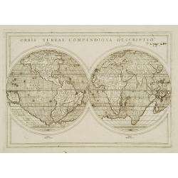
Orbis Terrae compendiosa descriptio.
Modern world map by Rosaccio, consisting of two hemispheres enclosed within a plain border. The engraving is sharp and neat, and is a skilful reduction of Rumold Mercator...
- $1000 / ≈ €936
Place & Date: Venise, 1598/1713

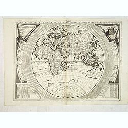
Hemisphaerium Orbis Antiqui cumzonis circulis. . .
A chart showing the eastern hemisphere, including north eastern coast of Australia with, superimposed, climatic zones and planetary details. Surround by most decorative s...
Place & Date: Amsterdam, 1708

Orbis Terrae Compendiosa Descriptio.
Gerard Mercator's great world map of 1569 was condensed into double hemispherical form by his son Rumold. It first appeared in 1587 in Casaubon's edition of Strabo's Geog...
Place & Date: Amsterdam, 1595-1609
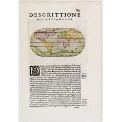
Descittione del Mappamondo.
A fine miniature oval map of the world engraved by Girolamo Porro. It is a reduction of Giovanni Francesco Camocio's superb large map of 1567, one of the last in the long...
- $450 / ≈ €421
Place & Date: Venice, ca.1586
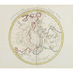
Carte Phisique de la Mer Glaciale Arctique. . .
Very unusual thematic map designed to illustrate the watersheds of the world, after Buache and prepared by J.B.Nolin and published by Monhare for his Atlas Général a l'...
- $300 / ≈ €281
Place & Date: Paris, 1783
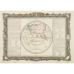
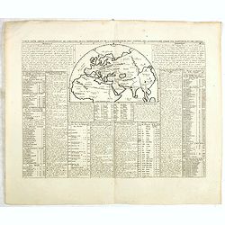
Division Générale et Naturelle de la Terre, Suivant les Anciens.
Decorative chart showing the world as it was known by the ancients.Left and right a box with geographical information about Europe, Asia and Africa.Prepared by Buy de Mor...
Place & Date: Paris, 1762
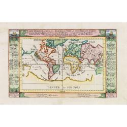
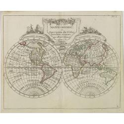
Suite de la Longitude.
Decorative map showing one hemisphere divided into meridians.Left and right a box with further information's about longitude.Prepared by Buy de Mornas, who was a professo...
Place & Date: Paris, 1762
Selling price: $65
Sold in 2013
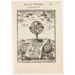
Equateur.
Appealing print centered on an armillary sphere. The latter sits atop a map of the world which clearly shows California as an island. In addition to this curious feature,...
- $200 / ≈ €187
Place & Date: Paris, 1683
![[Manuscript] Mappe - Monde - Novembre 1838.](/uploads/cache/23277-250x250.jpg)
[Manuscript] Mappe - Monde - Novembre 1838.
Fine manuscript double hemisphere world map. With an over sized Australia and no place names on the continents. With the signature of the author Suhardbetween the hemisph...
Place & Date: Paris, 1838
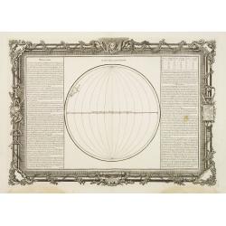
Tableau Sphéroïdal de la Terre ou Mappemonde en deux Hémispères. . .
Large steel engraving presenting the whole World in different projections, namely showing the convexity of the Earth.At the bottom a temperature contour map of the world ...
Place & Date: Paris, 1860
Hémisphère Oriental..
Map of the Eastern Hemisphere, including numerous exploration routes with a notation of important recent discoveries.Australia is partially mapped and then completed into...
- $150 / ≈ €140
Place & Date: Paris, 1786

Nouvelle Mappa Monde.
State 2 of this fine double hemisphere world map, from an unusual perspective, with a "Mer de L'Ouest" or "Sea of the West". Paris is located at the c...
Place & Date: Venice, 1776 - 1784
Mappa Monde ou description du globe terrestre . . .
Double hemisphere world map. California is not an island anymore, but a large Mer de l'Ouest is shown. Delineation between New Holland (Australia) and New Guinea is not y...
- $2200 / ≈ €2059
Place & Date: Venice, 1776 - 1784

Matching set of four wallmaps of America, Asia, America, Europe.
Rare and decorative set of four wall maps published by Louis Charles DESNOS ( fl.1750-1770), including a border with vignettes describing native scenes. Each panel is acc...
Place & Date: Paris, 1760-1761
Mappe-Monde Geo-Hydrographique, ou Description Générale. . .
Large map of the world in two hemispheres, in a stereographic projection (each hemisphere 31.5 cm in diameter). California seems to be connected to the mainland, rather t...
Place & Date: Paris, 1719, but ca. 1741-1745
Il mondo cocsciuto dagli antichi e le laggiori antiche monarchie Persiana, Macedone, Romana . . .
A rare double-page map of the Ancient World. From l'Atlante Storico, Letterario, Biografico, Archeologico. . . with attributions by Giambatista Albrizzi.Lower left a col...
Place & Date: Venice, 1840
Mappe-Monde ou Description du Glôbe Terrestre Assujettie aux Observs Astronoms.
Double hemisphere map with a curious shape for Australia, from Atlas moderne portatif composé de vingt-huit cartes sur toutes les parties du globe terrestre .. A l'usage...
Place & Date: Paris, Prudhomme, Levrault, Debray, 1806
Mappemonde ou globe terestre dressée sur les Nouvelles Observations . . .
Scarce world map with all the major early explorers. Jean Baptiste Louis Clouet (born 1730) was a member of the Academie Royale des Sciences de Rouen and the author of Ge...
Place & Date: Paris, Mondhare, 1787
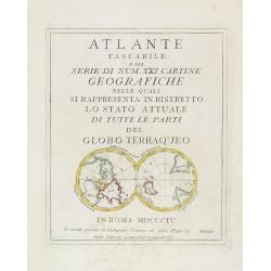
(Title page) Mappamondo sul Piano dell' Equatore. - Atlante Tascabile o sia Serie di Num. XXI Cartine Geografiche nelle quali si. . .
Engraved title page with in lower part a double polar projection (50x95mm.) from the rare atlas Atlante Tascabile o sia Serie di Num. XXI Cartine Geografiche nelle quali ...
- $100 / ≈ €94
Place & Date: Rome, 1823
![Summa philosophiae quadripartita, de rebus dialecticis, moralibus et metaphysicis . . [ With unrecorded world map ]](/uploads/cache/28639-250x250.jpg)
Summa philosophiae quadripartita, de rebus dialecticis, moralibus et metaphysicis . . [ With unrecorded world map ]
On page 107 a finely copper engraved world map (88x84mm.) Paradigma Terrae Plagas 4.ac 12. Ventorum situm indicans., centered on Europe and Africa, with parts of America,...
Place & Date: Leiden, Peter Rigaud, 1626
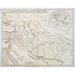
Partie Orientale de la Carte des Anciennes Monarchies. . .
This map depicts the eastern part of the Ancient World, Partie Occidentale de la Carte des Anciennes Monarchies including the Near East, Cyprus, Black Sea, Caspian Sea, I...
Place & Date: Paris, ca. 1800
![[No Tittle] Map of the Easteren Hemisphere.](/uploads/cache/29385-250x250.jpg)
[No Tittle] Map of the Easteren Hemisphere.
Nice small map of eastern hemisphere by Johannes Walch in his rare Allgemeiner Atlas Nach den bewährsten Hülfsmitteln und astronomischen Ortsbestimungen…, edition of ...
- $120 / ≈ €112
Place & Date: Augsburg, 1812

Secunda etas mundi. Folium XIII.
Schedel's world map was based on the cartographic system of Claudius Ptolemy, the great second-century AD geographer whose scholarship formed the foundation for map produ...
Place & Date: Nuremberg, 12 July 1493
Chikyu Bankoku sankai yochi zenzu setsu. / Sekisui Cho Harutaka. (Map and description of geography of all the countries of the globe).
Reduced version of the famous map "Kaisei chikyu bankoku zenzu" by Sekisui Nagakubo (1717-1801) published ca. 1785, still based on the one by Matteo Ricci. Incl...
- $3500 / ≈ €3275
Place & Date: Tokyo, 1850

Nansenbushu bankoku shoka no zu.
This map is a great example of Japanese world maps representing Buddhist cosmology with real-world cartography. It is the earliest one and - therefore - the prototype for...
Place & Date: Kyoto, (Hoei 7 = Year of the Tiger) 1710
Mappe-Monde ou carte Universelle. . .
Uncommon world map in Mercator's projection, which first appeared in De Fer's Atlas Curieux.Showing California as an island. Engraved by C.Inselin.Shows the explorer's ro...
Place & Date: Paris, 1705
Carte Reduite du globe Terrestre. . .
Fine world map in a Mercator projection. From Voyages autour du monde et vers les deux pôles par terre et par mer.. by Pierre Marie François vicomte de Pages (1748-1793...
Place & Date: Paris, ca 1782
Mappamondo.
Charming world map in double hemisphere from the rare atlas Atlante Tascabile o sia Serie di Num. XXI Cartine Geografiche nelle quali si rappresenta in ristretto lo Stato...
- $250 / ≈ €234
Place & Date: Rome, 1823
![[Printed on silk] Nieuw Wassende Graaden Paskaart Vertoonende alle de bekende Zeekusten en Landen op den geheelen Aard Boodem of Werelt door Gerard van Keulen. . .](/uploads/cache/31640-250x250.jpg)
[Printed on silk] Nieuw Wassende Graaden Paskaart Vertoonende alle de bekende Zeekusten en Landen op den geheelen Aard Boodem of Werelt door Gerard van Keulen. . .
A very scarce and beautiful chart on Mercator's projection printed on silk. With the name of Gerard van Keulen and the privilege. The map shows great interior detail, inc...
Place & Date: Amsterdam, 1728
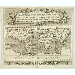
Tabula geographico-hydrographica motus Tom II p.132.
World map depicting ocean currents, volcanoes and deep-sea chasms. The continents are void of political detail and only major lakes, rivers and volcanoes are shown. There...
- $2000 / ≈ €1871
Place & Date: Nuremberg, 1696
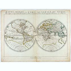
Mappe-Monde, ou Carte Generale du Monde: Dessignée en deux plans Hemispheres Par le Sr. Sanson d'Abbeville, Geographe ordinaire de sa Majesté.
First state of Sanson's first map of the World. Sanson's first world maps, dated 1651 and 1652, were issued separately and then in collections of maps. The map is one of ...
- $1500 / ≈ €1404
Place & Date: Paris, 1651

Nouvelle et exacte description du globe terrestre reveue corrigée et augmente´e suivant les derniéres relations des Anglais et Hollandois. Par Guillaume Blaeu 1645.
Extremely rare and decorative "carte a figures" world map published by Anthoine de Fer. The double hemisphere world map is surrounded by constellations of the A...
Place & Date: Paris, 1645
Planisfero del Mondo Vecchio. . .
A decorative map of the Eastern hemisphere includes Abel Tasman's discoveries in Australia. The decorative borders include coordinates and descriptions of signs of the zo...
Place & Date: Venice, 1691
Selling price: $1800
Sold in 2015
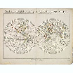
Mappe-Monde, ou Carte Generale du Monde: Dessignée en deux plans Hemispheres Par le Sr. Sanson d'Abbeville, Geographe ordinaire de sa Majesté.
Sanson's first world maps, dated 1651 and 1652, were issued separately and then in collections of mapsThe map is one of the first to distinguish the Great Lakes, all five...
Place & Date: Paris, 1651
Karta öfver Jord-Globen (World map)
An very rare double hemisphere world map. This is an heavenly updated version of his map of 1817 and is now dated 1848, Australia with new nomenclature and the old title ...
- $250 / ≈ €234
Place & Date: A. Wiborgs förlag, Stockholm, ca. 1848

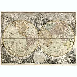
Le globe terrestre representé en deux plans-hemispheres, Dressé sur la Projection de Mr. De la Hyre...
“This splendid GlobeTerrestre originally published by J.B. Nolin is one of the finest large-scale world maps to be produced and is a fitting bridge between the geograph...
Place & Date: Paris, c. 1780
Mappemonde sur la projection de Mercator Dressee par Mr Lapie, Lieut. Colonel. et Mr Lapie, fils capitaine d'Etat major, Paris 1832.
Very detailed world map with Australia in the center and prepared by Pierre M. Lapie (fl. 1779 - 1850) and his son Alexandre Emile Lapie (fl. 1809 - 1850).Engraved by Lal...
- $450 / ≈ €421
Place & Date: Paris, 1832
![[No title - Daniel's Dream map]](/uploads/cache/34784-250x250.jpg)
[No title - Daniel's Dream map]
Wood block print engraved by the famous engravers Jost Amman and Virgil Solis - with their initials in lower bottom of the map. This somewhat curious map of Europe, Afric...
Place & Date: Cologne, ca. 1564
![[No title] 'Daniel's Dream Map' or 'Wittenberg World Map'.](/uploads/cache/34785-250x250.jpg)
[No title] 'Daniel's Dream Map' or 'Wittenberg World Map'.
Wood block print engraved by the famous engravers Jost Amman and Virgil Solis - with their initials in lower bottom of the map. This somewhat curious map of Europe, Afric...
Place & Date: Cologne, ca. 1564
Mappemonde Dressée sur les Relations les Plus Nouvelles et les plus approuvées assujeties aux Obserations de Mrs. De L'Académie Royale des Sciences.
Dated 1761, this state is unknown. "Desnos' includes a fine combination of up to date cartographic information and the routes of important 18th century voyages of ex...
- $3000 / ≈ €2807
Place & Date: Paris, 1789
Carte pour servir à l'intelligence de l'histoire de la chronologie et de la géographie des empires des Assiriens, des Perses, des Egyptiens et des Chinois.
Interesting sheet with a map of the classical world showing the empires of the Assyrians, Persians, Egyptians and Chinese, with descriptive French text, from Chatelain's ...
Place & Date: Amsterdam, 1720
Abbozzo della mappa dei viaggi di Marco Polo nella sala dello Scudo del Palazzo ducale di Venezia.
Rare map showing the travels of Marco Polo, taken from "Sulle antiche mappe idro-geografiche lavorate in Venezia: Commentario.", by Placido Zurla (1769-1834), p...
Place & Date: Venice, 1818

Nova Totius Terrarum Orbis Geographica..
The first of four states of the map. French text on verso. One of the most beautiful world maps ever engraved and one of the most influential in promulgating the Californ...
Place & Date: Amsterdam, 1630-1633
The world, including the discoveries made by Capt. Cook.
Uncommon double-hemisphere world map depicting the voyages and discoveries of Captain James Cook. There are numerous notations throughout and the tracks of Cook's three v...
- $1000 / ≈ €936
Place & Date: London, 1781
Mappe monde ou description generale du globe terrestre suivant Mr.de Lisle de l'academie Royale des sciences.
Scarce small map of Europe based on cartography of Guillaume Delisle (. Published in "Nouveau traité de geographie par M**** ", published by La veuve Lottin &a...
- $200 / ≈ €187
Place & Date: Paris, 1752
A Chart of the World on Mercator's Projection Shewing the Principal Ocean Steam Routes, the Submarine Telegraphs &c.
Charming, folding world map on Mercator's projection showing extensive steam routes and underground and undersea telegraph cables. The map is annotated in blue and red wi...
Place & Date: London, ca. 1890
Carte pour servir a L'Histoire Philosophique et Politique..
Showing the eastern hemisphere, including Australia. With inset map of India and Sri Lanka in the Indian Ocean.The focus of the chart is European trade and commerce with ...
- $150 / ≈ €140
Place & Date: Paris, 1780
Il Mappamondo o sia Descrizione Generale del Globo Ridotto..
Attractive Italian map presented on Mercator's projection and featuring the voyages of Cook and Bougainville. Greenland is shown connected to North America and Alaska is ...
- $750 / ≈ €702
Place & Date: Venice, 1774
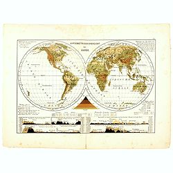
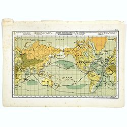
Hypsometrisch Overzicht der Aarde.
One of the earliest thematic world maps published in the Netherlands from "Atlas der natuurkundige aardrijkskunde. . .". prepared by Nicolaas Wilhelmus Posthumu...
- $50 / ≈ €47
Place & Date: Amsterdam, C.L. Brinkman, 1883
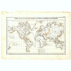
Kaart, voorstellende de Seculaire Rijzingen en Dalingen van den Bodem, alsmede de Vulkamen.
One of the earliest thematic world maps published in the Netherlands from "Atlas der natuurkundige aardrijkskunde. . .". prepared by Nicolaas Wilhelmus Posthumu...
- $35 / ≈ €33
Place & Date: Amsterdam, C.L. Brinkman, 1883
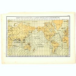
Kaart der Isorachiën of Lijnen van Gelijke Vloedbeweging.
One of the earliest thematic world maps published in the Netherlands from "Atlas der natuurkundige aardrijkskunde. . .". prepared by Nicolaas Wilhelmus Posthumu...
- $35 / ≈ €33
Place & Date: Amsterdam, C.L. Brinkman, 1883
Kaart der Oceanische Stroomgebieden.
One of the earliest thematic maps published in the Netherlands from "Atlas der natuurkundige aardrijkskunde. . .". prepared by Nicolaas Wilhelmus Posthumus. The...
- $35 / ≈ €33
Place & Date: Amsterdam, C.L. Brinkman, 1883
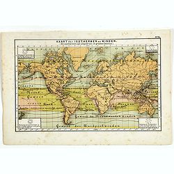
Kaart der Oceanische Stroomgebieden.
One of the earliest thematic maps published in the Netherlands from "Atlas der natuurkundige aardrijkskunde. . .". prepared by Nicolaas Wilhelmus Posthumus. The...
- $35 / ≈ €33
Place & Date: Amsterdam, C.L. Brinkman, 1883
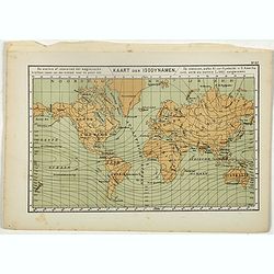
Kaart der Isodynamen.
One of the earliest thematic maps published in the Netherlands from "Atlas der natuurkundige aardrijkskunde. . .". prepared by Nicolaas Wilhelmus Posthumus. The...
- $35 / ≈ €33
Place & Date: Amsterdam, C.L. Brinkman, 1883
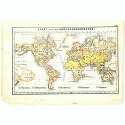
Kaart van de Hoofdgodsdiensten.
One of the earliest thematic world maps published in the Netherlands from "Atlas der natuurkundige aardrijkskunde. . .". prepared by Nicolaas Wilhelmus Posthumu...
- $35 / ≈ €33
Place & Date: Amsterdam, C.L. Brinkman, 1883
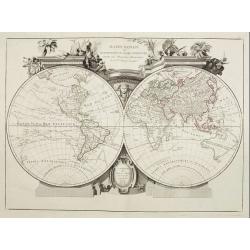
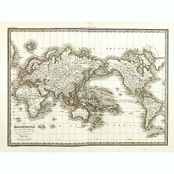
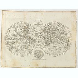
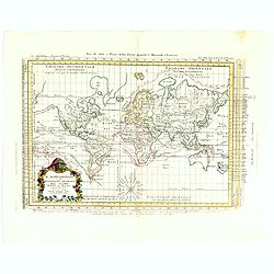
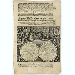
Planiglobii Terrestris Mappa Universalis.. - Mappe-Monde qui represente les deux Hemispheres. . .
Word map in double hemisphere. In center two smaller hemispheres of the north and south pole are shown. Two interesting diagrams depict the earth as it would be seen from...
- $1750 / ≈ €1638
Place & Date: Nuremberg, 1746
Mappe-Monde pour connoitre les progres & les conquestes..
Unusual double hemisphere map with California as an Island. Dutch text describes the expeditions and colonial possessions of the Dutch East India Company. The map origina...
Place & Date: Amsterdam, 1729
Carte pour servir à l'intelligence de l'histoire de la chronologie et de la géographie des empires des Assiriens, des Perses, des Egyptiens et des Chinois.
Interesting sheet with a map of the classical world showing the empires of the Assyrians, Persians, Egyptians and Chinese, with descriptive French text, from Chatelain's ...
- $75 / ≈ €70
Place & Date: Amsterdam, 1720
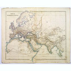
Orbis Veteribus Notus.
A detailed steel engraved map of the ancient world, stretching from Europe eastwards to the Black Sea and beyond, southwards through northern Africa, Arabia, India, and S...
Place & Date: London, 1839
![Die Obere oder Nordliche Halbkugel der Erde auf den Horizont von Wien, Sterographisch Entworfen ... [together with] Die Untere oder Sudliche Halbkugel der Erde auf den Horizont von Wien, Stereographisch ...](/uploads/cache/39377-250x250.jpg)
Die Obere oder Nordliche Halbkugel der Erde auf den Horizont von Wien, Sterographisch Entworfen ... [together with] Die Untere oder Sudliche Halbkugel der Erde auf den Horizont von Wien, Stereographisch ...
A set of two uncommon large format maps of the Northern and Southern Hemisphere, based upon the work of Johann Anton Ecker (1755-1820). First published in 1794, this is t...
- $2000 / ≈ €1871
Place & Date: Vienna, Phil. Jos Schalbacher, 1800

Nova Totius Terrarum Orbis Geographica ac Hydrographica Tabula.
A beautifully decorative world map taken from the 'English Atlas' by Moses Pitt and Steven Swart, based on an earlier engraved world map by Pieter van den Keere ca. 1630,...
Place & Date: Oxford, 1680
Description de nouveau pasage vers le zud.... together with an untitled map of Port Desire (today's Puerto Deseado, Argentina)
Rare double hemispherical world map showing the track round the world by Le Maire and Schouten in 1615-1617. Continents are marked in outline and no southern regions are ...
- $1500 / ≈ €1404
Place & Date: Frankfurt, M.Merian, 1631

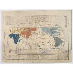
World Flight Routes (all in Japanese).
A large very decorative Japanese world map published as sugoroku (a Japanese game which might be compared to backgammon) published as a supplement to the 1930 New Year’...
Place & Date: Osaka, 1930
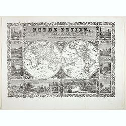
Monde Entier, Par J. Henry Dressine et Ecrit Chez L' Auteur Par A. Clement.
Decorative uncommon 19th century double hemisphere map of the word with ten vignettes surrounding the map. The vignettes show a naval battle, and a land battle with a com...
- $300 / ≈ €281
Place & Date: Paris, 1834
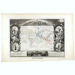
Planisphère.
One of the last decorative maps of the area. In side panels representations of the four seasons. In original out line color, from his "Atlas Universel Illustré"...
- $175 / ≈ €164
Place & Date: Paris, 1845-1860
![[Set of five maps] Carte Générale de la Terre ou Mappe Monde](/uploads/cache/41145X-250x250.jpg)
[Set of five maps] Carte Générale de la Terre ou Mappe Monde
Rare and decorative set of five wall maps of the world and the four continents, prepared by Clouet, in very fine bright contemporary coloring. Each map ca. 965 x 1230 mm ...
Place & Date: Paris and Cadiz, Mondhare, 1785-1793

(World map). Americus Vespucio novo te Duce Ducta Freto Ambivi Meritoqs Vocor.
Manuscript world map showing the American and African continent and the southern parts of Asia. In the Indian Ocean a large depiction of Amerigo Vespucci 1454 – 1512) o...
Place & Date: Italy, ca. 1954
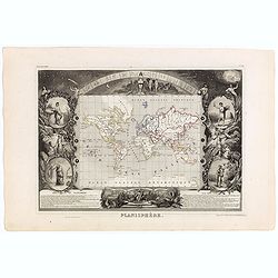
Planisphère.
One of the last decorative maps of the area. In side panels representations of the four seasons. In original o.l. color, from his "Atlas Universel Illustré". T...
Place & Date: Paris, A. Combette, 1852
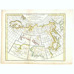
Carte des parties Nord et Est de L'Asie. . .
Five maps on one sheet, showing the Northern Russian territories in Europe and Asia, including the western coastline from Siberia, with Japan and Korea with the island of...
- $100 / ≈ €94
Place & Date: Paris, 1779
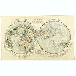
The Earth projected on the horizon of London.
Double hemisphere orientated on the north and south poles.
- $150 / ≈ €140
Place & Date: London, 1850
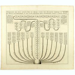
Succession des plus anciens Rois du monde . . .
Showing successions of the oldest kings of the world, with a globe in lower part of the print. Copper engraved plate from "Atlas Historique". Zacharie Chatelain...
- $45 / ≈ €42
Place & Date: Amsterdam, 1720
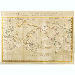
Carte Générale de Voyage Pittoresque Autour du Monde.
A map of the world centered on the Pacific Ocean. Engraved by Ambroise Tardieu.Jules Sébastien César Dumont d'Urville (1790 – 1842) was a French explorer, naval offic...
- $125 / ≈ €117
Place & Date: Paris, ca. 1840
Planisphère terrestre.
A huge (2 meters) world map representing Asia and America in the center, Europe and Africa at left and right hand of the map. Published by the Service hydrographique in 1...
- $800 / ≈ €749
Place & Date: Paris, Service hydrographique, 1902-1914