Browse Listings

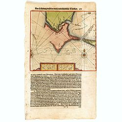
Die Zyp / La Zype.
A miniature map showing the polder of De Zype. Title cartouche in the upper side.First published in 1598 in his Caert-Thresoor, the plates were executed by the most famou...
Date: Amsterdam / Frankfurt, 1609
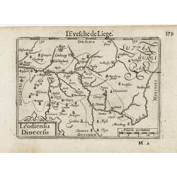
Leodiensis Dioecesis.
A miniature map of the southern part of Belgium centered on Liege. The title cartouche on the lower left corner.First published in 1598 in his Caert-Thresoor, the plates ...
- $75 / ≈ €65
Date: Amsterdam / Frankfurt, 1609
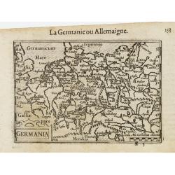
Germania.
A miniature map of Germany. The title cartouche on the lower left corner. First published in 1598 in his Caert-Thresoor, the plates were executed by the most famous engra...
- $75 / ≈ €65
Date: Amsterdam/Frankfurt, 1609

Biturigum.
A miniature map of the Berry. Fine cartouche in the upper left corner.First published in 1598 in his Caert-Thresoor, the plates were executed by the most famous engravers...
Date: Amsterdam/Frankfurt 1609
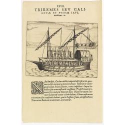
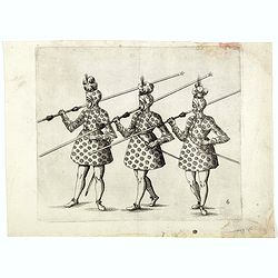
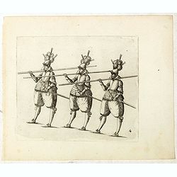
XXVII. Triremes seu Galiottae et Fustae Iavenenfium. 21. ( A typical Javanese man-of-war ship)
A typical Javanese man-of-war ship. The Javanese call their man-of-war ships, Cathurs. The slaves are all seated below deck and do the rowing with oars, while the warrior...
- $150 / ≈ €130
Date: Frankfurt, 1609
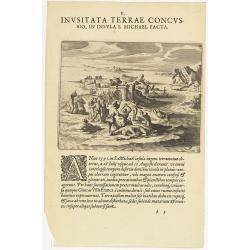
V. Inusitata Terrae Concussio, in Insula S. Michael Facta.
Showing the Vila Franca earthquake on 26 July 1591Theodore de Bry, a German engraver and book dealer, began a compilation of early voyages in 1590 and had published six p...
- $75 / ≈ €65
Date: Frankfurt, 1609
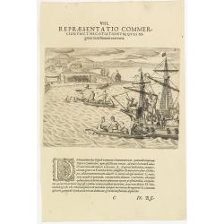
VIII. Repraesentatio Commerciorum et Negotiationum, Quas Nigritae cum Batauis exercent.
Locals from Gold Coast trying to sell items to the crew of a Dutch vessel. Theodore de Bry, a German engraver and book dealer, began a compilation of early voyages in 159...
- $100 / ≈ €87
Date: Frankfurt, 1609
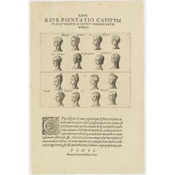
XXVI. Repraesentatio Capitum Praecipuarum Aliquot Personarum in Benyn.
Different types from Benin, in West Africa.Theodore de Bry, a German engraver and book dealer, began a compilation of early voyages in 1590 and had published six parts at...
- $75 / ≈ €65
Date: Frankfurt, 1609
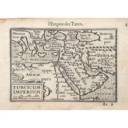
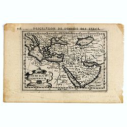
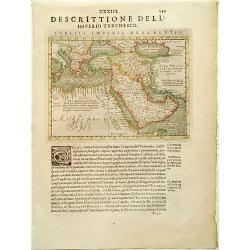
Turcicum Imperium / Empire Turc.
A miniature map of the Arabian peninsula, centered on Jerusalem. Title cartouche on the lower left corner.First published in 1598 in his Caert-Thresoor, the plates were e...
Date: Amsterdam/Frankfurt 1609
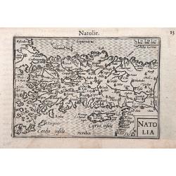
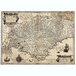
Natolia.
A miniature map of the Arabian peninsula, including Cyprus. The title cartouche on the lower right corner.First published in 1598 in his Caert-Thresoor, the plates were e...
- $200 / ≈ €174
Date: Amsterdam / Frankfurt, 1609
![[Description de la Figure de la ville de Gammelamme - Description du N° 15]](/uploads/cache/43504-250x250.jpg)
[Description de la Figure de la ville de Gammelamme - Description du N° 15]
View of the town of Gammelamme [Gamalama] on Ternate, where the Dutch established a trading post. Text engraving from "Premier livre de l'histoire de la navigation a...
- $50 / ≈ €43
Date: Amsterdam, Cornille Nicolas, 1609
![[Title page] Germaniae Tabule Geographicae ...](/uploads/cache/43267-250x250.jpg)
[Title page] Germaniae Tabule Geographicae ...
This is the title page to the volume of the atlas devoted to maps of Germany. According to Shirley the "early sectional parts of his "Atlas" each had Manne...
Date: Amsterdam, 1585-c.1610
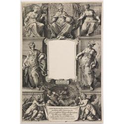
(Title page) Principum Christianorum Stemmata.
Uncommon title page. From Antonio Albizzi, "Principum Christianorum Stemmata ab Antonio Albizio Nobili Florentino collecta: et Cum brevibus ejusdem notationibus ex A...
- $200 / ≈ €174
Date: Strasbourg, 1610
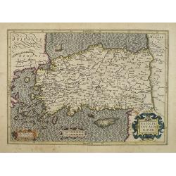
Natoliae Sive Asia Minor.
Map of Turkey, also depicting Cyprus.
- $750 / ≈ €651
Date: Amsterdam, 1610
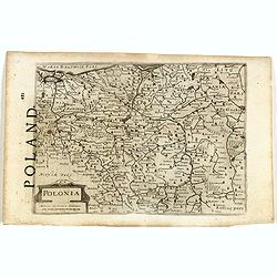
Polonia. (With text page)
Early map of Poland (168x250mm.) printed on a text page, together with another giving a description of the region in English.
- $150 / ≈ €130
Date: Amsterdam, 1612
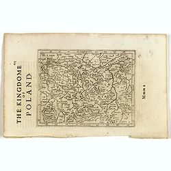
Polonia et Silesia. (With text page)
Early map of Poland. With English title above the map and an description of the region in English on verso.
- $250 / ≈ €217
Date: Amsterdam, 1612
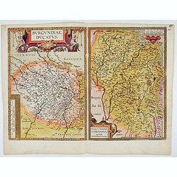
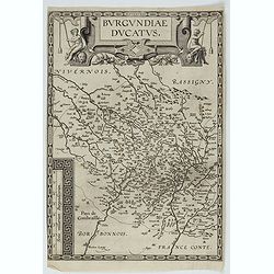
Burgundiae Ducatus. Burgundiae Comitatus.
Separately issued map of Burgundy area. Two maps of Burgundy region on a plate. Separately published map, without text on the verso. Second state with the date 1597 remov...
Date: Antwerp, after 1612
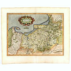
Prussia .
Important early map showing coast of Baltic Sea in Prussia, today Poland, prepared by the German cartographer Gaspher Henneberg of Erlich. Embellished with a large strapw...
Date: Amsterdam, 1612

Limburgensis Ducatus Tabula Nova.
Map of Limburg, prepared by the Antwerp expert in law and mathematics Aegidius Martini. After 1600 Jan Baptist Vrients acquired the stock and the plates of Ortelius' Thea...
Date: Antwerp, 1606-1612
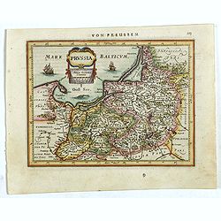
Prussia .
An early map of northern Poland from the "Atlas Minor" (Gerhard Mercator / Jodocus Hondius). Extends from Memel to Torun and the Narew River. With two sailing s...
- $300 / ≈ €260
Date: Amsterdam, 1612
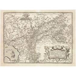
Artois. Atrebatum Regionis Vera Descripto.
Prepared by Jacob Surhon who made a manuscript map of Artois for which he received 36 Livres from Charles V in 1554. For security reasons the map was not published. Only ...
- $500 / ≈ €434
Date: Antwerp, after 1612
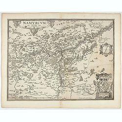
Namurcum Comitatus.
Prepared by Jacques Surhon in 1555. His manuscript map was for security reason not published. Only in 1579, when Antwerp was independent for a short time, Ortelius used a...
- $500 / ≈ €434
Date: Antwerp, after 1612

Flandria.
Very decorative, egg-shaped map. This is the last and very rare third state with the signature Theodorus Galle. The fortifications along the Scheldt River are added and t...
- $1000 / ≈ €868
Date: Antwerp, after 1612
Gelriae, Cliviae, Finitimorumque Locorum Verissima Descriptio.
From the very rare Galle edition of the Ortelius Atlas, published after 1612. Fine map of Geldria and Limburg, prepared by Christian s'Grooten. Very fine title cartouche ...
Date: Antwerp, after 1612
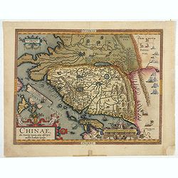
Chinae, olim Sinarum Regionis, nova descriptio. Auctore Ludovico Georgio.
The first map of China ever to appear in a Western atlas, west to the top. When this map appeared, it was by far the most accurate one of China.The map is based on a manu...
- $5500 / ≈ €4773
Date: Antwerp, 1608 /1612

Hydrograhica descriptio
This very rare chart is important as the first printed sea chart of the Mediterranean coast of Spain, Gibraltar, also depicting the northern coast of Marocco.Willem Bar...
Date: Amsterdam, W.Blaeu, 1612
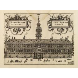
Domus Hansae Teutonicae / Sacri Romani Imperii. (Antwerp townhall)
From Ludovico Guicciardini.'s description of the Netherlands "Beschrijvinghe van alle de Nederlanden anderssins ghenoemt Neder-Duytslandt", published by Willem ...
- $100 / ≈ €87
Date: Amsterdam, 1612

Tartariae sive Magni Chami Imperium.
This is a very early depiction of the northern Pacific, with the first mapping of Northwest Coast of America and probably the first map to name California 'C. Califormio...
- $2500 / ≈ €2169
Date: Antwerp, c. 1608-1612
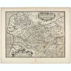
Burgundiae Ducatus.
Map of Burgundy region without text on the verso. Second state with the date 1597 removed from the title cartouche. This is the rarest Burgundy map of the four that Ortel...
- $500 / ≈ €434
Date: Antwerp, after 1612
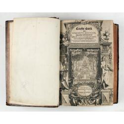
Cruydt-Boeck van Remberus Dodonaeus. . .
Scarce, the last edition of Dodoens' Cruydt-Boeck, one of the most influential and important botanical works of the 16th and 17th centuries. With richly engraved frontisp...
Date: Leyden, 1612

DELFT. Delphium urbs Hollandiae cultissima. . .
A bird's-eye view of the town of Delft. From the first Dutch translation of Guicciardini's description of the Netherlands. In this town-plan, three buildings, still domin...
Date: Amsterdam, 1612
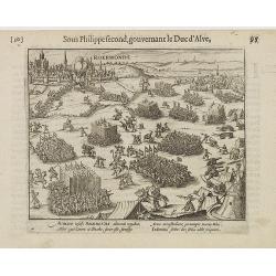
Auriaco infaelix Roermonda. . .
Showing the siege in May 1572 of Roermond.
- $100 / ≈ €87
Date: Amsterdam, 1612

Sardinia / Sicilia.. / Corfu / Zerbi.. / Elba / Malta. . .
Six very fine and early maps on one sheet. Including the islands of Sicily, Corfu, Sardinia, Zerbi (Djerba), Elba and Malta.The map of Malta has a sinking ship at Cala di...
Date: Antwerp, 1570-1612

Ruremunda Gelriae opp.
A bird's eye town-plan of the town of Roermond. From the first Dutch translation of Guicciardini's description of the Netherlands.
Date: Amsterdam, 1612
![[Title page for] Galliae tabule geographicae . . .](/uploads/cache/47941-250x250.jpg)
[Title page for] Galliae tabule geographicae . . .
Very fine title page by Gerard Mercator, composed of an elaborate strapwork design with the portrait of a King at the top.
Date: Amsterdam, 1613
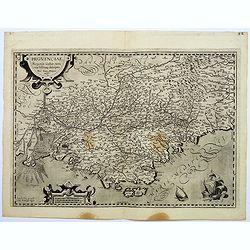
Provinciae, Regionis Galliae, vera exactissimaq. descriptio. Provence Petro Ioanne Bomparioo auctore.
A finely engraved map of the Province prepared by Pierre-Jean de Bompar who published a single sheet map of the Province in 1591. Title cartouche in the upper left-hand c...
- $500 / ≈ €434
Date: Amsterdam, 1613
![[Title page colored by Georg Mack Jr. to : Hortus Eystettensis, Sive Diligens et Accurata Omnium Plantarum, Florum, Stirpium,. . .]](/uploads/cache/39343-250x250.jpg)
[Title page colored by Georg Mack Jr. to : Hortus Eystettensis, Sive Diligens et Accurata Omnium Plantarum, Florum, Stirpium,. . .]
Title page to the first edition, one of about 300 copies printed, from one of the largest and most magnificent of the great flower books, depicting more than 1000 flowers...
Date: Nuremberg, ca 1613
![Description de tovts les Pays-Bas, autrement appellez, la Germanie Inferieure, ov Basse Allemagne / par Messire Loys Gvicciardin [...]](/uploads/cache/48781-250x250.jpg)
Description de tovts les Pays-Bas, autrement appellez, la Germanie Inferieure, ov Basse Allemagne / par Messire Loys Gvicciardin [...]
Fine early edition of the French oblong edition of this famous description of the Low Countries. For the French edition most plates are newly engraved by Petrus Kaerius.....
- $3500 / ≈ €3037
Date: Arnhem, Janssonius, J.,1613
![[Titlepage] Italiae, Sclavoniae, et Graeciae tabula geographice..](/uploads/cache/21220-250x250.jpg)
[Titlepage] Italiae, Sclavoniae, et Graeciae tabula geographice..
The text in this decorative title page from the atlas by Mercator is enclosed in an architectural framework engraved with cherubs, garlands and an eagle.Read more about t...
- $220 / ≈ €191
Date: Amsterdam, 1613
![[Titlepage] Galliae tabulae geographicae..](/uploads/cache/21219-250x250.jpg)
[Titlepage] Galliae tabulae geographicae..
Decorative title page from the atlas by Mercator, surrounded with strapwork designs, garlands, fruit, birds and a portrait of a king.Read more about title pages. [+]
- $220 / ≈ €191
Date: Amsterdam, 1613
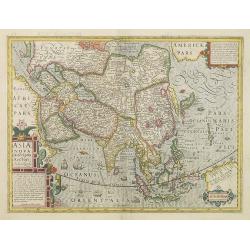
Asiae Nova Descriptio. . .
Several sources appear to have been used in the compilation of this map, including the Portuguese Jesuits Luis Teixeira (1595) for Japan, and Luis Jorgede Barbuda (1584) ...
- $3000 / ≈ €2603
Date: Amsterdam, 1613

Nova et accurata Foederatarum Orovinciarum Inferioris Germaniae descriptio… 1615 P.Kaerius.
The oldest know map of the Dutch Republik. The extremely rare 1615 editiion of the map of the Netherlands. The map is better from from the Cloppenburg editions of the At...
- $1500 / ≈ €1302
Date: J.Janssoius, Arnhem, 1615
De Christiana expeditione apud Sinas suscepta ab Societate Jesu, ex P. Matthaei Ricci.
Very rare first edition of the most influential Western description of China since the 13th-century account by Marco Polo. Printed in Latin with an engraved title page in...
Date: Augustæ Vind. (Augsburg), C. Mangium, 1615
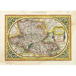
Comitatus Hannonia.
Detailed map of the Belgium province Hainault or Henegouwen. Including the towns of Mons, Geraadsbergen, etc.Uncommon and decorative oval map in a rectangular frame, the ...
- $100 / ≈ €87
Date: Amsterdam, 1616
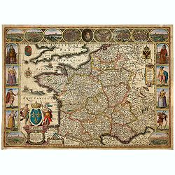
Gallia. Nova Galliae descriptio . . .
Very rare and early map of France with figures on three sides with views of cities, portraits (Henri IV and Marie de Medicis) and costumes. The map was directly influence...
Date: Amsterdam, 1616

Nieuw Nederlandtsch Caertboeck. Waer in volkomentlijcker als oyt te voren vertoont werden de XVII. Nederlanden.
Rare first edition of this atlas of the provinces of the Netherlands, Belgium and Luxemburg. Engraved title page, with : "Gedruckt t' Amsterdam by Abraham Goos Plaet...
Date: Amsterdam, 1616
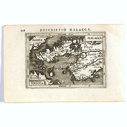
Malacca.
FIRST IMPRINT FROM THE NEWLY ENGRAVED PLATES IN 1616. - A rare miniature map of Malacca, Borneo, part of Sumatra . Latin text on verso.First published in 1598 in his Caer...
Date: Amsterdam, J. Hondius, 1616
Aufzug des durchleuchtigsten hochgebornen Fürsten und Herren, Herren Friderichen Pfaltzgrafen bey Rhein.. .
Finely executed engraving by Matthäus Merian, taken from "Aufzug des durchleuchtigsten hochgebornen Fürsten und Herren, Herren Friderichen Pfaltzgrafen bey Rhein. ...
Date: Hulsen, Stuttgart, 1616
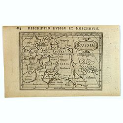
Russia.
Centered on Moscow, with the southern reaches of the map showing Persia, Armenia and Tashkent, the Black and Caspian Seas, and northward to Lapland and the frozen arctic ...
- $200 / ≈ €174
Date: Amsterdam, 1616
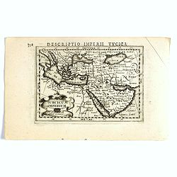
Turcicum Imperium.
FIRST IMPRINT FROM THE NEWLY ENGRAVED PLATES IN 1616. - A rare miniature map of the Arabian Peninsular. Title cartouche on the lower left corner.First published in 1598 i...
- $500 / ≈ €434
Date: Amsterdam, J. Hondius, 1616
Aufzug des durchleuchtigsten hochgebornen Fürsten und Herren, Herren Friderichen Pfaltzgrafen bey Rhein.. .
Finely executed engraving by Matthäus Merian, taken from "Aufzug des durchleuchtigsten hochgebornen Fürsten und Herren, Herren Friderichen Pfaltzgrafen bey Rhein. ...
- $100 / ≈ €87
Date: Hulsen, Stuttgart, 1616
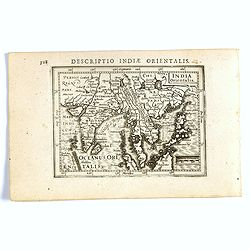
India Orientalis.
FIRST IMPRINT FROM THE NEWLY ENGRAVED PLATES IN 1616. - A rare miniature map of the East Indies.First published in 1598 in his Caert-Thresoor, the plates were executed by...
Date: Amsterdam, J. Hondius, 1616
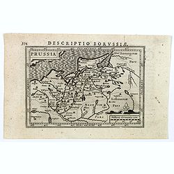
Descriptio Borussiae.
Fine miniature map of Prussia, now-a-day Poland. Bertius was a Flemish theologian, historian, geographer and cartographer. This little copperplate gem was engraved by van...
- $150 / ≈ €130
Date: Amsterdam, 1616
Turicum imperium.
FIRST IMPRINT FROM THE NEWLY ENGRAVED PLATES IN 1616. - A rare miniature map of the Ottoman empire with Turkey and the Arabian Peninsular. Title cartouche on the lower le...
Date: Amsterdam, J. Hondius, 1616
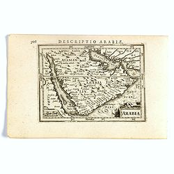
Arabia.
FIRST IMPRINT FROM THE NEWLY ENGRAVED PLATES IN 1616. - A rare miniature map of the Arabian Peninsular. Title cartouche on the lower left corner.First published in 1598 i...
Date: Amsterdam, J. Hondius, 1616
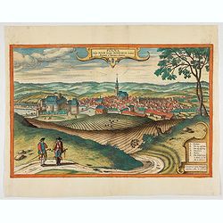
Polna vulgo Polm insign : Bohemia. . .
This is a view of Polna from the southwest, looking across the Bohemian-Moravian Highlands from a slightly elevated viewpoint. In addition to the parish church (D) in the...
Date: Cologne, 1617
Znaymum vulgo Znaym, Moraviae Civitas Primaria.
Rare bird's-eye view of Znojmo (Znaim) Key to 12 locations.COMMENTARY BY BRAUN: "This is a beautiful and wealthy city in Moravia, situated on the border to Austria o...
- $750 / ≈ €651
Date: Cologne, 1618
![Prospectus amoeniss. vallis Oeniponticae una cum antro in altissima et praeruptissima rupe Imp. Maximiliani primi. [on sheet with:] Schlosberg. die Clause in Alpibus Tirolensibus. ..](/uploads/cache/47903-250x250.jpg)
Prospectus amoeniss. vallis Oeniponticae una cum antro in altissima et praeruptissima rupe Imp. Maximiliani primi. [on sheet with:] Schlosberg. die Clause in Alpibus Tirolensibus. ..
Three views by Braun and Hogenberg: View of the Innvalley; view of the "Schlosberg" and a view of a monument for the emperor Carolus V.CAPTION: Prospect of the ...
- $350 / ≈ €304
Date: Cologne, 1618

Frisia occidentalis.
A rare separately published carte-a-figures of Friesland by Geelkercken in its first state. The title and the coats of arms of the eleven Frisian towns appear in the cent...
Date: [Leeuwarden], Dierick Albertsen, 1618
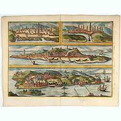
Casablanca (Anfa) - Azemmour (Azamor) - Diu - Old Goa (Velha Goa)
Four fine coastal views of these harbors cities which were important to Portuguese trade. Goa and Diu on the western coast of India, together with Anfa (Casablanc) and Az...
- $450 / ≈ €390
Date: Cologne, 1618
!['T Derde deel van 't Licht der zee-vaert, inhoudende de beschryvinghe der zeecusten van de Middelandtsche Zee /, By een vergaedert ende in't licht ghebracht door Willem Janssen. [Blaeu sea atlas].](/uploads/cache/49048-250x250.jpg)
'T Derde deel van 't Licht der zee-vaert, inhoudende de beschryvinghe der zeecusten van de Middelandtsche Zee /, By een vergaedert ende in't licht ghebracht door Willem Janssen. [Blaeu sea atlas].
Extremely rare W. Blaeu's Sea Atlas describing the coasts and islands of the Mediterranean Sea, published in Amsterdam by W. Blaeu" Tot Amsterdam, by Willem Jansz. ...
- $150000 / ≈ €130166
Date: Amsterdam, 1618
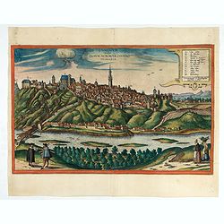
Brunn Vulgo Brinn Marchionatus Moraviae Civitas insignis.
Fine view of Brno seen from the southeast. TRANSLATION OF CAPTION: Brunn, in the vernacular Brno, eminent city in the Margravate of Moravia.COMMENTARY BY BRAUN: "Brn...
- $500 / ≈ €434
Date: Cologne, 1618

Deliciae Batavicae.
It is a charming book illustrated with portraits of Willem of Orange and Prince Maurits and eight engraved armorial plates. Followed by 30 engraved views or scenes of ...
Date: Amsterdam, Johannes Janssonius, 1618
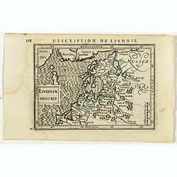
Livoniae Descrip.
A rare miniature map of the Baltic States Estonia, Latvia & Lithuania. The present map is one of the earliest obtainable maps to focus this region. Title cartouche o...
- $200 / ≈ €174
Date: Amsterdam, 1618
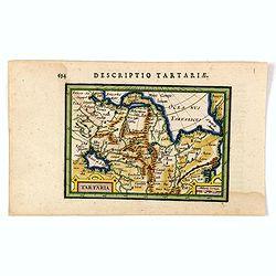
Tartaria.
An original early 17th century copper engraved miniature antique map of Tartary, China and part of America by Petrus Bertius.The title is displayed in a strap work cartou...
- $150 / ≈ €130
Date: Amsterdam, J.Hondius, 1618
![[Title page] Theatre Geographique du Royaume de France. . . .](/uploads/cache/48050-250x250.jpg)
[Title page] Theatre Geographique du Royaume de France. . . .
Title page by Nicolas de Clerc of ' Theatre Geographique du Royaume de France ". Joined page of " Table de toutes les cartes des provinces contenues", with...
Date: Paris, 1619
![[Lot of 6 Maps of Germany] PALATINATUS BAVARIAE.](/uploads/cache/IMG_2319-250x250.jpg)
[Lot of 6 Maps of Germany] PALATINATUS BAVARIAE.
[Lot of 6 Maps of Germany]- Palatinatus Bavariae. (H.Hondius & G.Mercator) circa. 1619 (490x370 mm)- La Basse Partie Du Cercle Du Haut Rhein divisé en tous ses ...
- $750 / ≈ €651
Date: Amsterdam, 1619
![[Lot of 17 maps] L' ISLE DE FRANCE Pariensis agri descriptio. Francois de la Hoeye fecit, Jean le Clerc excud.](/uploads/cache/19592-250x250.jpg)
[Lot of 17 maps] L' ISLE DE FRANCE Pariensis agri descriptio. Francois de la Hoeye fecit, Jean le Clerc excud.
The map of Ile de France which Jean Leclerc added in his re-issue of Maurice Bouguereau's atlas 'Theatre Francois' , as ' La Theatre geographique de France' in 1619. An u...
- $1000 / ≈ €868
Date: Paris, 1619
L'Isle de France / Parisiensis agri descrip.
Adorned with a title cartouche and a framing border. Leclerc's "Theatre geographique de France" is an extension of Bouguereau's "Theatre". A refugee w...
Date: Paris, ca. 1619
Caarte vande nieuwe Passagie bezuijden de Strate Magellan. . . / Description de nouveau passage vers le zud du destroit de Maggellan. . .
Map showing the new route around the bottom of South America discovered by Schouten and Le Maire: through the Le Maire Strait, around the Barnevelt Islands, and past Cape...
- $600 / ≈ €521
Date: Frankfurt am Main, 1619
Montana Ivdeae. . .
Text page with copper engraved illustration of Mount Judea taken from Itinerarium Hierosolymitanum et Syriacum, in quo variarum Gentium Mores et Institua insularum, regio...
- $80 / ≈ €69
Date: Antwerp, Verdussen, 1619
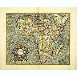
Africa ex magna orbis terre descriptione Gerardi Mercator. . .
A classic map of Africa. The map first appeared in Gerard Mercator’s Atlas sive Cosmographicae..., published posthumously in 1595. As stated in the title, this map is b...
Date: Duisburg and then Amsterdam, (1595) 1609 or 1619
Turcici Imperii descriptio.
Finely and early map of the Turkish Empire giving good detail in the Arabian Peninsula. From Isolario, engraved by Girolamo Porro.Read more about Mapping of Arabia and o...
Date: Padua 1620
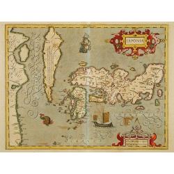
Japonia.
Jodocus Hondius' fine map early 17th-century map of the islands of Japan, was first issued as one of the new maps in the expended Mercator Hondius Atlas of 1606.The map i...
Date: Amsterdam, 1606-1620
Provinciae, Regionis galliae, vera exactissimaq. Descriptio
This is a highly detailed and well engraved map of Provence in southern France. Engraved by H.Picart and published by Jean le Clerc.Jean le Clerc (1560-1621) was an engra...
- $500 / ≈ €434
Date: Paris, ca. 1620
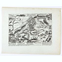
Belegerung der Vestung Gullich angefangen den 28. Julij, hat sich gegeben den 2. Sept. 1610.
Bird's eye-view of the siege of Jülich of 1610 which took place from 28 July to 2 September 1610, during the opening stages of the War of the Jülich Succession. After a...
- $150 / ≈ €130
Date: Cologne, 1620
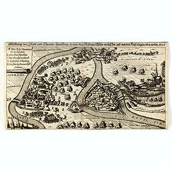
Abbildung der Stadt und Thumbs Havelberg, so von den Dennmarckischen verlassen und von den Keijs: eingenommen worden 1627”. Mindre fågelvy utan horisont med stridande trupper. . .
A separately published plan of the Danish town of Havelberg, with its siege of 1627. The copper engraved plan was also included in the work "Relationis Historicae S...
- $200 / ≈ €174
Date: Frankfurt am Main, ca. 1620
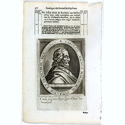
Carolus Magnus Romanorum Imperator Et Francorum Rex..
The engraving depicts a half length oval portrait of Charles the Great.Nicolaes de Clerck (de Klerc) was active as engraver and publisher in Delft from 1599-1621.Included...
- $20 / ≈ €17
Date: Amsterdam, Cloppenburch, 1621
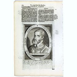
Carolus V D. G. Romanor Imperator Semper August.
The engraving depicts a half length oval portrait of Charles V (24 February 1500 – 21 September 1558) was ruler of both the Spanish Empire from 1516 and the Holy Roman ...
- $25 / ≈ €22
Date: Amsterdam, Cloppenburch, 1621
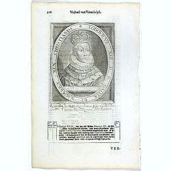
Lodovicus XIII. D. G. Galliae Et Navarrae Rex Christianiss.
The engraving depicts a half length oval portrait of Louis XIII of France.Nicolaes de Clerck (de Klerc) was active as engraver and publisher in Delft from 1599-1621.Inclu...
- $25 / ≈ €22
Date: Amsterdam, Cloppenburch, 1621