Browse Listings
Malta.
A miniature map of the lovely Mediterranean island of Malta, published by Petrus Bertius in Amsterdam, at the beginning of the seventeenth century. An attractive small ma...
- $200 / ≈ €174
Date: Amsterdam, 1606
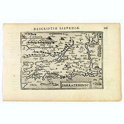
Sara et Zebenic.
A miniature map of Sara & Zebenic - in Croatia / Dalmatia in Eastern Europe, published by Petrus Bertius in Amsterdam, at the beginning of the seventeenth century. An...
- $100 / ≈ €87
Date: Amsterdam, 1606
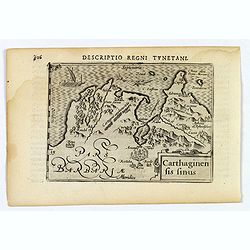
Carthaginensis Sinus.
A beautifully miniature map by Petrus Bertius of the ancient city of Carthage and the more modern town of Tunis, first published in 1598. There are numerous features tha...
- $100 / ≈ €87
Date: Amsterdam, 1606
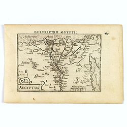
Aegyptus.
A fine miniature map of Egypt, published by Petrus Bertius in Amsterdam early in the seventeenth century. The lovely map and has a strap-work title, in the lower left cor...
- $100 / ≈ €87
Date: Amsterdam, 1606
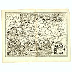
Natoliae Sive Asia Minor.
From the first edition. Map of Turkey, also depicting Cyprus.
Date: Amsterdam, 1606
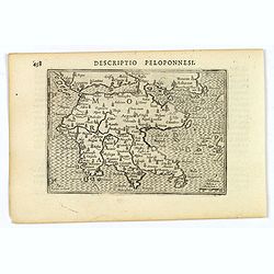
Descriptio Peloponnesi.
A fine miniature map of the southern Greek provence of Morea, the middle ages term for the Peloponnese peninsular, published by Petrus Bertius in Amsterdam early in the s...
- $100 / ≈ €87
Date: Amsterdam, 1606
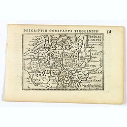
Tirolis Comita.
A lovely miniature map of the Tyrol region in the Alps, published by Petrus Bertius, in Amsterdam at the beginning of the seventeenth century. The map has a plain strap-w...
- $80 / ≈ €69
Date: Amsterdam, 1606
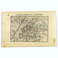
Europa.
A lovely miniature map of the continent of Europe, published by Petrus Bertius, in Amsterdam at the beginning of the seventeenth century.Engraved by J. Hondius, it has a ...
Date: Amsterdam, 1606
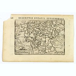
Lutzenburg.
A lovely miniature map of the small, landlocked European country of Luxembourg, published by Petrus Bertius, in Amsterdam at the beginning of the seventeenth century. The...
Date: Amsterdam, 1606
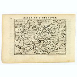
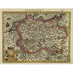
Helvetia.
A lovely miniature map of Switzerland, published by Petrus Bertius, in Amsterdam at the beginning of the seventeenth century.Full of facinating topographical detail, and ...
Date: Amsterdam, 1606
![Descriptio Gadium [France].](/uploads/cache/43237-250x250.jpg)
Descriptio Gadium [France].
An attractive miniature map of France, published by Petrus Bertius, in Amsterdam at the beginning of the seventeenth century. Title in bold capital letters above map, sti...
Date: Amsterdam, 1606
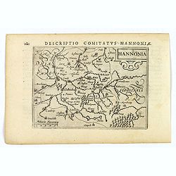
Hannonia.
An attractive miniature map of the Belgian, region of Hainaut, published by Petrus Bertius, in Amsterdam at the beginning of the seventeenth century. It features a small ...
Date: Amsterdam, 1606
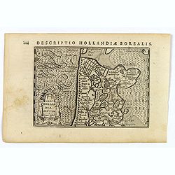
Hollandia Septentrionalis.
An attractive miniature map of the north Holland, northwards from Amsterdam to the Zijpe polder, published by Petrus Bertius, in Amsterdam at the beginning of the sevente...
Date: Amsterdam, 1606
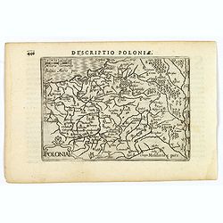
Polonia.
A miniature map of the Polish-Lithuanian Commonwealth, published by Petrus Bertius, in Amsterdam at the beginning of the seventeenth century. It features a small strap-wo...
Date: Amsterdam, 1606
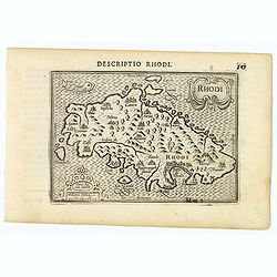
Rhodi.
A beautiful miniature map of the Greek island of Rhodes, published by Petrus Bertius in Amsterdam at the beginning of the seventeenth century.Engraved by Petrus Kaerius. ...
Date: Amsterdam, 1606
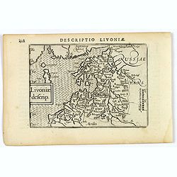
Livoniae descrip.
An attractive miniature map of the Baltic region of Livonia, as it was at the beginning of the seventeenth century, and published by Petrus Bertius in Amsterdam. The map ...
Date: Amsterdam, 1606
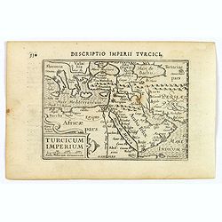
Turcicum Imperium.
A really attractive miniature map of The Turkish Empire, as it was at the beginning of the seventeenth century. Published by Petrus Bertius in Amsterdam. The map stretche...
Date: Amsterdam, 1606
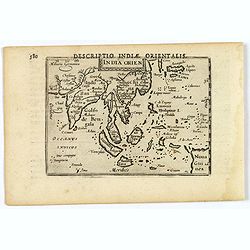
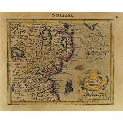
India Orientalis.
This lovely miniature map shows the East Indies, stretching from Persia to China and Japan, down to Java, and part of Papua new Guinea. Published by Petrus Bertius, in Am...
Date: Amsterdam, 1606
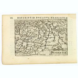
Brabantia.
A lovely miniature map of the Duchy of Brabant, published by Petrus Bertius, in Amsterdam at the beginning of the seventeenth century. There is a nice, small strap-work t...
Date: Amsterdam, 1606
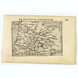
Gasconia.
A lovely miniature map of Gascony, in the S.W. region of France, published by Petrus Bertius, in Amsterdam at the beginning of the seventeenth century. There is a small s...
Date: Amsterdam, 1606
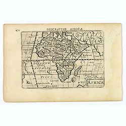
Africa.
A lovely miniature map of the continent of Africa, published by Petrus Bertius, in Amsterdam at the beginning of the seventeenth century. There is a small strap-work titl...
Date: Amsterdam, 1606
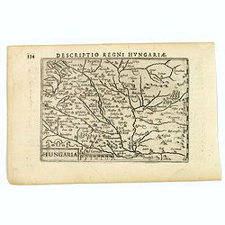
Hungaria.
A lovely miniature map of Hungary, published by Petrus Bertius, in Amsterdam at the beginning of the seventeenth century. There is a decorative strap-work title, and the ...
Date: Amsterdam, 1606
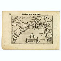
Bengala.
A lovely miniature map of a section of the Bay of Begal, published by Petrus Bertius, in Amsterdam at the beginning of the seventeenth century. There is a decorative stra...
Date: Amsterdam, 1606

Ormus (Straits of Hormus)
A lovely miniature map of the Kingdom of Ormus, published by Petrus Bertius, and published in Amsterdam at the beginning of the seventeenth century. With an attractive st...
Date: Amsterdam, 1606

Arabia
A lovely miniature map the Arabian Peninsular, published by Petrus Bertius, and published in Amsterdam at the beginning of the seventeenth century. With an attractive s...
Date: Amsterdam, 1606
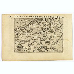
Flandria.
A lovely set of miniature map of Flanders. With an attractive strap-work title, and with detailed topography and information. Bertius (1565-1629) was a Flemish cartograph...
Date: Amsterdam, 1606
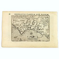
Valentia.
A fine miniature map of the Spanish province of Valencia, published by Petrus Bertius in Amsterdam early in the seventeenth century. The map features a nice strap-work ti...
Date: Amsterdam, 1606
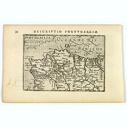
Portugallia.
A nice miniature map of Portugal, published by Petrus Bertius, in Amsterdam, at the beginning of the seventeenth century. North is orientated to the right. Strap-work tit...
Date: Amsterdam, 1606
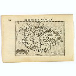
Corsica.
A fine miniature map of the French island of Corsica, published by Petrus Bertius in Amsterdam early in the seventeenth century. The map features a strap-work title carto...
- $300 / ≈ €260
Date: Amsterdam, 1606
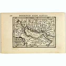
Descriptio Regni Ormuzii / Ormus.
A lovely miniature map of the Kingdom of Ormus, published by Petrus Bertius, and published in Amsterdam at the beginning of the seventeenth century. With an attractive st...
- $450 / ≈ €390
Date: Amsterdam, 1606
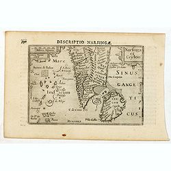
Descriptio Narsingae / Narsinga et Ceylon.
A rare miniature map of the southern part of India with Sri Lanka. The title cartouche on the upper right corner.First published in 1598 in his Caert-Thresoor, the plates...
- $350 / ≈ €304
Date: Amsterdam, Cornelis Claes, 1606

Descriptio Arabie / Arabia.
A rare miniature map of the Arabian Peninsular. The title cartouche on the lower right corner.First published in 1598 in his Caert-Thresoor, the plates were executed by t...
Date: Amsterdam, Cornelis Claes, 1606
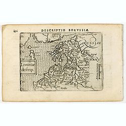
Descriptio Borussiae / Livoniae descrip.
A rare miniature map of Livonia. Title cartouche on the lower left corner.First published in 1598 in his Caert-Thresoor, the plates were executed by the most famous engra...
- $350 / ≈ €304
Date: Amsterdam, Cornelis Claes, 1606
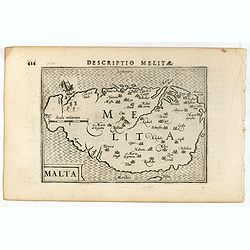
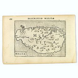
Descriptio Melitae / Malta.
A rare miniature map of Malta. Title cartouche on the lower left corner.First published in 1598 in his Caert-Thresoor, the plates were executed by the most famous engrave...
- $300 / ≈ €260
Date: Amsterdam, Cornelis Claes, 1606
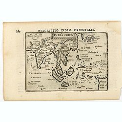
India Orien.
A miniature map showing India and the islands of Borneo, New Guinea, Sumatra, Java, etc.Korea as an enlonged peninsular and one town marked.First published in 1598 in his...
- $400 / ≈ €347
Date: Amsterdam, Cornelis Claes, 1606
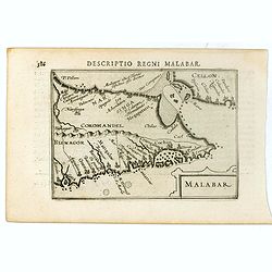
Malabar.
Very fine early miniature map of southern part of India and a part of Ceylon island. Title cartouche on the lower right corner.First published in 1598 in his Caert-Threso...
- $200 / ≈ €174
Date: Amsterdam, Cornelis Claes, 1606

Iava Maior.
Very fine miniature map of Java, engraved by Benjamin Wright (1575-1613). This early map contains detailed geography and nomenclature around the northern coastline of the...
Date: Amsterdam, Cornelis Claes, 1606
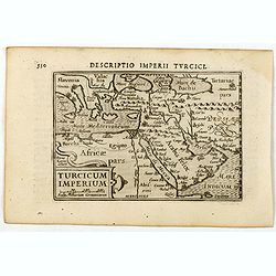
Descriptio Imperii Turcici / Turcicum Imperium.
A rare miniature map of the Arabian Peninsular. Title cartouche on the lower right corner.First published in 1598 in his Caert-Thresoor, the plates were executed by the m...
- $300 / ≈ €260
Date: Amsterdam, Cornelis Claes, 1606
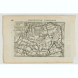
Descriptio Tartariae / Tartaria.
A rare miniature map of Tartary and China, showing the Great Wall. Title cartouche on the upper left corner.First published in 1598 in his Caert-Thresoor, the plates were...
- $300 / ≈ €260
Date: Amsterdam, Cornelis Claes, 1606
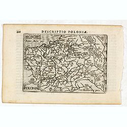
Descriptio Poloniae / Polonia.
A rare miniature map of Poland. Title cartouche on the lower left corner.First published in 1598 in his Caert-Thresoor, the plates were executed by the most famous engrav...
- $400 / ≈ €347
Date: Amsterdam, Cornelis Claes, 1606
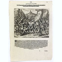
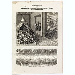
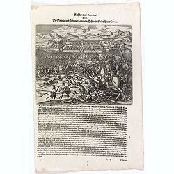
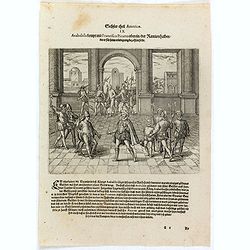
Die Schlacht zwischen Vaca de Castro, und Almagro dem jüngern.
Even before Pizarro’s death, a new royal governor, Vaca de Castro, was on his way to settle the turmoil in Peru. He refused to accept Almagro the younger, when he heard...
- $150 / ≈ €130
Date: Frankfurt, 1607
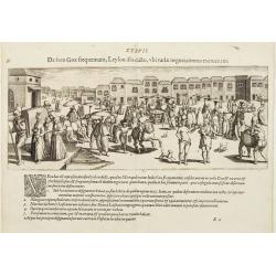
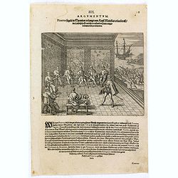
De foro Goae frequentato..
An attractive panorama view of the market square at Goa, with Indians and Portuguese traders, buying and selling various merchandise, with a row of colonial buildings in ...
Date: Frankfurt, 1607
Die Spanier treiben allerhand Unzucht mit den Indianischen Weibern die sie in dem läger unnd Wasserbädern ergriffen nach dem Atabaliba gefangen worden.
Spanish soldiers march past a pool where native American women are bathing. Some of the soldiers drag some of the women away. After the defeat of the Inca king, some of t...
- $150 / ≈ €130
Date: Frankfurt, 1607
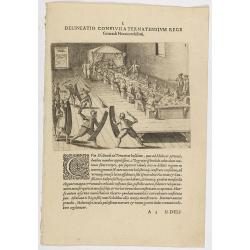
I. Delineatio convivii a Ternatensium rege Generali Neccio exhibiti.
This famous and desirable scene from Roelof Roelofsz's narrative of a voyage by J.C. van Neck to Ternate.Theodore de Bry, a German engraver and book dealer, began a compi...
- $100 / ≈ €87
Date: Frankfurt, Wolfgangi Richteri, 1607
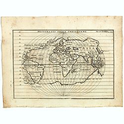
Designatio Orbis Christiani
Planispherical world map broadly based on Ortelius and similar to Hondius's Atlas Minor map of the same title. It shows most of the world, excluding the west coast of Nor...
- $450 / ≈ €390
Date: France, ca 1607
Wie der Indianer Brucken seyen von Seilen zusammen geflochten und vom Farth Guaynacapae.
Native Americans cross a net bridge over a river while one group cuts the end of it causing men to fall into the river and drown. Includes war clubs, spears, bows and arr...
- $100 / ≈ €87
Date: Frankfurt, 1607
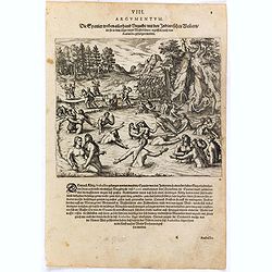
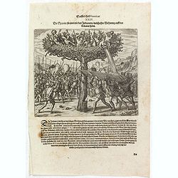
Die Spanier hawen die Bäume darauff die Indianer ihre wohnung haben mit Axten umb und stürtzen sie herunder.
Native Americans in trees drop stones on Spanish soldiers who attack from the ground. One man chops at a tree trunk while two others hold boards over his head to protect ...
- $100 / ≈ €87
Date: Frankfurt, 1607
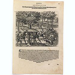
Die Spanier streiten mit den Indianern welche ihre Wohnung auff den Bäumen haben.
Native Americans in trees drop stones, shoot with arrows, and pour water on Spanish soldiers who attack from the ground. One man chops at a tree trunk while two others ho...
- $150 / ≈ €130
Date: Frankfurt, 1607
![Dess Ferdinandi und Petri de Contreras, gefangene Kriegssknecht werden zu Ranama [sic] durch den Statt Schultheissen mit einem Dolchen durchstochen.](/uploads/cache/37003-250x250.jpg)
Dess Ferdinandi und Petri de Contreras, gefangene Kriegssknecht werden zu Ranama [sic] durch den Statt Schultheissen mit einem Dolchen durchstochen.
Men are stabbed inside prisons while chests are loaded onto a boat. Includes men hanging from a tree seen through a barred window, chains, shackles, pillory, and knife. T...
- $100 / ≈ €87
Date: Frankfurt, 1607
Die Spanier gehen gantz Tyraiñsch mit den Indianern umb welche nicht fort kommen mochten . . .
As Pedro de la Gasca advanced from the north with about 1,500 soldiers, the journey from Trujillo to Ayacucho up the Eastern Cordillera was a terrible experience for the ...
- $100 / ≈ €87
Date: Frankfurt, 1607
Der meinste theil in Peru ubten nur ihren mutwillen under dem schein als ob sie Kay. May. gehorsam leisten.
A Spanish gentleman is stabbed in bed by a soldier. In the background other men are killed or murdered. Includes swords, spears, canopy, and knife. The self-appointed gov...
- $150 / ≈ €130
Date: Frankfurt, 1607
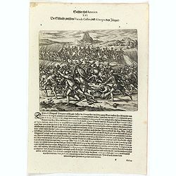
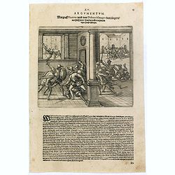
Blascus Nunnez Vela Königlicher Statthalter ersticht den Guillanum Xuarez Königlichen Proc. . .
Life under the new governor, Vaca de Castro, was no more stable than before and the king of Spain was eventually forced to send out yet another governor to replace him. H...
- $150 / ≈ €130
Date: Frankfurt, 1607
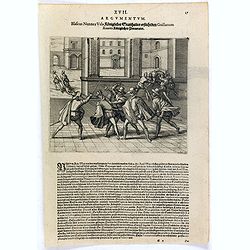
Margraff Pizarrus wird von Didoco Almagro dem jüngern mit hülff seiner Bundgenossen in . . .
Almagro’s son planned to take revenge on Pizarro for his father’s death. In 1541, with the help of Juan de Herrada and other Almagro supporters, they besieged Pizzaro...
- $100 / ≈ €87
Date: Frankfurt, 1607
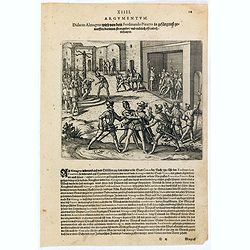
Didacus Almagrus wird von dem Ferdinando Pizarro in gefängnuss geworffen darinnen strangul. . .
Almagro returned to Cuzco, disillusioned and embittered from his long and fruitless journey south into Chile, where he had been searching for further wealth. This led to ...
- $100 / ≈ €87
Date: Frankfurt, 1607
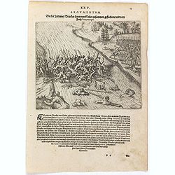
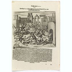
Die Spanier und Indianer halten eine Schlacht für der Stadt Cuzco.
Spanish soldiers, some on horseback, fight before a fortified town against native Americans. Includes guns or muskets, drums, swords, spears, fortifications, and scene of...
- $100 / ≈ €87
Date: Frankfurt, 1607
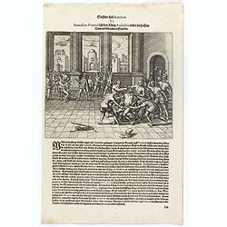
Die Stadt Cuzco so die reichste war in gantzen Königreich Peru wirdt von den Spaniern eingenommen.
Spanish soldiers fight in a fortified town against native Americans. Includes guns or muskets, swords, spears, fortifications, and scene of warfare.After Atahualpa was ki...
- $100 / ≈ €87
Date: Frankfurt, 1607
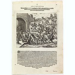
Franciscus Pizarrus lässt den König Atabaliba wider verheissene trew und glauben auff . . .
Atahualpa who is chained to his chair is garroted or executed in a room with Spanish soldiers and blacks [slaves]. Includes spears, gun or musket, headdress, pole and rop...
- $100 / ≈ €87
Date: Frankfurt, 1607
Als dem König Atabaliba zugesagt war dass er widerumb ledig werden solt schickte er die. . .
Spanish soldiers on horseback supervise native Americans who bring gold and silver vessels and statues to a fortified city. Includes vessels, animals such as a lobster, a...
- $100 / ≈ €87
Date: Frankfurt, 1607
Atabaliba kompt mit Francisco Pizarro ubereyn der Rantzion halben die er für sein erledigung bezahlen solte. . .
Atahualpa or Atabaliba talks to Francisco Pizarro in a room with Spanish soldiers. Includes spears, guns or muskets, and dwellings. Accompanying Pizarro was a monk called...
- $100 / ≈ €87
Date: Frankfurt, 1607
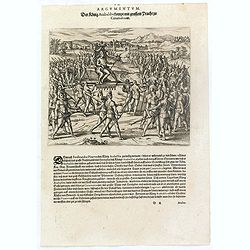
Der König Atabaliba kompt mit grossem Pracht zu Caxamalca an.
The Inca king, Atahualpa or Atabaliba, holding a scepter in the shape of a sun is carried on a litter by native American soldiers. In the background is a fortified city. ...
- $100 / ≈ €87
Date: Frankfurt, 1607
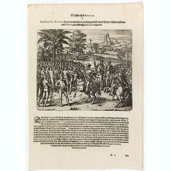
Ferdinandus de Soto Hauptmann uber das Kriegssvolck wardt sampt etlichen anderen von Pizarro, zu dem König Atabaliba abgesandt.
Hernando de Soto on horseback greets a native American carrying a scepter in the shape of a sun.They are surrounded by native American and Spanish soldiers. Includes war ...
- $100 / ≈ €87
Date: Frankfurt, 1607
Gonsaluus Pizarrus wird uberwunden gefangen und enthauptet.
Pizarro returned to Spain in 1528 and appealed to the king to grant him permission to conquer Peru. With him, he brought gold and silver, as evidence of their potential w...
- $100 / ≈ €87
Date: Frankfurt, 1607

Germania.
Second state of this rare "carte à figures"- map of Germany, The Netherlands, Poland and central Europe. Bordered on three sides with portraits and views. In t...
Date: Amsterdam, 1607

(Sea-chart of Catalunia, Languedoc, Provence, Cote d'Azur, Riviera, Corsica with Marseille, Cannes, Nice, Monaco.)
This very rare chart is important as the first printed sea chart of France's Mediterranean coast, also depicting Catalunya's northern coast, the Italian Cote d'Azur till ...
Date: Amsterdam, 1607

Udrone.
Map depicting present-day County Carlow in Leinster Province & Catherlaugh which is now Carlow. From the first French-text edition of Jodocus Hondius' Atlas Minor.Sho...
- $150 / ≈ €130
Date: Amsterdam, 1608
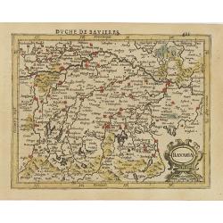
Bavaria.
Detailed map showing part of Bavaria. It covers the area between Ingolstadt and Salzburg.From the first French-text edition of Jodocus Hondius' Atlas Minor.Shortly after ...
- $50 / ≈ €43
Date: Amsterdam, 1608
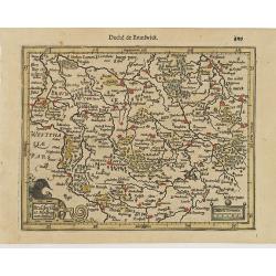
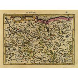
Brauswik et Meydburg com confinijs.
Detailed map showing the region around Brunswick and Magdeburg. With major cities of the area named.From the first French-text edition of Jodocus Hondius' Atlas Minor.Sho...
- $50 / ≈ €43
Date: Amsterdam, 1608
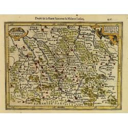
Saxoniae Superioris Lusatiae..
Detailed map of Saxony. With Prague at the bottom. From the first French-text edition of Jodocus Hondius' Atlas Minor.Shortly after the publication of the big folio-atlas...
- $50 / ≈ €43
Date: Amsterdam, 1608
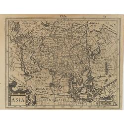
Asia.
Map of Asia with an oversized Korea and a curious shape for Japan, from the first French-text edition of Jodocus Hondius' Atlas Minor.Shortly after the publication of the...
Date: Amsterdam, 1608
Saxonia Inferior et Mekleburg.
Detailed map showing part of northern Germany. With major cities of the area named.From the first French-text edition of Jodocus Hondius' Atlas Minor.Shortly after the pu...
- $80 / ≈ €69
Date: Amsterdam, 1608
La Germanie.
Small map of Germany, including Austria and part of Poland. Strap work title cartouche in the lower left.From the first French-text edition of Jodocus Hondius' Atlas Mino...
- $75 / ≈ €65
Date: Amsterdam, 1608
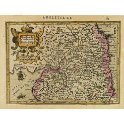
Northumbr. Cumberladia Dunelm. Episcop.
A map of the most northern part of England, from the first French-text edition of Jodocus Hondius' Atlas Minor.Shortly after the publication of the big folio-atlases the ...
- $100 / ≈ €87
Date: Amsterdam, 1608
Ultonia Oriental.
Map depicting part of Ulster, with the south-western tip of Scotland in the upper right. From the first French-text edition of Jodocus Hondius' Atlas Minor.Shortly after ...
- $75 / ≈ €65
Date: Amsterdam, 1608
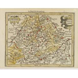
Wirtenberg.
Detailed map centered on Baden-Württemberg. With major cities of the area named.From the first French-text edition of Jodocus Hondius' Atlas Minor. Shortly after the p...
- $40 / ≈ €35
Date: Amsterdam, 1608
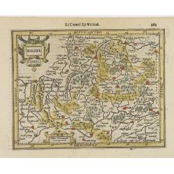
Waldek Comit.
Early map of the region surrounding Waldeck, northern Hessen. From the first French-text edition of Jodocus Hondius' Atlas Minor.Shortly after the publication of the big ...
- $45 / ≈ €39
Date: Amsterdam, 1608

Polus Arcticus cum vicinis regionibus.
Map of the North Pole regions from the 1608 second edition of Jodocus Hondius' Atlas Minor.A reduction of the 1606 Mercator-Hondius folio map (which is a later state of t...
Date: Amsterdam, 1608
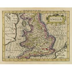
Anglia.
Map of England, from the first French-text edition of Jodocus Hondius'' Atlas Minor.Shortly after the publication of the big folio-atlases the need was apparently felt fo...
- $150 / ≈ €130
Date: Amsterdam, 1608
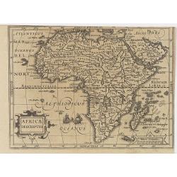
Africae Descriptio.
Map of Africa from the first French-text edition of Jodocus Hondius' Atlas Minor.Shortly after the publication of the big folio-atlases the need was apparently felt for a...
Date: Amsterdam, 1608
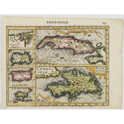
Cuba Insula. Hispaniola.
Decorative engraved map of Cuba above Hispaniola with smaller insets of Havana, Jamaica, Puerto Rico and Margarita.From the first French-text edition of Jodocus Hondius''...
- $300 / ≈ €260
Date: Amsterdam, 1608
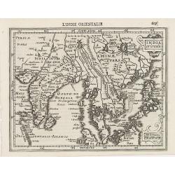
Indiae Orientalis.
This map covers an area including India, part of Malaysia, Borneo and China.From the first French-text edition of Jodocus Hondius' Atlas Minor.Shortly after the publicati...
Date: Amsterdam, 1608