Browse Listings

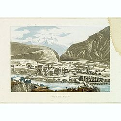
Vue de Gattweick et de l'embouchure du Rhin, dans la Mer du Nord.
Very decorative view of Katwijk. Signed lower right, Louis Bleuler au chateau de Laufen . Original design by Louis Bleuer. This gouache was the model for his aquatint in ...
Date: 1820
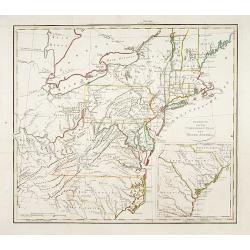
Gedeelte van den Vereenigden Staat van Noord Amerika.
A rare an detailed map of the eastern part of the United States of America. After Isaac Weld's map from his Travels through the States of North America 1799. Barbara Back...
- $650 / ≈ €552
Date: Netherlands c. 1820

Coiffure ornee de marabouts. . . (1875)
From Costume Parisien (1797-1839).Paris was the capital for fashion innovation and design. After the final defeat of Napoleon, English and French fashions merged to close...
Date: Paris, 1820
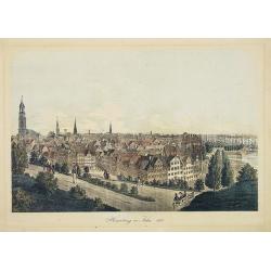
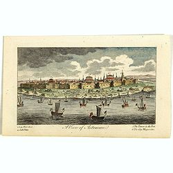
Hamburg im Jahre 1813
Decorative lithographed view of Hamburg. The print is issued in colors but finished by hand.
- $150 / ≈ €127
Date: Germany,1820

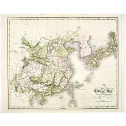
Chungguk-do
Chungguk-do [Map of China] taken from a Korean printed Ch’onha chido [Atlas of all under Heaven] which is a 19th century version of the traditional Korean atlas produce...
Date: Korea, ca. 1820

Manuscript plan of Havana harbour.
Manuscript chart with good nautical detail and soundings of Havana harbour.
Date: Spain c.1820
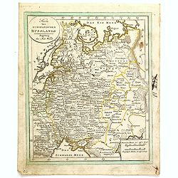
![[No tittle] Partie de la Prusse.](/uploads/cache/30632-250x250.jpg)
[No tittle] Partie de la Prusse.
Detailed map of the south of Baltic Sea. With a paper printed label of the Paris map seller Jean Goujon who was active from 1793-1826. The label carries the address of Ru...
- $90 / ≈ €76
Date: Paris, c. 1820
Karte des Europaeischen Russland. . ..
Nice small map of Russia.
- $100 / ≈ €85
Date: Augsburg, 1820
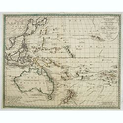
Australien (Südland) auch Polynesien oder Inselwelt..
SECOND EDITION of the Johann Walch map of Australasia and the South Pacific. Australia lettered Neu Holland, the name given to it by Able Tasman that was still in use un...
Date: Augsburg, 1802-1820
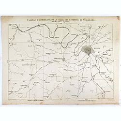
Tableau d'assemblage de la carte des environs de Versailles dite chasses impériales.
Key sheet to the rare 12 sheet map "Carte topographique des environs de Versailles dite des Chasses Impériales, levée et dressée de 1764 à 1773 par les ingénieu...
Date: Paris, ca. 1820
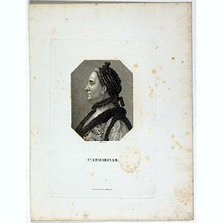
Catharina II.
Portrait of Catharina II (1729-1796) or Catherine the Great, Empress of Russia. During the reign of the flamboyant and powerful Empress Catherine II of Russia, whose long...
- $60 / ≈ €51
Date: Germany, ca. 1820
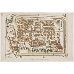
La factorerie chinoise a nagasaki, dans la rue Teng-chan (fondée en 1688).
The Chinese traders at Nagasaki were confined to a walled compound which was located in the same vicinity as Dejima island; and the activities of the Chinese, though less...
- $500 / ≈ €425
Date: Paris, A. Nepveu, 1820
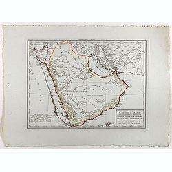
Carte de l'Arabie d'après les différents morceaux qu'a donnés M. Niebuh...
Detailed map of the Arabian peninsular, after Niebuhr, with scales in lower left corner. Engraved by Pierre-Paul Dubuisson.More about Mapping of Arabia [+]
Date: Paris, ca. 1820

Carte générale de l' Amérique divisée en ses principaux états . . .
Map of North and South America. By C. F. Delamarche, successor of Robert de Vaugondy, Geographer. Descriptive text to the left.
Date: Paris, 1820

Carte de l'Arabie d'après les différents morceaux qu'a donnés M. Niebuh...
Detailed map of the Arabian Peninsula, after Niebuhr, with scales in the lower left corner. Engraved by Pierre-Paul Dubuisson.More about Mapping of Arabia [+]
Date: Paris, ca. 1820
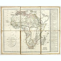
Carte générale de L'Afrique divisée en ses principaux états par Fx Delamarche. . .
Uncommon map of Africa prepared by Felix Delamarche, after R.de Vaugondy. The "Zahara ou Grand désert" and Congo and Zambia "Contrée tout-a-fait Inconnue...
- $300 / ≈ €255
Date: Paris, 1820
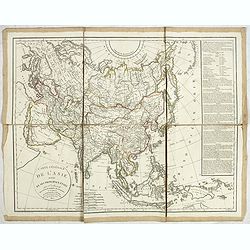
Carte générale de L'asie . . .
Uncommon map of Asia prepared by Felix Delamarche, after R.de Vaugondy. In the right hand a lengthy description of geographical details of the different European countrie...
Date: Paris, 1820

Le Baron d'Amstett. Ministre de Russie.
Full portrait of Johann Protasius von Anstett (* 1766 in Straßburg; † 14. Mai 1835) after Lieder and lithographed by G.Engelmann. Anstett, son of a lawyer in Strasbour...
- $40 / ≈ €34
Date: Paris, ca. 1820
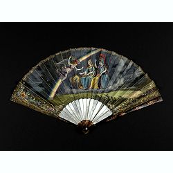
Very fine folding fan with painting of Minerva, Juno and 2 peacocks.
Small folding fan made of double skin sheet, mounted in English style, painted with gouache and depicting Minerva and Juno sitting near each other and receiving the visit...
Date: ca. 1820
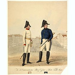
K.K. Österreichischer Platz Offizier und Stabs-Feld Arzt.
Rare hand-colored lithograph published in the work on the Austrian Military "Bildliche Darstellung der K. K. Österreichischen Armee". Figurs a military medical...
- $70 / ≈ €59
Date: Vienna, c. 1820
A View of Astracan. (Astrakhan)
A striking and highly detailed copper engraved panoramic view of Astrakhan, Russia, with its buildings, churches and town wall. The River Volga in the foreground. Several...
- $50 / ≈ €42
Date: London, 1820
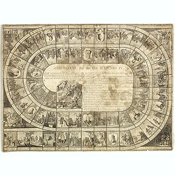
Jeu Royal de la vie d'Henri IV.
Large sheet with an animated Goose-game of 63 numbered squares, spiral, counterclockwise, centripetal focused on the French king Henri IV.André Basset offers the life of...
Date: Paris, ca. 1816-1820
Charte von China nach Murdochischer Projection entworfen. ... Berichtiget, und gezeichnet von H.F.A. Stieler. . .
Uncommon map of China prepared by H.F.A.Stieler, with parts of Taiwan, Tibet, Mongolia and the Korean peninsula, with a great many place names, a key to (and brief explan...
Date: Augsburg, 1820
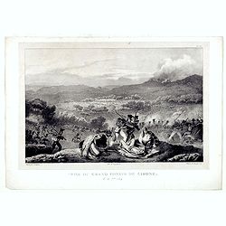
Prise du Grand Convoi de Girone le 26 Fbie 1809.
Fine lithography showing a battle scene during Third Siege of Girona by Godefroy Engelmann" after a drawing by C. Langlois. Godefroy Engelmann was born in 1788 in M�...
Date: Paris, ca. 1820
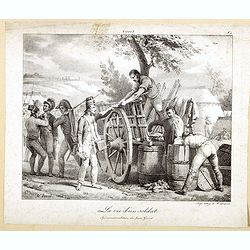
La vie d'un soldat, équipement militaire du jeune Grivet.
Early lithography after a painting of Joseph Claude Vernet (1714-1789).Lithographed by François-Séraphin Delpech (1778 – 25 April 1825) who was a French artist and li...
Date: Paris, ca. 1820
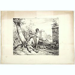
1795 (Lithography showing a group of wounded Napoleonic solders)
Group of wounded Napoleonic solders being treated by an army med, after Carle Vernet (1758 - 1836) and lithographed by François-Sérafin Delpech (1778-1825)
Date: Paris, 1820
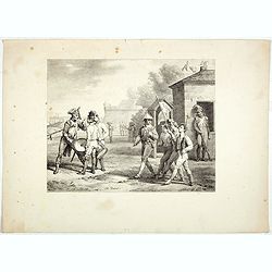
Napoleonic solder's.
Group of Napoleonic solder's with standard and drums after Carle Vernet (1758 - 1836) and lithographed by François-Sérafin Delpech (1778-1825)
Date: Paris, 1820
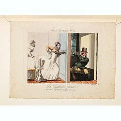
La Curiosite punie, aventure hydrauli-comique et vraie.
A charming and delightful hand colored etching in the grand French style of the early nineteenth century from "Musee Grotesque No. 20" : La Curiosite punie, ave...
Date: Paris, ca. 1816-1820
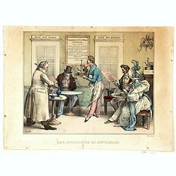
Les Jouissance du Juste Milieu.
[The Joys of the Happy Medium.] A waiter is about to serve a customer with a clyster pump and water jug. It looks as though the man has a 'menu' in one hand. On another t...
Date: Paris, ca 1820

Musee Grotesque No. 56
A charming and delightful hand colored etchings in the grand French style of the early nineteenth century. With title Maudits Bonbons ! (Damn Candies!) An infant is seen ...
- $100 / ≈ €85
Date: Paris ca 1816-1820
Karte der Hauptstraßen von der niederen Donau bis Constantinopel … / Spezialkarte des Meerbusens von Burgas . ..
Uncommon map of the routes of the eastern part of the Balkan Peninsula. prepared by C. Zirbeck The map has two insets "Meerbusen von Burgas oder Mesambri" (Bay ...
- $550 / ≈ €467
Date: 1820
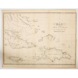
MAP OF THE Route of Columbus on arriving among the Bahama Islands.
An impressive detailed chart of the Bahama Bank, plus surrounding smaller islands, plus most of Cuba, Jamaica, Saint Domingo (Dominican Rep & Hayti). The map has grid...
Date: New York, ca.1820
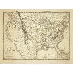
Carte Generale des Etats-Unis De L'Amerique Septentionale . . .
One of the earliest obtainable maps to show the United States From Coast to Coast, published in Paris by A.H. Brue.The map is especially interesting west of the Mississip...
Date: Paris, 1820
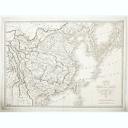
Carte de la Chine et du Japon. Dressée pour l'intelligence de l'histoire général des voyages de Laharpe. . .
Engraved by Tardieu for L'Intelligence de l'histoire generale des Voyages de Laharpe .Rare and detailed map of China, Korea, Japan and Taiwan (I.Formose ou Pekan).
Date: Paris, 1821
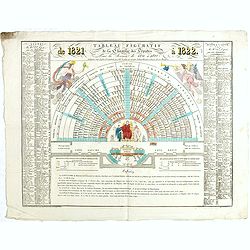
Tableau figuratif de la Chambre de Députés . . .
Figurative table of the Chamber of Deputies for the session of 1821. Showing as accurately as possible the place usually occupied by each of its members.
Date: Paris, ca. 1821
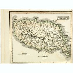
Grenada.
A delightfully detailed map the West Indian island Grenada by John Thomson. The map displays excellent detail concerning roads, rivers, towns, bays, harbours and other in...
- $50 / ≈ €42
Date: Edenburgh, 1821
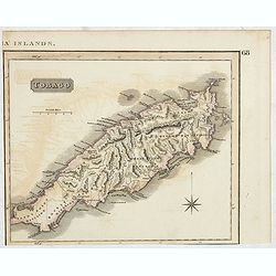
Tobago.
A delightfully detailed map of the West Indian island Tobago by John Thomson. The map displays excellent detail concerning roads, rivers, towns, bays, harbors, and other ...
- $50 / ≈ €42
Date: Edenburgh, 1821

London in Miniature With The Surrounding Villages. An Entire New Plan In which the Improvements both present and intended are actually reduced, by permission, from the surveys of the Several Proprietors. . .
Hand-coloured engraved map, dissected and mounted on linen, orange publishers label on one side, extending west to east from Kensington to East India and Greenwich Dock a...
Date: London, 1821
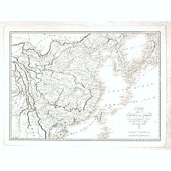
Carte de la Chine et du Japon..
Engraved by Tardieu for L'Intelligence de l'histoire generale des Voyages de Laharpe .Rare and detailed map of China, Korea, Japan and Taiwan (I.Formose ou Pekan).
- $100 / ≈ €85
Date: Paris, 1821
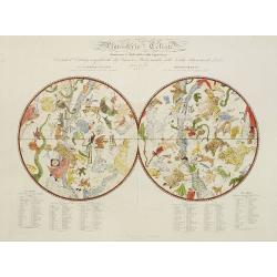
Planisferio Celeste contenente le stelle dalla 1 alla 5 grandezza. . .
Decorative large double hemisphere celestial chart, centred on the north and south poles with descriptive key to zodiac signs in German, French and Italian. Showing stars...
- $1500 / ≈ €1275
Date: Milan, c.1822
![[ First Separate Map of Michigan Territory ] Geographical, statistical, and historical map of Michigan territory.](/uploads/cache/25931-250x250.jpg)
[ First Separate Map of Michigan Territory ] Geographical, statistical, and historical map of Michigan territory.
The map illustrates Michigan Territory and the so-called "Indian Line" shortly after the Treaty of Chicago (1821), the third of three treaties with the Native A...
Date: Philadelphia, 1822
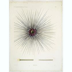
Oursins.
Decorative plate of a sea urchin, engraved by Boquet. Marie Jules César Lelorgne de Savigny (April 5, 1777 - October 5, 1851) was a French zoologist. In 1798 he traveled...
Date: Paris, 1822
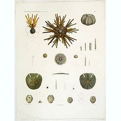
Oursins.
Showing sand dollars, sea urchin, etc. engraved by Macret. Marie Jules César Lelorgne de Savigny (April 5, 1777 - October 5, 1851) was a French zoologist. In 1798 he tra...
Date: Paris, 1822
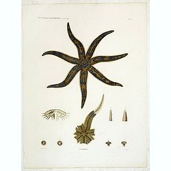
Astéries.
Decorative engraving of a star fish, engraved by Boquet. Marie Jules César Lelorgne de Savigny (April 5, 1777 - October 5, 1851) was a French zoologist. In 1798 he trave...
Date: Paris, 1822
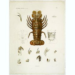
Hommards.
Decorative engraving of a lobster, by Tresca. Marie Jules César Lelorgne de Savigny (April 5, 1777 - October 5, 1851) was a French zoologist. In 1798 he traveled to Egyp...
Date: Paris, 1822
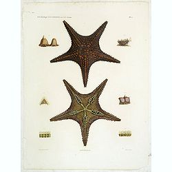
Astéries.
Decorative engraving of star fishes, by Macret and Leleu. Marie Jules César Lelorgne de Savigny (April 5, 1777 - October 5, 1851) was a French zoologist. In 1798 he trav...
Date: Paris, 1822
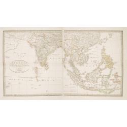
Charte von Ostindien Diesseits Und Jenseits Des Ganges / nach den neuesten astronomischen Beobachtungen auch andern sichern Hülfsmitteln neu entworfen. . .
Prepared by I.C.M.Reinecke giving good detail in India, Indonesia and the Philippines.
- $800 / ≈ €680
Date: Weimar, 1822
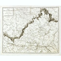
Carte de Moravie Dessinée et Gravée par Ambroise Tardieu.
Very detailed map including Vienna and the Czech Republic with Prague Olmutz.
- $40 / ≈ €34
Date: Paris, 1822
![[Title page] Pilote Français (environs de Brest) rédigé par M. Beaulieu-Beaupré . . .](/uploads/cache/41677-250x250.jpg)
[Title page] Pilote Français (environs de Brest) rédigé par M. Beaulieu-Beaupré . . .
Title page of "Pilote Français" with a view of "Goulet de Brest" (83x155mm.) Engraved by Schroeder and Besançon.
- $50 / ≈ €42
Date: Paris, Dépôt général de la Marine, 1822

Beautemps-Beaupré (Charles-François).
Portrait of Charles-François Beautemps-Beaupré, engraved by Boilly.Charles-François Beautemps-Beaupré (6 August 1766 in La Neuville-au-Pont – 16 March 1854 in Paris...
Date: Paris, 1822
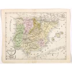
Carte de l'Espagne et du Portugal dréssée pour l'usage des Collèges 1822.
Uncommon lithographed map of Spain and Portugal taken from " Atlas Géographique. Géographie moderne actuelle. Pour l'usage des Collèges."
Date: Paris, 1822

Neptune des Côtes Occidentales de France.
Large maritime atlas illustrated with a handwritten title, a table and 47 single or double page charts. The charts show the western coasts of France as well as the Spanis...
- $12000 / ≈ €10199
Date: Paris, 1776-1822
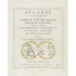
(Title page) Mappamondo sul Piano dell' Equatore. - Atlante Tascabile o sia Serie di Num. XXI Cartine Geografiche nelle quali si. . .
Engraved title page with in lower part a double polar projection (50x95mm.) from the rare atlas Atlante Tascabile o sia Serie di Num. XXI Cartine Geografiche nelle quali ...
- $100 / ≈ €85
Date: Rome, 1823
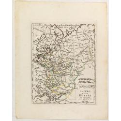
Impero della Russia in Europa a riserva delle ultime Conquiste sulla Polonia.
Charming map of the European part of Russia, including Finland, from the rare atlas Atlante Tascabile o sia Serie di Num. XXI Cartine Geografiche nelle quali si In Roma...
- $200 / ≈ €170
Date: Rome, 1823
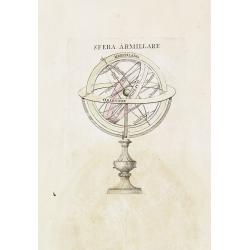
Sfera Armillare.
Charming armillary sphere, from the rare atlas Atlante Tascabile o sia Serie di Num. XXI Cartine Geografiche nelle quali si ... In Roma MDCCCIV Si vende presso lo Stampat...
- $80 / ≈ €68
Date: Rome, 1823
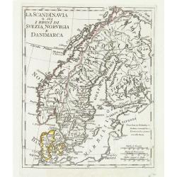
La Scandinavia o sia i regni di Svezia, Norvegia e Danimarca.
Charming and uncommon map of Scandinavia, including Norway, Sweden, Denmark, Finland and part of Russia, from the rare atlas Atlante Tascabile o sia Serie di Num. XXI Car...
Date: Rome, 1823
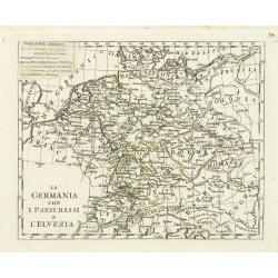
La germania con i Paesibassi e l'elvezia.
Charming map of Germany, The Netherlands, Switzerland and part of Poland from the rare atlas Atlante Tascabile o sia Serie di Num. XXI Cartine Geografiche nelle quali si ...
- $80 / ≈ €68
Date: Rome, 1823
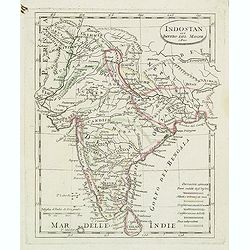
Indostan gia impero del mogol. . .
Charming map of India with Ceylon from the rare atlas Atlante Tascabile o sia Serie di Num. XXI Cartine Geografiche nelle quali si rappresenta in ristretto lo Stato Attua...
- $150 / ≈ €127
Date: Rome, 1823
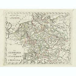
La germania con i paesi bassi e l'elvezia.
Charming map of Germany, Netherlands, Switzerland, Austria from the rare atlas Atlante Tascabile o sia Serie di Num. XXI Cartine Geografiche nelle quali si rappresenta in...
- $65 / ≈ €55
Date: Rome, 1823
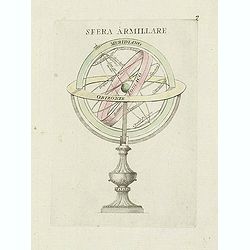
Sfera Armillare.
Charming engraving of a armillary globe from the rare atlas Atlante Tascabile o sia Serie di Num. XXI Cartine Geografiche nelle quali si rappresenta in ristretto lo Stato...
- $200 / ≈ €170
Date: Rome, 1823
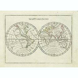
Mappamondo.
Charming world map in double hemisphere from the rare atlas Atlante Tascabile o sia Serie di Num. XXI Cartine Geografiche nelle quali si rappresenta in ristretto lo Stato...
- $250 / ≈ €212
Date: Rome, 1823
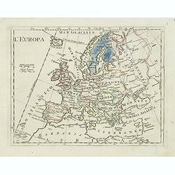
L'Europa.
Charming map of Europe from the rare atlas Atlante Tascabile o sia Serie di Num. XXI Cartine Geografiche nelle quali si rappresenta in ristretto lo Stato Attuale di tutte...
- $60 / ≈ €51
Date: Rome, 1823
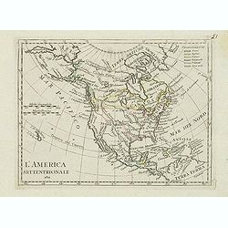
L'America septentrionale.
Charming and finely engraved map of North America from the rare atlas Atlante Tascabile o sia Serie di Num. XXI Cartine Geografiche nelle quali si rappresenta in ristrett...
- $275 / ≈ €234
Date: Rome, 1823

Het Huisje door Czaar Peter den Grooten in den Jare 1697 te Zaandam bewoond.
Engraved by Cornelis van Baarsel (Utrecht 1761 - Amsterdam 1826-08-17) after a design of T. Monsieur M.Z. who made his drawing "after nature".A first state, the...
Date: Zaandam, 1823

Map of Pensylvania and New Jersey by H.S. Tanner.
First edition of this rare and important map of Pennsylvania and New Jersey by H.S. Tanner and published in his "New American Atlas" from 1823. Includes roads, ...
Date: Philadelphia, Henry Tanner, 1823
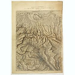
Carte de la Georgie et du Pays des Ossetes, Tcherkesses et Mitzdcheghi, Par Jules Klaproth (1823).
Detailed manuscript map of Georgia, based upon an 1823 map by Jules Klaproth. The map depicts the rugged terrain of Georgia and southern Russia in impressive detail from ...
- $4000 / ≈ €3400
Date: Paris, ca. 1823
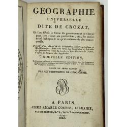
Geographie Universelle dite de Crozat.
A nice geographical dictionary with maps of the world and the continents and maps of European countries. Mappemonde, l'Europe, les provinces United des Pays Bas, Allem...
Date: Paris, 1823
Amérique septentrionale.
A fine map of North America published by the well-known Paris publisher of maps, globes and atlases C.F. Delamarche.
- $110 / ≈ €93
Date: Paris, 1824

Coeffure formée de velours . . .
From Costume Parisien (1797-1839).Paris was the capital for fashion innovation and design. After the final defeat of Napoleon, English and French fashions merged to close...
Date: Paris, 1824

Eastern passage to China. sheet 1.
James Horsburgh early chart of the coasts of Java, Bali, Lombok, with part of Sulawesi, and Borneo. Insets of "Sketch of Bally Strait", Sketch of Lombock Strait...
- $2500 / ≈ €2125
Date: London, 1824
![Das Fahrzeug auf welchem der Russische Gesandte zuert in Nangasaky ans Land fuhr. [Nagasaki]](/uploads/cache/24830-250x250.jpg)
Das Fahrzeug auf welchem der Russische Gesandte zuert in Nangasaky ans Land fuhr. [Nagasaki]
View of Nagasaki Harbour, with on foreground Japanese junks bringing the members of the first Russian expedition a shore. In the back ground the artificial island of Deji...
- $1750 / ≈ €1487
Date: St.Petersburg, 1824
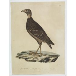
Mégapode la Pérouse. (33.)
Bird print taken from "Voyage autour du Monde... Zoologie" by Jean R.C. Quoy and Joseph P. Gaimard. The plate is engraved by Coutant after a design by P.Oudart.
Date: Paris, Langlois, 1824
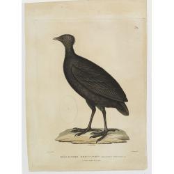
Mégapode Freycinet. (32.)
Bird print taken from "Voyage autour du Monde... Zoologie" by Jean R.C. Quoy and Joseph P. Gaimard. The plate is engraved by Coutant after a design by A.Prévos...
Date: Paris, Langlois, 1824
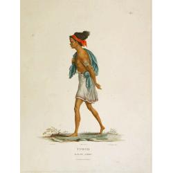
Timor - Malais libre.
A fine color plate from the rare travel book: Voyage de découvertes aux terres Australes . The Baudin voyage from 1800-1804 was the most successful French scientific exp...
- $100 / ≈ €85
Date: Paris, Langlois, 1824
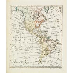
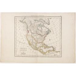
Amerika
Scarce miniature map of the Western Hemisphere.
- $200 / ≈ €170
Date: Augsburg, 1824
![[Untitled map of a part of Poland and Prussia].](/uploads/cache/25710-250x250.jpg)
[Untitled map of a part of Poland and Prussia].
Large folding map, being upper right part of a multi-sheet map, showing the northern part of Poland with good detail around Gdansk. Published by Jean Claude Dezauche (17...
- $400 / ≈ €340
Date: Paris, ca. 1816-1824
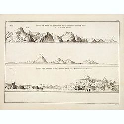
Ansicht der Küste von Kamtschatka vom Cap Poworotnoy Nordlich hinauf - Ansicht der Einfahrt in die Awatscha Bay, in einer entfernung von 4 meilen.
An original view in imperial folio size, originating from the original first edition (Russian & German) of Krusenstern's atlas to his voyage around the world: Atlas k...
- $1000 / ≈ €850
Date: St.Petersburg, 1824
China and Japan drawn and engraved for Dr. Playfairs Atlas.
Detailed map of China, Korea, Japan and Taiwan engraved by H. Cooper and published by Alexander Macredie. Originally engraved for James Playfair's " A New General At...
- $700 / ≈ €595
Date: Edinburgh, 1824
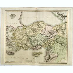
Modern Asia Minor. Drawn & Engraved for Dr. Playfair's Geography.
Detailed map of Black Sea, Cyprus and Turkey engraved by Samuel John Neele (1758-1824) and published by Alexander Macredie. Originally engraved for James Playfair's "...
- $175 / ≈ €149
Date: London / Edinburgh, 1824