Browse Listings
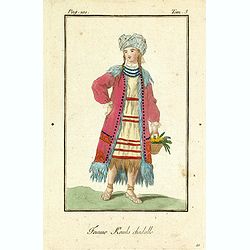
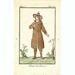
Femme Kamls chadalle.
Originally hand-colored mezzotint of native woman from Kams, Siberia, Russland engraved by Félix Mixelle and Lachaussée Jeune after Jacques Grasset de Saint-Sauveur.As ...
- $50 / ≈ €42
Date: Paris,1801-1806
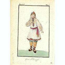
Femme Tschermifse.
Originally hand-colored mezzotint from 'Costumes civils actuels de tous les peuples connus'. Originally hand-colored mezzotint of Native Americans engraved by Félix Mixe...
- $50 / ≈ €42
Date: Paris,1801-1806
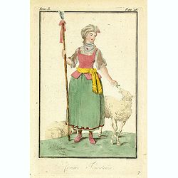
Femme Touralinze.
Originally hand-colored mezzotint from 'Costumes civils actuels de tous les peuples connus'. Originally hand-colored mezzotint of Native Americans engraved by Félix Mixe...
- $50 / ≈ €42
Date: Paris,1801-1806
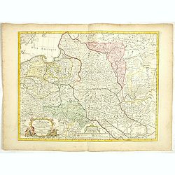
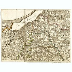
La Pologne Dressée sur ce qu'en ont donné Starovolsk, Beauplan, Hartnoch. . .
This is a late edition of the De L'Isle copper plate with a date of 1806. The copper plate was used many times and has several erased addresses. This one with address &qu...
- $750 / ≈ €637
Date: Paris, 1806
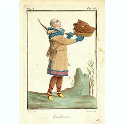
Femme Kourilienne.
Originally hand-colored mezzotint of a native Kourilles lady engraved by Félix Mixelle and Lachaussée Jeune after Jacques Grasset de Saint-Sauveur. From 'Costumes civil...
- $25 / ≈ €21
Date: Paris,1801-1806
Karakasse.
Originally hand-colored mezzotint of a native Tartary man holding a bear's head engraved by Félix Mixelle and Lachaussée Jeune after Jacques Grasset de Saint-Sauveur. F...
- $25 / ≈ €21
Date: Paris,1801-1806

Femme Kirguisses.
Originally hand-colored mezzotint of Native Tartary lady engraved by Félix Mixelle and Lachaussée Jeune after Jacques Grasset de Saint-Sauveur. From 'Costumes civils ac...
- $25 / ≈ €21
Date: Paris,1801-1806
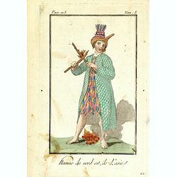
Homme du nord est de l'Asie.
Originally hand-colored mezzotint of a native from North Eastern Russia engraved by Félix Mixelle and Lachaussée Jeune after Jacques Grasset de Saint-Sauveur. From 'Cos...
- $50 / ≈ €42
Date: Paris,1801-1806
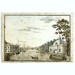
(Die Fontanka beim kaiserlichen Garten in Petersbourg.)
Fontanka River at the Summer Garden in Saint Petersburg. Part of a set of 14 loose and individually mounted plates of views of St. Petersburg and Moscow, plus one plate o...
- $100 / ≈ €85
Date: St. Peterdburg, 1806
![Fille Wotÿake [together with] Femme Wotÿake.](/uploads/cache/36934-250x250.jpg)
Fille Wotÿake [together with] Femme Wotÿake.
Set of two originally hand-colored mezzotints of Native Russians engraved by Félix Mixelle and Lachaussée Jeune after Jacques Grasset de Saint-Sauveur.As an etcher, dra...
- $35 / ≈ €30
Date: Paris,1801-1806
![[Title page] Atlas Universel. . .](/uploads/cache/48053-250x250.jpg)
[Title page] Atlas Universel. . .
Beautiful title-frontispiece from the famous universal atlas initiated by geographers Gilles Robert and his son Didier Robert de Vaugondy, revised, corrected and enhanced...
Date: Paris, 1806
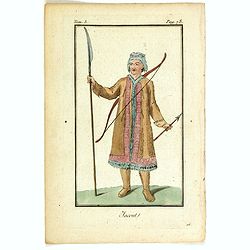
Jacout.
Originally hand-colored mezzotint from 'Costumes civils actuels de tous les peuples connus'. Originally hand-colored mezzotint of Native Americans engraved by Félix Mix...
- $50 / ≈ €42
Date: Paris,1801-1806
![[Beatles]](/uploads/cache/49038-250x250.jpg)
[Beatles]
Plate III from Carl Gustav Jablonsky and J.F.W. Herbst: "Natursystem aller bekannten in- und ausländischen Insecten", engraved by Bodenehr. Carl Gustav Jablons...
Date: Berlin, J. Pauli, 1785-1806

Asia.
Uncommon map of Asia. Engraved by Marco di Pietro.The map is of interest for the use of G. di Corea, for the sea between Korea and Japan.Published by Carlo Antonio Barbie...
Date: Milan, 1807
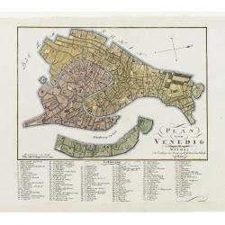
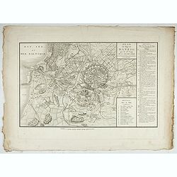
Plan von Venedig.
An uncommon and finely rendered town-plan of Venice. The work is highly detailed and provides a 133-point legend identifying the town's key sites and places of import. L...
Date: Weimar, 1807
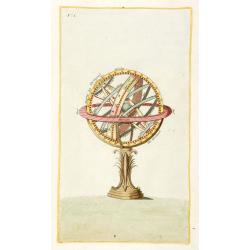
Sphere (No title)
Rare Italian print of a sphere. Paper size 350x225mm. From his "Atlante della geografia antica e moderna".
- $120 / ≈ €102
Date: Milan, 1807
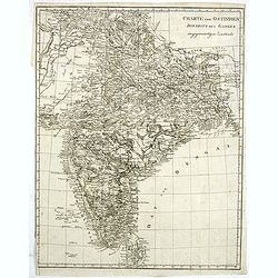
Charte von Ostindien disseits des Ganges im gegenwärtigen Zustande.
A uncommon issue of this detailed map of India, including Ceylon.
Date: Weimar, 1807

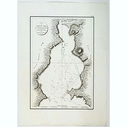
Plan de la Baie de L'Adventure. . .
A French maritime chart of Adventure Bay in S.E. Tasmania. Adventure Bay is the name of both a township and a geographical feature on the eastern side of Bruny Island. Th...
Date: Paris, ca 1807

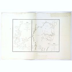
Plan du Port du Sud de la Baie de la Recherche / Croquis de la Baie des Moules. . .
A French maritime chart of the Port du Sud in Research Bay and the mouth of the Bay of Mussels, both in southern Tasmania. This is the edition of the extremely rare atlas...
Date: Paris, ca 1807
Plan du Port du Nord de la Baie de la Recherche.
A French maritime chart of the plan of the northern portion of Recherche Bay on the S.E. tip of Tasmania. The chart has some physical detail, outlining trees and hills, b...
Date: Paris, ca 1807
Plan du Port Jackson / Plan du Comte de Cumberland.
Two maps on one sheet showing the earliest scientific surveys of Port Jackson and the area surrounding Sydney Harbour, undertaken by the French in 1802. This is the editi...
Date: Paris, 1807
Carte de la Baie des Chiens-Marins (Shark's Bay de Dampier). . .
A strikingly detailed chart of a portion of the coastline of Western Australia, titled 'Carte de la Baie des Chiens-Marins, which William Dampier also explored. The chart...
Date: Paris, 1807

Plan de L'Isle de Paque / Plan de la Baie de Cook.
Two engraved maps and four coastal profiles of Easter Island in the Pacific. First published in the Atlas du Voyage de la Perouse. This is the edition of the extremely ra...
Date: Paris, 1797-1807

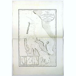
Carte de L'Archipel de La Recherche a la partie Occidentale de la Terre de Nuyts. . .
A large and detailed chart of the southern West Australian coast centered on the region of Esperance and the surrounding islands.Terre de Nuyts is the name that was forme...
Date: Paris 1807
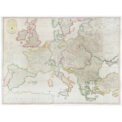
(Post Roads of Europe) Neueste Allgemeine Postkarte von Europa in welcher samtliche Postrouten aller europaischen Staaten nach den zuverlässigsten Postbüchern. . .
The largest postal map of Europe, published in Vienna in the midst of the Napoleonic Wars. This postal map of Europe first appeared in 1798 and is considered one of the e...
Date: Vienna, 1807
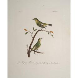
Le Figuier Tcheric.
Very decorative plate from Histoire naturelle des oiseaux d'Afrique , published by Delachaussée. Levaillant's interest in natural history led him to explore Africa as th...
- $180 / ≈ €153
Date: Paris 1796-1808

Carte Réduite Du Golphe Du Mexique Et Des Isles De L' Amérique..
A well engraved and highly detailed chart prepared by Bellin of the Gulf of Mexico and the Caribbean. In addition to a magnificent title cartouche and a color key to the ...
Date: Paris dated year 17, or 1808
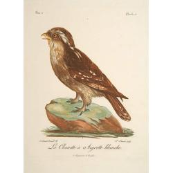
La Chouette a Aigrette Blanche.
Very decorative plate from Histoire naturelle des oiseaux d'Afrique , published by Delachaussée. Levaillant's interest in natural history led him to explore Africa as th...
- $120 / ≈ €102
Date: Paris, 1796-1808

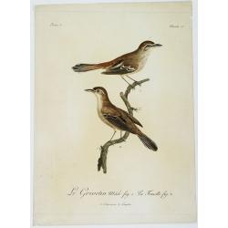
Le Capolier. Fig. 1 Le Mâle. La Queue Gazée Fif. 2. Planche 130.
Very decorative plate from Histoire naturelle des oiseaux d'Afrique , published by Delachaussée. Levaillant's interest in natural history led him to explore Africa as th...
Date: Paris, 1796-1808
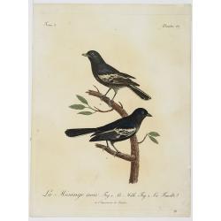
La Mésange noir. Fig.1 Le Mâle. Fig.2. La Femelle. Planche 137.
Very decorative plate from Histoire naturelle des oiseaux d'Afrique , published by Delachaussée. Levaillant's interest in natural history led him to explore Africa as th...
Date: Paris, 1796-1808
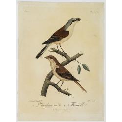
1. L'Ecorcheur mâle. 2. Femelle. Planche 64.
Very decorative plate from Histoire naturelle des oiseaux d'Afrique , published by Delachaussée. Levaillant's interest in natural history led him to explore Africa as th...
Date: Paris, 1796-1808
Le Grivetin mâle fig. 1. La Femelle fig. 2. Planche 118.
Very decorative plate from Histoire naturelle des oiseaux d'Afrique , published by Delachaussée. Levaillant's interest in natural history led him to explore Africa as ...
Date: Paris, 1796-1808
![Boats of the Friendly Islands. [together with] A Sailing Canoe of Otaheite.](/uploads/cache/30041-250x250.jpg)
Boats of the Friendly Islands. [together with] A Sailing Canoe of Otaheite.
Early view of Queen charlotte's sound, taken from "Views in the South Seas" being a very important and early views depicting scenes encountered while employed a...
Date: London, Boydell and Co., 1808

View of the harbour of Taloo, in the island of Eimeo.
John Webber View of the Harbour of Taloo on Moorea (Society Islands), from "Views in the South Seas" being a very important and early views depicting scenes enc...
Date: London, Boydell and Co., 1808
![A Toopapaoo of a Chief, with a priest making his offering to the Morai, in Huoheine. [Huaheine - the Society Islands]](/uploads/cache/30045-250x250.jpg)
A Toopapaoo of a Chief, with a priest making his offering to the Morai, in Huoheine. [Huaheine - the Society Islands]
A view of a chief's raised burial chamber in Huaheine, Society Islands, taken from "Views in the South Seas" being a very important and early view depicting sce...
Date: London, Boydell and Co., 1808

The Narta, or Sledge for burdens in Kamtschatka.
Webber's view of transport in Kamtchatka, Russia, showing the sledge dogs hooked up to the sledge, and their master on skis, taken from "Views in the South Seas"...
Date: London, Boydell and Co., 1808
![View in the island of Cracatoa. [Rakata in the Sunda Strait]](/uploads/cache/30051-250x250.jpg)
View in the island of Cracatoa. [Rakata in the Sunda Strait]
Early view of the volcano Krakatoa (Indonesian name: Krakatau), on the Indonesian island of Rakata in the Sunda Strait, taken from "Views in the South Seas" bei...
Date: London, Boydell and Co., 1808

The Fan palm, in the island of Cracatoa.
The Fan palm, on the island of Krakatoa (Indonesian name: Krakatau), in the Sunda Strait, taken from "Views in the South Seas" being a very important and early ...
Date: London, Boydell and Co., 1808
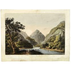
(RESERVED) A view in Oheitepeha Bay in the Island of Otaheite. (Tahiti)
A view of Vaitepiha Bay (Tahiti), with a mountainous landscape, with a river in the centre, a small canoe, Tahitian houses to the right, and a Tahitian couple in the left...
Date: London, Boydell and Co., 1808
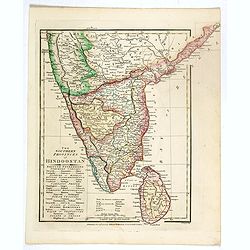
The Southern provinces of Hindoostan . . .
An attractive map showing Hindoostan and Ceylon. Shows towns, rivers, mountains, lakes, etc. In pretty original wash colors. Robert Wilkinson was active in London as a ca...
Date: London, 1808
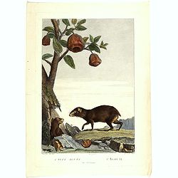
Cavia Aguti - L'Agouti - Tiers de la grandeur. (Cavia)
Fine illustration of two cavia's, from the book "Illustrations de La Ménagerie du Muséum National d'Histoire Naturelle" or "The Menagerie of the National...
- $75 / ≈ €64
Date: Paris, 1808
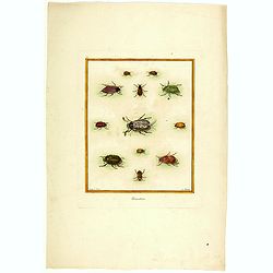
Hannetons. (Beetels)
Fine illustration of 12 beetles, from the book "Illustrations de La Ménagerie du Muséum National d'Histoire Naturelle" or "The Menagerie of the National ...
- $75 / ≈ €64
Date: Paris, 1808
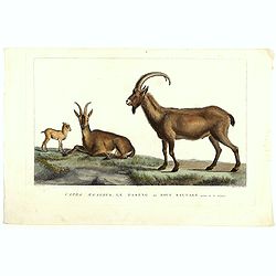
Capra Aegagrus, Le Paseng ou Bouc sauvage, Septieme de la Grandeur. (Wild goat)
Fine illustration of a Wild goats, from the book "Illustrations de La Ménagerie du Muséum National d'Histoire Naturelle" or "The Menagerie of the Nationa...
- $50 / ≈ €42
Date: Paris, 1808
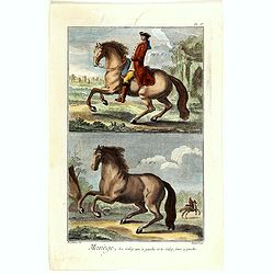
Manège, La Galop uni à gauche et le faux à gauche. (PL IV)
Copperplate engraving of horses by Robert Bénard (1734, Paris – 1777) taken from Encyclopédie de Diderot et d'Alembert.
- $60 / ≈ €51
Date: Paris, 1808
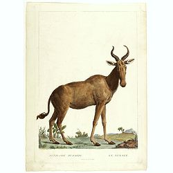
Antilope Bubalis - Le Bubale - Sisieme de la grandeur. (Antilope)
Fine illustration of an Antilope, from the book "Illustrations de La Ménagerie du Muséum National d'Histoire Naturelle" or "The Menagerie of the National...
- $75 / ≈ €64
Date: Paris, 1808
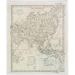
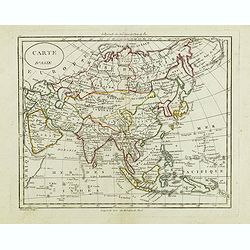
Asia, drawn from the latest Astronomical Observations.
This finely engraved, and detailed, map of Asia shows the extent of knowledge from astronomical observations at the time. It is also of interest for showing Australia her...
- $100 / ≈ €85
Date: London ca. 1808
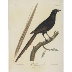
Le Piacpiac. Planche 54. Tome 2.
This is a very decorative plate from Histoire naturelle des Oiseaux d'Afrique, published by Delachaussée. Levaillant's interest in natural history led him to explore Af...
Date: Paris, 1796-1808

Karte vom Koenigreiche Ungarn mit Einschluss der Königreiche Kroazien und Slavonien dann von dem Grossfürstenthume Siebenbürgen.
Wall map of the Kingdom of Hungary in 8 sheets mounted on canvas, preserved in their original case. The map has a graduated margin and is enclosed in a simple yet decorat...
Date: Vienna, 1809
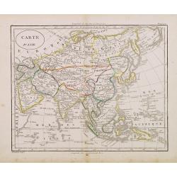
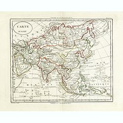
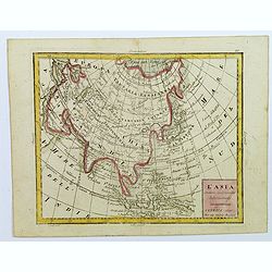
Carte d'Asie.
Fine map of Asia, with an interesting representations of Japan, Hokkaido, Sakhalin Island, Kamchatka and Korea. Engraved by Alexandre Blondeau, who also worked for Depot ...
- $150 / ≈ €127
Date: Paris, c. 1810
(Index sheet) General Tableau zur Karte von Alt Ost und West Preussen nebst dem aufgenommenen Trigonometrischen Netz. . .
Index sheet of this important multi-sheet map of Prussia, Lithuania, and Poland.Section XXIV of the rare first edition of this important 25-sheet map prepared by Friedric...
Date: Berlin, 1802-1810
(Sheet X with Puk Bay from) General Tableau zur Karte von Alt Ost und West Preussen nebst dem aufgenommenen Trigonometrischen Netz. . .
Sheet IV with Zalew Wislany and the towns of Elblag, Paslek, Braniewo, etc, of this important multi-sheet map of Prussia, Lithuania, and Poland.The rare first edition of ...
Date: Berlin, 1802-1810
Carte d'Asie.
Fine map of Asia, with an interesting representations of Japan, Hokkaido, Sakhalin Island, Kamchatka and Korea. Engraved by Alexandre Blondeau, who also worked for Depôt...
Date: Paris, c. 1810
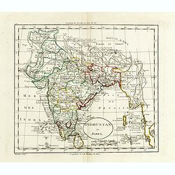
Indoustan ou Inde.
Map of India. The map is based on the Paris Meridian, only in 1884, at the International Meridian Conference in Washington DC, the Greenwich Meridian was accepted.Engrave...
- $100 / ≈ €85
Date: Paris, c. 1810
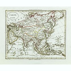
Carte d'Asie.
Fine map of Asia, with an interesting representation of Japan, Hokkaido, Sakhalin Island, Kamchatka, and Korea. Engraved by Alexandre Blondeau, who also worked for Depôt...
- $175 / ≈ €149
Date: Paris, c. 1810
Carte d'Asie.
Fine map of Asia, with an interesting representations of Japan, Hokkaido, Sakhalin Island, Kamchatka and Korea. Engraved by Alexandre Blondeau, who also worked for Depôt...
- $150 / ≈ €127
Date: Paris, c. 1810
L'Asia...
A small, uncomplicated map of Asia with outline coloring. Map extends down from the Arctic Circle to Java and New Guinea. From Arabia in the west to Japan in the east.Sma...
- $175 / ≈ €149
Date: Venezia, 1810

Karsten Niebuhr.
Stipple engraved portrait of Carsten Niebuhr or Karsten Niebuhr (1733 – 1815), published in F. J. Bertuch "Allgemeine geographische Ephemeriden".Niebuhr was a...
Date: Weimar, 1810
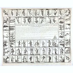
Nouveau jeu des théatres de Melpomene, Momus et Thalie.
Game board with 63 numbered pictorial compartments, each showing an actor or actress in role, lettered with his or her name, the name of the character, the play and the t...
- $1100 / ≈ €935
Date: Paris, ca. 1810
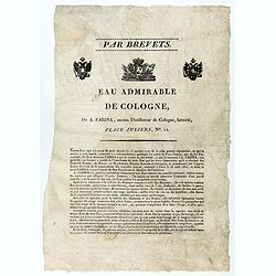
Par Brevets. / Eau admirable de Cologne, de A. Farina, ancien Distillateur de Cologne, breveté, Place Juliers, N°11.
Advertising Broadsheet promoting the toilet water "Eau de Cologne". Ornated with the royal coat of arms of France and 2 two-headed eagles. With the printed sign...
Date: After 1810
Accueil Consultation Plan du Siège de Danzig par le 10me. Corps de la Grande Armée, Avec les travaux des Français, tels qu'ils étaient le 25 Avril 1807.
A map of the siege of Danzig, 19 March-24 May 1807, showing the positions of the French siege works as they stood on 23 April. Napoleonic Wars (1803-15). Oriented with so...
Date: Paris, after 1810
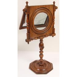
Elegant parlor Zograscope or optical mirror.
Rare so-called zograscope or optical mirror. A zograscope is an optical device for enhancing the sense of depth perception from a flat picture. It consists of a large mag...
- $1500 / ≈ €1275
Date: France or England, c. 1790-1810
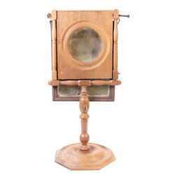
Elegant parlor Zograscope or optical mirror.
Rare so-called zograscope or optical mirror. A zograscope is an optical device for enhancing the sense of depth perception from a flat picture. It consists of a large mag...
- $1500 / ≈ €1275
Date: France or England, c. 1790-1810
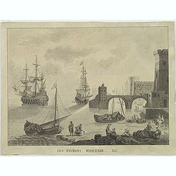
Les environs d'Ostende. XII.
Beautiful view of Oostende. A somewhat fanciful depiction of the harbor of Oostende, with merchant on the foreground and large vessels in the sea. The item is signed (Dre...
Date: Belgium, c. 1811

Carte von West=Gallizien welche auf allerhöchsten Befehl Seiner Kaiserlich oesterreichischen und Königlich apostolischen Majestät in den Jahren 1801 bis 1804. . .
Important early map of Western Galicia, as given to Austria by the third Partition of Poland (1795). Due to its lengthy development period, a rare map rich in detail depi...
Date: Vienna, (1808) after 1811
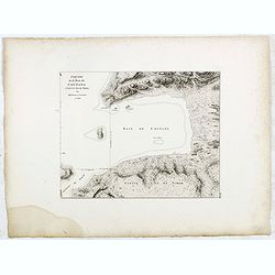
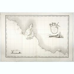
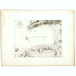
Esquisse de la Baie de Coupang (cote S.O. Ile de Timor) par M. M. Peron et Lesueur, an 1803.
Map of Kupang Bay on the Indonesian Island Timor, prepared by Louis Freycinet during his voyage under Captain Thomas Baudin in 1800-1803. Plate no. 14 from the atlas part...
- $100 / ≈ €85
Date: Paris, Langois, 1811
![[Title page] Voyage de découvertes aux terres Australes éxécuté par ordre de S.M l'Empereur et Roi.](/uploads/cache/39732-250x250.jpg)
[Title page] Voyage de découvertes aux terres Australes éxécuté par ordre de S.M l'Empereur et Roi.
Set of two title pages from the atlas part of "Voyage de decouvertes aux terres australes", Freycinet and Peron's accounts of the French cartographic expedition...
Date: Paris, Langois, 1811
Carte Generale de la Terre Napoleon (à la Nouvelle Hollande)... par M.L. Freycinet an 1808.
Fine map of part of Australia prepared by Louis Freycinet during his voyage under Captain Thomas Baudin in 1800-1803. The longitude is calculated from Paris.The cartouche...
- $4000 / ≈ €3400
Date: Paris, Imprimerie Royale, 1811
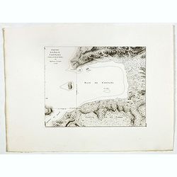
Esquisse de la Baie de Coupang (cote S.O. Ile de Timor) par M. M. Peron et Lesueur, an 1803.
Map of Kupang Bay on the Indonesian Island Timor, prepared by Louis Freycinet during his voyage under Captain Thomas Baudin in 1800-1803. Plate no. 14 from the atlas part...
- $150 / ≈ €127
Date: Paris, Langois, 1811
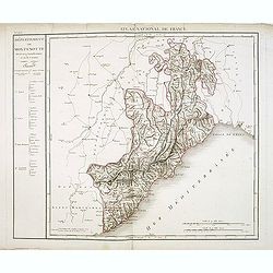
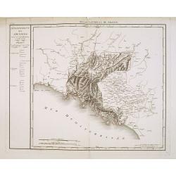
Département de Montenotte Divisé en 4 arrondissemens et en 30 cantons.
Published in the "Atlas National de France" at Chanlaire. Engraved by P.A.F. Tardieu. Represents the department of Apennines which was under French administrati...
Date: Paris, 1790-1811
Département des Apennins Divisé en 3 Arrondissemens et en 18 cantons.
Published in the "Atlas National de France" at Chanlaire. Engraved by P.A.F. Tardieu. Represents the department of Apennines which was under French administrati...
Date: Paris, 1790-1811
Esquisse de la Baie de Coupang (cote S.O. Ile de Timor) par M. M. Peron et Lesueur, an 1803.
Map of Kupang Bay on the Indonesian Island Timor, prepared by Louis Freycinet during his voyage under Captain Thomas Baudin in 1800-1803. Plate no. 14 from the atlas part...
Date: Paris, Langois, 1811
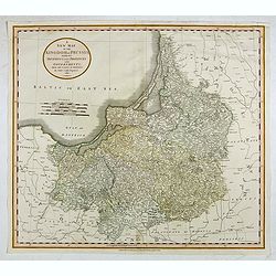
A New Map of the Kingdom of Prussia with its Divisions Into Provinces and Governments. . .
A fine map by John Cary of Prussia, in what is now northern Poland and Lithuania. John Cary was considered "the most representative, able and prolific of English car...
- $250 / ≈ €212
Date: London, 1811
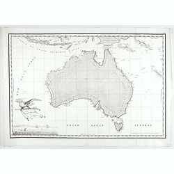
Carte Generale de la Nouvelle Hollande.
Fine map of the continent of Australia prepared by Louis Freycinet during his voyage under Captain Thomas Baudin in 1800-1803. Freycinet's map of New Holland was the firs...
- $5000 / ≈ €4249
Date: Paris, Imprimerie Royale, 1811

Voyage de découvertes aux Terres Australes. Historique. Atlas Deuxième partie.
First edition of the second part of the atlas by Freycinet, part of his important book "Voyage de découvertes aux Terres Australes". Illustrated with two foldi...
- $7500 / ≈ €6374
Date: Paris, Langlois, 1811
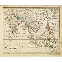
Ostindien.
Nice small map of South East Asia published by Johannes Walch in his rare Allgemeiner Atlas Nach den bewährsten Hülfsmitteln und astronomischen Ortsbestimungen…, edit...
- $160 / ≈ €136
Date: Augsburg, 1812
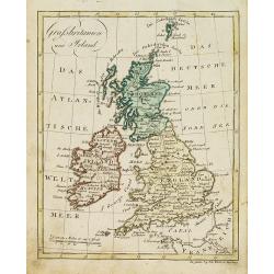
Grossbritanien und Irland.
Nice small map of the British isles and Ireland by Johannes Walch in his rare Allgemeiner Atlas Nach den bewährsten Hülfsmitteln und astronomischen Ortsbestimungen…, ...
- $50 / ≈ €42
Date: Augsburg, 1812
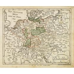
Deutschland (with Poland)
Nice small map of Germany by Johannes Walch in his rare Allgemeiner Atlas Nach den bewährsten Hülfsmitteln und astronomischen Ortsbestimungen…, edition of 1812.Johann...
- $75 / ≈ €64
Date: Augsburg, 1812
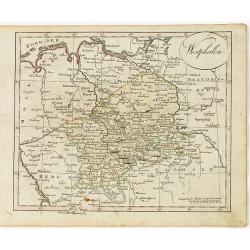
Westphalen.
Nice small map of Westphalia in Germany by Johannes Walch in his rare Allgemeiner Atlas Nach den bewährsten Hülfsmitteln und astronomischen Ortsbestimungen…, edition ...
- $50 / ≈ €42
Date: Augsburg, 1812
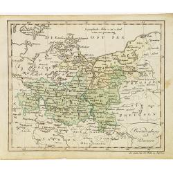
Brandenburg und Pommern.
Nice small map of Brandenburg and Pommeren, centered on Berlin by Johannes Walch in his rare Allgemeiner Atlas Nach den bewährsten Hülfsmitteln und astronomischen Ortsb...
- $75 / ≈ €64
Date: Augsburg, 1812
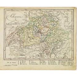
Schweiz.
Nice small map of Switzerland by Johannes Walch in his rare Allgemeiner Atlas Nach den bewährsten Hülfsmitteln und astronomischen Ortsbestimungen…, edition of 1812.Jo...
- $60 / ≈ €51
Date: Augsburg, 1812