Browse Listings
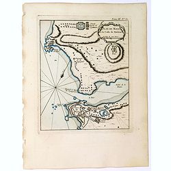
![[69] Barbarie.](/uploads/cache/12841-250x250.jpg)
[69] Barbarie.
Charming chart of the harbour of the province of Barbarie in Syria. Showing town and harbour plan, with soundings, anchorages, rocks, shoals, fortifications and lighthous...
Date: Marseille 1764
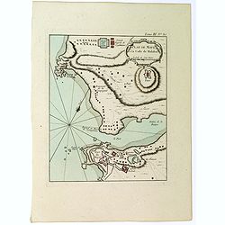
![[71] Barbarie.](/uploads/cache/12843-250x250.jpg)
[71] Barbarie.
Charming chart of the harbour of the province of Barbarie in Syria. Showing town and harbour plan, with soundings, anchorages, rocks, shoals, fortifications and lighthous...
Date: Marseille 1764
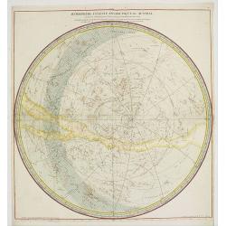
Hemisphere Celeste Antarctique ou Austral. . .
Map printed in two colors, black for the stars, red for the constellation figures. With later color addition.Uncommon large-scale celestial chart of the southern hemisphe...
- $750 / ≈ €637
Date: Paris, 1764

Plan du Port de St Augustin dans la Floride.
This chart shows a plan of the Port of St. Augustine in Florida.The only issue of this version of Bellin's map, slightly larger than the common version. Depths shown by s...
Date: Paris, 1764

Ajustement des Femmes de Valday Situé entre Petersbourg et Moscou.
Etching by Jean-Baptiste Le Prince (1734-1781), from "2me Suite de divers cris de marchands de Russie", showing typical russian customs. The sketches Le Prince ...
- $110 / ≈ €93
Date: Paris, 1764
![[Title page] Schauplatz des gegenwaertigen kriegs. . .](/uploads/cache/12307-250x250.jpg)
[Title page] Schauplatz des gegenwaertigen kriegs. . .
Title page from Schauplatz des gegenwaertigen kriegs. Very fine, typical German title page with cannons, flags, trumpets, etc.Gabriel Nikolaus Raspe (1712-1785) was activ...
- $250 / ≈ €212
Date: Nuremberg, 1757-1764
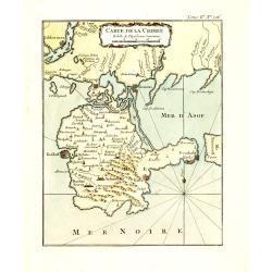
Carte de la Crimée.
Fine map of Crimea (Ukraine) here in the only issue of this version of Bellin's map, slightly larger than the common version. From Bellin's Le Petit Atlas Maritime Recuei...
Date: Paris, 1764
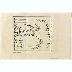
Karte von den neuen philippinen.
Small map of the southern Philippines. In: "Allgemeine Historie der Reisen zur Wasser und zu Lande: oder Sammlung aller Reisebeschreibungen.. in Englischen zusammen ...
- $200 / ≈ €170
Date: Leipzig, Arkstee und Merkus, 1764
(Tableau d'explication des marques, p12)
Key sheet to a rare atlas of the province of Normandy " Atlas de la Province de Normandie dédié à Mr Thiroux de Crosne . . ." dedicated to Mr. Thiroux Crosne...
- $50 / ≈ €42
Date: Paris, 1764
Plan de Maye a la Coste de Malabar.
From Bellin's "Le Petit Atlas Maritime", a plan of the bay of Maye, off the Malabar coast of southern India. Map relief shown pictorially. Shows settlements, po...
- $100 / ≈ €85
Date: Paris, 1764
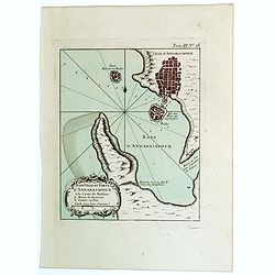
Baye Ville et Forts d'Andarajapour a la Coste de Malabar.
From Bellin's popular "La Petit Atlas Maritime", showing the bay, fort and town of Andarajapour in the Malabar region of India. The map is furnished with a comp...
- $110 / ≈ €93
Date: Paris, 1764
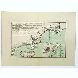
Coste de Coromandel depuis Gondagamas jusqu'a Narzapour.
This map is taken from Bellin'spopular 'Petit atlas maritime'. It shows a portion of the Indian coastline in the region of Coromandel from Montepdly through Mazulipatam o...
- $110 / ≈ €93
Date: Paris, 1764
Plan de Maye a la Coste de Malabar.
From Bellin's 'Le Petit Atlas Maritime', a plan of the bay of Maye, off the Malabar coast of southern India. Relief shown pictorially. It shows settlements, ports, and ma...
- $85 / ≈ €72
Date: Paris, 1764
![[Title page] Le Petit Atlas Maritime recueil de cartes et plans. . .](/uploads/cache/47754-250x250.jpg)
[Title page] Le Petit Atlas Maritime recueil de cartes et plans. . .
Title page of "Le Petit Atlas maritime recueil de cartes et plans des quatre parties du Monde - Cinquieme volume contenant Les costes de France" by Jacques Nic...
- $150 / ≈ €127
Date: Paris, 1764
Le Petit atlas maritime. Recueil de cartes et plans des quatre parties du monde, en cinq volumes.
FIRST EDITION. A large paper copy, in attractive original colors. Jacques Nicolas Bellin held offical status as royal hydrographer and ingéniuer géographe de la marine ...
- $45000 / ≈ €38245
Date: Paris, 1764
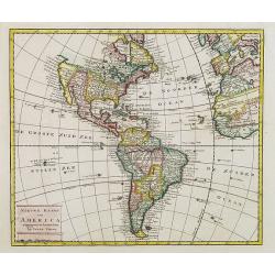
Nieuwe kaart van America.
An attractive map of both the Americas, by one of the leading mapmakers in 18th century Amsterdam. Isaak Tirion (d. 1769) was a Amsterdam publisher. His "Nieuwe en b...
- $400 / ≈ €340
Date: Amsterdam, 1765

Het stadhuis, van vooren.
The former Amsterdam Town Hall, now the Royal Palace. Copper engraving by Frans de Bakker after Reinier Vinkeles (1741-1816).From the well-known description of Amsterdam ...
Date: Amsterdam, 1765
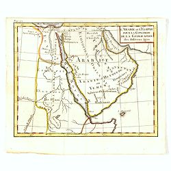
l'Arabie et l'Egypte pour la Concorde de la Géographie des different Ages.
Uncommon map of Arabian Peninsular with a title inland "Arabie Heureuse. . .".More about Mapping of Arabia [+]
Date: Paris, 1765
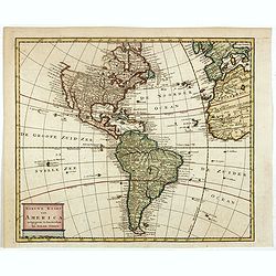
Nieuwe kaart van America.
An attractive map of both the Americas, by one of the leading mapmakers in 18th century Amsterdam. Isaak Tirion (d. 1769) was a Amsterdam publisher. His "Nieuwe en b...
Date: Amsterdam, 1765
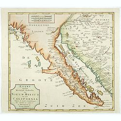
Kaart van het Westelyk Gedeelte van Nieuw Mexico en van California. . . MDCCLXV ..
A detailed map of the Baja California and Sonora, bounded on the north by the Colorado and Gila Rivers and approximately Mozatlan in the south, thus including parts of mo...
Date: Amsterdam, 1765
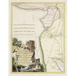
![Plan de Gingy, ville et forteresse d'Asie . . . [An Early Manuscript Map of Pondicherry Prior To Its Reconstruction After The Seven Years War.]](/uploads/cache/43006-250x250.jpg)
Plan de Gingy, ville et forteresse d'Asie . . . [An Early Manuscript Map of Pondicherry Prior To Its Reconstruction After The Seven Years War.]
An early manuscript map of Gingy shortly after The Seven Years War, when the French took possession of large part of India.With an extensive key to the left.Gingee Fort o...
- $1500 / ≈ €1275
Date: Paris, 1765
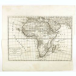
L'Afrique divisée en ses principaux etats par le Sr. Janvier Geographe.
A neatly engraved example of Jean Janvier's 1762 map of Africa. Covers the entire continent as well as the Island of Madagascar and adjacent parts of Persia and Arabia. D...
- $200 / ≈ €170
Date: Paris, ca. 1765
Carte de la Babylonie nommée aujourd'hui Hierac-Arab avec les noms, tant anciens que modernes et les routes des expéditions de Cyrus et de Julien l'Apostat, aussi bien que celles de Teixera, Benjamin. . .
A very fine map centered on Arabia and in top Iraq with Baghdad. With a very attractive title cartouche on the lower left-hand corner. Published by Joseph-Nicolas De l' I...
- $550 / ≈ €467
Date: Paris/ Bordeaux, 1766
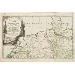
Nouvelle carte géographique des postes et autres routes d'Allemagne. . .
Map showing the northern provinces in Germany and part of the Netherlands. Decorative title cartouche in the upper left corner. A so-called post road maps.
- $80 / ≈ €68
Date: Paris, 1766
Bataille du Johansberg Gagnée par son Altesse Sérénissime Monseigneur le Prince de Condé . . . Le 30 Aoust 1762 . . .
Five detailed military battle-plans showing the four stages in the siege of Johansburg and the battle plan around Grüningen published by Jean de Beaurain (1696–1771) ....
- $150 / ≈ €127
Date: Paris, 1766
![Grond-beginzels der stuurmans-konst. . . [bound with] De tafelen sinuum tangentium en secantium. [Bound with] Tafelen logarithmi der hoekmaaten, raaklynen en snylynen.](/uploads/cache/33119-250x250.jpg)
Grond-beginzels der stuurmans-konst. . . [bound with] De tafelen sinuum tangentium en secantium. [Bound with] Tafelen logarithmi der hoekmaaten, raaklynen en snylynen.
An early instruction boek for the sailor prepared by Pybo Steenstra, who the official examinator of the V.O.C.. Published by Joannes van Keulen and sons. It is clear that...
Date: Amsterdam, Joannes van Keulen, n.d. 1766

Carta Topografica dell' Isola Del Maritaggio di Monsieur le Boble per la prima volta. Tradotta dal francese in italiano.
Second Italian printing of Eustache Le Noble’s "Carte de l’isle de marriage." The book’s text offers instructions on how to reach this matrimonial island ...
Date: Cosmopoli, 1766

America settentrionale. . .
Rare map of North America drawn directly from the work of Nicholas De Fer and N. Sanson's famous map of 1650. The map is engraved by Antonius Donzel Gallus.With open Grea...
Date: Napels, 1766
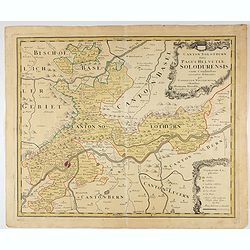
Canton Solothurn sive pagus Helvetiae Solodurensis cum confinibus recenter delineatus per Gabrielem Walserum.
A nice map of Swiss canton centered on Solothurn. Engraved by Tobias C. Lotter.
Date: Augsbourg, 1766
![[Title page] Recueil des côtes maritimes de France. . .]](/uploads/cache/47737-250x250.jpg)
[Title page] Recueil des côtes maritimes de France. . .]
Title page of Recueil des côtes maritimes de France by Louis Brion De La Tour in 1766, and published by Desnos in Paris. With a decorative shipping scene in the lower pa...
- $175 / ≈ €149
Date: Paris, 1766
![[Title page] Atlas général, civil, ecclesiastique et militaire. . .](/uploads/cache/47738-250x250.jpg)
[Title page] Atlas général, civil, ecclesiastique et militaire. . .
Title page of Recueil des côtes maritimes de France by Louis Brion De La Tour in 1766, and published by Desnos in Paris.
- $200 / ≈ €170
Date: Paris, 1766
![[Title page] Recueil des côtes maritimes de France. . .](/uploads/cache/48140-250x250.jpg)
[Title page] Recueil des côtes maritimes de France. . .
Title page of Recueil des côtes maritimes de France by Louis Brion De La Tour in 1766, and published by Desnos in Paris. With a decorative shipping scene in the lower pa...
- $150 / ≈ €127
Date: Paris, 1766
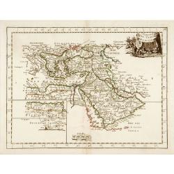
L'Empire des Turcs.
With decorative title cartouche upper right. Good detail in the Arabian peninsula.More about Mapping of Arabia [+]
Date: Paris, 1767
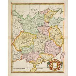
La Chine.
With decorative title cartouche lower right. Good detail of China's mainland with Taiwan and Hainan Province.
- $300 / ≈ €255
Date: Paris, 1767

Carte Réduite De La Partie Septentrionale De L'' Isle De Terre Neuve..
A well engraved and highly detailed chart, corrected to 1767. Elaborate hand-colored cartouche, rhumb lines.Shows northern part of Newfoundland and southern coast of Labr...
Date: Paris, 1767
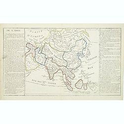
De l'Asie. . .
On the left and on the right two explication cartouche. The text is in French, interesting for its documentation of contemporary European attitudes and preconceptions reg...
- $300 / ≈ €255
Date: Paris, ca. 1767
![Plans de Quelques Villes de la Province de Hou-Quang. / Grondtekening [floor plan] van eenige Steden van't Landschap Hu-Quang.](/uploads/cache/34078-250x250.jpg)
Plans de Quelques Villes de la Province de Hou-Quang. / Grondtekening [floor plan] van eenige Steden van't Landschap Hu-Quang.
Interesting set of three local town plans each with extensive titles :"Yong Chew Fu, ou Yong Tcheou Fou." Centre: "Vu Chang Fu, ou Vou-Tchang-Fou Capitale:...
Date: The Hague, Pieter de Hondt, 1747-1767
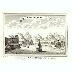
Cité de Nang Hyong Fu, tiree the Nieuhof. De Stad van Nan-Hyong-Fu, uit Nieuhof.
Interesting view of Nan-Hyong-Fu with harbour and fort.Prepared by Jacques Nicolas Bellin and included in a Dutch edition of Prévost d' Exile's "Histoire des Voyage...
Date: The Hague, Pieter de Hondt, 1747-1767
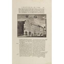
t'Oost-Indisch-Huys.
A decorative print of the East Indian House, the headquarters of the V.O.C., a place for meeting, trading and storage of spices and ship equipment. The maps and charts we...
- $150 / ≈ €127
Date: Amsterdam, 1760-1767
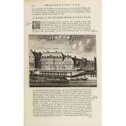
s'Lands en Oost-Indische Lynbanen.
A decorative print of the Lynbanen a place were V.O.C. ship riggings and ropes were produced and kept.From J.Wagenaar: Amsterdam in zijne opkomst, aanwas, geschiedenisse....
- $100 / ≈ €85
Date: Amsterdam, 1760-1767

The Harbour of Casco Bay and Islands Adjacent Bt Capt. Cyprian Southicke.
The earliest printed chart of Casco Bay, an inlet of the Gulf of Maine on the southern coast of Maine, New England. First issued in 1720 by Mount and Page, it remained in...
Date: Dublin, 1767
Royaume de Pologne.
Fine map of Lithuania, Prussia and Poland with an explicatif text to both sides. From Jean Baptiste Louis Clouet (1730-1790) influential "Géographie Moderne" f...
Date: Paris, ca. 1767
![[Title page Geographie moderne avec une introduction. . .]](/uploads/cache/47739-250x250.jpg)
[Title page Geographie moderne avec une introduction. . .]
Engraved title page and a text sheet from Jean Baptiste Louis Clouet (1730-1790) influential "Géographie Moderne" first published in 1767 and reissued in sever...
Date: Paris, 1767
![[Title page] Atlas nouveau portatif à l'usage des militaires college et du voyageur. . .](/uploads/cache/47746-250x250.jpg)
[Title page] Atlas nouveau portatif à l'usage des militaires college et du voyageur. . .
Title page of Atlas nouveau portatif à l'usage des militaires college et du voyageur by Étienne Louis Crepy in 1767.More about title pages [+]
- $175 / ≈ €149
Date: Paris, 1767

Expulsion et Embarquement des Jesuites des Etats d’Espagne, Par Ordre de S.M.C. le 31 Mars 1767
A large and rare print on the subject of the Expulsion of the Jesuits from Spain and its colonies by Charles III.In the wake of France, the Bourbons of Spain and Italy in...
- $400 / ≈ €340
Date: Paris, 1767

s'Lands en Oost-Indische Lynbanen.
A decorative print of the Lynbanen a place were V.O.C. ship riggings and ropes were produced and kept.
Date: Amsterdam, 1760-1767

t'Oost-Indisch-Huys.
A decorative print of the East Indian House, the headquarters of the V.O.C., a place for meeting, trading and storage of spices and ship equipment. The maps and charts we...
Date: Amsterdam, 1760-1767

s'Lands en Oost-Indische Lynbanen. & t'Oost-Indisch-Huys.
A decorative print of the Lynbanen a place were V.O.C. ship riggings and ropes were produced and kept.
Date: Amsterdam, 1760-1767
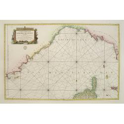
Carte réduite du Golphe de Genes. Conenant partie des cotes de Provence, celles de Piemont, de Genes et de Toscane . . .
Superb sea chart covering the coasts of the French and Italian Riviera's, Tuscany and northern tip of Corsica, prepared by Jacques Nicolas Bellin (1703-1772) the Royal Hy...
Date: Paris, 1768
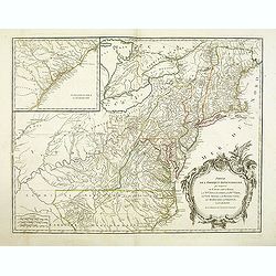
Partie De L'Amerique Septentrionale... Le Cours De L'Ohio, La N.lle Angleterre, a Nlle York, le New Jersey , La Pensyvanie, Le Maryland, Le Virginie, La Carolina...1755
From the Atlas Universel , a detailed map extending the length of the east coast from Penobscot Bay to Cape Fear and, in an inset, from Cape Fear to Fort St.Georges.This ...
- $800 / ≈ €680
Date: Paris, 1768

Vermakelykheden van Brabant, en deszelfs onderhoorige Landen... (2 volumes)
Topographical and iconographical work on Brabant illustrated with 1 engr. title-vignette and 190 engraved views, plans & armorial plates by J. Harrewijn, G. Bouttats ...
Date: Amsterdam, P.J. Entrop, 1768
![[Title page] Atlas général, civil et ecclésiatique . . .](/uploads/cache/41595-250x250.jpg)
[Title page] Atlas général, civil et ecclésiatique . . .
Title page of the third edition of the world atlas by Brion De La Tour.
- $75 / ≈ €64
Date: Paris, 1768
Charta exhibens Situm antiquum Carthaginis, Uticae. . . / A Bird's View of the Situation of Antient Carthage.
A pair of engravings of ancient Carthage in North Africa, from Charles Rollins' "The Ancient History of the Egyptians, Carthaginians, Assyrians, Babylonians, medes &...
- $50 / ≈ €42
Date: London, ca 1768
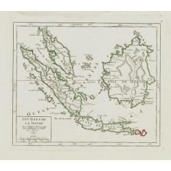
Les Isles de la Sonde.
Small detailed map of southeast Asia, showing the Malay Peninsula, Sumatra, Java and the island of Borneo. Dated 1769.From Atlas Portatif Universel, by Robert de Vaugondy...
- $200 / ≈ €170
Date: Paris, later than 1769
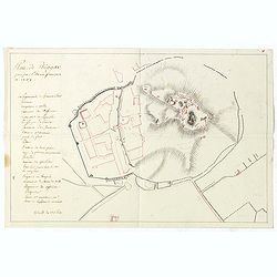
![[manuscript plan] Siège de Schweidnitz en Silésie fait par les trouppes Imperial es commandées par Mr. le de Nadasti ...](/uploads/cache/39893-250x250.jpg)
[manuscript plan] Siège de Schweidnitz en Silésie fait par les trouppes Imperial es commandées par Mr. le de Nadasti ...
This fine manuscript shows the layout of the city of Swidnica with its surrounding defence wall, its advanced bastions and suburbs, roads and two nearby villages. In lowe...
- $2750 / ≈ €2337
Date: France, 1769

Nouveau théâtre de la guerre entre les Russes les turcs et les polonois confédérés.
A very rare separately published map of Crime region. With a large title cartouche lower left "Nouveau theâtre de la guerre entre les russes, les turcs et les polon...
Date: Paris, 1769

Nieuwe Kaart van de Grootbrittannische Volkplantingen in Noord America waar in Tevens de Fransche Bezittingen en de Landen tuschen die Beide Volken. . .
A map of the east-coast of America from New Foundland till Florida, divided in French and British properties. Reduced size Dutch edition of Mitchell's map of North Americ...
Date: Amsterdam, 1769

Nieuwe kaart van Kanada . . .
Nice map of the Bay of Hudson, In Labrador, a small inset of Nova Scotia. The map is dated 1769. All text is in Dutch. The map shows the region shortly after the conclusi...
Date: Amsterdam, 1769
Plan général de Reims et de ses Environs Dédié au Roi.
Rare wall map of a plan of Reims engraved by Jean Lattré. Central cartouche included in the lower border, composed of the coat of arms of France and Navarre, surmounted ...
- $2500 / ≈ €2125
Date: Paris, Lattré, 1769
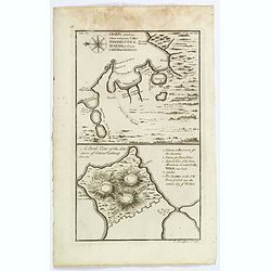
Plan de Thiagar, prise par l'arméé française en 1759.
An early manuscript map of Thiagar. With an extensive unfinished key to the left. The map was drawn shortly after the end of the Seven Years War, when the French took pos...
- $750 / ≈ €637
Date: Paris, 1769
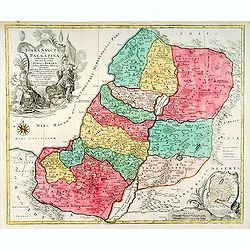
Terra Sancta sive Palaestina. . .
Map of Palestine divided among the Tribes on both sides of Jordan and into Kingdoms of Judah and Israel. Cartouche at bottom right features a small map of the Exodus.T.C....
- $750 / ≈ €637
Date: Augsbourg, 1770
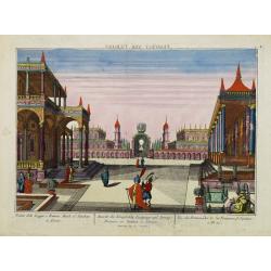
Vue des Promenades et les Fontaines d'Ispahan.
Carmine was a well-known publisher of optical prints, established in Augsburg.Isfahan was once one of Central Asia's largest and most important cities, at the crossroads ...
Date: Augsburg 1770

Plan der Stadt Quebec Haupstadt in Neu Franckreich oder Canada.
Town-plan of Quebec, with an inset view of the town in the lower right corner. In the upper right a recapitulation of the main military actions prior to the surrender of ...
Date: Nurnberg, 1770
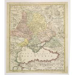
Tabula Geographica qua pars Russiae Magnae. . .
An unrecorded state Homann's map is based upon the works of George von Mengden (1628-1702), a Livonian cartographer who worked for Peter the Great and Count Jacob Bruce [...
Date: Nuremberg, c. 1770
(Berlin) Prospectus Armamentarii regnii versus arcem principis regis haereditarii Berolini.
A square in Berlin. In the eighteenth and nineteenth centuries there were many popular speciality establishments in Paris, Augsburg and London which produced optical view...
- $200 / ≈ €170
Date: Italy, 1770
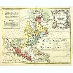
America Septentrionalis, Concinnata juxta Observationes..
This exemplar represents Lotter's version of Delisle's foundation map of North America, published in 1700. The Great Lakes show the French strong holds at Quebec, Montrea...
- $875 / ≈ €744
Date: Augsburg, ca. 1770
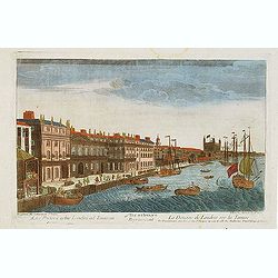
Vue d'optique representant La Douane de Londres sur la Tamise. . .
Showing the Customs office in London seen from the River Thames. Published by Daumont, who was a well-known publisher of optical prints, established in rue St. Jacques in...
- $200 / ≈ €170
Date: Paris, ca. 1770
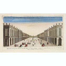
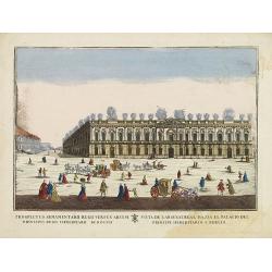
Elevation perspective de la nouvelle place de Petersbourg suivant le projet . . .
Showing a perspective view of the new Palace Square in St. Petersburg. In the 1760s, the Baroque architecture was succeeded by neoclassical architecture.This so-called op...
- $200 / ≈ €170
Date: Paris, ca. 1770
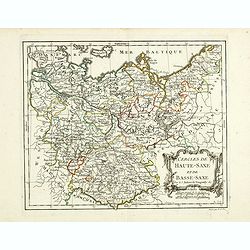
Cercles de Haute-Saxe et de Basse-Saxe.
Early edition of this fine map of the duchies of Saxony (upper & lower), including part of present-day Poland. Published in "Atlas Portatif de Vaugondy".Cha...
- $75 / ≈ €64
Date: Paris, ca.1770
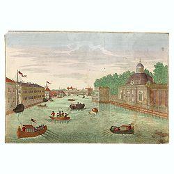
(Hof, Voraths-Magazin, am Fontanka Flus, Zu Petersburg.)
So-called optical print illustrating a perspective view of the river Fontanka in Saint Petersburg. The Fontanka is a branch of the Neva river. At the right of the print w...
- $225 / ≈ €191
Date: Augsburg, c.1770
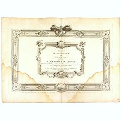
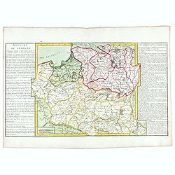
(Title page) Atlas de la Province de Normandie dédié à Mr Thiroux de Crosne . . .
Title page to a rare atlas of the province of Normandy "Atlas de la Province de Normandie dédié à Mr Thiroux de Crosne . . ." dedicated to Mr. Thiroux Crosne...
Date: Paris, ca. 1770
Almanach géographique ou petit atlas élémentaire composé de Cartes générales et particulières des différens Empires, Royaumes et Républiques de l'Europe. . .
Charming almanac with two engraved dedication and title page, portrait of Christian VII. Roy de Dannemarck et de Norvège.The map of Asia is of interest for the use of Ko...
- $3000 / ≈ €2550
Date: Paris, 1770
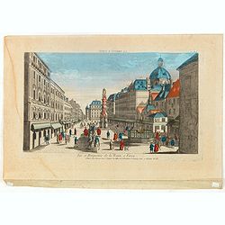
Vue et Perspective de la Trinité a Vienne.
Decorative perspective view of a square in Vienna centered on the column which represents the Trinity. Published by Jacques François Chereau [1742 -1794], who was active...
- $100 / ≈ €85
Date: Paris, 1770
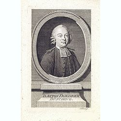
Danton Fridrich Büsching.
Copper engraved portrait of the geographer Anton Friedrich Büsching (1724–1793), engraved by Johann David Schleuen ( (active 1740-1774). Büsching was a celebrated Ger...
- $200 / ≈ €170
Date: Hamburg, ca. 1770
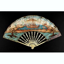
A folding fan showing a nautical festival, ca. 1770.
Folded fan, painted in gouache a ship pulled by two horses. On board, a large company, among others joins them while fishermen watch the scene.Reverse painted with an exo...
- $1500 / ≈ €1275
Date: France, ca. 1770
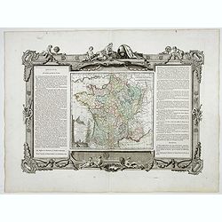
La France Divisée en ses quarante gouvernemens . . .
Map of France surrounded by a decorative frame.
Date: Paris, 1770
![Almanach Géograhique ou petit atlas.. [Seconde partie]](/uploads/cache/48945-250x250.jpg)
Almanach Géograhique ou petit atlas.. [Seconde partie]
The second part of this uncommon miniature atlas with extensive geographical descriptions of mainly European countries.Including map of France; Netherlands; Belgium; Spai...
Date: Paris, 1770
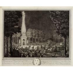
Réjouissances du Peuple près de la Pyramide d'Illumination, élévée sur l'Esplanade de la Porte de Mars et Distribution de Vivres, fontaines de Vin , sous les Ordres de Mrs. Du Conseil de la Ville, à Reims le 27 Aoust 1765.
Engraved by Varin after Moreau Jr. The print shows a lightning spectacle held in Reims on 27 August 1765.
Date: Paris, 1771
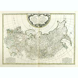
Partie Occidentale de l'Empire de Russie. . . / Partie Orientale de l'Empire de Russie. .
Attractive map of Russia, ornated with a rococo title cartouche. Boundaries outlined in hand color.The detailed map covers from the Baltic Sea to Siberia and the Bering S...
- $400 / ≈ €340
Date: Paris, ca 1771
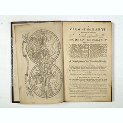
A view of the earth : being a short but comprehensive system of modern geography graphy ...
The Third Edition. First work with seven engraved maps (including a twin-hemisphere world map, continents), plate of a globe, engraved illustrations in the text including...
Date: London, S. Crowder and S. Gamidge, 1771