Browse Listings in Europe > Switzerland > Switzerland General
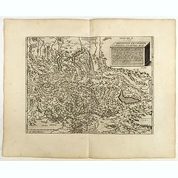
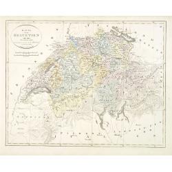
Helvetiae Descriptio . . .
A fine map based upon a map by the Swiss cartographer Aegidicus Tschudi of 1538.Dare to go in Black. All early maps are printed in black and white and many were kept that...
Date: Antwerp, 1598
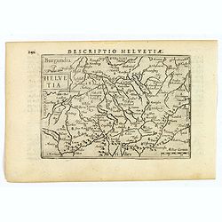
Helvetia.
A lovely miniature map of Switzerland, published by Petrus Bertius, in Amsterdam at the beginning of the seventeenth century.Full of facinating topographical detail, and ...
Date: Amsterdam, 1606

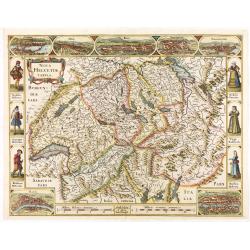
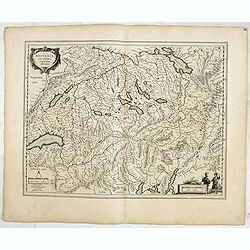
Nova Helvetiae Tabula.
A most decorative "carte à figures" map with panoramic views of Lucern, S.Gal, Bern, Solothurn, Schafhausen in upper border and Basel and Zurich in lower left a...
Date: Amsterdam, 1630
Helvetia cum finitimis regionibus confoederatis.
Detailed and finely engraved map of Switzerland.
Date: Amsterdam, 1630
Nova Helvetiae Tabula.
A most decorative "carte à figures" map with panoramic views of Lucern, S.Gal, Bern, Solothurn, Schafhausen in upper border and Basel and Zurich in lower left a...
Date: Amsterdam, 1630
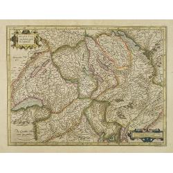
Helvetia cum finitimis regionibus confoederatis.
Detailed and finely engraved map of Switzerland with a pair of fine cartouches.From early on Willem Jansz. Blaeu aimed of publishing an atlas to compete with the Hondius-...
Date: Amsterdam, 1634
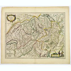
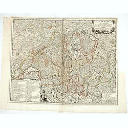
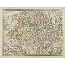
Helvetia cum finitimis regionibus confoederatis.
A typically detailed and finely engraved map of Switzerland by Blaeu, including the cities of Basel, Zürich, Bern, Lucerne, Fribourg, etc. The map is embellished with two...
Date: Amsterdam, 1643
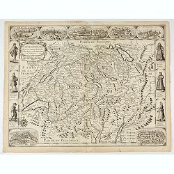
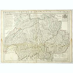
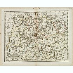
Carte generale des treze cantons de Suisses. Valley Ligues Grise, Maison Dieu et Valteline. 1654
Rare figured border map of Switzerland. In lower corners views of Basel and Zurich. In the top views of Luzern, St. Gallen, Bern, Solothurn and Schaffhausen. In the left ...
Date: Paris, ca. 1654
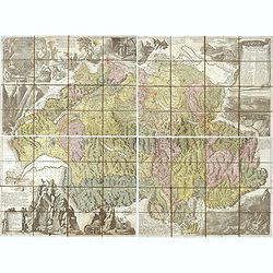
Nova Helvetiae tabula geographica . . .
Johann Jakob Scheuchzer (August 2, 1672 – June 23, 1733) was a Swiss scholar born at Zürich. In 1712 he published, a map of Switzerland in four sheets (scale 1/290,000), ...
- $1750 / ≈ €1530
Date: Amsterdam, 1712
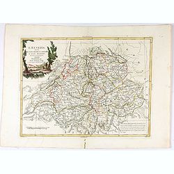
Carte de Suisse ou sont les Cantos de. . .
General map of Switzerland with all the cantons good detail, with the imprint "A Paris Chez l’Auteur sur le Quai de l’Horloge Avec Privilège Aout 1715". In the ...
Date: Paris, Aout 1715
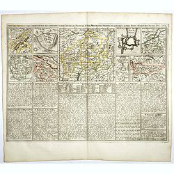
Carte des Grisons et des Communautez qui Composent leurs Ligues, les Etats de St. Gal, Neuchastel, Geneve et Quelques Autres Etats Alliez des Suisse.
This finely engraved sheet provides the history of various cities and regions allied with Switzerland at the beginning of the eighteenth century. The top section of the s...
- $150 / ≈ €131
Date: Amsterdam, 1720
![[Lot of 3 maps] Carte de la Souveraineté de NEUCHATEL et VALLANGIN. Plus Mercator's and Blaeu's maps of the Wiflispurgergou]](/uploads/cache/18600-250x250.jpg)
[Lot of 3 maps] Carte de la Souveraineté de NEUCHATEL et VALLANGIN. Plus Mercator's and Blaeu's maps of the Wiflispurgergou]
Map of the lake of Neuchatel by Covens & Mortier. After the death of the widow of Pieter Mortier in 1719, the firm continued till 1778 as Covens & Mortier. They ...
- $350 / ≈ €306
Date: Amsterdam, c. 1745
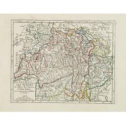
Les Suisses, les Alliés des Suisses et leurs Sujets.
Small detailed map of Switzerland. From Atlas Portatif Universel, by Robert de Vaugondy.Unrecorded state with erased date. Page 31 outside border top right. Mary Sponberg...
Date: Paris, later than 1749
Les Suisses leurs sujets et leurs alliez. . .
Un uncommon map of Switzerland by Nolin.
- $250 / ≈ €219
Date: Paris, ca. 1760
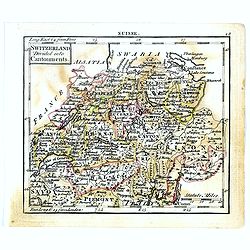
Switzerland divided into Cantonments.
Uncommon miniature map of Switzerland, engraved by Thomas Kitching for "A New General and Universal Atlas Containing Forty five Maps by Andrew Dury".This miniat...
- $30 / ≈ €26
Date: London, 1761-1763
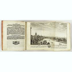
Neue und vollständige Topographie der Eidgnossschaft, in welcher die in den dreyzehen und zugewandten auch verbündeten Orten und Landen dermal befindliche Städte, Bischthümer, Stifte, Klöster, Schlösser, Amts-Häuser, Edelsitze und Burgställe...
The first edition of Herrliberger's work on the topography of Switzerland. - The rarest book on Switzerland rarely found complete.Illustrated with an engraved allegorical...
- $5500 / ≈ €4808
Date: Zurich, Johann Kaspar Ziegler, 1754-1773
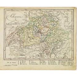
Nova Totius Helvetiae cum suis subditis ac sociis tab. Geogr. . .
Miniature map of Switzerland. Engraved by Tobias Conrad Lotter. Helvetia is the Roman name for an ancient region of central Europe occupying a plateau between the Alps an...
Date: Augsburg, J.M.Will, 1778
L'Elvezia divisa ne suoi Tredici Cantoni e suoi Alleati di nuova projezione.
Antonio Zatta's detailed map of the Confederation of Switzerland divided into its thirteen Cantons and their allies. Shows political and administrative boundaries, cities...
Date: Venice, 1781
Carte de la Suisses . . .
Scarce map of Switzerland prepared by de la Fosse and published by L.J. Mondhare for his Atlas Général a l'usage des colleges et maisons d'education.. Louis Joseph Mondha...
Date: Paris, 1783
Schweiz.
Nice small map of Switzerland by Johannes Walch in his rare Allgemeiner Atlas Nach den bewährsten Hülfsmitteln und astronomischen Ortsbestimungen…, edition of 1812.Johann...
Date: Augsburg, 1812
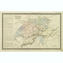
Confédération Suisse.
Finely engraved map of Switzerland prepared by A.H.Dufour and engraved by Giraldon-Bovinet. Published by Jules Renouard in his uncommon atlas "Le globe Atlas classiq...
Date: Paris, Jules Renouard, ca.1840
Suisse.
Detailed map of Switzerland, prepared by Charles V. Monin (fl.1830-1880) a French cartographer of Caen and Paris. Published in Atlas Universel de Géographie Ancienne &...
- $45 / ≈ €39
Date: Paris, 1845
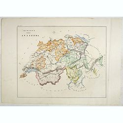
Karta öfver Helvetien.
An very rare map of Switzerland with Swedish text. This is an updated version of his map of 1820 and is now dated 1833.From his atlas "Geographisk Hand-Atlas" f...
Date: A. Wiborgs förlag, Stockholm, ca. 1848
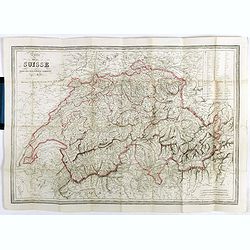
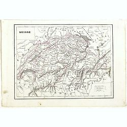
Carte de la Suisse . . .
Detailed canvas map of Switzerland.
Date: Paris, 1850
Diocesi della Svizzera (Tav IV)
This large-format Switzerland map is finely engraved and beautifully colored and was prepared by Girolamo Petri, a lawyer who served as a senior official within the Vatic...
- $750 / ≈ €656
Date: Rome, 1858
![[Voyage en Suisse / Reise die Schweiz.]](/uploads/cache/48396-250x250.jpg)
[Voyage en Suisse / Reise die Schweiz.]
A first edition children's folding board game of Switzerland and its many places and sights to visit. Although it is missing most of its original components (dice, cards,...
Date: Switzerland, 1891
