Browse Listings in Europe > Russia / Baltic / Black Sea region
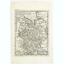
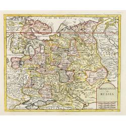
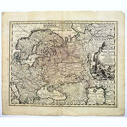
Russia or Moscovy with its Acquisitions &c.
Herman Moll's map of western Russia, or Muscovy, published in London during the first half of the eighteenth century. It shows the newly acquires lands taken from Sweden ...
- $200 / ≈ €187
Place & Date: London, 1729
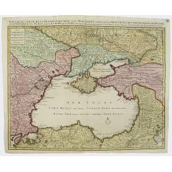
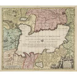
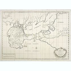
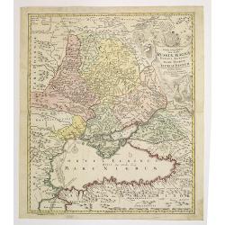
Nouvelle Carte de la Petite Tartarie et la Mer Noire, montrant les Frontieres de l'Impératrice de Russie et de l'Empereur des Turcs, tant en Europe qu'en Asie, Dessigné selon la proposition de G. De L'Isle et d'autres Auteurs.
The Ukraine and the Black Sea in a fine impression with original 18th-c. hand-coloring.
- $1250 / ≈ €1170
Place & Date: Amsterdam, 1730
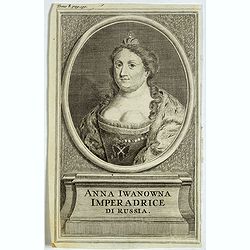
Anna Iwanowna Imperadrice di Russia.
Portrait of Anna Iwanowna (1693 – 1740), was regent of the duchy of Courland from 1711 until 1730 and then ruled as Empress of Russia from 1730 to 1740.
- $75 / ≈ €70
Place & Date: France, ca. 1730
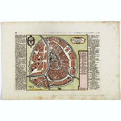
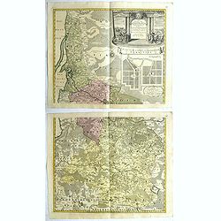
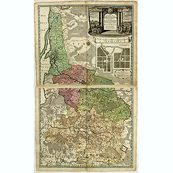
Moscow des Grossen Zaars Residenz.
A detailed plan of Moscow with an extensive description of the town and a numbered key 1-49 identifying important places. A coat of arms in the left corner.Afterwards, t...
- $400 / ≈ €374
Place & Date: Augsburg, 1730
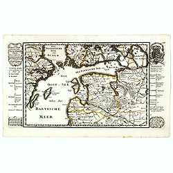
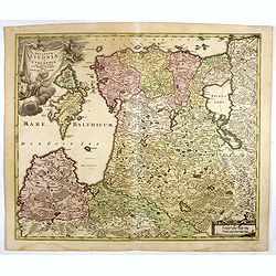
Der Nordischen Königreiche Süd=Oost Theil begreiffende Liefland Ingermanland und Finnland zum Theil.
Uncommon map published by Gabriel Bodenehr, who bought the Stridbeck copper plates in 1716, and continued publishing the Stridbeck Atlas: "Atlas Curieux," under...
- $400 / ≈ €374
Place & Date: Augsburg, 1730
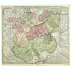
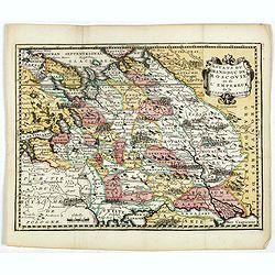
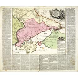
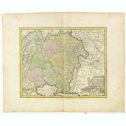
Imperii Moscovitici pars Australis.
A detailed map of the region around Moscow. Including the Ukraine and Cossack regions, to the west is Russian Poland and Lithuania, to the east Russian Tartary and Siberi...
- $500 / ≈ €468
Place & Date: Augsburg, 1730
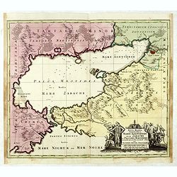
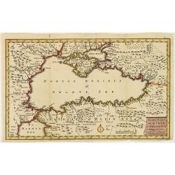
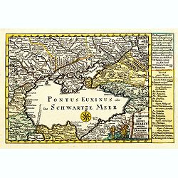
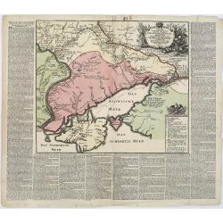
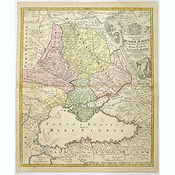
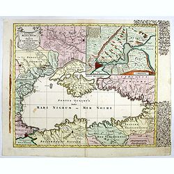
Nova Mappa Geographica Maris Assoviensis Vel De Zabache Et Paludis Maeotidis accurate aeri incis et in luce edita . . .
Striking map of the Sea of Azov with adjacent countries and the Strait of Kerch, with a decorative allegorical cartouche, showing the costumes of the indigenous people of...
- $400 / ≈ €374
Place & Date: Augsburg, 1730
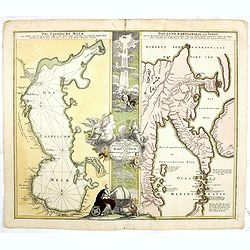
Geographica Nova ex Oriente gratiosissima, duabus tabulis specialissimis contenta, quarum una Mare Caspium..
Map of the Caspian Sea and the peninsula of Kamchatka (Jedso) in northeast Asia on one sheet.Separated by an attractive panel with figurative title cartouche, cherubs, an...
Place & Date: Nuremberg, 1730
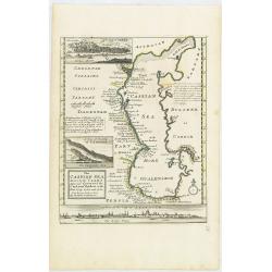
The Caspian Sea Drawn by the Czar's special command By Carl van Verden in the year 1719. 1720 and 1721. . .
Hand col. engraved map with 3 inset views. Includes geographical notes.With views of "Terky", "Derbent" and "Astracan"
Place & Date: London, 1732
Selling price: $375
Sold in 2011
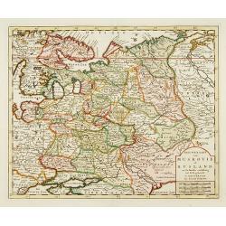
Nieuwe Kaart van Muskovie of Rusland..
Detailed map of European Russia, far south to the Black Sea and Caspian Sea. Isaac Tirion was born in Utrecht ca. 1705. He came to Amsterdam ca. 1725. Tirion published a ...
Place & Date: Amsterdam, 1734
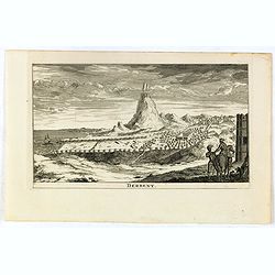
Derbent.
View of Derbent, the southernmost city in Russia from a scarce series of city views by Daniel de la Feuille (1640-1709). Engraving shows the ancient fortress and ruins of...
- $100 / ≈ €94
Place & Date: Amsterdam, 1734
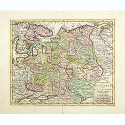
Nieuwe Kaart van Muskovie of Rusland.
Detailed map of European Russia, far south to the Black Sea and Caspian Sea. Isaac Tirion was born in Utrecht ca. 1705. He came to Amsterdam ca. 1725. Tirion published a ...
- $150 / ≈ €140
Place & Date: Amsterdam, 1734

Nova Maris Caspii et Regions Usbeck..
A detailed map of part of Russia, Central Asia centered on the Caspian, Uzbek territory to the east of the Caspian and northern Persia. A finely engraved, uncolored title...
Place & Date: Nuremberg, 1735
Potentissimo Borussorum Regi Friderico Wilhelmo Maiestate, Fortitudine Clementia Augustissimo Hancce Lithuaniam Borussicam : in qua luca coloniis Salisburg., ad incolendum Regio nutu concessa ...
Potentissimo Borussorum Regi Friderico Wilhelmo Maiestate, Fortitudine Clementia Augustissimo Hancce Lithuaniam Borussicam : in qua luca coloniis Salisburg., ad incolendu...
- $1200 / ≈ €1123
Place & Date: Nuremberg, 1735
Nieuwe kaart van de Crim de Zwarte Zee en omleggende. . .
Showing the Black Sea and the Marmara Sea with Istanbul. Published in the rare first edition of Kleyne en Beknopte Atlas, of Tooneel des Oorlogs in Europa...The atlas wa...
Place & Date: Amsterdam, 1735
Selling price: $450
Sold in 2013

Potentissimo Borussorum Regi Friderico Wilhelmo Maiestate, Fortitudine Clementia Augustissimo Hancce Lithuaniam Borussicam : in qua luca coloniis Salisburg., ad incolendum Regio nutu...
Potentissimo Borussorum Regi Friderico Wilhelmo Maiestate, Fortitudine Clementia Augustissimo Hancce Lithuaniam Borussicam : in qua luca coloniis Salisburg., ad incolendu...
Place & Date: Nuremberg, 1735
Potentissimo Borussorum Regi Friderico Wilhelmo Maiestate, Fortitudine Clementia Augustissimo Hancce Lithuaniam Borussicam : in qua luca coloniis Salisburg., ad incolendum Regio nutu concessa ...
Potentissimo Borussorum Regi Friderico Wilhelmo Maiestate, Fortitudine Clementia Augustissimo Hancce Lithuaniam Borussicam : in qua luca coloniis Salisburg., ad incolendu...
- $1500 / ≈ €1404
Place & Date: Nuremberg, 1735
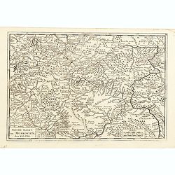
Nieuwe kaart van Muskovien door M. de l'Isle.
This lovely little map of the area surrounding Moscow is based on Delisle's map of the region. The map is bounded by Lake Ilmen in the north, the Volga River to the east,...
- $100 / ≈ €94
Place & Date: Amsterdam, 1735
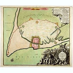
Ichnographia munitissimae Arcis Otzakoff quae Ao. 1737, die 3 Iulÿ auspicÿs Supremi Campi Mareschalli Comitis de Münnich ab exercitu Russorum vi occupata . . .
A striking image of this fortified Russian outpost on the Black Sea at Otzakoff, northeast of Odessa.
- $1250 / ≈ €1170
Place & Date: Augsburg, 1737
An exact map of the CRIM (Formely Taurica Chersonesus) Part of Lesser Tartary, the Sea of Asoph, and the adjacent Country of the Kuban Tartars. . .
Detailed and handsome wood block printed map centered on the Sea of Azov detailing the ongoing war between the Russians and Turks. The map is filled troop locations and b...
Place & Date: London, 1739
Selling price: $200
Sold in 2010
Nova et accuratissima Maris Caspii. . .
Original hand colored copper engraving of Matthaeus Seutter. Showing the Caspian Sea with the large Volga Delta in east orientation. Main towns / countries around the Cas...
- $1000 / ≈ €936
Place & Date: Augsburg, 1740
Moscovia o Russia.
Map showing European Russia and is centered on Moscow. In the lower right corner, title cartouche with scale and the town of Astrakhan. From "Atlante Novissimo Che C...
Place & Date: Venice, 1740
Moscoviae seu Russiae Magnae Generalis Tabula. . .
A scarce and attractive, wide-ranging map of incorporating Scandinavia, the Baltic countries, parts of Germany and Czechoslovakia, Poland, Hungary, Ukraine, Bulgaria, Nor...
- $1500 / ≈ €1404
Place & Date: Augsburg, 1740
Verus Chersonesi Tauricae Seu Crimea Conspectus adjacentium item Regionem itinerisq ab Exercitu Ruthemo Ao MDCCXXXVI et MDCCXXXVII adversus Tattaros Susceptis . . .
Map of the environs of the Crimea, showing the route of the Russian Army in its expedition against the Tartars in 1736 and 1737. Showing detailed movements, including enc...
Place & Date: St Petersburg, Academy of Sciences, 1740
Selling price: $700
Sold in 2015

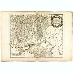
Carte particulière des environs de St Peters-bourg. . . / Plan de la ville faubourg et environs de St Petersbourg. . . / Carte pour l'intelligence de la guerre de Moscovie et de Suede. . .
A scarce and unusual plan of Saint Petersburg shown at a large scale and also, in a separate compartment, shown in its geographical context between the Gulf of Finland an...
Place & Date: Paris, c.1741
Die Europaeische oder kleine Tartarey, nebst den angraentzenden Laendern. . .
Showing the Black Sea region. Uncommon map from the "Atlas Selectus" by the German cartographer Johann Georg Schreiber (1676-1750). Schreiber followed in the fo...
- $450 / ≈ €421
Place & Date: Leipzig, 1741
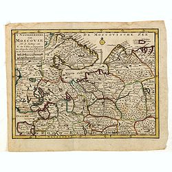
'T Noorderdeel van Moscovie Na de stelling van G. de L'Isle. . .
Attractive and rare map of part of Russia, including St. Persburg, Archangel, Finland, Lapland and Moscow. From Atlas Portatif .
- $100 / ≈ €94
Place & Date: Deventer, 1742

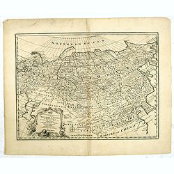
Imperii Russici et Tartariae Universae tabula novissima.
Decorative and rare map covering Russia, Tibet, China, Tartary, Korea, Taiwan and Japan prepared by J. M. Hasius. The sea between Japan and Korea is mentioned Mare Orient...
Place & Date: Utrecht, 1743

ANNA IWANOVNA - Anna Ioannovna imperatricea i camoderschiza wserossinskaja (rossice). Anna Joannowna imperatrix totius Russiae
Extremely rare half portrait print of Anna Ivanovna (7 February [O.S. 28 January] 1693, Moscow – 28 October [O.S. 17 October] 1740) reigned as Duchess of Courland from ...
Place & Date: St. Petersburg, 1743

ELISABETH I. - Elisabet imperatriza wseros sinskaja petra welikago dscherj (rossice). Elisabetha imperatrix. Omnium Russiarum Petri. Magni. Filia.
Extremely rare half portrait print of Elizaveta Petrovna (29 December [O.S. 18 December] 1709 – 5 January 1762 [O.S. 25 December 1761] ), also known as Yelisavet and El...
Place & Date: St. Petersburg, 1743

FJODOR JOANNOWITSCH - Feodor Ioannowitsch zar i camoderschez wserossinskij (rossice). Feodor Ioannowicz tzaar et autocrator totius Russiae Joann Alexiewicz tzaar et autocrator totius Russiae.
Extremely rare half portrait print of Czar Fyodor I Ivanovich (31 May 1557 – 16/17 January 1598) was the last Rurikid Tsar of Russia (1584 - 1598), son of Ivan the Terr...
Place & Date: St. Petersburg 1743

ALEXEI I. - Alexei Michailowitsch zar i camoderschez wserossinskij (rossice). Alexei Michailowicz tzaar et autocrator totius Russiae.
Extremely rare half portrait print of Czar Alexei Michailowicz..Aleksey Mikhailovich Romanov ( 9 March 1629 (O.S.) – 29 January 1676 was the Tsar of Russia during some ...
Place & Date: St. Petersburg, 1743

IWAN ALEXEJEWITSCH - Ioann Alexejewitsch zar i camoderschez wserossinskij (rossice).Joann Alexiewicz tzaar et autocrator totius Russiae.
Extremely rare print of Czar Ivan Alexejewitsch, who was the brother of Peter the Great.Johann Stenglin was a well known engraver, born at Augsburg in 1715, he studied un...
Place & Date: St. Petersburg 1743
![[2 maps and one text sheet] Theatrum Belli A° MDCCXXXVII. . . / Verus Chersonesi Tauricae Seu Crimea Conspectus adjacentium item Regionem itinerisq ab Exercitu Ruthemo...](/uploads/cache/27975-250x250.jpg)
[2 maps and one text sheet] Theatrum Belli A° MDCCXXXVII. . . / Verus Chersonesi Tauricae Seu Crimea Conspectus adjacentium item Regionem itinerisq ab Exercitu Ruthemo...
[2 maps and one text sheet] Theatrum Belli A° MDCCXXXVII. . . / Verus Chersonesi Tauricae Seu Crimea Conspectus adjacentium item Regionem itinerisq ab Exercitu Ruthemo A...
- $1100 / ≈ €1029
Place & Date: Amsterdam, c. 1744
![ATLAS RUSSICUS mappa una generali et undeviginti specialibus vastissimum Imperium Russicum cum adiacentibus regionibus [repeated in French].](/uploads/cache/27877-250x250.jpg)
ATLAS RUSSICUS mappa una generali et undeviginti specialibus vastissimum Imperium Russicum cum adiacentibus regionibus [repeated in French].
After an unnumbered general map of Russia there are 13 numbered maps that cover European Russia (scale 1, 1.527.000). The other (last) 6 maps cover Asian Russia (Siberia,...
Place & Date: St Peterburg, Akademie von Wissenschaften. 1745
A New and Accurate Map of the Whole Russian Empire as contained both in Europe and Asia. . .
Detailed map of Russia, from the Sea of Anadyr, Sea of Kamchatka and the Kuril Islands to St.Petersburg. Also includes Tibet, Korea and part of China, with the Great Wall...
- $200 / ≈ €187
Place & Date: London, c. 1747
Carte de L'Asie Mineure ou de la Natolie et du Pont Euxin
Johann Baptist Homann's well-engraved map of Asia Minor, the Black Sea ( Ponti Euxin), Crimea and a part of Greece. Depicts Turkey and the area surrounding the Black Sea ...
- $500 / ≈ €468
Place & Date: Nuremberg, ca. 1748
Estats du Grand duc de Moscovie ou de l'Empereur de la Russie Blanche.
Uncommon map of European Russia centered on Muscovy. Charming title cartouche in upper right corner.
- $300 / ≈ €281
Place & Date: Amsterdam, ca 1749
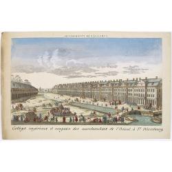
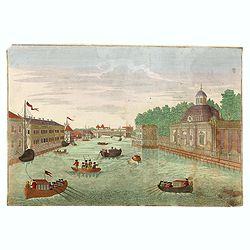
Colléges impériaux et magasin des marchandises de l'Orient, à St. Pétersbourg.
Showing a busy scene at the international trading grounds of 18th century Saint Petersburg, showing the warehouses of the different international trading companies. J. Ch...
- $200 / ≈ €187
Place & Date: Paris, ca. 1750
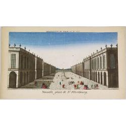
Nouvelle place de St. Pétersbourg.
Showing a square at 18th century Saint Petersburg. J. Chereau was a publisher of optical prints, established in Paris, rue St.Jacques.In the eighteenth and nineteenth ce...
- $200 / ≈ €187
Place & Date: Paris, ca. 1750
Charte der Kriegs Operationen am Donn u: Dnieper Ihro Russisch Kayserl Majestaet Glorieusen Armeen A: 1736
Scarce separately published map of the southern part of Ukraine, with an explanatory key A-N in the lower right. The map is surrounded by letterpress German text giving a...
Place & Date: Augsburg, 1750
Selling price: $900
Sold in 2011
Charte der Kriegs Operationen am Donn u: Dnieper Ihro Russisch Kayserl Majestaet Glorieusen Armeen A: 1736.
Very rare separately published map of the southern part of Ukraine, with an explanatory key A-N in the lower right. The map is surrounded by letterpress German text givin...
- $900 / ≈ €842
Place & Date: Augsburg, 1750
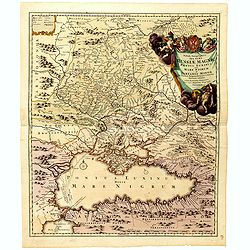
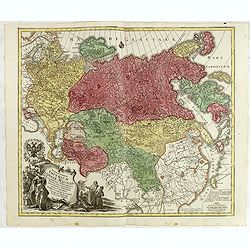
Tabula Geographica qua pars Russiae Magnae. . .
Homann's map is based upon the works of George von Mengden (1628-1702), a Livonian cartographer who worked for Peter the Great and Count Jacob Bruce [Graf Jakov Villimovi...
- $600 / ≈ €561
Place & Date: Nuremburg, after 1750
Imperium Moscoviae.
Map of the empire of Moscovia
- $300 / ≈ €281
Place & Date: Nuremberg, 1750
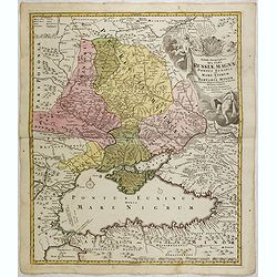
Tabula Geographica qua pars Russiae Magnae Pontus Euxinus seu Mare Nigrum et Tartaria Minor.
Homann's map is based upon the works of George von Mengden (1628-1702) a Livonian cartographer who worked for Peter the Great and Count Jacob Bruce [Graf Jakov Villimovic...
- $750 / ≈ €702
Place & Date: Nuremburg, after 1750
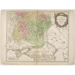
Tabula Geographica qua pars Russiae Magnae Pontus Euxinus seu mare Nigrum et Tartaria Minor cum finitimis Bulgariae, et Romaniae et Natoliae. . .
Homann's map is based upon Beauplan's general map of Ukraine but depicts the political changes of the preceding years. Shows Constantinople. Extends north to Moscow and S...
- $700 / ≈ €655
Place & Date: Nuremburg, 1750
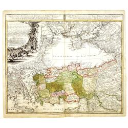
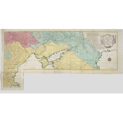
Partie Méridionale de la Russie Européenne. . .
Detailed map of Ukraine, the Crimea and the northern part of the Caspian Sea.
- $650 / ≈ €608
Place & Date: Paris, 1752
Partie méridionale de la Russie Européenne. . .
Detailed map of Ukraine and the Crimea. In lower right corner inset map of Cosaques. From his "Atlas Universel".Gilles Robert de Vaugondy (1688–1766), also kn...
Place & Date: Paris, 1752
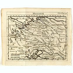
Moscovie.
Scarce small map centered on Muscovy and based on cartography of Guillaume Delisle (. Published in "Nouveau traité de geographie par M**** ", published by La v...
- $50 / ≈ €47
Place & Date: Paris, 1752
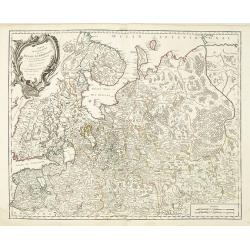
Partie Septentrionale de la Russie Européenne . . .
Detailed map of European part of Russia, including Finland, Lapland.
Place & Date: Paris, 1753

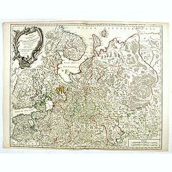
Russie Européenne . . .
Detailed map of European part of Russia, including Finland and Lapland.Gilles Robert de Vaugondy (1688–1766), also known as Le Sieur or Monsieur Robert, and his son, Di...
Place & Date: Paris, ca. 1753
Partie Septentrionale de la Russie Européenne . . .
Detailed map of European part of Russia, including Finland, Lapland.
- $100 / ≈ €94
Place & Date: Paris, 1753
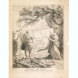
Britannia And Persia.
A finely engraved and unusual depiction of Britannia and Persia, two women with spears and shields holding a map between them. This map depicts a route through the Baltic...
- $800 / ≈ €749
Place & Date: London, 1753
Essai D'Une Nouvelle Carte de la Mer Caspienne.
Interesting map of the Caspian Sea between Russia and Iran. Jean Baptiste d'Anville (1697-1782) born in Paris was perhaps the most important and prolific cartographer of ...
- $80 / ≈ €75
Place & Date: Paris, 1754
Spatiosissimum Imperium Russiae Magnae juxta recentissimas Observationes Mappa Geographica . . .
Decorative map of greater Russia, extending from Livonia in the west to Kamchatka, China, Tibet, Taiwan, Korea and part of Japan in the east. To the south, it runs from G...
- $750 / ≈ €702
Place & Date: Augsburg, 1757
![[Lot of 8 maps of European Russia] Partie Septentrionale de la Russie Europeenne ou sont distinguees exactement toutes les Provinces](/uploads/cache/18563-(3)-250x250.jpg)
[Lot of 8 maps of European Russia] Partie Septentrionale de la Russie Europeenne ou sont distinguees exactement toutes les Provinces
[Lot of 8 maps of European Russia]- Partie Septentrionale de la Russie Européenne òu sont distinguées exactement toutes les Provinces (1753)- Carte des Pais Habites p...
- $850 / ≈ €795
Place & Date: Atlas Universel PARIS 1757
Spatiosissimum Imperium Russiae Magnae juxta recentissimas Observationes Mappa Geographica . . .
Decorative map of greater Russia, extending from Livonia in the west to Kamchatka, China, Tibet, Taiwan and part of Japan in the east. To the south it runs from Georgia (...
- $700 / ≈ €655
Place & Date: Augsburg, 1757
Theatrum belli Russorum Victoriis illustratum sive Nova et accurata Turcicarum et Tartaricum. . .
Uncommon and decorative map of Ukraine, showing the theatre of the Russo-Turkish War in the Ukraine in 1735-1739. The map gives detailed information of the fortifications...
- $1250 / ≈ €1170
Place & Date: Nuremberg, ca. 1757
Mappa Geographica Regni Poloniae ex novissimis quotquot sunt mappis specialibus composita et al L.L. Stereographicae projectionis revocata a Tob. Mayero. . . .
Decorative map of Poland after Tobias Mayer who was based on Barnikel's map of Curland (1747) and Jan Nieprzecki's map of Lithuania (1749).Poland extends from Glogau and ...
- $600 / ≈ €561
Place & Date: Nuremberg, 1757
Partie De La Mer Glaciale Contenant La Nouvelle Zemble et Le Pais Des Samoiedes . . . 1758
Detailed map of Nova Zembla and part of the Northeast passage.From Prevost's l'Histoire générale des voyages , the map prepared by J.N. Bellin. Jacques Nicolas Bellin (...
- $50 / ≈ €47
Place & Date: Paris, 1758
Partie de la Mer Glaciale contenant de la nouvelle Zemble..
A good engraved map of Nova Zembla. The geographical features are typical with somewhat exaggerated bays and inlets. From l'Histoire générale des voyages .
- $80 / ≈ €75
Place & Date: Paris, 1758
Partie De La Mer Glaciale Contenant La Nouvelle Zemble et Le Pais Des Samoiedes . . . 1758
Detailed map of Nova Zembla and part of the Northeast passage.From Prevost's l'Histoire générale des voyages , the map prepared by J.N. Bellin. Jacques Nicolas Bellin (...
- $60 / ≈ €56
Place & Date: Paris, 1758
Carte du Detroit de Waigats ou de Nassau. . . 1758. N°.2.
Showing the Dutch voyage of 1594 which proved Nova Zemlya was an island separated from the continent by the "le Waigats Detroit". Several sounding shown.From Pr...
- $40 / ≈ €37
Place & Date: Paris, 1758
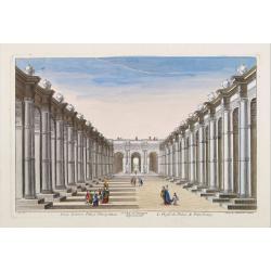
15e. Vüe d'Optique Representant Le Profil du Palais de Petersbourg.
So-called optical print illustrating a perspective view of the portico of a Palace in Saint Petersburg. Published by Daumont, a well-known publisher of optical prints, es...
- $250 / ≈ €234
Place & Date: Paris, 1760

Vuë de l'ancien Palais d'hiver de sa Majesté Imperiale et du Canal qui Joint la Moika avec la Neva, a St. Petersburg.
So-called optical print illustrating a perspective view of St. Petersburg, namely the ancient Winter Palace and the canal which joins the Moika to the Neva.In the eightee...
Place & Date: Paris, 1760
Nova Mappa Maris Nigri et Freti Constantino Politani. . .
Decorative and uncommon map the Black Sea region. In upper left hand corner an inset map (200 x 280mm) of the Bosporus including Istanbul. Title engraved onto a drape-sty...
- $450 / ≈ €421
Place & Date: Augsburg, ca. 1760
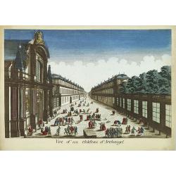
Vue d'un château d'Archangel.
So-called optical print of a street and house in Arkhangelsk, by the well-known publisher of optical prints, Basset, established in rue St.Jacques in Paris. In the eighte...
- $300 / ≈ €281
Place & Date: Paris, 1760
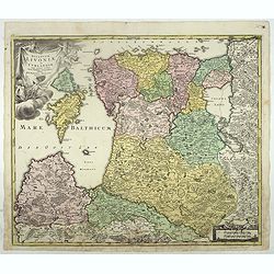
Dvcatvvm Livoniae et Cvrlandiae cum vicinis insulis nova exhibitio geographica.
A very attractive of Livonia, Estonia, Curlandia and the Baltic coast, which also includes the Gulf of Livonia or Riga.
- $450 / ≈ €421
Place & Date: Nuremberg, 1760
Carte géographique représentant le théâtre de la guerre entre les Russes, les Turcs et les Polonois confédérés. . .
Interesting and rare map showing the area of the Russo-Turkish Wars. To the right a large title cartouche and extensive text describing the different stages and the Wars ...
- $1500 / ≈ €1404
Place & Date: Augsburg, 1760
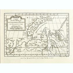
Carte des Païs habités par les Samojedes et Ostiacs, pour l'histoire générale des voyages.
Map shows Nova Zembla and the area of northern Russia that was inhabited by the Samoyeds and Ostiacs.Prepared by Jacques Nicolas Bellin after Dutch sources and included i...
- $75 / ≈ €70
Place & Date: Paris, 1760
Dvcatvvm Livoniae et Cvrlandiae cum vicinis insulis nova exhibitio geographica.
A very attractive of Livonia, Estonia, Curlandia and the Baltic coast, which also includes the Gulf of Livonia or Riga.
- $500 / ≈ €468
Place & Date: Nuremberg, 1760
Nova Mappa Maris Nigris et Freti Constantinopolitani...
Map of the Black Sea with the Crimea and adjacent countries, inset map of the Bosporus with Constantinople at upper right.T.C. Lotter married M. Seutter's daughter in 174...
- $600 / ≈ €561
Place & Date: Augsburg, ca. 1760

Vue de la superbe Gallerie de Petersbourg en Russie.
So-called optical print illustrates a perspective view of the interior of a palace in Saint Petersburg.Mondhare was a well-known publisher of optical prints, established ...
- $200 / ≈ €187
Place & Date: Paris, 1761
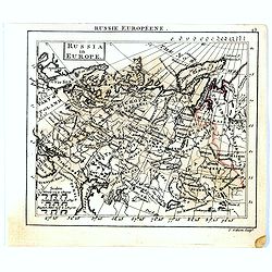
Russia in Europe.
Uncommon miniature map of Russia, engraved by Thomas Kitching for "A New General and Universal Atlas Containing Forty five Maps by Andrew Dury".This miniature a...
- $75 / ≈ €70
Place & Date: London, 1761-1763
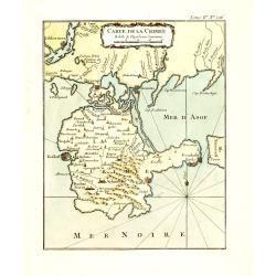
Carte de la Crimée.
Fine map of Crimea (Ukraine) here in the only issue of this version of Bellin's map, slightly larger than the common version. From Bellin's Le Petit Atlas Maritime Recuei...
- $175 / ≈ €164
Place & Date: Paris, 1764

Ajustement des Femmes de Valday Situé entre Petersbourg et Moscou.
Etching by Jean-Baptiste Le Prince (1734-1781), from "2me Suite de divers cris de marchands de Russie", showing typical russian customs. The sketches Le Prince ...
- $110 / ≈ €103
Place & Date: Paris, 1764
![[MANUSCRIPT] Carte nouvelle de la Crimée et des pays circonvoisins.](/uploads/cache/30484-250x250.jpg)
[MANUSCRIPT] Carte nouvelle de la Crimée et des pays circonvoisins.
A beautiful manuscript map on paper. Showing the northern part of the Black Sea region with Crimea.Interesting are the border lines of "New Serbia", shown in th...
Place & Date: ca. 1752-1764

Nouveau théâtre de la guerre entre les Russes les turcs et les polonois confédérés.
A very rare separately published map of Crime region. With a large title cartouche lower left "Nouveau theâtre de la guerre entre les russes, les turcs et les polon...
- $2000 / ≈ €1871
Place & Date: Paris, 1769
(Hof, Voraths-Magazin, am Fontanka Flus, Zu Petersburg.)
So-called optical print illustrating a perspective view of the river Fontanka in Saint Petersburg. The Fontanka is a branch of the Neva river. At the right of the print w...
- $225 / ≈ €211
Place & Date: Augsburg, c.1770
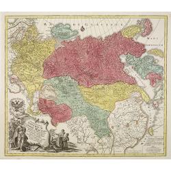
Tabula Geographica qua pars Russiae Magnae. . .
U unrecorded state Homann's map is based upon the works of George von Mengden (1628-1702), a Livonian cartographer who worked for Peter the Great and Count Jacob Bruce [G...
- $1000 / ≈ €936
Place & Date: Nuremberg, c. 1770