Browse Listings in Europe > Russia / Baltic / Black Sea region

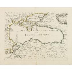
Black Sea.
Decorative steel engraved map of the Black Sea with inset views of Sebastopol and Odessa. There are also vignettes of Constantinople, Sinope and Varna. Taken from "T...
- $90 / ≈ €84
Place & Date: London, London Printing and publishing Company of London, ca. 1851
![[Pictorial map of Georgia (Caucasus)].](/uploads/cache/44292-250x250.jpg)
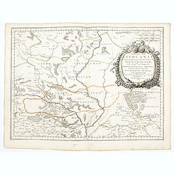
[Pictorial map of Georgia (Caucasus)].
A scarce pictorial map of a region in Georgia in the Caucasus. Map is entirely in Russian, complete with legend at base of map, with small thumbnail pictures and symbols ...
- $150 / ≈ €140
Place & Date: Moscow, 1963
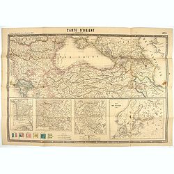
Carte d'Orient par Kraminski ingénieur.
Large map of Orient, with an insert of four maps (Constantinople plan - Map of Europe - Map of Russia - Plan of Baltic sea). With flags in the lower left part. color key ...
Place & Date: Paris, 1854
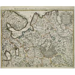
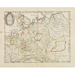
Russiae, Moscoviae et Tartariae Descriptio.
Engraved by Frans Hogenberg from an original of 1562 by Anthony Jenkinson of the English Muscovy Company. The many vignettes are based on the reports of Marco Polo's expl...
Place & Date: Antwerp, 1598
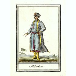
Kabardinien.
Originally hand-colored costume mezzotint of a Kabardian from the Northwest Caucasus, engraved by Félix Mixelle and Lachaussée Jeune after Jacques Grasset de Saint-Sauv...
Place & Date: Paris,1801-1806
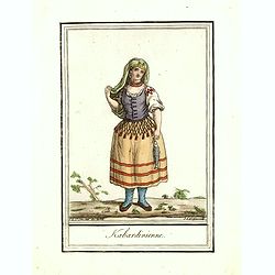
Kabardinienne.
Originally hand-colored costume mezzotint of a Kabardian woman from the Northwest Caucasus, engraved by Félix Mixelle and Lachaussée Jeune after Jacques Grasset de Sain...
Place & Date: Paris,1801-1806
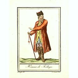
Homme de Kaluga.
Originally hand-colored costume mezzotint of a man from Kaluga engraved by Félix Mixelle and Lachaussée Jeune after Jacques Grasset de Saint-Sauveur.As an etcher, drawe...
Place & Date: Paris,1801-1806
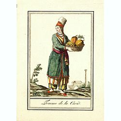
Femme de la Carie.
Originally hand-colored mezzotint costume plate of a woman from the Republic of Karelia, engraved by Félix Mixelle and Lachaussée Jeune after Jacques Grasset de Saint-S...
Place & Date: Paris,1801-1806
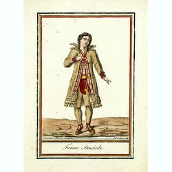
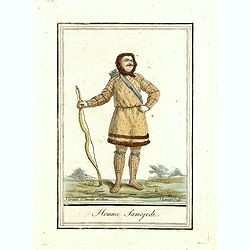
Femme Samoïede.
Originally hand-colored mezzotint of a Samoïede woman engraved by Félix Mixelle and Lachaussée Jeune after Jacques Grasset de Saint-Sauveur.As an etcher, drawer and wr...
Place & Date: Paris,1801-1806
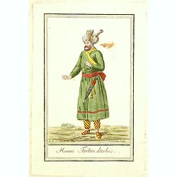
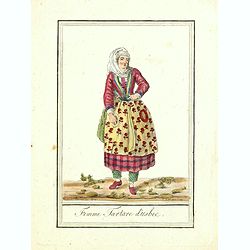
Homme Tartare d'Usbec.
Originally hand-colored costume mezzotint of a man from Uzbekistan engraved by Félix Mixelle and Lachaussée Jeune after Jacques Grasset de Saint-Sauveur.As an etcher, d...
Place & Date: Paris,1801-1806
Femme Tartare d'Usbec.
Originally hand-colored costume mezzotint of a woman from Uzbekistan engraved by Félix Mixelle and Lachaussée Jeune after Jacques Grasset de Saint-Sauveur.As an etcher,...
Place & Date: Paris,1801-1806
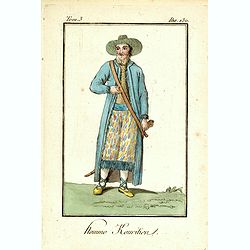
Homme Kouritien.
Originally hand-colored mezzotint of a Siberian man dressed in native garb, engraved by Félix Mixelle and Lachaussée Jeune after Jacques Grasset de Saint-Sauveur.As an ...
Place & Date: Paris,1801-1806
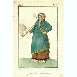
Femme de Barabinze.
Originally hand-colored mezzotint of a woman from Barabinze, engraved by Félix Mixelle and Lachaussée Jeune after Jacques Grasset de Saint-Sauveur.As an etcher, drawer ...
Place & Date: Paris,1801-1806
Kriegstheater oder Graenzkarte Oesterreichs, Russlands, und der Türkey. . .
Map of the theatre of war in the Balkans, Ukraine and around the Black Sea, indicating the Austrian, Russian and Turkish spheres of influence. Printed on two sheets and j...
Place & Date: Artaria und Compagnie, Vienna, 1788
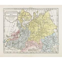
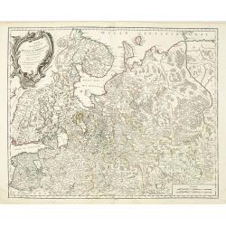
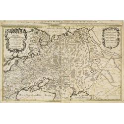
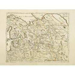
Partie Septentrionale de la Russie Européenne . . .
Detailed map of European part of Russia, including Finland and Lapland.
Place & Date: Paris, 1780
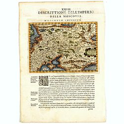
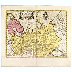
Descrittione Dell'Imperio della MOSCOVIA IMPERIUM.
Uncommon map including Latvia, Livonia, Lithuania, the Ukraine, and northern Part of the Black Sea and the Caspian Sea, Siberia, Georgia, Azerbaijan, Kazakhstan.Giovanni ...
Place & Date: Venice, 1596
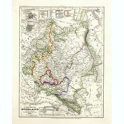
Das Europäische Russland nebst den asiatischen Provinzen diesseit des Ural. 1849.
Detailed map of Russia, with inset plans of St. Petersburg and Moscow with extensive key to the different provinces. The map was according to a text revised in 1856.From ...
Place & Date: Hildburghausen / Philadelphia 1856
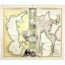
Geographica Nova ex Oriente gratiosissima, duabus tabulis specialissimis contenta, quarum una Mare Caspium..
Map of the Caspian Sea and the peninsula of Kamchatka (Jedso) in northeast Asia on one sheet.Separated by an attractive panel with figurative title cartouche, cherubs, an...
Place & Date: Nuremberg, 1730
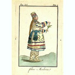
Femme Mordivine.
Originally hand-colored mezzotint of a Mordvinian woman from Ural region dressed in native garb, engraved by Félix Mixelle and Lachaussée Jeune after Jacques Grasset de...
Place & Date: Paris,1801-1806
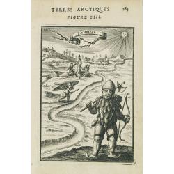
Zemblien.
Engraving presenting inhabitants of Nova Zembla from his monumental work "Description de L'Univers."
Place & Date: Paris, 1685
Il governo di arcangelo nell' impero della russia diviso. . .
Detailed map of the northern part of the Russian Empire with a decorative title cartouche. In the upper left corner part of the Baltic Sea with Lapland. Published in the ...
Place & Date: Rome, 1795-1796
Carte générale de l'empire de Russie.
Map of Russia. Map from a second French edition of Peter Simon Pallas' Voyages du Professeur Pallas, dans Plusieurs Provinces de l’Empire de Russie et dans l’Asie Sep...
Place & Date: Paris, Maradan, 1794
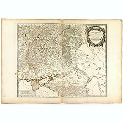
Partie méridionale de la Russie Européenne. . .
Detailed map of Ukraine and the Crimea. In lower right corner inset map of Cosaques. From his "Atlas Universel".Gilles Robert de Vaugondy (1688–1766), also kn...
Place & Date: Paris, 1752
Plan et coupe horisontale du labyrinte souterrain de Koungour Renvoi.
Engraved map of the Urals with the town Kungur in Russia. With a lettered key A-P in left corner. From the Atlas Volume of "Histoire physique, morale, civile et poli...
Place & Date: Paris, 1783
Russiae vulgo Moscovia dictae, Partes Septentrionalis. . .
In the north the Murmansk Sea. Including the western coast of Nova Zembla. Title cartouche and two cartouches, the bottom right one showing two hunters, bears, stags etc....
Place & Date: Amsterdam, 1720
Moscovia o Russia.
Map showing European Russia and is centered on Moscow. In the lower right corner, title cartouche with scale and the town of Astrakhan. From "Atlante Novissimo Che C...
Place & Date: Venice, 1740
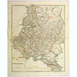
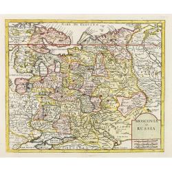
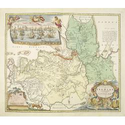
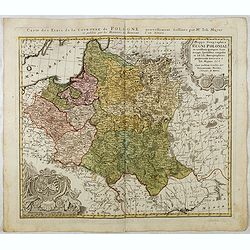
Russia & Poland.
A glorious, large steel engraved map of Russia and Poland. Covering Poland and Finland in the west, as far south as to the very edges of Persia, the Black sea, and to the...
Place & Date: London, 1839
Homme Samojede.
Originally hand-colored mezzotint costume plate of a man from Samojede engraved by Félix Mixelle and Lachaussée Jeune after Jacques Grasset de Saint-Sauveur.As an etche...
Place & Date: Paris,1801-1806
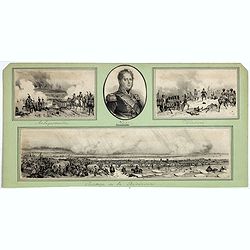
Passage de la Berezinas.
Set of four views of The Battle of Berezina (or Beresina) which took place from 26 to 29 November 1812, between the French army of Napoleon, retreating after his invasion...
Place & Date: ca. 1812
![[Costumes des Karabulaks - Caucase]](/uploads/cache/62344-250x250.jpg)
[Costumes des Karabulaks - Caucase]
Four men from the Caucasus in typical dress from the Karabulaks tribe. Plate N° 15. from Giulio Ferrario's work "Le Costume Ancien et Moderne ou Histoire du gouvern...
Place & Date: Milan, 1827
![[Costume plate of Grebenski Cossacks in the Caucasus]](/uploads/cache/62339-250x250.jpg)
[Costume plate of Grebenski Cossacks in the Caucasus]
Aquatint costume plate of Grebenski Cossacks in the Caucasus. Plate N° 10. From Giulio Ferrario's work Le Costume ancien et moderne ou histoire du gouvernement, de la mi...
Place & Date: Milan, 1827
Partie Septentrionale de la Russie Européenne . . .
Detailed map of European part of Russia, including Finland, Lapland.
Place & Date: Paris, 1753
Taurica Chersonesus, Nostra aetate Przecopsca, et Gazara dicitur.
Part of Russia with in the north Smolensk and Moscow and in the south the Black Sea.As Willem Blaeu died in 1638 most of his maps are actually published by his son Joan. ...
Place & Date: Amsterdam, 1638
Ingermanlandiae seu Ingriae novissima tabula luci tradita. . .
Detailed map centered on Saint Petersburg. With imposing title cartouche and panoramic view of Saint Petersburg. The map was drawn shortly after the conclusion of the Gre...
Place & Date: Nurenberg, 1780
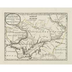
Des Russischen Reiches Statthalterschaften Neurussland, Asow, und das Oestliche Nogay
Map showing Lake Asow and the Crimea. The river Dnepr until Krementschug, and the river Don until Pawlowsk. Published by Franz Johann Joseph von Reilly.
Place & Date: Vienna, 1789
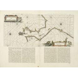
Fretum Nassovium vulgo de Straet Nassou.
Decorative map of the Nassau Strait, from the Atlas Major. Includes 2 compass roses, sailing ships, rhumb lines and 2 elaborate cartouches. Latin text below and on verso....
Place & Date: Amsterdam, 1662
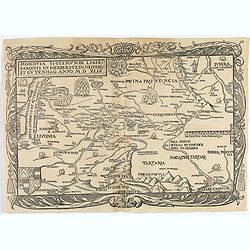
Moscovia Sigismundi Liberi Baronis In Herberstein, Neiperg et Gutehnag Anno M.D XLIX
First Modern Map of Russia. A rare and important cornerstone map for any Russian collection.One of two maps of Russia compiled by Herberstein, who was ambassador from the...
Place & Date: Basle, 1556
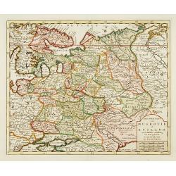
Nieuwe Kaart van Muskovie of Rusland..
Detailed map of European Russia, far south to the Black Sea and Caspian Sea. Isaac Tirion was born in Utrecht ca. 1705. He came to Amsterdam ca. 1725. Tirion published a ...
Place & Date: Amsterdam, 1734
Maris Assoviensis vel de Zabache et Paludis Maeotidis. . .
A very detailed map showing the Black Sea, Azow and Rostow area.
Place & Date: Augsburg, 1720
Russiae, Moscoviae et Tartariae Descriptio.
Engraved by Frans Hogenberg from an original of 1562 by Anthony Jenkinson of the English Muscovy Company. The many vignettes are based on the reports of Marco Polo's expl...
Place & Date: Antwerp, 1598
Carte de Moscovie. . .
Centred on Moscow, including Lapland. With fine uncolored title cartouche.
Place & Date: Amsterdam, 1720
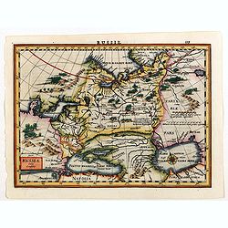
Russia.
Russia map from the rare Cloppenburg edition slightly larger format and more scarce edition of the Mercator/Hondius "Atlas Minor". Engraved by Pieter Van Den Ke...
Place & Date: Amsterdam, 1630
La Russie blanche ou moscovie. . .
Fine map of the European part of Russia with a decorative title and scale cartouche.Alexis-Hubert Jaillot (1632-1712), was a French cartographer. He joined the Sanson hei...
Place & Date: Amsterdam, 1692
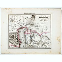
Il Turkestan il Mar d'Aral ed il Mar Caspio.
Uncommon map of Turkestan with the Northern part of the Caspian Sea, prepared by Francesco Costantino Marmocchi. Above the map "Geografia Commerciale". From &qu...
Place & Date: Genova, Paolo Rivara fu Giacomo, 1858
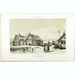
Village de Goumnisthe entre Kostroma et Yaroslaw..
A view of Goumnisthe village. Figures are lithographed by Raffet. Plate taken from the first illustrated account of Russian architecture. This publication was the project...
Place & Date: Paris, 1844
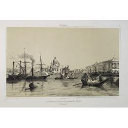
Cathédrale d'Isaac et Palais du Sénat. Vue prise de la Néva. (17 juillet 1839).
A view from the port of the Isaac Cathedral and the Senat Palace in Saint Petersburg on July 17 1839. Plate taken from the first illustrated account of Russian architectu...
Place & Date: Paris, 1845
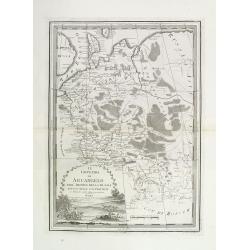
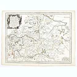
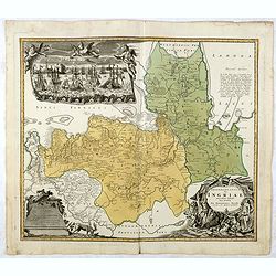
Partie de Lithuanie ou est en partie le Palatinat de Nowogrodeck Litawiski, subdivisé en leurs Chastellenies , le Palatinat de Bressici en Polesie, avec les duchés de Neswies, et Slusck, et partie du Palatinat de Minsk.
Scarce regional map, centered on Pinsk and showing Polish Lithuania, including part of modern Poland, Belarus, etc. This edition carries the date 1665. Nicolas Sanson was...
Place & Date: Paris, 1665
Partie de Lithuanie ou sont en partie les Palatinats de Wilna, et Troki, subdivisés en leurs Chastellenies et partie du Palatinat de Minsk.
Fine map of Lithuania. This edition carries the date 1665 and the publishers address "A Paris, chez Pierre Mariette, rue Saint Jacques a l'Esperance…"Nicolas ...
Place & Date: Paris, 1666
Russie Blanche ou Moscovie.
Map of the European part of Russia prepared by N.Sanson and published by Pierre Mariette.Published in an early edition of the small Sanson atlas L'Europe Dediée a Monsei...
Place & Date: Paris, P. Mariette, 1667
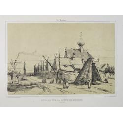
Village sur la route de Moscou. (9 Août 1839).
A view of a village on the way to Saint Petersburg on August 9 1839. Plate taken from the first illustrated account of Russian architecture. This publication was the proj...
Place & Date: Paris, 1842
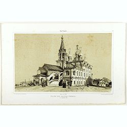
Eglise des saintes femmes.
A view of a church, the 5 of September 1839. Figures are lithographed by Raffet. Plate taken from the first illustrated account of Russian architecture. This publication ...
Place & Date: Paris, 1844
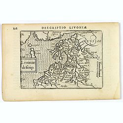
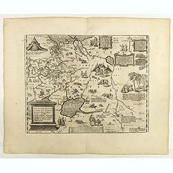
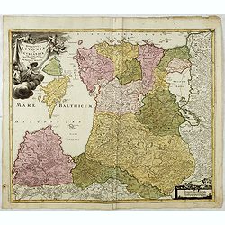
Livoniae descrip.
An attractive miniature map of the Baltic region of Livonia, as it was at the beginning of the seventeenth century, and published by Petrus Bertius in Amsterdam. The map ...
Place & Date: Amsterdam, 1606
Mer Noire ou Mer Maievre, . . .
Map of the Black Sea prepared by N.Sanson and published by Pierre Mariette.Published in an early edition of the small Sanson atlas L'Europe Dediée a Monseigneur . . . Le...
Place & Date: Paris, P. Mariette, 1667
Palais de Paul 1er. Côté du Jardin d'Eté. (16 Juillet 1839).
A view of Paul the First Palace in Saint Petersburg on August 9 1839. Figures are lithographed by Raffet. Plate taken from the first illustrated account of Russian archit...
Place & Date: Paris, 1844
Partie de Lithuanie ou sont en partie les Palatinats de Minsk, et Mseislaw, we les Seign.Ries ou Terres de Rohaczow, Rzeczica, Zernobee, et partie des. . .
Fine map of Lithuania. This edition carries the publishers address "chez l'Autheur Avec privilege pour vingt ans 1666". Nicolas Sanson was to bring about the ri...
Place & Date: Paris, 1666
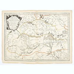
Partie de Lithuanie où sont les palatinats de Poloczk, Witepsk, Mseislaw, et partie de Minsk avec le duché de Smolensko.
Scarce and fine map of Belarus, including Smolensko in Russia and the region northeast of Minsk. This edition carries the date 1665 and the publishers address "A Par...
Place & Date: Paris, 1665
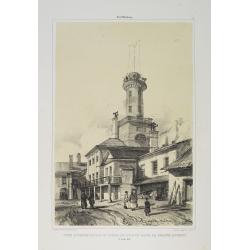
Tour d'Observation et siège de police dans la grande Morskoi. (2 Juillet 1839).
A view of Observation Tower and police headquarters in the Morskoi in Saint Petersburg on August 9 1839. Plate taken from the first illustrated account of Russian archite...
Place & Date: Paris, 1840
Selling price: $250
Sold in 2013
La Livonie duché divisée en ses princip. parties Esten & Letten & c. / par le Sr. Sanson. . .
Fine map of the Baltic Coast from Riga to the Gulf of Finland, with the islands of Saaramaa and Hiiumaa off the coast of Estonia. Title cartouche in lower left corner and...
Place & Date: Paris, 1663
![[Nova Zembla]](/uploads/cache/44870-250x250.jpg)
[Nova Zembla]
Charming and decorative miniature map of the Russian island of Nowaya Zemlya. With the depiction of Barentsz.' route. With inset with 2 birds ("Loms Vögel oder Nort...
Place & Date: Frankfurt am Main, 1604
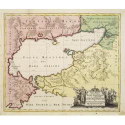
Nova Mappa Geographica Maris Assoviensis Vel De Zabache Et Paludis Maeotidis accurate aeri incis et in luce edita . . .
Striking map of the Sea of Azov with adjacent countries and the Strait of Kerch, with a decorative allegorical cartouche, showing the costumes of the indigenous people of...
- $400 / ≈ €374
Place & Date: Augsburg, 1730
Regnum Borussiae gloriosis auspicijs Seerenissimi et Potentissimi Princip Friderici III Primi . . .
Map covering the region along the Baltic Sea from Prussia, Memel, to northern Poland, extending south to Poland, centered on Danzig, Konigsberg, Heilsperg, etc. Beautiful...
- $350 / ≈ €328
Place & Date: Nuremberg, 1720
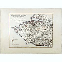
Accampamenti, Trinceramenti, ed Operazioni di Assedio...
Detailed plan of the Allied siege of Sebastopol in 1854-1855 during the Crimean War, showing the allied French, English and Turkish positions, and those of the Russians, ...
- $400 / ≈ €374
Place & Date: Naples, 1855

Kronstat From The Russian Survey . . .
Scarce chart of the Island of Kronstat, the primary defensive position for the Russian Navy in defense of Russia's Czarist Capital of St. Petersburg.Published on the eve ...
- $500 / ≈ €468
Place & Date: London, 1853
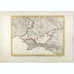
La Crimée, la nouvelle Russie, les Tatares Nugay et d'Oczakow...
Engraved by Perrier, Bourgoin and Arrivet. The map was prepared by the Venetian cartographer and publisher François (Père) Santini and first published in Santini's &quo...
Place & Date: Venice, 1784
Selling price: $110
Sold in 2015
Ingermanlandiae seu Ingriae novissima tabula luci tradita. . .
Detailed map centered on St. Petersburg. With imposing title cartouche and panoramic view of St. Petersburg. The map was drawn shortly after the conclusion of the Great N...
- $950 / ≈ €889
Place & Date: Nurenberg, 1780
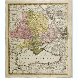
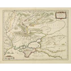
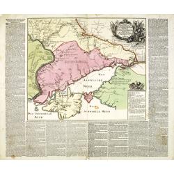
Tabula Geographica qua pars Russiae Magnae Pontus Euxinus seu mare Nigrum et Tartaria Minor cum finitimis Bulgariae, et Romaniae et Natoliae. . .
Homann's map is based upon Beauplan's general map of Ukraine but depicts the political changes of the preceding years. Shows Constantinople. Extends north to Moscow and S...
- $700 / ≈ €655
Place & Date: Nuremburg, 1750
Mappa Geographica Regni Poloniae ex novissimis quotquot sunt mappis specialibus composita et al L.L. Stereographicae projectionis revocata a Tob. Mayero. . . .
Decorative map of Poland after Tobias Mayer who was based on Barnikel's map of Curland (1747) and Jan Nieprzecki's map of Lithuania (1749).Poland extends from Glogau and ...
- $600 / ≈ €561
Place & Date: Nuremberg, 1757
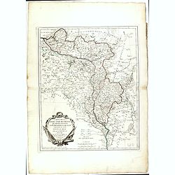
Ducatuum Livoniae et Curlandiae cum vicinis Insulis Nova Exhibitio Geographica. . .
Detailed map of the northern Baltic coast by Homann, pre-dating the privilege.
- $450 / ≈ €421
Place & Date: Nüremberg, 1720
Carte de la Lithuanie Prussienne qui comprend les Palatinats de Livonie, de Witepsk, de Liscislaw, et une partie de ceux de Polock et de Minsk cédés par la Pologne à la Russie. Dressée sur l'Exemplaire des Héritiers Homann 1775.
Detailed map of the areas along the river Dnieper and Duna. Santini gives credit to Homann Heirs in the cartouche.The map was prepared by the Venetian cartographer and pu...
- $300 / ≈ €281
Place & Date: Venice, 1776
Charte der Kriegs Operationen am Donn u: Dnieper Ihro Russisch Kayserl Majestaet Glorieusen Armeen A: 1736.
Very rare separately published map of the southern part of Ukraine, with an explanatory key A-N in the lower right. The map is surrounded by letterpress German text givin...
- $900 / ≈ €842
Place & Date: Augsburg, 1750
Moscovie dite autrement Grande et Blanche Russie.
Uncommon map of the Russia, including Finland, here with the date 1686.
- $500 / ≈ €468
Place & Date: Paris, 1686
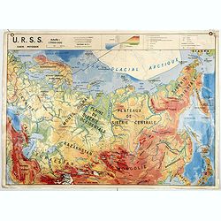
U.S.S.R. Carte Agricole. / U.S.S.R. Carte Industries et communications.
An unusual school map with on one side an agricultural map of Russia on verso a map of Russia showing communication an according to population. Prepared by Pierre Serryn ...
- $200 / ≈ €187
Place & Date: St-Germain-en-Laye, 1965
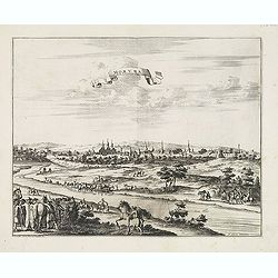
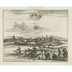
Moruma ville de la Tartarie Moscovite.
Decorative view of the town of Moruma, Russian city near the northern shore of the Caspian sea as seen from across the river Oka. This well executed engraving was publish...
- $300 / ≈ €281
Place & Date: Leiden, 1719-1727
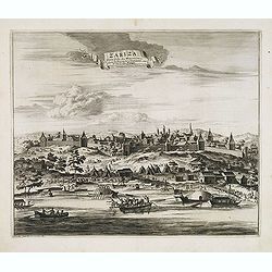
Zariza, petite ville des Moscovites, dans le royaume d'astracan, sur le bord du Wolga.
Decorative view of the town of Volgograd (Zarizyn) on the Volga River. This well executed engraving was published in 1729 and 1727 by Pieter van der AA, in Leiden in &quo...
- $300 / ≈ €281
Place & Date: Leiden, 1719-1727
Cassimogorod ville de la Tartarie Moscovite.
Decorative view of the town of Kasimov on the Oka River, east from Moscow and south from Murom near the northern shore of the Caspian Sea. The city is seen from across th...
- $300 / ≈ €281
Place & Date: Leiden, 1719-1727
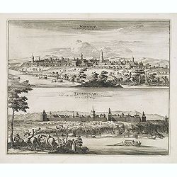
Soratof, ville de Tartarie Moscovite. / Tzornogar, Petite Ville des Moscovites, dans le Royaume d'Astracan, sur le bord du Volga.
Decorative engraving of two panoramic views in top Saratov with in the foreground the Volga River and in bottom a view of Chernyy Yar on the Volga River. This well execut...
- $300 / ≈ €281
Place & Date: Leiden, 1719-1727
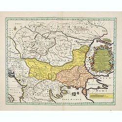
Illyricum Orientis In quo Partes II. Moesia et Thracia. Provinciae XI.
Attractive historical map of the area west of the Black Sea, today's Bulgaria, Rumania, etc. Based on the cartography of Nicolas Sanson and published by Covens and Mortie...
- $400 / ≈ €374
Place & Date: Amsterdam, c. 1720
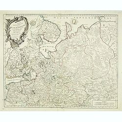
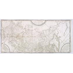
Partie Septentrionale de la Russie Europeenne ou sont distinguees exactement toutes les Provinces, d'apres le detail de l'Atlas Russien, Par le Sr. Robert de Vaugondy fils, Geog. Ordin? Du Roi.
Detailed map of northern European Russia, including Finland. The map was first published by the Venetian cartographer and publisher François (Père) Santini and first pu...
- $400 / ≈ €374
Place & Date: Venice, 1784
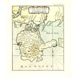
Carte de la Crimée.
Fine map of Crimea (Ukraine) here in the only issue of this version of Bellin's map, slightly larger than the common version. From Bellin's Le Petit Atlas Maritime Recuei...
- $175 / ≈ €164
Place & Date: Paris, 1764
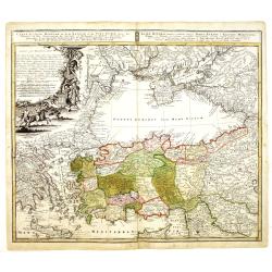
Carte de L'Asie Mineure ou de la Natolie et du Pont Euxin
Johann Baptist Homann's well-engraved map of Asia Minor, the Black Sea ( Ponti Euxin), Crimea and a part of Greece. Depicts Turkey and the area surrounding the Black Sea ...
- $500 / ≈ €468
Place & Date: Nuremberg, ca. 1748