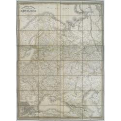
Browse Listings in Europe > Russia / Baltic / Black Sea region
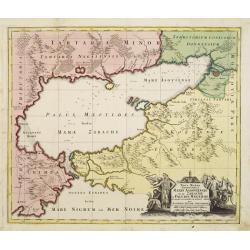
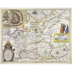
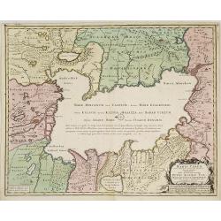
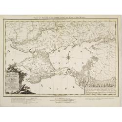
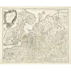
Maris Assoviensis vel de Zabache et Paludis Maeotidis. . .
A very detailed map showing the Black Sea, Azow and Rostow area.
Place & Date: Augsburg, 1720
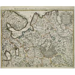
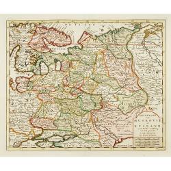
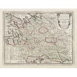
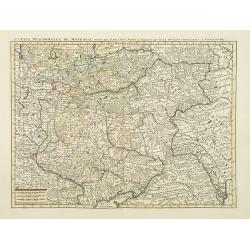
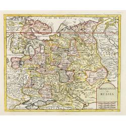
Carte de Moscovie. . .
Centred on Moscow, including Lapland. With fine uncolored title cartouche.
Place & Date: Amsterdam, 1720
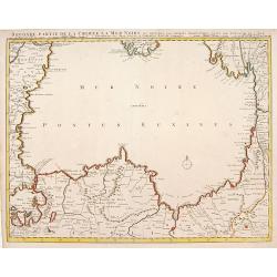
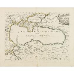
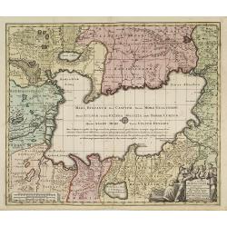
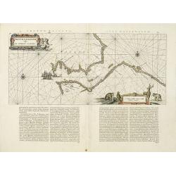
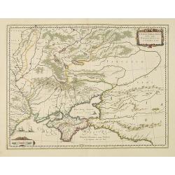
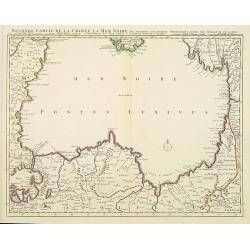
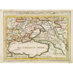
Seconde partie de la Crimee la Mer Noire. . .
The lower part of a set of two maps from the observations of Guillaume Delisle focuses on the Black Sea with wonderful detail of the surrounding regions. Includes Constan...
- $500 / ≈ €468
Place & Date: Amsterdam, 1720
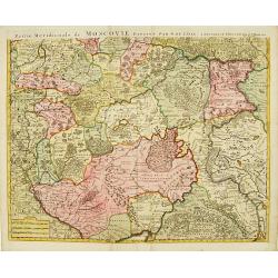
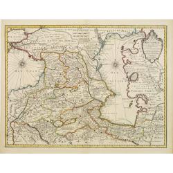
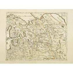
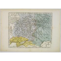
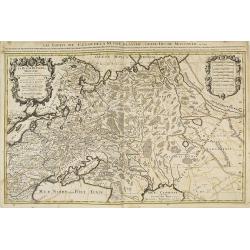
Partie Meridionale de Moscovie..
Centered on Moscow, including Azow in the bottom part of the map.The Amsterdam publishing firm of Covens and Mortier (1721 - c. 1862) was the successor to the extensive p...
- $300 / ≈ €281
Place & Date: Amsterdam 1720
Nieuwe Kaart van Muskovie of Rusland..
Detailed map of European Russia, far south to the Black Sea and Caspian Sea. Isaac Tirion was born in Utrecht ca. 1705. He came to Amsterdam ca. 1725. Tirion published a ...
Place & Date: Amsterdam, 1734
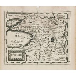
Géorgie.
Uncommon miniature map of Ukraine, from Pierre Duval's La Geographie Universeille dated 1676. Following his Cartes de geographie in 1657, Pierre Duval published this smal...
Place & Date: Paris, 1676
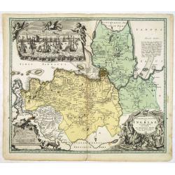
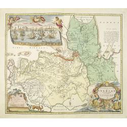
Ingermanlandiae seu Ingriae. . .
Detailed map centered on St.Petersburg. With imposing title cartouche and panoramic town-view of St.Petersburg. The map was drawn shortly after the conclusion of the Grea...
- $750 / ≈ €702
Place & Date: Nurenberg, 1780
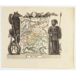
Russie
Attractive map of Russia with decorative borders depicting typical artefacts and produce of the continent. Published in Les jeunes voyageurs en Europe.. . Engraved by J.G...
- $100 / ≈ €94
Place & Date: Brussels, 1824
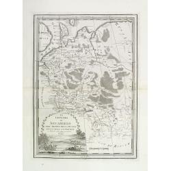
Partie de la Mer Glaciale contenant de la nouvelle Zemble..
A good engraved map of Nova Zembla. The geographical features are typical with somewhat exaggerated bays and inlets. From l'Histoire générale des voyages .
- $80 / ≈ €75
Place & Date: Paris, 1758
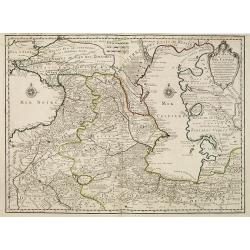
Carte des Pays voisins de la Mer Caspiene. . .
A most attractive and detailed map of the region between the Black and Caspian Seas after De L'Isle. The two Seas are decorated with compass roses. This is one of the few...
- $500 / ≈ €468
Place & Date: Amsterdam, 1720
La Russie Blanche ou MOSCOVIE.
Scarce miniature map centered on Moscow, from the rare atlas " El atlas abreviado, o compendiosa geografia del mundo antiguo, y nuevo. . ." by Francesco de Affe...
Place & Date: Antwerp, Jan Duren, 1698
Selling price: $100
Sold in 2012
Alexandri Magni Imperium et Expeditio per Africam et potissimum per Aslam.
Rare map of the Empire of Alexander the Great, prepared by J.B.Nolin and published by Monhare for his Atlas Général a l'usage des colleges et maisons d'education.. Cent...
- $300 / ≈ €281
Place & Date: Paris, 1783

Vue de la superbe Gallerie de Petersbourg en Russie.
So-called optical print illustrates a perspective view of the interior of a palace in Saint Petersburg.Mondhare was a well-known publisher of optical prints, established ...
- $200 / ≈ €187
Place & Date: Paris, 1761
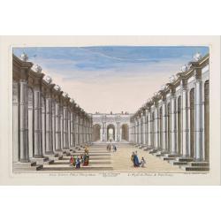
15e. Vüe d'Optique Representant Le Profil du Palais de Petersbourg.
So-called optical print illustrating a perspective view of the portico of a Palace in Saint Petersburg. Published by Daumont, a well-known publisher of optical prints, es...
- $250 / ≈ €234
Place & Date: Paris, 1760

Vuë de l'ancien Palais d'hiver de sa Majesté Imperiale et du Canal qui Joint la Moika avec la Neva, a St. Petersburg.
So-called optical print illustrating a perspective view of St. Petersburg, namely the ancient Winter Palace and the canal which joins the Moika to the Neva.In the eightee...
Place & Date: Paris, 1760
Estats du Grand Duc de Moscovie ou de L'Empereur de la Russie Blanche. . .
Lovely small map of central Russia with decorative title cartouche and a panel in the lower left corner listing local rulers.From Le Nouveau et Curieux Atlas Geographique...
- $150 / ≈ €140
Place & Date: Paris, 1719
Moscovie dite autrement Grande et Blanche Russie.
Uncommon map of the Russia, including Finland, here with the date 1686.
- $500 / ≈ €468
Place & Date: Paris, 1686
Mer Noire ou Mer Maievre, . . .
Map of the Black Sea prepared by N.Sanson and published by Pierre Mariette.Published in an early edition of the small Sanson atlas L'Europe Dediée a Monseigneur . . . Le...
Place & Date: Paris, P. Mariette, 1667
Russie Blanche ou Moscovie.
Map of the European part of Russia prepared by N.Sanson and published by Pierre Mariette.Published in an early edition of the small Sanson atlas L'Europe Dediée a Monsei...
Place & Date: Paris, P. Mariette, 1667
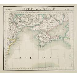
Partie Méridionale de la Russie Européenne, Tartarie, Russienne, Petite Tartarie.
Map of the southern part of Russia and Tartary. By C. F. Delamarche, successor of Robert de Vaugondy, Geographer.
- $90 / ≈ €84
Place & Date: Paris, 1806
![[Crimea]. Carte de la Cromée.](/uploads/cache/25719-250x250.jpg)
[Crimea]. Carte de la Cromée.
Mapmaker, Captain Jan Hendrik van Kinsbergen (1735-1819). Published by H. Friesman in 1787. This map first appeared in 1776 and was the first Russian map of the newly ann...
Place & Date: Amsterdam, H. Frieseman, 1787
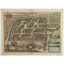
Moscavw. Moscovia, Urbs regionis eiusde nominis metropolitica, duplo maior. . .
Showing Moscow within the walled city and figures in the foreground. Title cartouche in the lower right corner Moscovia, Urbs. Regionis ciusde nominis metropolitica, dup...
Place & Date: Cologne, 1580
Selling price: $2600
Sold in 2009
Partie Septentrionale de la Russie Européenne . . .
Detailed map of European part of Russia, including Finland and Lapland.
Place & Date: Paris, 1780
Nouvelle Carte de la Petite Tartarie et la Mer Noire, montrant les Frontieres de l'Impératrice de Russie et de l'Empereur des Turcs, tant en Europe qu'en Asie, Dessigné selon la proposition de G. De L'Isle et d'autres Auteurs.
The Ukraine and the Black Sea in a fine impression with original 18th-c. hand-coloring.
- $1250 / ≈ €1170
Place & Date: Amsterdam, 1730
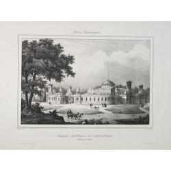
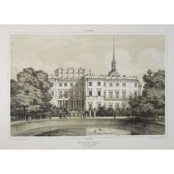
Palais Impérial de Petrowski. Environs de Moscou. N° 17.
Decorative view of the Imperial Palace of Petrowski. After a design by Vander Burch. Printed by L.Turgis active in Paris and New York. Turgis is best known for his series...
- $200 / ≈ €187
Place & Date: Paris, ca. 1850-1860
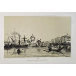
Cathédrale d'Isaac et Palais du Sénat. Vue prise de la Néva. (17 juillet 1839).
A view from the port of the Isaac Cathedral and the Senat Palace in Saint Petersburg on July 17 1839. Plate taken from the first illustrated account of Russian architectu...
Place & Date: Paris, 1845
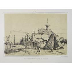
Village sur la route de Moscou. (9 Août 1839).
A view of a village on the way to Saint Petersburg on August 9 1839. Plate taken from the first illustrated account of Russian architecture. This publication was the proj...
Place & Date: Paris, 1842
Palais de Paul 1er. Côté du Jardin d'Eté. (16 Juillet 1839).
A view of Paul the First Palace in Saint Petersburg on August 9 1839. Figures are lithographed by Raffet. Plate taken from the first illustrated account of Russian archit...
Place & Date: Paris, 1844
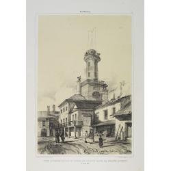
Tour d'Observation et siège de police dans la grande Morskoi. (2 Juillet 1839).
A view of Observation Tower and police headquarters in the Morskoi in Saint Petersburg on August 9 1839. Plate taken from the first illustrated account of Russian archite...
Place & Date: Paris, 1840
Selling price: $250
Sold in 2013
Tabula Russiae ex autographo, quod delineandum curavit Foedor filius Tzaris Boris desums... - Domino regionum Iueriae Kartalinie et Groefiniae Tzari etc: dedicata ab Heselo Gerardo M.DC.XIIII
A re-issue, by Willem Blaeu, of Hessel Gerritsz' rare and influential map of Russia. Dutch text on verso, extending west to east from Emden to Aspachan and north to south...
Place & Date: Amsterdam, 1635
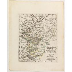
Impero della Russia in Europa a riserva delle ultime Conquiste sulla Polonia.
Charming map of the European part of Russia, including Finland, from the rare atlas Atlante Tascabile o sia Serie di Num. XXI Cartine Geografiche nelle quali si In Roma...
- $200 / ≈ €187
Place & Date: Rome, 1823

Nova Maris Caspii et Regions Usbeck..
A detailed map of part of Russia, Central Asia centered on the Caspian, Uzbek territory to the east of the Caspian and northern Persia. A finely engraved, uncolored title...
Place & Date: Nuremberg, 1735
![ATLAS RUSSICUS mappa una generali et undeviginti specialibus vastissimum Imperium Russicum cum adiacentibus regionibus [repeated in French].](/uploads/cache/27877-250x250.jpg)
ATLAS RUSSICUS mappa una generali et undeviginti specialibus vastissimum Imperium Russicum cum adiacentibus regionibus [repeated in French].
After an unnumbered general map of Russia there are 13 numbered maps that cover European Russia (scale 1, 1.527.000). The other (last) 6 maps cover Asian Russia (Siberia,...
Place & Date: St Peterburg, Akademie von Wissenschaften. 1745

Imperii Russici et Tartariae Universae tabula novissima.
Decorative and rare map covering Russia, Tibet, China, Tartary, Korea, Taiwan and Japan prepared by J. M. Hasius. The sea between Japan and Korea is mentioned Mare Orient...
Place & Date: Utrecht, 1743
![[2 maps and one text sheet] Theatrum Belli A° MDCCXXXVII. . . / Verus Chersonesi Tauricae Seu Crimea Conspectus adjacentium item Regionem itinerisq ab Exercitu Ruthemo...](/uploads/cache/27975-250x250.jpg)
[2 maps and one text sheet] Theatrum Belli A° MDCCXXXVII. . . / Verus Chersonesi Tauricae Seu Crimea Conspectus adjacentium item Regionem itinerisq ab Exercitu Ruthemo...
[2 maps and one text sheet] Theatrum Belli A° MDCCXXXVII. . . / Verus Chersonesi Tauricae Seu Crimea Conspectus adjacentium item Regionem itinerisq ab Exercitu Ruthemo A...
- $1100 / ≈ €1029
Place & Date: Amsterdam, c. 1744
General karte vom europaischen Russland.
Rare second edition of a lithographed wall map of the European part of the Russian empire, at a scale of about 1:3,200,000. With the title in a elaborately decorated lett...
Place & Date: Weimar, Geographisches Institut, 1840
Partie Meridionale de Moscovie. . .
Scarce map centered on Moscow including Azow and part of present-day Ukraine in the bottom part of the map. The map is based on Delisle's important map of the region with...
- $750 / ≈ €702
Place & Date: Amsterdam, 1720
Carte marine de la mer Caspienne avec toutes ses Bayes Rivieres et Havres, dressée sur les observations des plus habiles Navigateurs,. . .
Strikingly engraved and attractive map of the Caspian Sea, showing major towns, ports, etc. Large decorative cartouche and compass rose.
- $1000 / ≈ €936
Place & Date: Leiden, 1710

Carte particulière des environs de St Peters-bourg. . . / Plan de la ville faubourg et environs de St Petersbourg. . . / Carte pour l'intelligence de la guerre de Moscovie et de Suede. . .
A scarce and unusual plan of Saint Petersburg shown at a large scale and also, in a separate compartment, shown in its geographical context between the Gulf of Finland an...
Place & Date: Paris, c.1741
Nova ac verissima Maris Caspii ante hac maximam fere partem nobis incogniti, ac Regionum adiacentium : Delineatio Iussu Invictissimi Principis Petri Alexii Fil. Magni Russorum Imperatoris / immenso labore et maximis sumptibus facta, atque ex ...
Covers portions of Iran, Turkmenistan, Kazakhstan, Russia and Azerbaijan. Relief is shown pictorially. Depth is shown by soundings. Oriented with north to the left. Rare.
- $750 / ≈ €702
Place & Date: Amsterdam, 1720
Carte du Gouvernement de Tauride, comprenant la Krimée et les pays voisins: dressée principalement d'après la carte faite sur les lieux pour le voyage de S.M. l'impératrice de Russie. . .
Very rare map of the Crimea area published Jean-Claude Dezauche, who was active in Paris 1770-1824. The map includes borders and a road system.Dezauche is giving credit t...
- $1250 / ≈ €1170
Place & Date: Paris, 1788
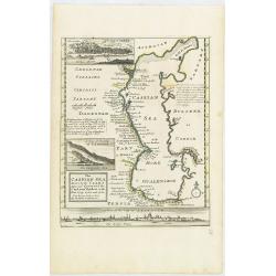
Nova et accuratissima Maris Caspii. . .
Original hand colored copper engraving of Matthaeus Seutter. Showing the Caspian Sea with the large Volga Delta in east orientation. Main towns / countries around the Cas...
- $1000 / ≈ €936
Place & Date: Augsburg, 1740
La Russie blanche ou moscovie. . .
Fine map of the European part of Russia with a decorative title and scale cartouche.Alexis-Hubert Jaillot (1632-1712), was a French cartographer. He joined the Sanson hei...
Place & Date: Amsterdam, 1692
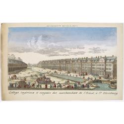
Colléges impériaux et magasin des marchandises de l'Orient, à St. Pétersbourg.
Showing a busy scene at the international trading grounds of 18th century Saint Petersburg, showing the warehouses of the different international trading companies. J. Ch...
- $200 / ≈ €187
Place & Date: Paris, ca. 1750
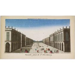
Nouvelle place de St. Pétersbourg.
Showing a square at 18th century Saint Petersburg. J. Chereau was a publisher of optical prints, established in Paris, rue St.Jacques.In the eighteenth and nineteenth ce...
- $200 / ≈ €187
Place & Date: Paris, ca. 1750

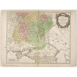
Tabula geographica Russiae Magnae pontus euxinus seu mare nigrum et tauriae regnum. . .
Decorative map of the Black Sea Region, with a large decorative cartouche. Shows Constantinople. Extends north to Moscow and Smolensko.
- $750 / ≈ €702
Place & Date: Nuremberg, 1720
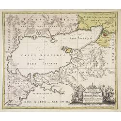
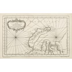
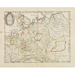
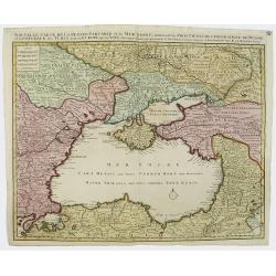
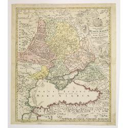
Maris Assoviensis vel de Zabache et Paludis Maeotidis. . .
A very detailed map showing the Black Sea, Azow and Rostow area. With a decorative allegorical cartouche, showing the costumes of the indigenous people of the region.
- $900 / ≈ €842
Place & Date: Augsburg, 1720
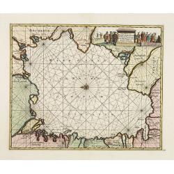
Fretum Nassovium vulgo de Straet Nassou.
Decorative map of the Nassau Strait, from the Atlas Major. Includes 2 compass roses, sailing ships, rhumb lines and 2 elaborate cartouches. Latin text below and on verso....
Place & Date: Amsterdam, 1662

Carte Marine De La Mer Caspiene levée suivant les ordres de S.M.Cz. En 1719, 1720 et 1721.
Detailed of the Caspian Sea, prepared by Karl van Verden in 1722. Van Verden was a Russian sailor and the Czar's Special Commander, who produced the first accurate map of...
Place & Date: Paris, ca. 1725

Carte de la Petite Tartarie Dresee par ordre de l'Imperatries de toutes las Russies.
The very rare first edition of De Leth's map of the southern part of Ukraine, with detailed annotations regarding the Cossacks and an explanatory key. Based on a Russian ...
- $1750 / ≈ €1638
Place & Date: Amsterdam, ca. 1785
The Caspian Sea Drawn by the Czar's special command By Carl van Verden in the year 1719. 1720 and 1721. . .
Hand col. engraved map with 3 inset views. Includes geographical notes.With views of "Terky", "Derbent" and "Astracan"
Place & Date: London, 1732
Selling price: $375
Sold in 2011

Vue d'un château d'Archangel.
So-called optical print of a street and house in Arkhangelsk, by the well-known publisher of optical prints, Basset, established in rue St.Jacques in Paris. In the eighte...
- $300 / ≈ €281
Place & Date: Paris, 1760
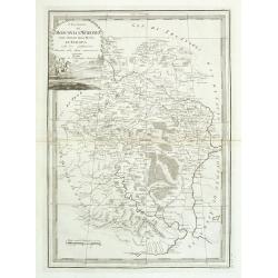
Partie Méridionale de la Russie Européenne. . .
Detailed map of Ukraine, the Crimea and the northern part of the Caspian Sea.
- $650 / ≈ €608
Place & Date: Paris, 1752
Il governo di arcangelo nell' impero della russia diviso. . .
Detailed map of the northern part of the Russian Empire with a decorative title cartouche. In the upper left corner part of the Baltic Sea with Lapland. Published in the ...
Place & Date: Rome, 1795-1796
I Governi Di Moscovia E Woronez Nell' Impero Della Russia In Europa . . .
Rare and highly decorative regional map of Russia. The map is centered on Moscow and covers the region bounded by the course of the Volga River from north of Romanow to t...
- $350 / ≈ €328
Place & Date: Rome, 1795
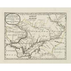
Des Russischen Reiches Statthalterschaften Neurussland, Asow, und das Oestliche Nogay
Map showing Lake Asow and the Crimea. The river Dnepr until Krementschug, and the river Don until Pawlowsk. Published by Franz Johann Joseph von Reilly.
Place & Date: Vienna, 1789
Ingermanlandiae seu Ingriae novissima tabula luci tradita. . .
Detailed map centered on Saint Petersburg. With imposing title cartouche and panoramic view of Saint Petersburg. The map was drawn shortly after the conclusion of the Gre...
Place & Date: Nurenberg, 1780
Taurica Chersonesus, Nostra aetate Przecopsca, et Gazara dicitur.
Part of Russia with in the north Smolensk and Moscow and in the south the Black Sea.As Willem Blaeu died in 1638 most of his maps are actually published by his son Joan. ...
Place & Date: Amsterdam, 1638
Europe. Partie de la Russie. N°22.
Detailed map of the Crimea region.From his famous Atlas Universel . This atlas was one of the most remarkable world atlases ever produced, anticipating the International ...
Place & Date: Brussels, 1825-1827
Selling price: $210
Sold in 2010
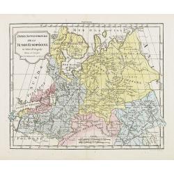
Partie Septentrionale de la Russie Européenne . . .
Detailed map of European part of Russia, including Finland, Lapland.
Place & Date: Paris, 1753
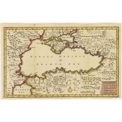
Seconde partie de la Crimee la Mer Noire. . .
The lower part of a set of two maps from the observations of Guillaume Delisle focusing on the Black Sea with wonderful detail of the surrounding regions. Includes Consta...
- $750 / ≈ €702
Place & Date: Amsterdam, 1720
Carte des Pays Voisins de la Mer Caspiene dressee pour l' usage du Roy. . .
Detailed and attractive map focusing on Georgia, Azerbaijan and Armenia. It depicts roads, forts, cities, villages, topography and is filled with notations.Prepared by th...
- $750 / ≈ €702
Place & Date: Paris, 1723
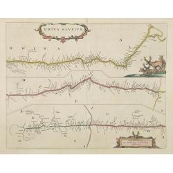
Dwina Fluvius.
Covens and Mortier's re-print of Joan Blaeu's map of 1662, first issued in the Atlas Maior. The course of the river from its source, a confluence in the Vologod Province ...
Place & Date: Amsterdam, 1700
Selling price: $500
Sold in 2010

Moscovia urbs Metropolis totius Russiae Albae.
Detailed bird's-eye town-plan of Moscow from Janssonius' rare townbook. With a key (1-20) to important spots in town. The verso has French text and originates from Jansso...
Place & Date: Amsterdam, 1657
![[No title] Russland.](/uploads/cache/28943-250x250.jpg)
[No title] Russland.
Map depict the area north of the Black Sea, including the cities of Odessa, Kischenau, Jelisawetgrad, Kherson.From "W. E. A. von Schliebens Atlas von Europa nebst Ko...
- $250 / ≈ €234
Place & Date: Leipzig, G. J. Göschen, ca 1825-1830
![[No title] Russland.](/uploads/cache/28944-250x250.jpg)
[No title] Russland.
Map depict the area north of the Black Sea, including the cities of Jekaterinoslaw, Bachmut, Alexandrowsk.From "W. E. A. von Schliebens Atlas von Europa nebst Koloni...
- $300 / ≈ €281
Place & Date: Leipzig, G. J. Göschen, ca 1825-1830
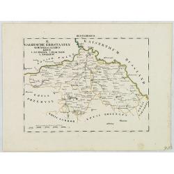
B. Galizische Erbstaaten Koenigr: Galizien Kreis 1. Lemberg 2. Zloczow 3. Zolkiew.
Map depict the western part of the Ukraine, centered on the town of Lviv (Lemberg) the former capital of the region of Galicia. Other cities are Zolkiew, Brody, Belz.From...
- $300 / ≈ €281
Place & Date: Leipzig, G. J. Göschen, ca 1825-1830
![[No title] Oesterreich. B. Galizische erbstaaten Koenigr. Galizien Kreis 12. Sambor 13. Stry 17. Stanislawow.](/uploads/cache/28948-250x250.jpg)
[No title] Oesterreich. B. Galizische erbstaaten Koenigr. Galizien Kreis 12. Sambor 13. Stry 17. Stanislawow.
Map depict the area north of the Black Sea, including the cities of Stanislawow, Drobicz, Sambor.From "W. E. A. von Schliebens Atlas von Europa nebst Kolonien für G...
- $300 / ≈ €281
Place & Date: Leipzig, G. J. Göschen, ca 1825-1830
![[No title] Russland. Gouv. 24 Woronesh 28. Slobodsk Ukraine.](/uploads/cache/28949-250x250.jpg)
[No title] Russland. Gouv. 24 Woronesh 28. Slobodsk Ukraine.
Map depict the area north of the Black Sea, including the cities of Kharkow, Achtyrka, Woronesh, etc.From "W. E. A. von Schliebens Atlas von Europa nebst Kolonien f�...
- $300 / ≈ €281
Place & Date: Leipzig, G. J. Göschen, ca 1825-1830
Smolensko.
View of this small town in Russia just before the First Battle of Smolensk which took place on August 17, 1812, between 175,000 men of the army under Napoleon Bonaparte a...
- $225 / ≈ €211
Place & Date: London, 1814

Saint Petersbourg. Maison de bienfaisance, appartenant à Mr Anatole de Demidoff. . .
Beautiful lithography showing the house of Anatole de Demidoff in Saint Petersburg.
Place & Date: Paris, c. 1850

L'escadre alliée bombarde les forts extérieurs de Sébastopol. (18 octobre 1854)
Beautiful Crimean War lithography by Becquet after a painting by Louis Le Breton. The print illustrates the ships "Fort Constantin", "la ville de Paris&quo...
Place & Date: Paris, 1860

Ajustement des Femmes de Valday Situé entre Petersbourg et Moscou.
Etching by Jean-Baptiste Le Prince (1734-1781), from "2me Suite de divers cris de marchands de Russie", showing typical russian customs. The sketches Le Prince ...
- $110 / ≈ €103
Place & Date: Paris, 1764
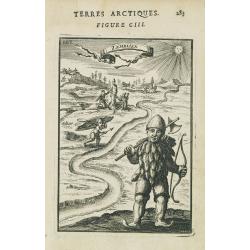
Zemblien.
Engraving presenting inhabitants of Nova Zembla from his monumental work "Description de L'Univers."
Place & Date: Paris, 1685
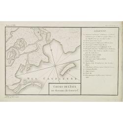
Cours de l'Iaik au dessous de Gourief.
Engraved map of the estuary of the river Ural south of Gurjev. Map from a second French edition of Peter Simon Pallas' Voyages du Professeur Pallas, dans Plusieurs Provin...
Place & Date: Paris, Maradan, 1794
Selling price: $60
Sold in 2010
Russia in Europe.
From S. Augustus Mitchell’s "A New Universal Atlas". Philadelphia. Lithographic transfer from engraved plate. A fine map of Russia in Europe from the mid-nine...
- $80 / ≈ €75
Place & Date: Philadelphia, c.1846
Tabula Geographica qua pars Russiae Magnae. . .
U unrecorded state Homann's map is based upon the works of George von Mengden (1628-1702), a Livonian cartographer who worked for Peter the Great and Count Jacob Bruce [G...
- $1000 / ≈ €936
Place & Date: Nuremberg, c. 1770
Assoph, Asow, oder Azak mit der Kleinen Tartarey dem Scwharzen Meer. . .
Scarce map showing the Black Sea region with Southern Ukraine, Georgia and Armenia.
- $100 / ≈ €94
Place & Date: Augsburg, 1715
Moscovia o Russia.
Map showing European Russia and is centered on Moscow. In the lower right corner, title cartouche with scale and the town of Astrakhan. From "Atlante Novissimo Che C...
Place & Date: Venice, 1740
Nieuwe kaart van de Crim de Zwarte Zee en omleggende. . .
Showing the Black Sea and the Marmara Sea with Istanbul. Published in the rare first edition of Kleyne en Beknopte Atlas, of Tooneel des Oorlogs in Europa...The atlas wa...
Place & Date: Amsterdam, 1735
Selling price: $450
Sold in 2013