Browse Listings in Europe > Eastern Europe
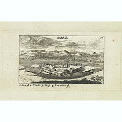
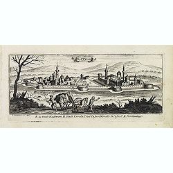
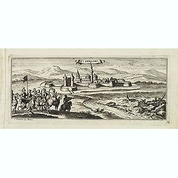
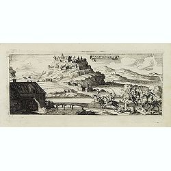
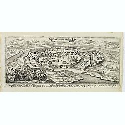
Sabaz. (Sabac)
View of Šabac in western Serbia, along the Sava river.Published in "Der Donau-Strand Mit allen seinen Ein- und Zuflüssen. . .". Published by Jacob Sandrart.
- $75 / ≈ €66
Date: Nuremberg, Jacob Sandrart, 1684
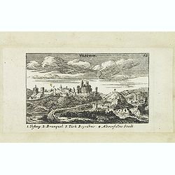
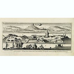
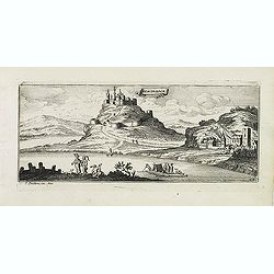
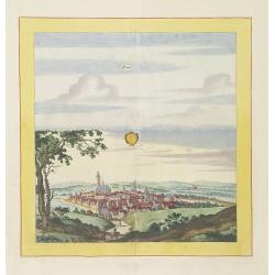
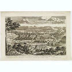
Vesprin.
Panoramic view of Veszprém is one of the oldest urban areas in Hungary, and a city with county rights. It lies approximately 15 km north of the Lake Balaton. Published in...
- $90 / ≈ €79
Date: Nuremberg, Jacob Sandrart, 1684
![Weitzen [Vác / Waitzen]](/uploads/cache/30817-250x250.jpg)
Weitzen [Vác / Waitzen]
Panoramic view of Vác / Waitzen with the Donau in the foreground Published in "Der Donau-Strand Mit allen seinen Ein- und Zuflüssen. . .". Published by Jacob Sa...
- $90 / ≈ €79
Date: Nuremberg, Jacob Sandrart, 1684
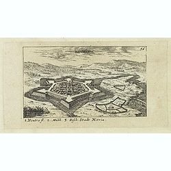
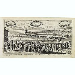
Neuhäusl. (Nové Zámky)
Panoramic view of Nové Zámky, in southwestern Slovakia.Published in "Der Donau-Strand Mit allen seinen Ein- und Zuflüssen. . .". Published by Jacob Sandrart.
- $75 / ≈ €66
Date: Nuremberg, Jacob Sandrart, 1684
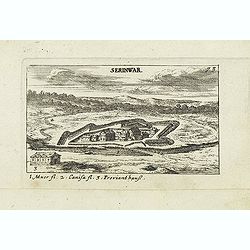
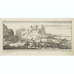
Serinwar. (Zrínyi vár)
Panoramic view of Zrínyi vár in Hungary. Published in "Der Donau-Strand Mit allen seinen Ein- und Zuflüssen. . .". Published by Jacob Sandrart.
- $90 / ≈ €79
Date: Nuremberg, Jacob Sandrart, 1684
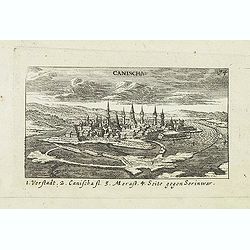
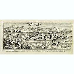
Canischa. (Nagykanizsa / Kanizsa)
Panoramic view of Nagykanizsa / Kanizsa. Published in "Der Donau-Strand Mit allen seinen Ein- und Zuflüssen. . .". Published by Jacob Sandrart.
Date: Nuremberg, Jacob Sandrart, 1684
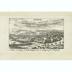
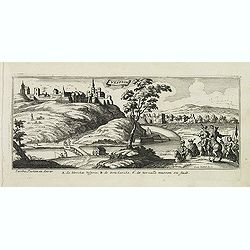
Zolnok.
Panoramic view of Szolnok (solnok) is the county seat of Jász-Nagykun-Szolnok county in central Hungary. Its location on the banks of the Tisza river, at the heart of the...
- $75 / ≈ €66
Date: Nuremberg, Jacob Sandrart, 1684
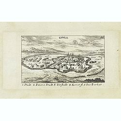
Gyula.
Panoramic view of Gyula in Békés County, Hungary. The town is best known for its Medieval castle and thermal bath. Published in "Der Donau-Strand Mit allen seinen Ei...
- $75 / ≈ €66
Date: Nuremberg, Jacob Sandrart, 1684
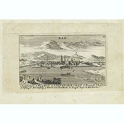
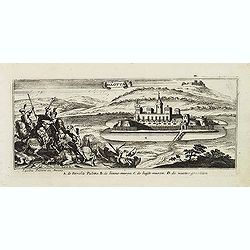
Rab. / Leopoldina. / Der Grosse und wunderbare Comet. . .
On recto panoramic view of Raab or Gyor, the Hungarian town on the Danube. On verso a plan of Leopoldina and a view of comet. Published in "Der Donau-Strand Mit alle...
- $90 / ≈ €79
Date: Nuremberg, Jacob Sandrart, 1684
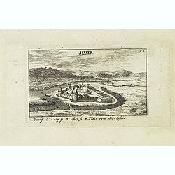
Sissek.
Panoramic view of Sisak in Sisak in central Croatia. Published in "Der Donau-Strand Mit allen seinen Ein- und Zuflüssen. . .". Published by Jacob Sandrart.
- $75 / ≈ €66
Date: Nuremberg, Jacob Sandrart, 1684
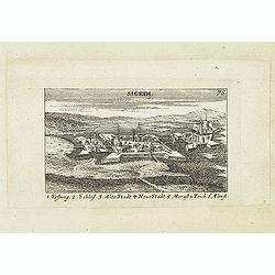
Sigeth.
Panoramic view of Sigeth. Published in "Der Donau-Strand Mit allen seinen Ein- und Zuflüssen. . .". Published by Jacob Sandrart.
Date: Nuremberg, Jacob Sandrart, 1684

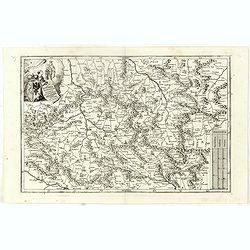
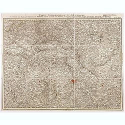
Le Cours de l'Elbe et de l'Oder où sont les Electorats de Saxe et de Brandebourg, les Duchés de Mekelbourg et de Pomeranie. . .
A detailed and scarce map showing the rivers Elbe and Oder in Germany and Poland. Dark engraving.This is one sheet of the four sheet wall map by Pierre Du Val entitled: &...
Date: Paris, 1684
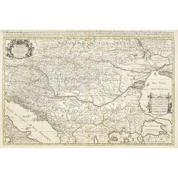
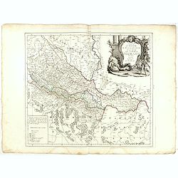
La Bulgaria ela Romania con Parte di Marcedonia. . .
Scarce map of the region along the Danube River and to the south. Extends to include part of the Sea of Azov and the northern extreme of the Aegean Sea. Elaborate militar...
Date: Rome, 1689
Rechnitz / Lewentz. (Breznica and Levice)
Magnificent bird's eye- of Breznica and Levice in Slovenia. Etched by Gaspar Bouttats (1640-1695).The Antwerp based publisher Jacques Peeters published ca. 1690 a series ...
Date: Antwerp, c.1690
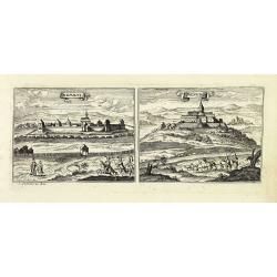
Haftwan. (Hatvan)
Magnificent bird's eye- of Hatvan. Etched by Gaspar Bouttats (1640-1695).The Antwerp based publisher Jacques Peeters published ca. 1690 a series of prints related to the ...
Date: Antwerp, c.1690
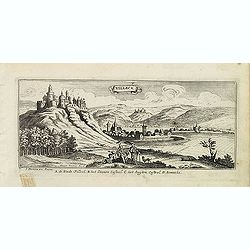
Villeck. (Filakovo)
Magnificent bird's eye- of Filakovo. Etched by Gaspar Bouttats (1640-1695).The Antwerp based publisher Jacques Peeters published ca. 1690 a series of prints related to th...
Date: Antwerp, c.1690
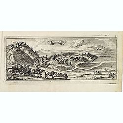
Sandrae. (Szendrö)
Magnificent bird's eye- of Szendrö. Etched by Gaspar Bouttats (1640-1695).The Antwerp based publisher Jacques Peeters published ca. 1690 a series of prints related to the...
Date: Antwerp, c.1690
Tockay. (Tokaj)
Magnificent bird's eye- of Tokaj. Etched by Gaspar Bouttats (1640-1695).The Antwerp based publisher Jacques Peeters published ca. 1690 a series of prints related to the H...
Date: Antwerp, c.1690
Sixo / Kalo. (Szikszo and Nagycallo)
Magnificent bird's eye- of Szikszo and Nagycallo. Etched by Gaspar Bouttats (1640-1695).The Antwerp-based publisher Jacques Peeters published ca. 1690 a series of prints ...
Date: Antwerp, c.1690
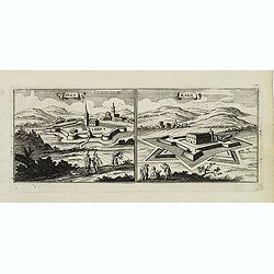
St:Servaes. (Szarvas)
Magnificent bird's eye- of Szarvas. Etched by Gaspar Bouttats (1640-1695).The Antwerp based publisher Jacques Peeters published ca. 1690 a series of prints related to the...
Date: Antwerp, c.1690
Canisia.
Magnificent bird's eye- of Nagykanizas. Etched by Gaspar Bouttats (1640-1695).The Antwerp based publisher Jacques Peeters published ca. 1690 a series of prints related to...
Date: Antwerp, c.1690
Nembti / Sengrot.
Magnificent bird's eye-town-views of Lenti and Zalaszengrot. Etched by Gaspar Bouttats (1640-1695).The Antwerp based publisher Jacques Peeters published ca. 1690 a series...
Date: Antwerp, c.1690
St Martinsbergh.
Magnificent bird's eye- of Pannonhalma (Szentmártonhegy). Etched by Gaspar Bouttats (1640-1695).The Antwerp based publisher Jacques Peeters published ca. 1690 a series of...
Date: Antwerp, c.1690
Schombock.
Magnificent bird's eye- of Zsambek. Etched by Gaspar Bouttats (1640-1695).The Antwerp based publisher Jacques Peeters published ca. 1690 a series of prints related to the...
Date: Antwerp, c.1690
Palotta.
Magnificent bird's eye- of Varpalota. Etched by Gaspar Bouttats (1640-1695).The Antwerp based publisher Jacques Peeters published ca. 1690 a series of prints related to t...
Date: Antwerp, c.1690
Vesprin.
Magnificent bird's eye- of Veszprem. Etched by Gaspar Bouttats (1640-1695).The Antwerp based publisher Jacques Peeters published ca. 1690 a series of prints related to th...
- $125 / ≈ €109
Date: Antwerp, c.1690
Stoe-Wysenburg.
Magnificent bird's eye- of Szekesfehervar. Etched by Gaspar Bouttats (1640-1695).The Antwerp based publisher Jacques Peeters published ca. 1690 a series of prints related...
- $125 / ≈ €109
Date: Antwerp, c.1690
Esseker brugh.
Fine print of the Esseker bridge in Osijek. Etched by Gaspar Bouttats (1640-1695).The Antwerp based publisher Jacques Peeters published ca. 1690 a series of prints relate...
- $125 / ≈ €109
Date: Antwerp, c.1690
Guyla.
Magnificent bird's eye- of Gyula. Etched by Gaspar Bouttats (1640-1695).The Antwerp based publisher Jacques Peeters published ca. 1690 a series of prints related to the H...
- $125 / ≈ €109
Date: Antwerp, c.1690
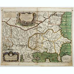
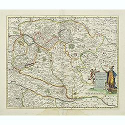
Parte della Schiavonia, overo Slavonia, aggiuntavi la contea di Cilles e Windisch mark abitate da populi slavini, ò slavi. . .
The map of Slavonia by Cantelli from his atlas “Mercurio Geografico” issued in Rome in 1690 by the publisher and printer Giacomo Rossi. The map shows parts of the medieva...
- $400 / ≈ €350
Date: Rome, 1690
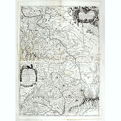
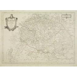
Le Royaume de Hongrie.
Fine oversized map of Hungary, but including Bosnia and Herzegovina, Bulgaria, Croatia, Romania, Albania, European part of Turkey, and Ukraine. With a decorative title an...
Date: Amsterdam, 1692
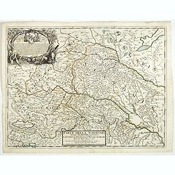
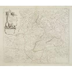
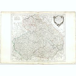
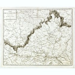
Il Ducato di Silesia et il Marchesato di Moravia
Scarce two-sheet map of the region along the River Oder in Poland, including parts of Chez Republic and Hungary. Excellent detail throughout. Large and decorative title a...
- $1200 / ≈ €1049
Date: Rome, 1692
![Praghe. [ Prague ]](/uploads/cache/27801-250x250.jpg)
Praghe. [ Prague ]
A rare panoramic of Prague with over the whole length of the lower part 3 columns of poems in Dutch, French, German and English.Frederick de Wit published after 1694 a t...
- $2100 / ≈ €1836
Date: Amsterdam, 1694
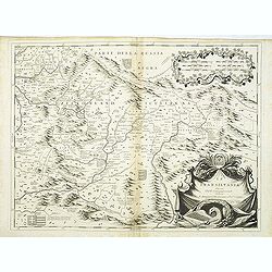
La Transilvania.
A scarce and very attractive detailed map of Transylvania and includes numerous coats of arms in the body of the map and a large decorative title cartouche. Scale cartouc...
Date: Venice, 1696

Marcomania hoggidi Merchesato de Moravia. . .
Although Komensky's map of Moravia was already known in his time, Coronelli used the obsolete map by Fabricius, with a lot of locations added by the publisher's unchained...
Date: Venice, 1696

Launa vulgo Laun Bohemiae civitas.
Bird's-eye views of Louny in Bohemia by G. Hoefnagel. The copperplate was made for Braun and Hogenberg's town book. However there the print has been transformed by the en...
Date: The Hague, 1700
Novissima et accuratissima totius Hungariae tabula. . .
Detailed map of Hungary with a decorative title cartouche with putti and an Ottoman warrior. The publisher gives credit to P. du Val in the title cartouche.
Date: Amsterdam, 1700
Laûn.
Very decorative and rare panoramic of Laun Louny a.d. Eger Böhmen.The engraver and publisher of prints, Mrs. Anna Beek of the Hague, enlarged the print and mounted it on...
Date: The Hague, ca. 1700
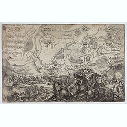
Delineatione della Piazza Forza di Belgrado.
Bird's-eye view of the Siege of Belgrade by the Austrian troops under the command of Prince Eugene of Savoy to capture the strategically important city from the Ottoman E...
Date: Rome, ca. 1700
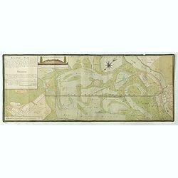
![Le Cours du Danube. . .[2 maps].](/uploads/cache/28472-250x250.jpg)
Le Cours du Danube. . .[2 maps].
Detailed two-sheet map of the course of the River Danube from its source up to Vienna. Showing the cities, like Linz, Passau, Straubing, Regensburg, Ulm, Augsburg, Munich...
Date: Paris, 1705
In Bohemia Moravia et Silesia . . .
A map of Czechoslovakia with Poland in the upper corner. Including the River Oder and Wroclaw (Breslaw)Heinrich Scherer (1628-1704) taught as Professor of Hebrew, Mathema...
- $175 / ≈ €153
Date: Munich c.1710
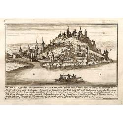
Belgrad / Biograd.
A very RARE panoramic view of the city of Belgrade, including a numbered legend in the lower part.Published by the brothers Chéreau, active in Paris at rue st.Jacques au ...
Date: Paris, c.1720

Vue et description des principales villes de l'Armenie et de la Georgie avec les habillements des femmes du pays, et ceux des prêtres et religieux armeniens. . .Tom: V N° 11 Pag: 28
View and description of the principal Armenian and Georgian cities with illustrations of Armenian women's garments as well as priests' and monks' clothing. The views are ...
Date: Amsterdam, ca 1720
Bude Ville capitale de la Hongrie.
A rare panoramic town-view of the city of Budapest. Engraved by Pierre Aveline (Paris, c.1656 - 23 May 1722). He was also a print-publisher and print-seller. He probably...
- $400 / ≈ €350
Date: Paris, 1690-1730
Marchionatus Moraviae circulus brunnensis. . .
Johann Baptist Homann's well-engraved map has a large decorative cartouche. Detailed map centered on Bruenn in Moravia. Prepared by Johann Chr. Mueller. Very decorative t...
Date: Nuremberg, 1740
![[Portrait] - Me De Cet Corona se X+I. - Contantia et Fortudine](/uploads/cache/43510-250x250.jpg)
[Portrait] - Me De Cet Corona se X+I. - Contantia et Fortudine
Portrait of German Emperor Charles VI with his motto "Contantia et Fortudine". Holy Roman Emperor, 1711-1740, and King of Hungary as Charles III (1712-1740). Wi...
Date: Germany, 1740
Rom: Keyserl. Majest. Königl Hoher Allierten Kriegs Theatrum von Schlesien, Böhmen, Maehren u: Oestereich. . .
A rare map centred on Austria, eastern Germany, Poland and Tsjechië. In upper right corner an inset plan of Prague. Showing the situation of the first Silesian War of 174...
- $900 / ≈ €787
Date: Nuremberg, 1742
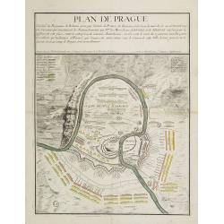
Plan de Prague.
Rare and separately published plan of Prague published by Joan Baptista Nolin with the address à l'enseigne de la Place des Victoires et chez le Sr. Humblot rue St. Jacqu...
- $550 / ≈ €481
Date: Paris, ca. 1742
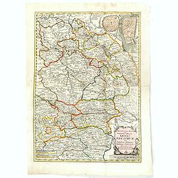
Marchionatus Moraviae circulus brunnensis..
Johann Baptist Homann's well-engraved map has a large decorative cartouche. Detailed map centered on Brunnensis, showing the main cities. Very decorative title cartouche ...
Date: Nuremberg, 1744
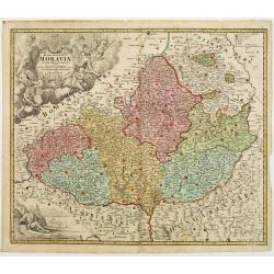
Tabula Generalis Marchionatus Moraviae..
Johann Baptist Homann's well-engraved map has a large decorative cartouche. Detailed map of the historic Moravia region of the Czech Republic, in the present-day Jihormor...
Date: Nuremberg 1744
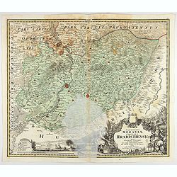
Marchionatus Moraviae circulus Hradistiensis..
Johann Baptist Homann's well-engraved map has a large decorative cartouche. Detailed map centered on Hradisch.Johann Baptist Homann (1663-1724) was a German engraver and ...
Date: Nuremberg 1744
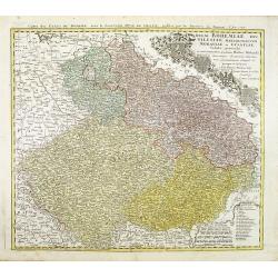
Regni Bohemiae, Duc. Silesiae, Marchionatuum Moraviae et Lusatiae. . .
Johann Baptist Homann's well-engraved map including the towns of Prague, Poznan/ Loda, Wroclaw, etc.This example was printed from plate A (1st of 3), which can be identif...
Date: Nuremberg, ca. 1748

Royaume de Bohéme, Marquisat de Moravie, et Silésie Autrichenne.
Small detailed map of today Czech Republic. From Atlas Portatif Universel, by Robert de Vaugondy.Unrecorded state with erased date. Page 32 outside border top right. Mary...
Date: Paris, later than 1749
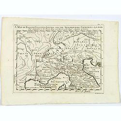
A Map of Gallia, Cisalpina, Liguria and the Neighbouring Countries.
A map of eastern France, Provence, northern Italy, then to Tuscany, whilst also showing northern Switzerland and Bavaria in Roman times. Showing Roman Provinces, a mileag...
Date: London, ca 1749
Marchionatus Moraviae circuli Znoymensis et Iglaviensis. . .
Map of the Znaym region of Moravia, the southern part of the Czech Republic, with figurative cartouche and small table of explanations. After Johann Christoph Müller publ...
Date: Nuremberg, 1750
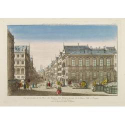
Vue perspective de la Place des Peintres ditte Perlach du cote de la Basse Ville a Prague.
A so-called optical print of a square in Prague by Basset, a well-known publisher of optical prints, was established in rue S.Jacques in Paris. With brief key list.In the...
Date: Paris, 1760
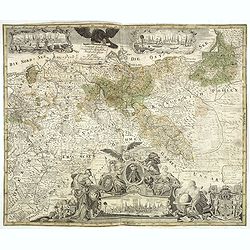
Generale Carte der gesamten Koniglichen Preussischen Lander. . .
Beautiful and rare two sheet map of Prussia. The title cartouche is hold by a crowned eagle. In lower part a large baroque cartouche with allegorical figures and a portra...
- $1200 / ≈ €1049
Date: Berlin, 1760
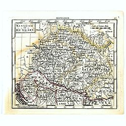
Kingdom of Hungary.
Uncommon miniature map of Hungary, engraved by Thomas Kitching for "A New General and Universal Atlas Containing Forty five Maps by Andrew Dury".This miniature ...
- $75 / ≈ €66
Date: London, 1761-1763
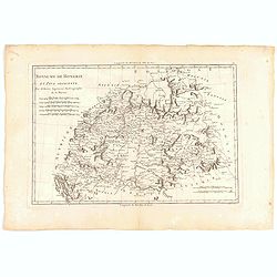
Royaume de hongrie et Pays Adjacents.
Map of the Northern part of the Kingdom of Naples, by Rigobert Bonne.
- $50 / ≈ €44
Date: Paris, 1771
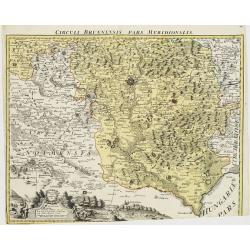
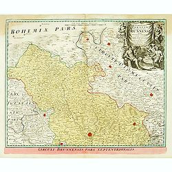
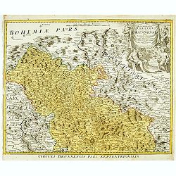
Circuli Brunnensis Pars Meridionalis.
Johann Baptist Homann's well-engraved and detailed map of the present-day South Moravia region centered on Brno, with decorative cartouche at the bottom.Johann Baptist Ho...
Date: Nuremberg 1770 - 1774
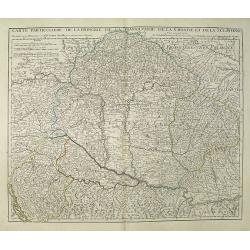
Carte Particuliere de la Hongrie de la Transilvanie de la Croatie et de la Sclavonie Dressée sur les Onservations de Mr. Le Comte Marsilli. . . Par G. Delisle.
Map of Hungary and Slovakia and adjacent parts of Croatia, Serbia and Romania (Transylvania). Prepared by Marsilli, published by Dezauche.
Date: Paris, ca. 1780
Carte topographique d'Allemagne contenant une partie du royaume de Boheme. . .
Detailed map cantered on Prague, Caaden, Laim, Melnik… Map 43 of the multi sheet map "Carte topographique d'Allemagne" of German Empire. Published by Johann Wil...
- $100 / ≈ €87
Date: Frankfurt, ca.1780
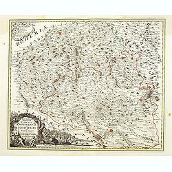
![[No title] Part of Eastern Europe, including Poland, the Czech Republic, Slovakia and Slovenia.](/uploads/cache/24266-250x250.jpg)
[No title] Part of Eastern Europe, including Poland, the Czech Republic, Slovakia and Slovenia.
Attractive map showing part of the course of the river Danube, from Germany to Hungary.Including Poland, the Czech Republic, Slovakia and Slovenia. Boundaries outlined in...
Date: Paris, ca 1783
Royaume de Hongrie.
Detailed map encompassing present day Hungary with the river Danube and the towns of Belgrade, Budapest, Vienna, etc.Venetian edition of the map by Bellin, to whom Santin...
Date: Venice, 1776 - 1784
Principauté de Transilvanie et Pays circonvoisins..
Detailed map encompassing part of present-day Hungary.From "Atlas Universel" published by Santini in 1784. The atlas is effectively an Italian copy of the Rober...
Date: Venice, 1784
Royaume d'Esclavonie et du Duché De Syrmie..
Detailed map encompassing show us Danube and to the right Belgrade.From "Atlas Universel" published by Santini in 1776-84. The atlas is effectively an Italian c...
Date: Venice, 1776 - 1784
Le Royaume de Boheme.. Moravie et Lusace.
Finely and crisply engraved map of Czechoslovakia, including Pilsen and part of Poland.Venetian edition of Giles Didier Robert De Vaugondy's map from Atlas Universel prin...
Date: Venice, 1777 - 1784

Le Royaume de Boheme, le Duché de Silesie, et les Marquisats de Moravie et Lusace, dresses d'apres les cartes de Muller . .
Map of Poland, Bohemia, Silesia, Moravia and Lusatia. Large decorative title cartouche in upper right. In upper left corner inset plan of Breslau and in lower right a ins...
Date: Paris, 1790
Karte von dem Konigreiche Boheim.
An attractive map of Bohemia. With a nice title cartouche decorated with cherubs in the upper right-hand corner. Engraved by Kil. Ponheimer.Franz Johann Josef von Reilly ...
- $300 / ≈ €262
Date: Vienna, 1796
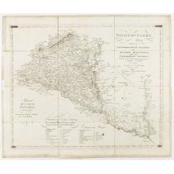
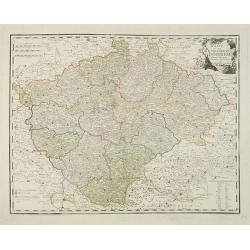
Niederungern Ivtes Blatt enthaltend die Schumegher, Tolner, Baranyer. . . Partie IVè de la basse hongrie contenant les comtes de Schumegh, de Tolna, de Baranya. . .
Map of Hungary. In the lower explicative key. Detailed map of the Southern part of Hungary with Kopreinitz until Lake Balaton, which is one of the most popular summer des...
Date: Kunst u. Industrie Compt., Vienna, 1803
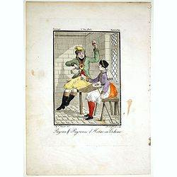
Paysan & Paysanne d'Hanas en Boheme.
Originally hand-colored mezzotint from 'Costumes civils actuels de tous les peuples connus'. Engraved by Lachaussée Jeune after Jacques Grasset de Saint-Sauveur.As an etc...
- $50 / ≈ €44
Date: Paris,1805

Karte vom Koenigreiche Ungarn mit Einschluss der Königreiche Kroazien und Slavonien dann von dem Grossfürstenthume Siebenbürgen.
Wall map of the Kingdom of Hungary in 8 sheets mounted on canvas, preserved in their original case. The map has a graduated margin and is enclosed in a simple yet decorat...
Date: Vienna, 1809
Situations = Plan. Der gegend zwischen der Kayserlich Königlichen Granitz Festung Essegg, und dem Dorffe Bellia....
Manuscript plan showing the Kopački Rit nature park a swampy area of Baranja between Osijek (Essegg) and Bilje. The river Drava in upper right corner. The pen an...
Date: Vienna, 1819
Carte de Moravie Dessinée et Gravée par Ambroise Tardieu.
Very detailed map including Vienna and the Czech Republic with Prague Olmutz.
- $40 / ≈ €35
Date: Paris, 1822
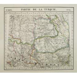
Europe. Partie de la Turquie. N°21.
Detailed map including Hungary and Romania.From his famous Atlas Universel . This atlas was one of the most remarkable world atlases ever produced, anticipating the Inter...
Date: Brussels, 1825-1827

Carte du pays de Montenegro dressée d'après les opérations géodétiques . . .
Rare map of Montenegro prepared by Mr. le Comte Fedor de Karacsay (1787-1859) and engraved by Pietro Allodi. The title is in Russian, Arabic and French.In lower left corn...
Date: Vienna, ca. 1838
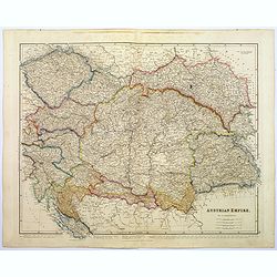
Austrian Empire.
A, large steel engraved map of the mighty Austrian Empire, covering Austria, Dalmatia, Styria, Slavonia, Hungary, Transylvania, Moravia and Bohemia. An enormous amount of...
Date: London, 1839
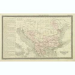
Turquie d'Europe.
Finely engraved map of Greece, Bulgaria, Romania, Albania and the east coast of the Black Sea, prepared by A.H.Dufour and engraved by Giraldon-Bovinet. Published by Jules...
Date: Paris, Jules Renouard, ca.1840
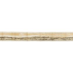
Panorama della Costa e delle Isole di Dalmazia nei viaggi dei piroscafi del Lloyd Austriaco.
On 20 August 1838 the Austrian Lloyd inaugurated a line service from Trieste to the Mouth of Cattaro. In order to illustrate the route, the Company asked the Trieste pain...
- $2500 / ≈ €2186
Date: Trieste, Linassi, 1857
![[Czech Republic] Provincia ecclesiastica di Praga nell' Impero Austriaco (Tav LXVIII)](/uploads/cache/44108-250x250.jpg)
[Czech Republic] Provincia ecclesiastica di Praga nell' Impero Austriaco (Tav LXVIII)
A large-format map of Czech Republic centered on Prague with its different dioceses. The map is finely engraved and beautifully colored and was prepared by Girolamo Petri...
- $300 / ≈ €262
Date: Rome, 1858
