Browse Listings in Europe > Eastern Europe > Balkans
![.[Balkan region with Austria, Croatia, Slovenia, Switzerland, etc]](/uploads/cache/33858-250x250.jpg)
.[Balkan region with Austria, Croatia, Slovenia, Switzerland, etc]
Wood block printed map and one of earliest printed representation of Balkan with Austria, Croatia, Slovenia, Switzerland, etc prepared Martin Waldseemüller. Based on the ...
Date: Vienna, 1525 -1541

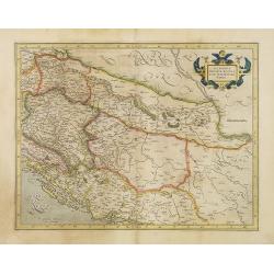
Schlavoniae, Croatiae, Carniale.. Bosniae. . .
First state. Fine and early map of former Yugoslavia after a map of Hirschvogel (1552-1565) and used by A.Ortelius in his atlas 'Theatrum Orbis Terrarum [Atlas of the Who...
Date: Antwerp, 1579

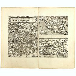
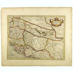
Carinthiae et Goritiae... / Histria tabula.../ Zarae, et Serebenici ..
Three maps on one sheet. The left hand is centered on the eastern part of Austria. The right upper hand map is centered on northern Yugoslavia, and the last map is center...
Date: Antwerp, 1598
![[View of Osero].](/uploads/cache/45194-250x250.jpg)
[View of Osero].
Very rare view of Osor published in the first edition of "Viaggio da Venetia, a Costantinopoli. Per Mare, e per Terra, & infieme quello di Terra Santa. Da Giosep...
- $400 / ≈ €350
Date: Venice, Giacomo Franco, 1598
![Glissa. [Klissza or Klis]](/uploads/cache/45203-250x250.jpg)
Glissa. [Klissza or Klis]
Very rare view of Klissza (Klis) published in the first edition of "Viaggio da Venetia, a Costantinopoli. Per Mare, e per Terra, & infieme quello di Terra Santa....
- $300 / ≈ €262
Date: Venice, Giacomo Franco, 1598
![Liesena Isola [Hvar]](/uploads/cache/45202-250x250.jpg)
Liesena Isola [Hvar]
Very rare view map of the Island of Hvar published in the first edition of "Viaggio da Venetia, a Costantinopoli. Per Mare, e per Terra, & infieme quello di Terr...
- $400 / ≈ €350
Date: Venice, Giacomo Franco, 1598
![Spalato [ View of Split]](/uploads/cache/45201-250x250.jpg)
Spalato [ View of Split]
Very rare view of Split published in the first edition of "Viaggio da Venetia, a Costantinopoli. Per Mare, e per Terra, & infieme quello di Terra Santa. Da Giose...
- $450 / ≈ €393
Date: Venice, Giacomo Franco, 1598
![Citta Di Trav [Trogir]](/uploads/cache/45200-250x250.jpg)
Citta Di Trav [Trogir]
Very rare map centered on the historic town of Trogir published in the first edition of "Viaggio da Venetia, a Costantinopoli. Per Mare, e per Terra, & infieme q...
- $300 / ≈ €262
Date: Venice, Giacomo Franco, 1598
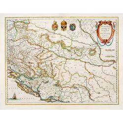
Carinthiae et Goritiae .. / Histria / Zarae / Serebenici. . .
Three maps on one sheet. The left-hand is centered on the eastern part of Austria. The upper right-hand map is centered on northern Yugoslavia, and the last map is center...
Date: Antwerp, 1598
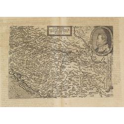
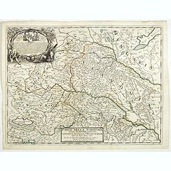
Sclavonia Croatia, Bosnia & Dalmatiae Pars Maior.
Mattheus Quadt's map of the western Balkan with a portrait of the Roma.Matthias Quadt (1557-1613) was a Dutch geographer who worked in Cologne. From "Geographisch ha...
Date: Cologne, 1600
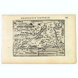
Sara et Zebenic.
A miniature map of Sara & Zebenic - in Croatia / Dalmatia in Eastern Europe, published by Petrus Bertius in Amsterdam, at the beginning of the seventeenth century. An...
- $100 / ≈ €87
Date: Amsterdam, 1606
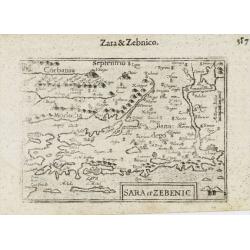
Sara et Zebenic.
A miniature map of the islands of Dalmatia. Title cartouche on the lower left side.First published in 1598 in his Caert-Thresoor, the plates were executed by the most fam...
- $100 / ≈ €87
Date: Amsterdam / Frankfurt, 1609
Sclavonia, Croatia, Bosnia cum Dalmatiae parte.
Nice map of the Eastern Balkans with the political divisions of Slovenia, Croatia, Bosnia and Dalmatia.Mercator was born in Rupelmonde in Flanders and studied in Louvain ...
Date: Amsterdam 1630
Sclavonia, Croatia, Bosnia cum Dalmatiae parte.
Nice map of the Eastern Balkans with the geographical & political divisions of Dalmatia, Croatia, Slavonia, Bosnia, Serbia, etc.Mercator was born in Rupelmonde in Fla...
- $250 / ≈ €219
Date: Amsterdam, 1632
Sclavonia, Croatia cum Dalmatiae Parte.
Excellent map with coat-of-arms focusing specifically on the embattled nations of the former Yugoslavia.
Date: Amsterdam, 1638
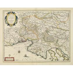
Karstia, Camiola, Histria et Windorum Marchia.
Including the Gulf of Trieste, Venice and the northern part of former Yugoslavia. Prepared by Gerard Mercator.As Willem Blaeu died in 1638 most of his maps are actually p...
Date: Amsterdam, 1638
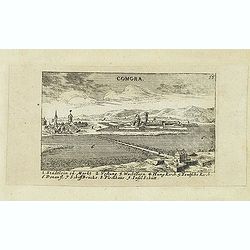
Comora.
Panoramic view of Comora. Published in "Der Donau-Strand Mit allen seinen Ein- und Zuflüssen. . .". Published by Jacob Sandrart.
Date: Nuremberg, Jacob Sandrart, 1684
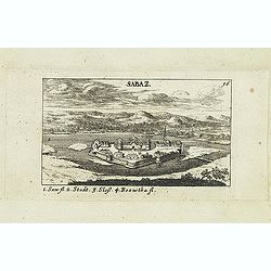
Sabaz. (Sabac)
View of Šabac in western Serbia, along the Sava river.Published in "Der Donau-Strand Mit allen seinen Ein- und Zuflüssen. . .". Published by Jacob Sandrart.
- $75 / ≈ €66
Date: Nuremberg, Jacob Sandrart, 1684
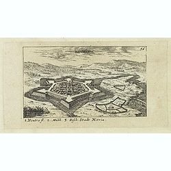
Neuhäusl. (Nové Zámky)
Panoramic view of Nové Zámky, in southwestern Slovakia.Published in "Der Donau-Strand Mit allen seinen Ein- und Zuflüssen. . .". Published by Jacob Sandrart.
- $75 / ≈ €66
Date: Nuremberg, Jacob Sandrart, 1684
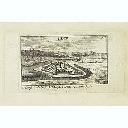
Sissek.
Panoramic view of Sisak in Sisak in central Croatia. Published in "Der Donau-Strand Mit allen seinen Ein- und Zuflüssen. . .". Published by Jacob Sandrart.
- $75 / ≈ €66
Date: Nuremberg, Jacob Sandrart, 1684
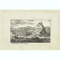
Novigrad.
Panoramic view of Nógrád in northern Hungary. Published in "Der Donau-Strand Mit allen seinen Ein- und Zuflüssen. . .". Published by Jacob Sandrart.
Date: Nuremberg, Jacob Sandrart, 1684
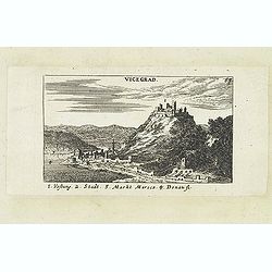
Vicegrad.
Panoramic view of Vicegrad. Published in "Der Donau-Strand Mit allen seinen Ein- und Zuflüssen. . .". Published by Jacob Sandrart.
Date: Nuremberg, Jacob Sandrart, 1684
Parte della Schiavonia, overo Slavonia, aggiuntavi la contea di Cilles e Windisch mark abitate da populi slavini, ò slavi. . .
The map of Slavonia by Cantelli from his atlas “Mercurio Geografico” issued in Rome in 1690 by the publisher and printer Giacomo Rossi. The map shows parts of the medieva...
- $400 / ≈ €350
Date: Rome, 1690
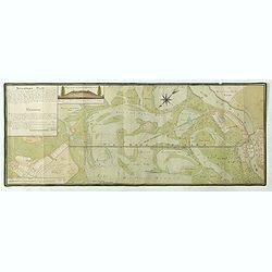
Situations = Plan. Der gegend zwischen der Kayserlich Königlichen Granitz Festung Essegg, und dem Dorffe Bellia....
Manuscript plan showing the Kopački Rit nature park a swampy area of Baranja between Osijek (Essegg) and Bilje. The river Drava in upper right corner. The pen an...
Date: Vienna, 1819
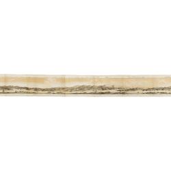
Panorama della Costa e delle Isole di Dalmazia nei viaggi dei piroscafi del Lloyd Austriaco.
On 20 August 1838 the Austrian Lloyd inaugurated a line service from Trieste to the Mouth of Cattaro. In order to illustrate the route, the Company asked the Trieste pain...
- $2500 / ≈ €2186
Date: Trieste, Linassi, 1857
![Mer Adriatique. Côte Orientale. De l'Ile Meleda à Antivari.. [3552]](/uploads/cache/23471-250x250.jpg)
Mer Adriatique. Côte Orientale. De l'Ile Meleda à Antivari.. [3552]
This large scale coastal chart shows the stretch of Dalmatian coast between the island Mljet in Croatia as far as Ulcinj (Montenegro). With latitude and longitude scales,...
- $200 / ≈ €175
Date: Paris [1877] corrected to 1934
![Mer Adriatique. Partie Sud.. [3976]](/uploads/cache/23549-250x250.jpg)
Mer Adriatique. Partie Sud.. [3976]
This large scale coastal chart centered on the southern part of the Adriatic sea. Showing the Dalmatian coast between Split in Croatia as far as the northernmost tip of C...
- $200 / ≈ €175
Date: Paris [1883] updated for 1935
MEMORANDUM Vlade Demokratske Federativne Jugoslavije po pitanju Juliske Krajine i drugih jugoslavenskih teritorija pod Italijom.
Memorandum of the government of the Democratic Federative Yugoslavia concerning the questions of the Jilian March and other Yugoslav territories under Italy.Julian March ...
- $300 / ≈ €262
Date: London, 1946
