Browse Listings in Europe > Belgium > Belgium Provinces
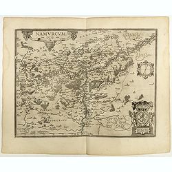
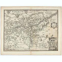
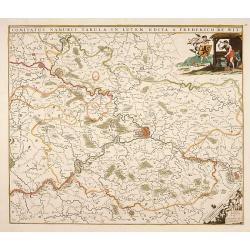
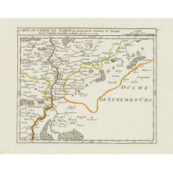
Namurcum Comitatus.
Prepared by Jacques Surhon in 1555. His manuscript map was, for security reasons not published. Only in 1579, when Antwerp was independent for a short time, Ortelius used...
Date: Antwerp, 1598
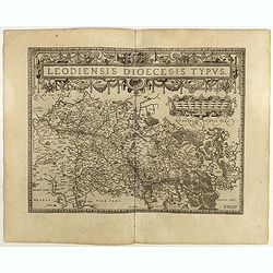
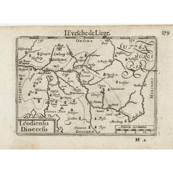
Leodiensis Diocesis Typus.
East to the top. Centered on Liege, including the southern part of Dutch Limburg. Prepared by Jan van Schille.Dare to go in Black. All early maps were printed in black an...
Date: Antwerp, 1598
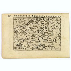
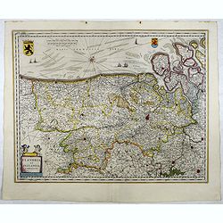
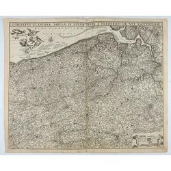
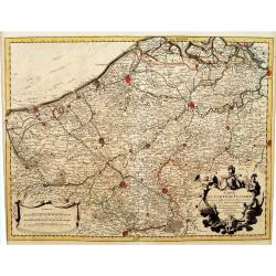
Flandria.
A lovely set of miniature map of Flanders. With an attractive strap-work title, and with detailed topography and information. Bertius (1565-1629) was a Flemish cartograph...
Date: Amsterdam, 1606
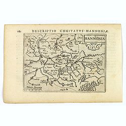
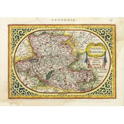
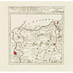
Hannonia.
An attractive miniature map of the Belgian, region of Hainaut, published by Petrus Bertius, in Amsterdam at the beginning of the seventeenth century. It features a small ...
Date: Amsterdam, 1606
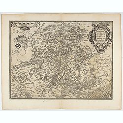
Leodiensis Dioecesis.
A miniature map of the southern part of Belgium centered on Liege. The title cartouche on the lower left corner.First published in 1598 in his Caert-Thresoor, the plates ...
- $75 / ≈ €65
Date: Amsterdam / Frankfurt, 1609
Namurcum Comitatus.
Prepared by Jacques Surhon in 1555. His manuscript map was for security reason not published. Only in 1579, when Antwerp was independent for a short time, Ortelius used a...
- $500 / ≈ €435
Date: Antwerp, after 1612

Flandria.
Very decorative, egg-shaped map. This is the last and very rare third state with the signature Theodorus Galle. The fortifications along the Scheldt River are added and t...
Date: Antwerp, after 1612
Comitatus Hannonia.
Detailed map of the Belgium province Hainault or Henegouwen. Including the towns of Mons, Geraadsbergen, etc.Uncommon and decorative oval map in a rectangular frame, the ...
Date: Amsterdam, 1616
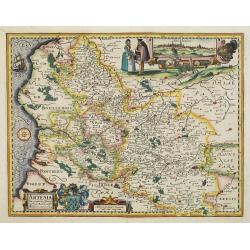
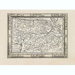
Artesia descriptio.
Very rare. The map is dated 1624 which is unknown to Van der Krogt. Très rare, Van der Krogt ne signale pas cette édition de 1624, qui est postérieure à la dernières édit...
Date: Amsterdam, 1624

Kaerte van Bergen op Zoom, Steenbergen ende de nieuwe fortificatien gemaeckt tot bevrÿdinge van 't landt van ter Tolen in tjaar 1628.
Very detailed and scarce map showing Bergen Op Zoom, Steenbergen and its surrounding countryside. North to the left side.
Date: Amsterdam, after 1628

Comitatus Flandria.
First published by the van Langrens c.1595, after his acquisition of the plate, Visscher heavily re-engraved the map, inserting panelled borders on three sides (the lower...
Date: Amsterdam, c. 1630
Nobilis Hannoniae Comitatus Descrip.
Fine map of Hannonia (Hainaut), with ornate cartouches, two coats of arms, etc. Showing the cities of Charleroi, Mons, Ath, Tournay, Valenciennes, Maubeuge, etc. in Belgi...
- $600 / ≈ €522
Date: Antwerp, 1612-1641
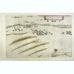
Afbeeldinge vande vermaerde seehaven .. Duynkerken..
Blaeu's map of the coast of the French coast from Duinkerk till Waldamme. In an inset, lower right the continuation till Calais. Many ships offshore Duinkerk, with soundi...
- $500 / ≈ €435
Date: Amsterdam, 1645
Flandria et Zeelandia Comitatus.
Includes Flanders and Zeeland. The map originally engraved in 1641 for Sanderus 'Flandria Illustrata', was used several times in Blaeu's atlases.More about maps by Willem...
- $250 / ≈ €217
Date: Amsterdam, 1645

Comitatus Flandria.
A highly decorative map with in the left and right top corners the pictures of archduke Albert of Austria and Isabella, queen of Spain. In the left and right borders cost...
Date: Amsterdam, 1648
Carte du Comté de Flandre. . .
Decorative map of Flanders from Plans, et Profils des principales villes.. by Ch. De Beaulieu. Etched by mr. Romeijn de Hooghe.
Date: Paris, 1668
Comitatus Flandriae Tabula, In Lucem Edita A Frederico De Wit.
Double page map of Flanders, the whole Belgian region northwest of Brussels, confined by Antwerp, Brussels, valenciennes, Arras, St. Omer and the Channel. Title heading a...
Date: Amsterdam, 1680
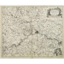
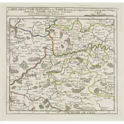
Comitatus Namurci Tabula in Lucem. . .
Centered on Namen, with decorative title cartouche upper right.
Date: Amsterdam, 1680
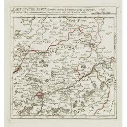
Comitatus Namurci Emendata Delineatio, Nuperrimè in lucem edita, per Nicolaum Visscher.
Detailed engraved map of the province of Namur (Namen), showing cities including Charleroi and Dinant., towns, rivers and lakes. Decorative cartouche with putti. Explanat...
Date: Amsterdam, 1684

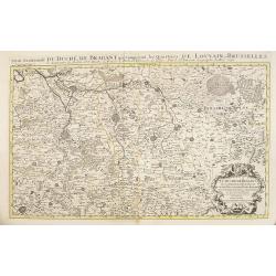
Le comte de Namur et partie des Duchez de Brabant. . .
Decorative map centered on Namen and including the towns of Liege, Leuven, Charleroi, Dinant, Luxemburg, etc. by François Jollain (ca. 1641 – 18 April 1704).Rare "ca...
Date: Paris, c. 1692
Partie meridionale du Duché de Brabant comprend les Quartiers de Louvain et Brusselles. . .
Fine map of the Duchy of Belgium Brabant with a figurative armorial cartouche and small scale of miles. Boundaries outlined in hand color. The map is fully and richly eng...
Date: Amsterdam, 1692
![Flandra parte occidentale: dedicata all'illustrissimo et eccelententissimo S. Giorgio Cocco, senatore meritissimo. . . [together with] Zelanda e Parte Orientale della Flandra. . . .](/uploads/cache/31286-250x250.jpg)
Flandra parte occidentale: dedicata all'illustrissimo et eccelententissimo S. Giorgio Cocco, senatore meritissimo. . . [together with] Zelanda e Parte Orientale della Flandra. . . .
Wall sized map of two joined sheets of Flanders, the coastline running from Calais to Zeeland in the Netherlands. Including major cities along the coast such as Dunkerque...
Date: Venice, 1696
Carte du Comté de Flandre, Dressée sur differens. . .
Large, detailed map of the Flanders including the French Flemish-speaking area. Shows illustrated topography with notations about towns, roads, fortresses, abbeys, monast...
Date: Amsterdam, c. 1745
VI. Carte du Duché de Limbourg où sont les environs de Limbourg.
Attractive small map showing part of the Wallon region, centered on Limburg. Dated 1748. From Atlas Portatif Universel, by Robert de Vaugondy.Page 15f outside border top ...
Date: Paris, 1748
![[IV.] Carte du Brabant où se trouvét la Mairie de Santhoven.. Ryen.](/uploads/cache/24684-250x250.jpg)
[IV.] Carte du Brabant où se trouvét la Mairie de Santhoven.. Ryen.
Nice small map encompassing an area which straddles the border between Belgium and the Netherlands.Showing Antwerp in the central lower part. From Atlas Portatif Universe...
Date: Paris, later than 1748
V. Carte du Brabant ou se trouvét les Mair.s d'Herentals.. Hochstraten.
Nice small map illustrating the northeastern part of the Flemish region. Centered on Turnhout.From Atlas Portatif Universel, by Robert de Vaugondy. Unrecorded state with ...
Date: Paris, later than 1748
![[X.] Carte du Brabant où sont les environs de Tillemont, de Judoigne, de Gemblours &c.](/uploads/cache/24690-250x250.jpg)
[X.] Carte du Brabant où sont les environs de Tillemont, de Judoigne, de Gemblours &c.
Nice small map straddling the Flemish and the Walloon regions. Extending North to South from Tienen to Gembloux.From Atlas Portatif Universel, by Robert de Vaugondy. Unre...
Date: Paris, later than 1748
VI. Carte du C.té de Namur où sont les environs de Namur.. Huy.
Attractive small map illustrating part of the Walloon Region, between Namur and Huy. From Atlas Portatif Universel, by Robert de Vaugondy.Unrecorded state with erased dat...
Date: Paris, after 1748
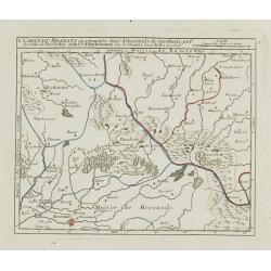
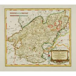
V. Carte des C.tes de Haynaut et de Namur. . .
Attractive small map illustrating part of the Walloon Region, centered on Charleroi. From Atlas Portatif Universel, by Robert de Vaugondy.Unrecorded state with erased dat...
Date: Paris, after 1748
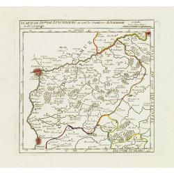
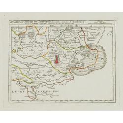
I. Carte du D.ché de Luxembourg ou sont les Frontieres du Namurois et du Lyegeois.
Charming small map representing part of the Walloon Region, delimited by the towns of Namur, Huy, Dinant and Ciney.From Atlas Portatif Universel, by Robert de Vaugondy. E...
Date: Paris, later than 1749
![[IX.] Carte du Brabant ou sont les Mairies de Roo, de Nivelle, de Hulpen, et de Geneppe.](/uploads/cache/24689-250x250.jpg)
[IX.] Carte du Brabant ou sont les Mairies de Roo, de Nivelle, de Hulpen, et de Geneppe.
Nice small map straddling the Flemish and the Walloon regions. It shows Halle, Nivelles, La Hulpe, Overijse, Genappe, etc.From Atlas Portatif Universel, by Robert de Vaug...
Date: Paris, later than 1749
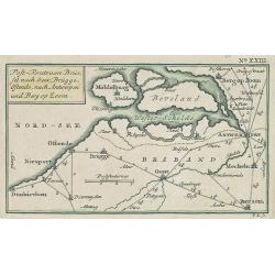
Post-Route von Brüssel nach Gent, Brügge, Ostende, nach Antwerpen und Bergen op Zoom. N°XXIII
Very rare post route maps map centered on Gent, and showing the postal routes in-between Oostende, Bruges, Gent, Brussels, Mechelen, Lier, Antwerp, Bergen op Zoom, etc. f...
Date: Nürnberg, Weigel and Schneider, ca.1785
Des Hochstifts Luttich..
Uncommon map covering the area of Limburg in present day Belgium. Also including western borderline of the Dutch province of Limburg.
Date: Vienna, 1791
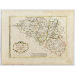
I Paési Bassi Austriaci.
A rare and detailed map of Belgium by Pazzini, Carli (1707-1769) and Bartolomeo Borghi (1750-1821). Features decorative title cartouche. Included in "Atlante Geogra...
- $125 / ≈ €109
Date: Siena, 1796
X. Carte du Comté de Namur où se trouvent les environs de Dinant.
Attractive small map showing an area straddling the border between France and Belgium.It shows Dinant, Ciney, and the fort of Charlemont, built by Charles V on the French...
Date: Paris, 1799
I. Carte du Comté du Haynaut.. Tournay.
Attractive small map encompassing part of Hainaut, between Tournai and Ath. From Atlas Portatif Universel, by Robert de Vaugondy.Edited by : "Au dépôt de Géographie,...
Date: Paris, 1799
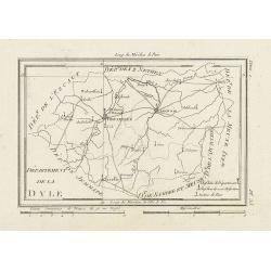
Département de la Dyle.
Map centered on Bruxelles with a short key list in the lower right corner. From Atlas de la Géographie de toutes les parties du monde .. Ouvrage destiné pour l'education,...
Date: Paris, Prudhomme, Levrault, Debray, 1806
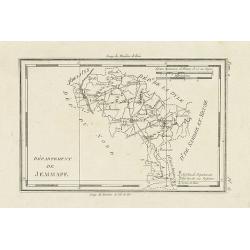
Département de Jemmape.
Map representing the area around Mons, with a short key list in the lower right corner.From Atlas de la Géographie de toutes les parties du monde .. Ouvrage destiné pour ...
Date: Paris, Prudhomme, Levrault, Debray, 1806
